Interstate 69


Overview
Interstate 69 currently consists of a disconnected route along a 1,660 mile long corridor (FHWA, 2012). The original section stretches northward from I-465 at Indianapolis, Indiana to the Bluewater Bridge alongside I-94 at Port Huron, Michigan. Additional segments of Interstate 69 are designated from the Gulf Coast to the Midwest:
- Rosenburg northeast to Houston and Cleveland in southeast Texas
- East from U.S. 61, north of Tunica, in northern Mississippi to I-240/SR 300 in Memphis, Tennessee
- Within western Kentucky, northeast from the Tennessee state line at Fulton to U.S. 41 at Henderson
- Evansville northeast to Bloomington, Martinsville and Indianapolis.
The long range goal is to unite all of the separate sections into a seamless corridor linking Canada with Mexico.
Interstate 69 connects the cities of Indianapolis, Indiana with Lansing, Flint and Port Huron, Michigan within the Great Lakes region. Connecting the capital city with Muncie, Fort Wayne and Angola in northeastern Indiana, the route originally began at the Indianapolis Beltway (Interstate 465). Through Fort Wayne, I-69 passes west of Downtown while a beltway, Interstate 469, encircles the Summit City to the east as both a commuter route and connection to the Fort to Port Corridor, U.S. 24 leading east to Toledo, Ohio. Also in Fort Wayne, I-69 overtakes the former route of U.S. 27 north to Lansing, Michigan.
Crossing into the Great Lakes State, I-69 heads northerly to Marshall and a junction with Interstate 94 before shifting eastward toward the capital city of Lansing. Business loops along the route serve communities bypassed along old U.S. 27. Once in the Lansing area, I-69 changes directions. Removed by 2011, a sign indicated that I-69 north becomes I-69 east. Beyond Lansing and the overlap with Interstate 96, I-69 crosses I-75 at a nearly 90 degree angle within the city of Flint and then meets Interstate 475. The freeway returns to rural areas east of Flint en route to Lapeer and Port Huron. Once in Port Huron, I-69 and I-94 meet for a second time and combine eastward to the Blue Water Bridge to Sarnia, Ontario.
The first section of I-69 south of Indiana posted was the 14.7 mile stretch between U.S. 61 near Tunica and Interstate 55 by Hernando, Mississippi. This route generally serves as a connector for through traffic heading south to U.S. 61 and an area of casinos from I-55 north into Memphis, Tennessee. A subsequent extension of I-69 made in 2008 lengthened the route alongside I-55 north into Memphis.
Main guide: Interstate 69 Mississippi
Road work in 2009 added 1.77 miles of Interstate 69 in southwestern Indiana. This short stretch tied into the cloverleaf interchange joining I-64 and I-164. It was lengthened in 2012 northeast by 67 miles to U.S. 231. By 2013, the 20 miles of I-164 at Evansville were redesignated as the southernmost alignment of I-69 in the Hoosier State. Construction on I-69, Section 4 followed with 27 more miles of freeway opened between Crane and Bloomington in December 2015. Substantially completed by October 30, 2018, Section 5 extended I-69 another 21 miles to Martinsville.
Three parkways in Kentucky were incorporated into the route of Interstate 69. Starting with the Western Kentucky Parkway, I-69 was designated between I-24 at Eddyville and the Pennyrile Parkway near Nortonville in 2011. An extension of I-69 west to Mayfield along the Julian Carroll-Purchase Parkway, including a 17 mile long overlap with I-24, was established in 2015. I-69 was also designated along the Pennyrile Parkway north from the Western Kentucky Parkway to Henderson in 2015. Lengthening I-69 south to Fulton, the western 21 miles of the Purchase Parkway were upgraded to Interstate standards in 2024.
Section 1 of the Interstate 69 Ohio River Crossing (ORX) extended I-69 six miles further north to U.S. 60 at Henderson. Construction included upgrading three miles of freeway along U.S. 41 to Interstate standards and building 2.5 miles of new roadway east to U.S. 60. A ribbon cutting ceremony took place for Section 1 on November 3, 2025.
Additional stretches of Interstate 69 were added following the 2012 legislation Moving Ahead for Progress in the 21st Century (MAP-21) stating that
routes can be designated as part of the Interstate system if the route or a segment of the route meets current Interstate design standards and connects to, or is planned to connect to, an existing Interstate within 25 years.
This meant that sections of freeway that will eventually become part of a seamless Interstate 69 may receive shielding in advance, even if they are disconnected from the rest of the designated mainline.

One of the first signs posted for Interstate 69 along the U.S. 59 freeway through Houston, Texas. Photo by Jeff Royston (09/27/12).
Through southeastern Texas, IH 69 overlays U.S. 59 north from Rosenberg to the Montgomery / Liberty County line. These stretches were signed over the span of three years between 2012 and 2015. They joined shorter segments of the three IH 69 branch routes in South Texas. IH 69E, the 6.2 mile long route between SH 44 and IH 37 near Corpus Christi was designated in 2011 initially as just IH 69. It was renumbered as IH 69E in 2013 when IH 69C and IH 69E in the Rio Grande Valley were dedicated. IH 69W appeared in 2014 when the Federal Highway Administration (FHWA) approved a 1.4 mile long stretch of Loop 20 in Laredo as an Interstate highway.
Main guide: Interstate 69 Texas
High Priority Corridor
Interstate 69 from Texas northeast to Michigan in its entirety is part of High Priority Corridor 18: NAFTA Superhighway. The section within Texas is also part of High Priority Corridor 20: U.S. 59 from Laredo to Texarkana.
 Parallel U.S. Routes
The existing section of Interstate 69 northeast of Indianapolis largely does not follow any historic U.S. route, with the exception of the stretch between Fort Wayne and Lansing, where it supplanted U.S. 27.
Interstate 69 along the Purchase Parkway in southwestern Kentucky parallels U.S. 45 between Fulton and Mayfield and U.S. 641 between Benton and Draffenville. Including the overlap with I-24, I-69 east from Lake City to I-169 at Nortonville follows U.S. 62. Northward along the Pennyrile Parkway between Nortonville and Henderson, I-69 parallels U.S. 41.
Corridor Progress
Planned as a 1,250 mile extension to Laredo, Texas, from Indianapolis southwest through Evansville, Memphis, Shreveport and Houston, Interstate 69 is part of High Priority Corridors 18 and 20. These High Priority Corridors are in turn subdivided into “segments” for ease of reference in various environmental and planning documents. For additional historical information, visit Chris Lawrence’s I-69 Info.com web page.
Texas
The entire corridor is described on the Alliance for I-69 Texas web site. Interstate 69 splits into three branches so it can serve the border areas near Laredo and near Brownsville:
- Interstate 69W – Victoria to Laredo via U.S. 59
- Interstate 69C – Rio Grande Valley/McAllen via U.S. 281
- Interstate 69E – Rio Grande Valley/Brownsville via U.S. 77
IH 69 began in Texas as a 6.2 mile route alongside U.S. 77 between SH 44 at Robstown and IH 37 at Corpus Christi, with an official dedication on December 5, 2011. This portion was reclassified as IH 69E at the May 5, 2013 Route Numbering Committee meeting of AASHTO, because of the branch split of IH 69 south from Victoria.
Other branch route sections of IH 69 were signed starting on July 15, 2013. Included is IH 69E, which overlays a stretch of U.S. 77 from Brownsville to Raymondville; IH 69C, which superseded 18.0 miles of U.S. 281 between Pharr and Edinburg and IH 2, which overlaps with U.S. 83 and connects IH 69C and IH 69E in the Lower Rio Grande Valley. 73 miles of State Highway 44, from U.S. 59 at Freer to SH 358 in Corpus Christi, became a Congressionally Designated I-69 High Priority Corridor as part of the FAST Act signed into law on December 4, 2015. 5.8 miles of SH 44 by Corpus Christi International Airport (CRP) were previously built to interstate standards (Alliance for I-69 Texas, 2015).
North from the merge of IH 69E and IH 69C near Victoria to Houston, IH 69 will directly overlay U.S. 59 along Segment 20, from Victoria to SH 99. Through the Houston area, IH 69 runs concurrent with U.S. 59 on Segment 19 while SH 99, the Grand Parkway, provides a tolled bypass and possible branch of IH 69. Signage for IH 69 was added along U.S. 59 from the north loop of IH 610, 35 miles to the Montgomery / Liberty County line in September 2012. Signs designating IH 69 within the IH 610 beltway in Houston were posted beginning in April 2015.
IH 69 continues along U.S. 59 to depart Houston northward toward Cleveland (Segment 18 – from SH 99 to Lufkin). IH 69 converge with U.S. 69 around Lufkin. Northeast from there, IH 69 will angle to Nacogdoches via Segment 17, then continue to Carthage and Panola via Segment 16.
Main guide: Interstate 69 Texas
A spur freeway (Segment 29), designated Interstate 369, is proposed to follow U.S. 59 north past Carthage to Texarkana, while IH 69 will turn east into Louisiana via Segment 16 – Nacogdoches to Stonewall, Louisiana and Segment 15. Approved by AASHTO on November 15, 2012, IH 369 constitutes a 4.2 mile long spur along U.S. 59, south from IH 30 on the west side of Texarkana to FM 93 and SL 151.
Route Information
Mileage
Texas – 74.55
Cities – Corpus Christi, Houston, Humble, Stafford, Sugar Land
Junctions –


Mississippi – 23.90*
Cities – Hernando
- Junctions –
Tennessee – 14.00**
Cities – Memphis
- Junctions – Future
Kentucky – 151.67
Cities – Princeton
- Junctions –

Indiana – 300.07
Cities – Evansville, Bloomington, Indianapolis, Anderson, Muncie, Fort Wayne
Junctions –
Michigan – 198.30†
Cities – Coldwater, Battle Creek, Lansing, Flint, Port Huron
Junctions –
Source: December 31, 2021 Interstate Route Log and Finders List
TxDOT Statewide Planning Map
KYTC Functional Classification Interactive Map
* – 9.20 miles on I-55
** – 5.8 miles on I-55, 5.2 miles on I-240, 3.0 miles on I-40
† – 5.20 miles on I-96
I-69 Annual Average Daily Traffic (AADT)
| Location | Vehicles per day |
|---|---|
| Rosenberg, TX | 71,872 |
| Houston, TX | 336,972 |
| Cleveland, TX | 41,944 |
| Indianapolis, IN | 148,236 |
| Fort Wayne, IN | 76,642 (2018) |
| Angola, IN | 18,061 |
Source: 2019 AADT – INDOT Traffic County Database System (TCDS)
2017 AADT – TxDot Statewide Planning Map

IH 37 northbound at the north end of the first IH 69 segment designated in Texas. This was later changed to IH 69E. Photo by Jeff Royston (12/05/11).

Eastbound begin sign posted on the Interstate 69 leg from U.S. 61. 06/02/10

The first shield posted for Interstate 69 south along the Western Kentucky Parkway. 11/07/11

Interstate 69 in southwestern Monroe County east of the Harmony Road overpass. This section of I-69 opened to traffic on December 9, 2015. Photo by Thomas Decker (01/02/16).

The Northeast Freeway leading south from Binford Boulevard by the Indiana State Fairgrounds south toward Downtown Indianapolis was dropped during the 1960s. Binford Boulevard was later expanded into a multi-lane arterial and dropped as State Road 37 when all routes within the Indianapolis Beltway were decertified.

Interstate 69 was initially proposed to extend north from Indiana to Interstate 94 near Marshall. The route would later replace U.S. 27 north to Lansing and M-78 east from Lansing to Flint
Louisiana
Interstate 69 will cross into Louisiana from Texas between U.S. 79 and U.S. 84 near Carthage, Texas, between Logansport and Bethany. Heading northeast, I-69 will head toward Shreveport and Bossier City approximately along LA 525, then angle roughly toward Haynesville before entering Arkansas via AR 15. It is likely that Interstate 69 will stay south of Shreveport by avoiding I-20 and crossing I-49 south of Shreveport.
Arkansas
Paralleling U.S. 63/167, Interstate 69 will enter Arkansas just southwest of El Dorado. Segment 13 connects El Dorado with McGehee. While the highway will generally parallel U.S. 63, it will utilize a new alignment.
Segment 12 connects McGehee with Benoit, Mississippi. Segment 12 includes a new Mississippi River crossing east of McGehee. Through Arkansas, Interstate 69 will pass through Warren, Monticello and Dumas, roughly paralleling U.S. 82 and U.S. 165. A connection to Interstate 530 is planned near Monticello (since I-530 is considered part of the I-69 corridor, it has been designated as Segment 28), and this will allow for a variation on the “Dickey Split” so that I-69 has a direct freeway connection to Little Rock. I-69 may also follow portions of U.S. 167, U.S. 63 (old AR 15), and U.S. 278 (old AR 4) between El Dorado and McGehee.
The Monticello Bypass is the first section of I-69 being built in Arkansas. Designated as U.S. 278 Bypass, the two-lane at-grade expressway arcs northeast from AR 83 to U.S. 278 to the southeast of the Drew County seat. Running ahead of schedule, construction on extension of the bypass east to AR 293 is expected in June 2026 (TBKS1, 2025).

Future Interstate 69 corridor signs appear in southeastern Arkansas. This assembly appeared along U.S. 278 east, three miles beyond the split with Arkansas 35 near Monticello. 05/07/12
Mississippi
The Great River Bridge is the crossing Interstate 69 proposed to take across the Mississippi River. Planned at Rosedale, Mississippi, as a compromise location between Mississippi and Arkansas, the span is being designed as a four lane, Interstate standard bridge, contingent upon I-69 being constructed to the bridge. Leading away from the river, I-69 will turn north along U.S. 61 toward Memphis.
The section from U.S. 61 near Tunica to I-55/269 north of Hernando opened on October 3, 2006 (Risher, 2006). On May 6, 2008, the Interstate 69 designation was extended north on shared alignments with I-55, I-240 and I-40 through Memphis, Tennessee, after approval by AASHTO. Signs in Tennessee however only refer to “Future Interstate 69”.
Main guide: Interstate 69 Mississippi
Tennessee
Part of High Priority Corridor 18, there are three designated Segments to be built within western Tennessee.
Through Memphis, I-69 utilizes I-55, I-40 and I-240 north to the SR 300 freeway spur as part of Segment 9 (Hernando, Mississippi to Millington). This was the alignment recommended by the Memphis Metropolitan Planning Organization and the City of Memphis. Much of the route along I-55 and I-40 incorporated into I-69 through Memphis was improved by 2010 to carry between six and eight lanes. A beltway route, Interstate 269, bypasses the city to the east via a course parallel to MS 304 in DeSoto County and along the SR 385 freeway between Millington and Collierville. I-269 was completed between I-55/69 in Mississippi and I-40 in Tennessee on October 26, 2018.
Beyond the Memphis belt line, Segment 8 (Dyersburg to Millington) for I-69 will take SR 300 northwest to U.S. 51, then parallel U.S. 51 to the west to Covington. The freeway will overtake U.S. 51 across the Hatchee River before shifting east of U.S. 51 around Ripley and west of U.S. 51 again to I-155/U.S. 412 at Dyersburg.
Segment 7 is the corridor from Dyersburg northeast to Union City and Fulton, Kentucky. The Tennessee Department of Transportation (TDOT) awarded a contract for Section 5 of SUI 7 on March 29, 2019. The contract outlined the construction of 4.87 miles of roadway from west of SR 21 to U.S. 51 near Mayberry Road in Obion County (ITB, 2018). Estimated for completion in Summer 2023, a $31.9 million paving project kicked off on July 13, 2021 on a 6.5 mile long stretch of I-69 around Unionville (WBBJ, 2021). Sections 1 and 2 of SIU 7 will eventually complete the link to Interstate 155 (ITB, 2019).
Costing $220 million and designated as Tennessee State Route 690, Future I-69 along Segment 7 opened around Union City from U.S. 51 to SR 21 on February 21, 2024 (WBBJ, 2024). This segment ties into the existing freeway along U.S. 45W/51 joining Union City with South Fulton near the Kentucky state line.
With construction anticipated to begin in 2028, a project under development will complete the Interstate standard connection to I-69 along the Purchase Parkway in Fulton, Kentucky. Alternative 2C, the Preferred Alternative, upgrades U.S. 51 to a new sweeping curve to the east near KY 116 (State Line Road). The project also includes reconstructing the interchange joining U.S. 51/45E/45W. The Tennessee Department of Transportation (TDOT) held a public meeting for the I-69 Interchange Re-configuration project on March 20, 2025 (Heller, 2025).
Kentucky
Interstate 69 runs north from the Tennessee state line with U.S. 51 on the Julian M. Carroll Purchase Parkway at Fulton. The $33.9 million in construction upgrading 21 miles of the Purchase Parkway to Interstate standards from Fulton north to Mayfield was part of Segment 6 (Fulton north to Eddyville). Governor Andy Beshear announced the completion of the two year project on December 24, 2024. Work included reconfiguring the cloverleaf at Exit 14 originally designed to accommodate toll booths into a diamond interchange (Latek, 2024).
I-69 is posted along the Purchase Parkway from KY 80 at Mayfield northeast to Interstate 24. Between 1991 and 1999, it appeared as if I-69 would be constructed on a new alignment from the parkway end northeast to Henderson, Kentucky. However, in May 1999, the state of Kentucky announced that I-69 would follow the existing Wendell Ford/Western Kentucky Parkway and Breathitt/Pennyrile Parkway (Segment 5, from Eddyville to Nortonville, and Nortonville to Henderson). Future Interstate 69 signs were posted along these rouses on October 18, 2011.
The Purchase Parkway was formally established as Interstate 69 by AASHTO on May 15, 2015. This covered the 50 mile stretch from KY 166 at Fulton northeast to Interstate 24, south of Calvert City. 38 miles of I-69 were previously approved by AASHTO for the portion of I-24 leading east from the Purchase Parkway to the Western Kentucky Parkway, and along the WK Parkway east to the Pennyrile Parkway.
A project to add high speed ramps between the former Western Kentucky Parkway and Pennyrile Parkway for the Interstate 69 mainline was let in late 2014. This work coincided with efforts to bring the Pennyrile Parkway up to Interstate standards, including a total rebuild of the Mortons Gap interchange. Total cost for these projects was estimated at $146 million (SurfKY News Media, 2013).
Completion of this work allowed I-69 shields to be placed northward through Madisonville to Henderson. The AASHTO meeting on May 15, 2015 addressed I-69 again with the approval of 42 miles of the Edward T. Breathitt Pennyrile Parkway, from the WK Parkway north to KY 425 just south of Henderson, as new Interstate 69. The parkway was formally designated as I-69 at a ceremony held by outgoing Kentucky Governor Steve Beshear on November 16, 2015. This followed completion of the Mortons Gap interchange project (The Lane Report, 2015).
U.S. 41 links Henderson, Kentucky and Evansville, Indiana. The U.S. 41 bridges across the Ohio River are not adequate for freeway standards, and a new Ohio River crossing is under construction for I-69 to the east. The new alignment bypasses Henderson to the east and connects with I-69 (old I-164) north at Evansville, Indiana as part of Segment 4. 2011 cost estimates for the crossing and approaches were $1.4 billion (Kunz, 2011).
The Indiana Department of Transportation (INDOT) and Kentucky Transportation Cabinet (KYTC) are jointly developing the I-69 Ohio River Crossing (I-69 ORX) project. The combined Final Environmental Impact Statement (FEIS) and Record of Decision (ROD) was approved by the FHWA on September 16, 2021. Divided into two sections, the project upgraded the freeway along U.S. 41 along the Henderson bypass and builds a new alignment to the northeast leading to a four lane bridge spanning the Ohio River.
The KYTC oversaw Section 1, which extends six miles north from KY 425 (Henderson Bypass) to U.S. 60. A $158 million design-build contract was awarded and construction got underway in Fall 2022. Substantial completion of Section 1 construction was celebrated during a ribbon cutting event attended by Governor Andy Beshear (D), KYTC officials and local leaders on November 3, 2025. Final work on punch-list items continues into early 2026 on the six mile long extension of I-69. The project built new bridges, reconstructed seven more, rebuilt the interchange with KY 351 and added interchanges with U.S. 41 and U.S. 60. Designated KY 3690, the 2.5 mile long section of Future I-69 opened to traffic east from U.S. 41 to U.S. 60 on November 10, 2025 (Office of Governor Andy Beshear, 2025).
INDOT and KYTC partner on Section 2, which connects I-69 with the section in Evansville. Estimated to cost $975 million, construction is expected to start in 2027 and take four years to complete. Under the jurisdiction of INDOT, construction on ORX Section 3 builds some of the approach roadways and bridges north of the Ohio River. Work on Section 3 started in Fall 2024 and is expected to be completed by late 2026 (Office of Governor Andy Beshear, 2025).
Indiana
20.70 miles of Interstate 164 were incorporated into I-69 when it overtook the route north from U.S. 41 to I-64 as approved by AASHTO on October 21, 2013. This tied into a previously completed 1.77 mile long segment of I-69 between I-64 and SR 68. Groundbreaking for that portion was held on July 16, 2008, in Gibson County (Owensboro Messenger-Inquirer, 2008). It replaced SR 57 to the west between the cloverleaf interchange at I-64 and SR 68 when it opened on October 1, 2009.
Continuing north from there along new alignment, Interstate 69 serves Oakland City, Petersburg, Washington and Crane. Accelerated by INDOT’s “Major Moves” initiative funded by the leasing of the Indiana Toll Road, the 67 mile long stretch opened between SR 64 and U.S. 231 near Crane Naval Surface Warfare Center on November 19, 2012.
Segment 4 extends Interstate 69 north from U.S. 231 at Crane to Bloomington. Paralleling existing routes, I-69 follows SR 45 eastward to combine with SR 37 on the south side of Bloomington. This 27 mile section opened following a ribbon cutting ceremony held on December 9, 2015. The $471 million project was previously delayed by nearly a year due to wet Summers and inclement Winters in 2013 and 2014 (Evansville Courier & Press, 2015).
Beyond Bloomington, Interstate 69 overlays SR 37 north to Martinsville on “Route 3-C”. Construction to upgrade SR 37 along Segment 5 was underway as of May 2015 (Evansville Courier & Press, 2015). State highway officials initially expected completion of Section 5 by October 2016, but delays including contractor disputes halted some work on the project. The projected completion for the 21 mile section was delayed initially to June 2017 (Reschke, 2016). Further issues due to missed or delayed payments from the lead contractor to subcontractors pushed the tentative completion date back further to October 2017 (Evansville Courier&Press, 2016).
The Indiana Department of Transportation (INDOT) took over management of Section 5 from I-69 Management Partners in August 2017 (Fox 59, 2018). Construction continued until a substantial completion dated of October 30, 2018, two and a half years behind schedule (Hren, 2018). Paving of all main traffic lanes were finished at that time. Additionally all interchange ramps were open and striping and reflective markers were placed on the 21 mile stretch (Reschke, 2018). Work on drainage, guard rails and signage installation continued, but the work zone speed restriction was lifted by November 5, 2018 (Fox 59, 2018).
The corridor for Segment 6, from Martinsville to Indianapolis, was formally selected by INDOT on March 29, 2016. Of the four routes considered, the final 26 miles of I-69 north to I-465 directly overlays or parallels SR 37 by 2,000 feet. Forecasts at that time indicated that construction might vary between two and seven years depending upon funding. Potential completion ranged from 2022 to 2027 (News-Sentinel, 2016).

Bids were taken for the first construction contract of Section 6 on December 12, 2018. Segment 1 of Section 6 involved building a new overpass over SR 37 between South Street in Martinsville and Grand Valley Boulevard, extending Grand Valley Boulevard to Cramertown Loop, and constructing Artesian Avenue (ITB, 2018). Work commenced in March 2019. Artesian Avenue was opened to traffic on August 30, 2019.
The project web site for Section 6 was launched in October 2019. The second major contract for Section 6, IDOT awarded a $164.8 million contract to Walsh Construction Company II LLC on January 7, 2020. Contract 2 upgraded State Road 37 through Martinsville to Interstate standards, with interchanges built at SR 39, S Ohio Street / Mahalasville Road, SR 252 (Hospital Drive) and SR 44 (Reuben Drive). SR 37 closed in 2021 during major construction, which was scheduled for completion in late 2021 (INDOT, 2020).
AASHTO conditionally approved a 5.60 mile long extension of Interstate 69 at the Spring 2021 Meeting. The addition added the Contract 2 section from mile marker 135.61, south of the exchange joining SR 37/39 at Martinsville, northeast to mile marker 141.21, north of SR 44. A ribbon cutting ceremony held on December 20, 2021 formally opened a 17 mile section of I-69 between SR 39 and Banta Road, just south of SH 144 (INDOT, 2021a). The northbound lanes opened at that time, followed by the southbound lanes on December 23, 2021 (INDOT, 2021b).
Underway into 2022, Contract 3 constructs local access roads in Morgan County and the interchange with Henderson Ford Road. Contract 4 through 2023 builds the I-69 mainline from Morgan Street to Fairview Road, with interchanges at SR 144, County Line Road and Smith Valley Road. Construction progress shifts traffic onto the new roadway for I-69 south from Southport Road to Fairview Road in Johnson County on June 1, 2022. Northbound traffic shifts onto the new I-69 lanes a week later. The change eliminated signals at Wicker Road and County Line Road (INDOT, 2022).
Started in early 2019, construction on Contract 5 completed the Interstate 69 mainline from Fairview Road north to I-465 with interchanges built at Southport Road, Epler Avenue and the Indianapolis Beltway. Completing the link between Indianapolis and Evansville, the interchange joining I-69/465 initially opened to traffic on August 6, 2024 and fully on August 9. Remaining work through the end of 2024 added an additional lane per direction on I-465 between I-65 and I-70 on the southwest side of Indianapolis (Bonilla Muñiz, 2024).
Interstate 69 reconnects with the original route of I-69 on the northeast side of Indianapolis on a shared alignment with I-465 along the south and east sides of the city.
Exit numbers along the original Interstate 69 from Indianapolis (I-465) northward to Michigan were renumbered in August-October 2012 to account for the additional mileage gained from the Evansville to Indianapolis stretch underway. Simplifying the change, INDOT increased the existing exit numbers by 200 while the actual mileage gain is estimated at 184 miles.
Prior to the final route selection through southwestern Indiana in January 2003, Interstate 69 was proposed to follow one of the following five possible routes:
- Interstate 70 to U.S. 41 from Indianapolis to Evansville via Terre Haute
- Interstate 70 or SR 37 to SR 67 to U.S. 41 via Indianapolis, Martinsville, Vincennes, and Evansville
- Interstate 70 or SR 37 to SR 67 to SR 57 via Indianapolis, Martinsville, Switz City, and Evansville
- Interstate 70 or SR 37 to SR 67 to connect to SR 57 via a new alignment via Indianapolis, Martinsville, Bloomington, Washington, Evansville
- Indiana State Road 37 to U.S. 50 to SR 57 via Indianapolis, Bloomington, Bedford, Washington, and Evansville
Much of the information regarding the I-69 extension in Indiana was researched from The Indianapolis Star.
History
When originally planned, Interstate 69 was proposed to run only between Indianapolis and I-94 at Marshall, Michigan. The route was formally extended by the American Association of State Highway and Officials (AASHO) on June 23, 1969 north to Lansing and east to I-75 at Flint. Within Indianapolis, I-69 was proposed to continue southwest into Downtown along the Northeast Freeway. The planned route followed an alignment along former Indiana State Road 37 (Binford Boulevard) southwest from I-465 to the North Split interchange of I-65 and I-70. This plan was later reduced to just a spur southwest to Binford Boulevard and renumbered as Interstate 165 before being dropped altogether.
Interstate 69 ended at I-75 in Flint until November 10, 1973, when AASHO approved a short extension of the route east to Interstate 475. This replaced portions of M-21 and M-78, which opened along a freeway from Saginaw Street in Flint east to Center Road on December 21, 1971. Costing $22.1 million, the 2.5 mile segment in Flint linked two sections of freeway from M-52 near Perry to M-24 at Lapeer. It included the second level of the four level interchange with I-475 (The Owosso Argus-Press, 1971).
Additional freeway for I-69 completed in 1972 included a 12 mile section of I-69 between Olivet and Charlotte. The 37 mile stretch from Lapeer east to Wadhams was scheduled for construction after 1974 (The Owosso Argus-Press, 1971). I-69 was extended further east over M-21 to I-94 at Port Huron and along I-94 to the Blue Water Bridge and international border formally on October 1, 1983 by the American Association of State Highway and Transportation Officials (AASHTO). The last section of Interstate 69 to open in the state was the stretch from Charlotte to Lansing in 1992. This replaced the route of U.S. 27 (Rook, 2006).
 Photo Guides
Discussion
North End – International Border / Blue Water Bridge – Port Huron, Michigan
![]()
![]() East at
East at ![]() / Blue Water Bridge
/ Blue Water Bridge

I-69 overlaps with I-94 east of a directional T interchange at Exit 198. Interstate 94 enters Port Huron northeast from Detroit via Marysville. Photo by Peter Johnson (03/14/20).

The final two exits along I-69 eastbound follow the separation with Business Loop I-69 leading into Port Huron. Photo by Peter Johnson (03/14/20).

The exchange joining I-69/94 at Exit 198 was redesigned to improve ramp geometry and eliminate the left exit from I-94 east to I-69 west in 2011-12. Photo by Peter Johnson (03/14/20).

Interstate 69 east at I-94 west prior to reconstruction of the exchange at Exit 198. Photo by Jeff Morrison (06/25/07).
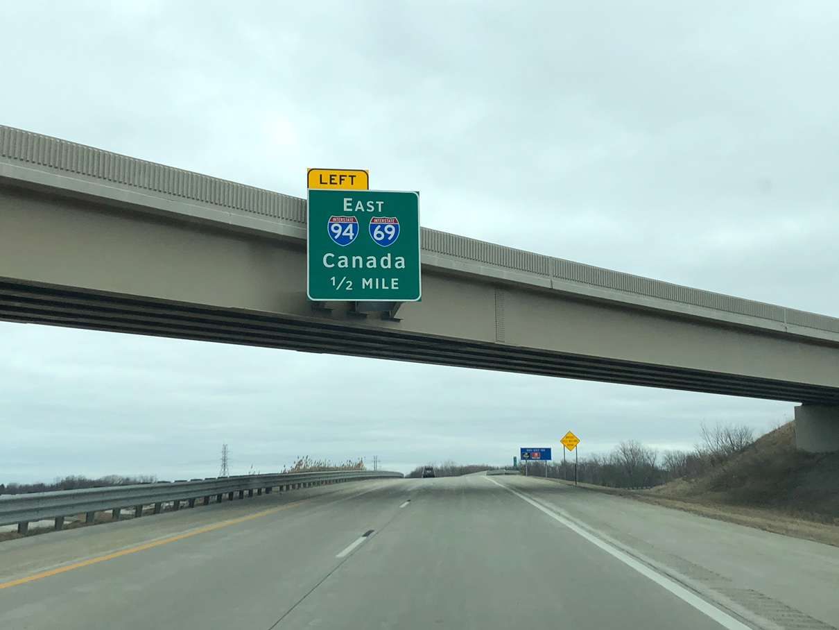
I-69/94 combine east within the wye interchange (Exit 199) at Business Loop I-69 to the freeway conclusion at M-25 and the Blue Water Bridge into Canada. Photo by Peter Johnson (03/14/20).

Business Loop I-69 parallels I-69/94 to the south along the couplet of Oak and Griswold Streets while the freeway proceeds east toward Sarnia, Ontario. Photo by Peter Johnson (03/14/20).

Heading east from the Lapeer Connector and Water Street (Exit 274), a new bridge was built for I-69/94 over the Black River during 2011-12 construction. Exit 275 follows for M-25 (Pine Grove Avenue, the former route of U.S. 25 until 1972. Photo by Peter Johnson (03/14/20).

A freeway ends sign precedes the Bluewater Bridge toll plaza, which lies between M-25 and 10th Avenue. Photo by Peter Johnson (03/14/20).

The Blue Water Bridge spans the St. Clair River with a maximum of three lanes in each direction. Lane signals regulate traffic flow. Photo by R. Bruce Telfeyan (07/24/04).

A plaque marks the International boundary between the United States and Canada at the mid point of the Blue Water Bridge. King’s Highway 402 extends east from the tied arch bridge to Sarnia and London, Ontario. Photo by R. Bruce Telfeyan (07/24/04).


The Blue Water Bridge consists of two spans, a continuous tied arch bridge for eastbound traffic and a cantilever truss for westbound motorists. The original span was constructed following a ground breaking ceremony held on June 23, 1937 in the city of Port Huron. It opened to two-way traffic on October 10, 1938. The second bridge was built between June 1995 and July 1997. Upon completion, traffic from the 1937-span shifted onto the newly opened bridge, allowing for renovation of the original crossing. Westbound traffic fully shifted onto the rebuilt bridge in November 1999 (MDOT, n.d.). Photos by Eric Vander Yacht (05/01).
![]() South at
South at ![]()
![]()

A loop ramp connects M-25 (Pine Grove Avenue) south with the Blue Water Bridge from just north of Elmwood Street. M-25 formally ends a block to the north while historic U.S. 25 continues south into Downtown Port Huron. Photo by Jeff Morrison (06/25/07).
Historic East End –  – Flint, Michigan
![]() at
at ![]()
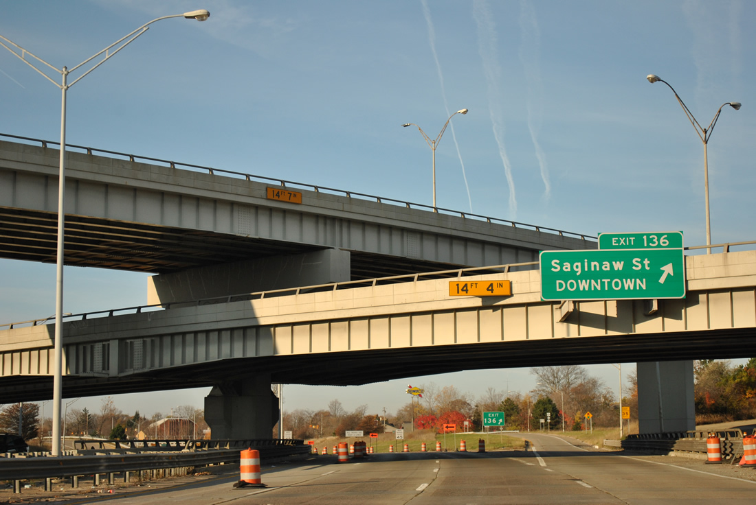
Interstate 69 previously began westbound at the exchange joining M-21 with I-475 (Exit 136). 11/06/11

I-69 eastbound concluded at I-475 just beyond the Beach Street overpass in Flint. Brackets visible here once supported overheads displaying signage with two M-21 shields and the control cities of Lapeer and Port Huron. A previous guide sign for I-475 only referenced Detroit, as the freeway north from I-69 was not completed before 1984. 11/06/09

I-69 east at the four level interchange with I-475 at Downtown Flint, where M-21 previously took over. Photo by Don Hargraves (11/02).
![]() at
at ![]()

Approaching I-69 on I-475 north. Prior to 1984, an overhead appeared here displaying “Highway Ends 3/4 Mile”. The sign for I-69 also displayed M-21. Photo by Don Hargraves (11/02).

I-475 north ended just beyond I-69/M-21 at Court Street (former M-56) until 1984. Photo by Don Hargraves (11/02).

I-475 south at the Court Street overpass and ramps for I-69 (Exit 6) at Downtown Flint. This stretch of Interstate 475 opened after the extension of I-69 east to Port Huron was posted. 11/05/09
Cardinal Direction Change – Lansing, Michigan

The north split of I-69/96. I-96 travels 55 miles west to Grand Rapids as I-69 straddles the north side of Lansing en route to Flint, 55 miles to the east. Photo by Don Hargraves (11/02).

Replaced overheads at the three wye interchange (Exit 91) where I-69/96 split. Omitted from new signage is Business Loop I-94, which follows Grand River Avenue east from Exit 90 into Lansing. 11/05/11

Confirming marker for Interstate 69 north posted beyond the separation with I-96 west. 11/05/11

The first shield for I-69 east, posted just after I-96 in Watertown Township. Photo by Don Hargraves (11/02).

Removed by June 11, 2002, this sign referenced the cardinal direction change along I-69. New signage posted along the I-69 north/96 west overlap around this time referenced I-69 as traveling east (D. Hargraves, personal communication, June 11, 2002). Photo by Eric Vander Yacht (05/01).

The last westbound shield for I-69 precedes the six mile overlap with I-96 east. 11/05/11

A guide sign originally stood along the curve taking I-69 westbound onto I-96 east displaying “I-69 west becomes I-69 south.” Photo by Don Hargraves (11/02).
South End – Indianapolis, Indiana
![]() South at
South at ![]() / Binford Boulevard
/ Binford Boulevard

Crossing over 82nd Street at Castleton, I-69/SR 37 advance south 0.75 miles to I-465 and Binford Boulevard. Photo by Thomas Decker (02/06/12).

The Interstate 69 mainline defaults onto Binford Boulevard (former SR 37) with two lanes. Expansion of the ramps to I-465 added a third lane at Exit 200 (former Exit 0). Photo by Thomas Decker (02/06/12).

Two lanes partition from I-69 south for I-465/SR 37 south along the east side of Indianapolis and I-465 west toward Carmel and Zionsville. Photo by Thomas Decker (02/06/12).

The freeway mainline from I-69 transitions onto Binford Boulevard at a signalized intersection with 75th Street. Binford Boulevard constitutes an at-grade arterial with near-expressway standards southwest into Downtown Indianapolis. 10/16/04
Binford Boulevard North at ![]()
![]()
![]()

Binford Boulevard progresses north from 71st Street one mile to the exchange joining I-69 with I-465. Photo by Brian Dowd (11/29/02).

Binford Boulevard intersects 75th Street just ahead of the freeway beginning of Interstate 69 north in Indianapolis. Photo by Brian Dowd (11/29/02).

I-69 commences north from Binford Boulevard through the directional cloverleaf interchange with Interstate 465. The ramp for I-465 is unnumbered in this direction. Photo by Brian Dowd (11/29/02).

Traffic loops onto I-465 west to the north side of Indianapolis. There is no access to I-465 south from Binford Boulevard. Photo by Brian Dowd (11/29/02).
![]()
![]() North at
North at ![]()

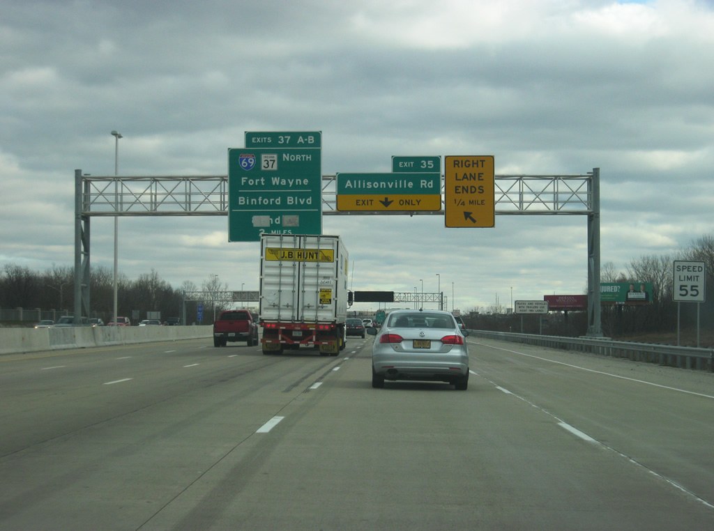
The first in a series of overheads for I-69 was removed when northbound I-465 was expanded to four lanes between May and November 2002. The forthcoming ramp was assigned Exit 37B, as Exit 37A was reserved for the unbuilt ramp to Binford Boulevard south. Photo by Brian Dowd (05/31/02).


Paralleling Shadeland Avenue across Fall Creek, I-465/SR 37 advances north 1.5 miles to Interstate 69. Photos by Chris and Amber Lokken (04/07/08).

Interstate 69 travels 22 miles northeast from Exit 37 to Anderson. Photo by Carter Buchanan (07/31/09).

Exit 37 departs with two lanes from Interstate 465 north to I-69/SR 37 north to Fishers, Fort Wayne and Lansing, Michigan. Photo by Carter Buchanan (07/31/09).
![]() East at
East at ![]()
![]()
Construction to widen I-465 east to the White River, two miles ahead of I-69/SR 37, was completed in 2011. Photo by Thomas Decker (12/17/11).
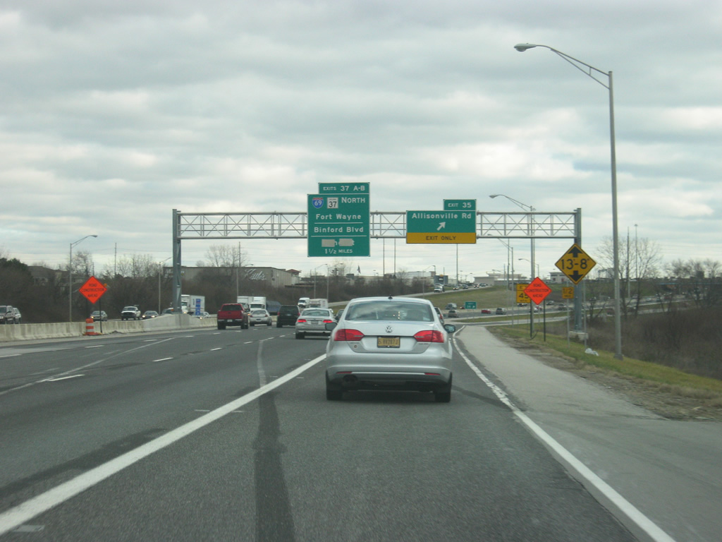
465/69 Northeast road work reconstructed Exit 35 with Allisonville Road into a single point urban interchange (SPUI) in 2012. Interstate 69 is the next exit. Photo by Thomas Decker (12/17/11).

Proposed changes at the directional cloverleaf interchange in the 465/69 Northeast project outlined a new high-speed flyover from I-465 east to I-69 north, with a c/d roadway northeast to the nearby East 82nd Street interchange. These upgrades did not progress as planned. Photo by Chris and Amber Lokken (06/23/08).

Exit 37A joins I-465 east with Binford Boulevard (former SR 37) south just ahead of I-69 north. When the state road was relocated from within the beltway in the late 1990s, its alignment was renamed Binford Boulevard. As part of the 1968 Indianapolis Transportation Plan, Binford Boulevard follows the planned route of the Northeast Freeway to Falls Creek Parkway. Photo by Chris and Amber Lokken (06/23/08).

Exit 37B loops onto I-69/SR 37 north to Fishers. Interstate 69 joins Indianapolis with Fort Wayne and Lansing, Michigan. Photo by Chris and Amber Lokken (06/23/08).
References
Federal Highway Administration (FHWA). (2012, September 14). Corridor: Interstate 69 (I-69) Texas to Michigan. [Press release]. https://www.fhwa.dot.gov/pressroom/fsi69.cfm
Flint Freeway Finished Dec. 21. (1971, December 4). The Owosso Argus-Press.
Rook, C. (2006, July 23). Interstate roads have shaped the future for many mid-Michigan communities. Lansing State Journal.
SH 44 Added to Congressionally Designated I-69 Corridor. (2015, December 5). Alliance for I-69 Texas. Retrieved November 11, 2025 from https://www.i69texasalliance.com/NewsUpdates/update 12.5.2015 sh44.html
Michigan Department of Transportation (MDOT). (n.d.). Blue Water Bridge history. MDOT. https://www.michigan.gov/mdot/programs/bridges-and-structures/blue-water-bridge/history
Kunz, L. (2011, October 26). Governor unveils first I-69 corridor. (2011, September 2). The Messenger (Madisonville, KY).
TBKS1 [username]. (2025, October 27). Re: I-69 in AR (and Pine Bluff I-69 Connector/AR 530). [Online forum post]. AARoads Forum. https://www.aaroads.com/forum/index.php?topic=3524.msg3010001#msg3010001
Risher, W. (2006, October 2). Road to Riches: DeSoto, region expected to reap major benefits of highway. Memphis Commercial-Appeal.
State Route 690 opens for travelers in Obion County. (2024, February 21). WBBJ. Retrieved November 11, 2025, from https://www.wbbjtv.com/2024/02/21/state-route-690-opens-for-travelers-in-obion-county/
Heller, M. (2025, March 21). TDOT extends public comment period on I-69 Interchange Re-configuration Project. KFVS. https://www.kfvs12.com/2025/03/21/tdot-extends-public-comment-period-i-69-interchange-re-configuration-project/
ITB [username]. (2018, December 12). Re: Update on I-69 Extension in Indiana. [Online forum post]. AARoads Forum. https://www.aaroads.com/forum/index.php?topic=3524.msg3010001#msg3010001
Paving begins on Interstate 69 in Obion County. (2021, July 13). WBBJ. Retrieved November 11, 2025 from https://www.wbbjtv.com/2021/07/13/paving-begins-on-interstate-69-in-obion-county/
ITB [username]. (2019, April 19). Re: Update on I-69 Extension in Indiana. [Online forum post]. AARoads Forum. https://www.aaroads.com/forum/index.php?topic=3524.msg3010001#msg3010001
Latek, T. (2024, December 24). 55 miles of Ky. parkways accepted into Interstate Highway System following recent upgrades. Kentucky Today. https://www.kentuckytoday.com/news/55-miles-of-ky-parkways-accepted-into-interstate-highway-system-following-recent-upgrades/article_4fadc312-c152-11ef-9b4c-1759f32e123a.html
KYDOT District Engineer Presents Road Work Updates. (2013, October 17). SurfKY News Media.
Stretch of Pennyrile Parkway in Western Kentucky upgraded to I-69. (2015, November 16). The Lane Report. Retrieved November 11, 2025 from https://www.lanereport.com/57079/2015/11/stretch-of-pennyrile-parkway-in-western-kentucky-upgraded-to-i-69/
Office of Governor Andy Beshear. (2025, November 3). Gov. Beshear Joins Officials To Mark Completion of ORX Section
1 and Opening of New Roadway in Henderson. [Press release]. https://transportation.ky.gov/NewsRoom/Gov. Beshear Marks Opening of ORX Section 1.pdf
Study says tolls alone couldn’t pay for I-69 bridge project State says a variety of funding options needed. (2008, July 16). Owensboro Messenger-Inquirer.
INDOT: Next section of I-69 to open by end of year. (2015, May 26). Evansville Courier & Press.
Reschke, M. (2016, April 13). I-69 Section 5 completion delayed to June 2017. The Herald-Times. https://www.heraldtimesonline.com/story/news/local/2016/04/13/i-69-section-5-completion-delayed-to-june-2017/47901945/
I-69 Section 5 project pushed back again. (2016, September 21). Evansville Courier & Press.
Drivers will be able to go 70 mph on I-69 from Martinsville to Bloomington starting Monday. (2018, October 13). Fox 59. Retrieved November 11, 2025 from https://fox59.com/news/drivers-will-be-able-to-drive-70-mph-on-i-69-from-martinsville-to-bloomington-starting-monday/
Hren, J. (2018, October 30). INDOT: I-69 Section 5 Is ‘Substantially Complete’. Indiana Public Media. https://www.ipm.org/2018-10-30/indot-i-69-section-5-is-substantially-complete
Reschke, M. (2018, October 30). Traffic Tuesday: I-69 Section 5 substantially complete. The Herald-Times. https://www.heraldtimesonline.com/story/news/local/2018/10/30/raffic-tuesday-i-69-section-5-substantially-complete/46861617/
Indiana pays over $184M for properties along I-69 route. (2016, April 13). News-Sentinel.
Indiana Department of Transportation (INDOT). (2020, January 7). $164 million contract to build I-69 in Martinsville. INDOT. https://i69finishline.com/164-million-contract-to-build-i-69-in-martinsville/
Indiana Department of Transportation (INDOT). (2021, December 20). Gov. Holcomb, INDOT, state and local officials open new section of I-69 in Martinsville INDOT. https://i69finishline.com/gov-holcomb-indot-state-and-local-officials-open-new-section-of-i-69-in-martinsville/
Indiana Department of Transportation (INDOT). (2021, December 23). I-69 in Martinsville opens to through traffic in both directions. INDOT. https://i69finishline.com/i-69-in-martinsville-opens-to-through-traffic-in-both-directions/
Indiana Department of Transportation (INDOT). (2022, May 31). New I-69 portion opens to traffic tonight, two stoplights to be removed. INDOT. https://i69finishline.com/new-i-69-portion-opens-to-traffic-tonight-two-stoplights-to-be-removed/
Bonilla Muñiz, L. (2024, August 6). ‘Decades in the making’: Indiana to unveil last stretch of I-69. Indiana Capital Chronicle. https://indianacapitalchronicle.com/2024/08/06/decades-in-the-making-indiana-to-unveil-last-stretch-of-i-69/
Page updated November 12, 2025.