Interstate 465 Indiana

Overview
Interstate 465 is a complete beltway encircling much of Indianapolis, Indiana. The freeway is mostly suburban, with major widening projects undertaken along the East Side in the late 90s and early 2000s and along the West Side (Accelerate465) between 2009-2012. With expansion up to eight lanes, reconstruction also modernized the freeway in both the Park 100 and the Allisonville / Castleton areas.
All U.S. highways and state roads were removed from surface streets within the Indianapolis Beltway over the course of the 1980s and 90s. This created a numbering headache as U.S. 31, U.S. 36, U.S. 40, U.S. 52, U.S. 421, SR 37 and SR 67 combine with the 53 mile long loop at some point. Overlapped routes are generally not marked however, with signs solely referencing either I-465 or I-74/465 along the south side of Indianapolis. Guide signs and trailblazers reference the continuation of each respective U.S. route or state road at the Beltway entry points.
Upon completion through Perry Township in 2024, Interstate 69 was cosigned along I-465 around the east side of the beltway. This includes the construction of a directional T interchange west of the exchange joining I-465 with SR 37 at Harding Street.
Route Information
North End – Indianapolis, IN
South End – Indianapolis, IN
Mileage – 52.73
Cities – Beecher Grove, Indianapolis, Lawrence, Speedway
- Junctions –


Source: December 31, 2021 Interstate Route Log and Finders List
I-465 Annual Average Daily Traffic (AADT)
 History
The circumferential route at Indianapolis was part of the original proposed Interstate system for Indiana approved on March 24, 1958. Interstate Route Number A65 applied to the beginning of the route at I-65 south of Indianapolis and running west and north to I-65 near U.S. 52 and 62nd Street. Interstate Route Number B65 represented the east and north side of the loop to I-65, near U.S. 52 north of 86th Street. The leg between I-65 adjacent to Eagle Creek Park and Zionsville was not included in the circumferential highway.
Interstate 465 was selected as the designation for the Indianapolis loop by the Indiana State Highway Department by August 8, 1958. The American Association of State Highway Officials (AASHO) approved the urban Interstate numerology for the state on November 12, 1958.
Interstate 465 superseded portions of Indiana State Road 100. SR 100 represented the original beltway along the East and West Sides of Indianapolis envisioned in the 1950s. Construction of the loop began in 1959 and the first segment opened to traffic in 1961. The entire I-465 loop was completed by 1970.1
I-465 did not directly replace all of SR 100, as a portion of the route remains along Shadeland Avenue. The expressway branches north from I-465 at Exit 48 to Warren Park. This segment was decommissioned as a state road in 1999.
Prior to 2002, Interstate 465 was also signed along the northwestern spur linking the Indianapolis Beltway at Zionsville with I-65 at Royalton. Locally known as the Dog Leg, the 4.72 mile long connector was renumbered as Interstate 865. Approved by the American Association of State Highway and Transportation Officials (AASHTO) on December 15, 2002, the change addressed motorist confusion and preceded completion of the Indianapolis Advance Traffic Management System (ATMS):
Over time this section of Interstate has been labeled by the media and the motoring public as the “I-465 Connector”, “I-465A” and the “465 dogleg”. This is the very source of confusion that we wish to correct.
 Photo Guides
North End  – Eagle Creek Park, Indianapolis, Indiana
![]() North at
North at ![]()

Two lanes depart by Eagle Creek Park at Left Exit 20 from I-465 north for Interstate 65 north to Traders Point in northwest Indianapolis, Lafayette and Gary. 11/05/09
![]() South at
South at ![]()

A loop ramp joins southbound Interstate 465 with I-65 south at Exit 20. 06/25/22

I-65 angles 17 miles southeast through Downtown Indianapolis between the two exchanges with the beltway. I-465 advances south four miles to combine with Interstate 74 east at Speedway. Photo by Thomas Decker (12/17/11).
![]() North at
North at ![]()

Interstate 65 converges with I-465 one mile north of the 52nd Street overpass. Photo by Brian Dowd (11/29/02).

Lafayette Road (old U.S. 52) runs along the east side of I-65 leading to the partial exchange with Interstate 465. There is no connection to the beltway southbound at forthcoming Exit 123. Photo by Brian Dowd (11/29/02).

Exit 123 links Interstate 65 northbound with I-465 north to Park 100 and Carmel. 11/05/09
![]() South at
South at ![]()

A wye interchange links Interstate 65 southbound with I-465 south at Exit 123. I-465 leads south from Eagle Creek Park to Speedway and Interstate 70 by Indianapolis International Airport (IND). Photo by Thomas Decker (05/14/12).
 North End Throwback


Interstate 465 at the partial exchange with I-65 prior to the Accelerate 465 reconstruction. Photos by Brian Dowd 05/31/02, 06/02/02 and 11/29/02.
South End / Zero Milepost – Indianapolis, Indiana
![]()
![]() East at
East at ![]()

These button copy signs for Interstate 65 remained in service along I-74/465 east into 2018. Photo by Thomas Decker (12/17/11).

Keystone Avenue spans I-74/465 a half mile west of the the directional cloverleaf interchange (Exit 53) with Interstate 65. Photo by Thomas Decker (12/17/11).

Interstate 65 leads north into Downtown Indianapolis and south to Columbus and Louisville, Kentucky. Photo by Thomas Decker (12/17/11).

A loop ramp links I-74/465 east with I-65 north at Exit 53B. A $19.6 million project rebuilt six spans at this exchange, including the I-65 mainline. Work finished in November 2017 after nine months.2 Photo by Brian Dowd (05/31/02).
![]()
![]() West at
West at ![]()

I-74/465 wrap around the southeast side of Beech Grove to the SPUI (Exit 52) with Emerson Avenue. The exchange with Interstate 65 follows in 1.5 miles. 11/05/09

Exit 52 leaves the Indianapolis Beltway west for Emerson Avenue at Beech Grove. Forthcoming Exit 53 links I-74/465 with I-65 north by the University of Indianapolis to Downtown and south 100 miles to Jeffersonville. 11/05/09
![]() South at
South at ![]()
![]()
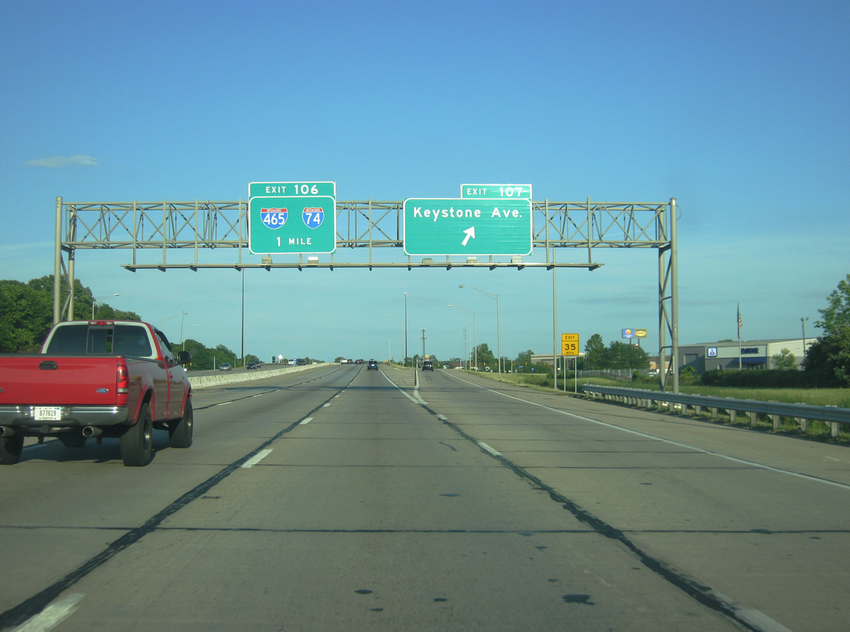
Passing through the diamond interchange (Exit 107) with Keystone Avenue, one mile ahead of I-74/465 on I-65 south. Photo by Thomas Decker (05/14/12).

An auxiliary lane opens from the Keystone Avenue entrance ramp to Exit 106 with I-74/465. Photo by Thomas Decker (05/14/12).

All traffic for the Indianapolis Beltway departs in unison at Exit 105 for the I-74/465 overlap west to Speedway and east to Beech Grove and Five Points. Photo by Thomas Decker (05/14/12).

Traffic partitions from Interstate 65 south for westbound I-74/465 to the West Side of Indianapolis and Crawfordsville and eastbound to Lawrence and Cincinnati, Ohio. Photo by Thomas Decker (05/14/12).
![]() North at
North at ![]()
![]()

Former overheads at the Edgewood Avenue overpass for I-74/465 (Exit 106). A new sign bridge was added here during 2014-15 widening of I-65 to eight lanes here. Sound walls were also installed. Photo by Chris and Amber Lokken (01/31/10).

The speed limit reduces to 55 miles per hour leading to the Indianapolis Beltway (Exit 106). The Highgate subdivision was developed in the formerly vacant land east of Interstate 65 here in 2018. Photo by Chris and Amber Lokken (01/31/10).

A lane drop occurs along I-65 north for I-74/465 east at Exit 106. Arrow per lane (APL) signs were added ahead of the old button copy overhead at Thompson Road during the 2014-15 freeway expansion. Photo by Chris and Amber Lokken (01/31/10).

Exit 106 separates from Interstate 65 north for I-74 and I-465 six miles south of Downtown Indianapolis. I-74 circumvents the city center along I-465 west to Speedway and east to Five Points. Photo by Chris and Amber Lokken (01/31/10).

Exit 106 splits into ramps for the Beltway west nine miles to Interstate 70 near Indianapolis International Airport (IND) and east through the city of Beech Grove. The ramp for I-74/465 was expanded to two lanes. Photo by Chris and Amber Lokken (04/07/08).
Sources:
- I-465. Indiana Highway Ends. http://www.highwayexplorer.com/EndsPage.php?id=3465§ion=1
- Indiana Department of Transportation (INDOT). (2019, February 6). Rebuilding Six I-65 Bridges at I-465 South. https://www.in.gov/indot/about-indot/central-office/welcome-to-the-greenfield-district/rebuilding-six-i-65-bridges-at-i-465-south/
Page updated June 27, 2022.