Interstate 71


Just prior to the northern end at the Tremont neighborhood in Cleveland, the northbound lanes of Interstate 71 form a double-deck freeway with the ending SR 176 north. The southbound lanes of both freeways travel at-grade nearby. Photo by Steve Hanudel (06/18/06).
Overview
Originating in Louisville, Kentucky, Interstate 71 travels northeast to Cincinnati, Columbus and Cleveland in Ohio. I-71 has more miles to the east of Interstate 75 than it does to the west of I-75.
The route of I-71 through northern Kentucky takes the freeway across hilly terrain to the south of the Ohio River. Wide medians and steep hillsides are encountered along the route. One such stretch in Carroll County, south of the Kentucky River, is where a tragic bus crash occurred on May 14, 1988. 27 people died when a wrong way drunk driver collided with a church bus. Signs are posted at the site in each direction.
North of Walton, I-71/75 combine through the south suburbs of Cincinnati through Florence, Erlanger and Fort Mitchell. The pair reach urban Covington and cross the Ohio River along the double decked Brent Spence Bridge. Future construction along the Brent Spence Bridge Corridor will add a second span adjacent to the cantilever bridge opened in 1963. The preferred alternative for the companion span to the west was approved in 2012. It will separate local and through traffic while expanding capacity.
Within the Buckeye State, Interstate 71 turns east between the Ohio Riverfront and Downtown Cincinnati along Fort Washington Way before curving northward through Lytle Tunnel along a winding route to Norwood, Kenwood and Blue Ash. Leaving the Cincinnati suburbs, I-71 turns easterly again across a mixture of agricultural and forest land toward the Columbus metropolitan area.
Entering the suburbs of Columbus at Grove City, Interstate 71 curves northward to parallel the Scioto River ahead of Downtown. The freeway combines with I-70 across the river along the southern periphery of the central business district before resuming a northward course to the east of Downtown. This stretch is slated for improvements due to the weaving traffic patterns of the I-71 mainline. Interstate 71 otherwise continues north through the capital city to exit it near Worthington and Westerville.
Beyond Columbus, Interstate 71 transitions back into a rural freeway north to Berkshire where it bends northeast for the Cleveland area. Bypassing Mansfield to the east, I-71 traverses a swampy area by Charles Mill Lake ahead of Ashland. Remaining rural, the freeway extends northeast to meet the west end of I-76 near Westfield Center and south end of I-271 outside Medina.
The outer suburbs of Cleveland ensue along the northward drive by Brunswick and Strongsville, with I-71 passing by Cleveland-Hopkins International Airport (CLE) along an increasingly urban route at Brook Park. The final stretch of I-71 takes the route east from the airport area through west Cleveland and northern Brooklyn. The route overtakes the north end of the Jennings Freeway (State Route 176) before ending at I-90 and I-490 and the Innerbelt.
High Priority Corridor
Interstate 71 in Ohio is part of High Priority Corridor 78.
 Parallel U.S. Routes
Interstate 71 largely follows U.S. 42 from Louisville to Cleveland. U.S. 25 and U.S. 127 tie into the corridor where I-71 overlaps with I-75, and U.S. 22 parallels I-71 northeast from Cincinnati to Wilmington in Ohio. North from Wilmington, U.S. 62 accompanies the freeway corridor into Downtown Columbus, where U.S. 23 ties in and runs just west of I-71 to Orange.
Major Projects
Kentucky
Within Louisville, Kentucky, major improvements and upgrades were completed at the “Spaghetti Junction” (Kennedy Interchange) between I-64, I-65, and I-71 as part of the larger Ohio River Bridge Project. The new Abraham Lincoln Bridge opened for Interstate 65 across the Ohio River on December 6, 2015. It carries northbound traffic to Jeffersonville, Indiana, previously accommodating both directions of I-65 during reconstruction of the adjacent John F. Kennedy Memorial Bridge for southbound traffic. The exchange at the south end of the crossing was redesigned to better connect the three Interstates. Work included extended ramps linking the bridges with Interstate 71 independent of the I-64 mainline. This eliminated weaving traffic patterns and conflict points. Construction commenced on the Downtown Crossing project in July 2013. Work ran through 2016.1
Route Information
Mileage
Kentucky – 97.42*
Cities – Louisville, Covington
Junctions –


Ohio – 248.02**
Cities – Cincinnati, Columbus, Mansfield, Cleveland
Junctions –
Source: December 31, 2021 Interstate Route Log and Finders List
* – 19.70 miles on I-75
** – 0.13 miles on I-75, 1.34 miles on I-70
June 18, 2025 Ohio Department of Transportation (ODOT) Straight Line Diagrams

The stretch of Interstate 71 between Norwood and Kenwood, Ohio opened to traffic in 1973. The remaining freeway through Cincinnati was completed by 1975.4

The initial route of I-71 through Columbus took the freeway along the west and north sides of Downtown. The west and north legs of the Columbus Innerbelt also doubled as I-70A officially until the American Association of State Highway and Transportation Officials (AASHTO) eliminated the designation on November 10, 1973. I-71 was dropped from this alignment in 1976.4

Interstate 90 proposed along the Parma Freeway leading north from I-80N to the Cleveland Memorial Shoreway. Had this been built, I-71 would have traveled along the Innerbelt Freeway north to the Shoreway.
Ohio
Within Columbus, the Ohio Department of Transportation (ODOT) previously proposed a pair of plans to deal with worsening congestion in Downtown. One option was to reroute Interstate 70 south of its current alignment between Exit 98/U.S. 42 and near Milepost 106. Presented in November 2003, another option proposed separating through traffic on I-70/71 from traffic bound for Downtown. The I-70/I-71 South Innerbelt Corridor Study was developed between 2002 and 2004. It resulted in three possible alternatives with the addition of collector distributor lanes or streets. Potential construction would begin in 2008 and conclude in late 2010. Design of the project commenced in 2005.2
Renamed the Columbus Crossroads project and then the I-70/I-71 Downtown Ramp Up mega project, work to unravel the weave of I-70 and I-71 was packaged in the larger $1.4 billion umbrella of projects that included rebuilding the junction between I-71 and Interstate 670 to the north. The I-670 project (Phase 1) was completed in November 2013 as were subsections of Phase 2 including the Africentric School retaining wall, the Mound Street Connector and the 18th Street Bridge. The remainder of Phase 2, including work at the east junction between I-70 and 71 (Project 2D – East Interchange), was scheduled to start in 2017, but a lack of funding in 2016 for the $166 million project pushed this back to 2018.3 Costing an estimated $246 million, Phase 4B (I-70/71 South Innerbelt) is anticipated for construction from Fall 2023 to Fall 2026.
History
The Kentucky portion of Interstate 71 was built between November 1965 and July 1969.4
Interstate 71 in Ohio was established in 1962; the freeway was completed through the state by 1975. I-71 combines with Interstate 75 across the Brent Spence Bridge, a cantilever bridge with a double deck linking Covington, Kentucky with Downtown Cincinnati. Maintained by the Kentucky Transportation Cabinet (KTYC), both decks of the Brent Spence Bridge were reconfigured in 1985 from three 12 foot lanes with five foot shoulders to four 11 foot lanes with one foot shoulders. The two Interstates partition at the north end of the span, with I-71 joining U.S. 50 (Fort Washington Way) east along a below grade freeway.
Fort Washington Way was incorporated in the 1940s Metropolitan Master Plan for Cincinnati and constructed from 1959 to July 1961.6 The trenched freeway was designed with split roadways, a number of left exit ramps and curved portions along I-71 southbound. The city of Cincinnati outlined Fort Washington Way 2000 to rebuild the freeway and incorporated the project as part of new plan for the Cincinnati Riverfront {Renaissance on the River). The city commissioned the Ohio-Kentucky-Indiana Regional Council of Governments (OKI) to conduct a sub-corridor analysis for Fort Washington Way in 1995. The analysis was underway in January 1996, and a plan for reconstructing Fort Washington Way was produced by OKI the following year. Design contracts were let by September 1997, with the state of Ohio committing $80 million in project funding the next month.7
Reconstruction of Fort Washington Way commenced on July 2, 1998, with the first section of new roadway opened in October 1999. The remainder of the freeway was completed and opened to traffic in August 2000. A formal dedication for the project took place on December 20, 2000, while final paving work for the $313 million project continued until June 2001.8 The resulting work realigned the mainline so that both roadways of I-71 ran side by side and eliminated all left exit ramps. 27 new bridges were constructed along with new ramps from the Brent Spence Bridge east to 2nd Street. Work reconstructed the Third Street Viaduct and 3rd Street along I-71 into a landscaped boulevard. 2nd Street was also built as a landscaped boulevard along the south side of Fort Washington Way.7
Within Columbus, I-71 originally included portions of Interstate 670 north of Downtown and the freeway along State Route 315 west of Downtown. That dual configuration between that alignment and the route along I-70 and east of Downtown was removed in 1976.5

Northward in Cleveland, early Interstate proposals extended Interstate 71 along the Innerbelt Freeway to State Route 2 (Cleveland Memorial Shoreway), which was the original route slated for I-90. I-90 was proposed to run north along the unconstructed Parma Freeway from the Northwest Freeway at W 65th Street to Cleveland Memorial Shoreway at the 49th Street interchange. The Shoreway would then take I-90 east by Downtown to the current Dead Man’s Curve where the Innerbelt Freeway and SR 2 meet today. The cancellation of the Parma freeway led to the realignment of I-90 east onto the Innerbelt Freeway over what was previously proposed as an alignment of I-80N and later I-290. This alignment appears on the 1961 Ohio Official Highway map and on the following Cleveland city map from 1966:
North End  – Cleveland, Ohio
![]() West at
West at ![]()
![]()

Interstate 490 travels a short distance west from I-77 at the North Broadway neighborhood to I-71 south and I-90 west at Tremont. There is no access to I-90 (Innerbelt) east in this direction. 06/14/10

Traffic partitions with two lanes leading to I-90 (Northwest Freeway) west to Lorain and the Ohio Turnpike for Toledo and two lanes for Interstate 71 south to SR 176 (Jennings Freeway) for Parma and Columbus. 06/14/10

Interstate 490 runs along the north side of Tremont Park as it enters the four-level interchange with I-71 (Medina Freeway) south. 06/14/10
![]() North at
North at ![]()
![]()

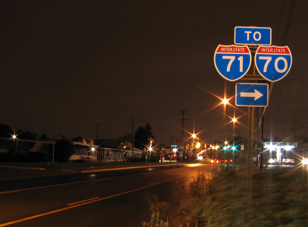
Interstate 71 north enters a wye interchange with SR 176 (Jennings Freeway), with two lanes continuing to I-90 east and a lane drop for a c/d roadway with the ending Jennings Freeway to I-90 (Northwest Freeway) west and I-490 east. Photo by Eric Stuve (07/02/17).

Interstate 71 north travels on a viaduct directly over the northbound lanes of the Jennings Freeway to Exit 247A with W 14th Street and the c/d roadway for I-90 and I-490. Photo by Eric Stuve (07/02/17).

The I-71 mainline defaults onto I-90 (Innerbelt Freeway) east to Downtown. Multi-year construction starting in 2011 replaced the Innerbelt viaduct over the Cuyahoga River. The work included revisions to ramps with U.S. 422/SR 14, E 9th Street and I-77 south. Photo by Eric Stuve (07/02/17).
![]() West at
West at ![]()

Interstate 90 advances south across the George V. Voinovich Bridge over the Cuyahoga River from I-77 to Left Exit 170B for I-71. Photo by Eric Stuve (10/15/17).

One half mile north of the four level interchange (Exit 170B) joining I-90 west with I-71/490. There is no access to I-490 east from I-90 west. Photo by Eric Stuve (10/15/17).

Traffic partitions with three lanes forming the southbound beginning of Interstate 71 toward the capital city of Columbus as I-90 turns west en route to the suburbs of Lakewood and Rocky River. Photo by Eric Stuve (10/15/17).

I-71 (Medina Freeway) runs alongs the highest level of the exchange with I-90 west and I-490 east. I-71 extends the Innerbelt Freeway south to SR 176 (Jennings Freeway). Photo by Eric Stuve (10/15/17).
![]() East at
East at ![]()
![]()

Passing through the split diamond interchange (Exit 169) with W 41st and W 44th Streets at Detroit-Shoreway, I-90 (Northwest Freeway) east is one mile ahead of Exit 170B for I-71 (Medina Freeway) south and Exit 170C for I-490 east. 09/30/10

Exit 170 departs I-90 east next for U.S. 42 (W 25th Street) for the Ohio City Near West Side community. Exit 170B follows for both Interstate 71 (Medina Freeway) south toward Columbus and SR 176 (Jennings Freeway) south to Brooklyn Heights and Parma. 09/30/10

Interstate 90 turns north onto the Innerbelt Freeway in one half mile as I-490 east begins. I-490 east provides the default movement from I-90 to I-77 as direct access from the Innerbelt to Interstate 77 south was removed in April 2011. 09/30/10

Exit 170B for I-71 south departs from the ramp carrying Interstate 90 east from the Northwest Freeway to the Innerbelt Freeway. A four-level interchange joins the two routes with I-490 and the Medina Freeway. 09/30/10

Interstate 490 extends east from the Northwest Freeway through Tremont to I-77 and the Opportunity Corridor to Kinsman and University Circle. 09/30/10

Exit 170B from I-90 east forms a distributor roadway separate from the Medina Freeway mainline to the wye interchange (Exit 246) with SR 176. The Jennings Freeway stems south through Brooklyn Center and Old Brooklyn to connect I-71 with I-480. 09/30/10
North End Throwback
![]() North at
North at ![]()
![]()

1.5 miles from the exchange (Exit 247B) with I-90 west and I-490 east. Photo by Tim Kubat (April 2006).

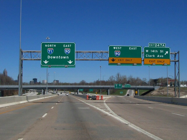
The c/d roadway from U.S. 42 returns as I-71 curves northeast to Exit 247A with W 14th Street, Clark Avenue and Steelyard Drive. Photo by Tim Kubat (April 2006).
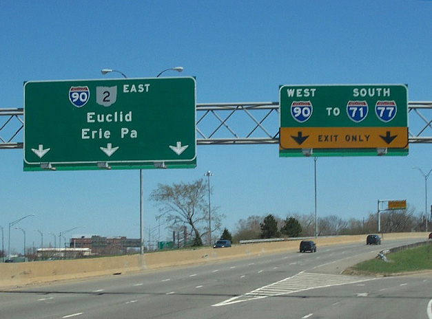
The c/d roadway at Exit 247A partitions into ramps for Interstates 90 (Northwest Freeway) west to the Detroit-Shoreway and Cudell neighborhoods of west Cleveland and I-490 east to I-77 and North Broadway. Photo by Tim Kubat (April 2006).

These button copy signs remained in service until at least 2009. Multi-year construction starting in 2011 replaced the Innerbelt viaduct over the Cuyahoga River. The work included revisions to ramps with U.S. 422/ SR 14, E 9th Street and I-77 south. Photo by Steve Hanudel (06/18/06).
![]() West at
West at ![]()

The original span leading south across the Cuyahoga River toward I-71 along I-90 was built in 1959. This span was replaced as part of the 2011-16 Innerbelt Project. 05/25/02

Crossing over the original Fairfield Avenue overpass, I-90 carried four lanes south with no shoulders to I-71. The Innerbelt Project shifted the lanes for I-90 just to the west of this scene. 05/25/02

Former button copy signs posted at the southbound beginning of Interstate 71. 05/25/02
Historic North End – – Cleveland, Ohio
![]() East at
East at ![]()

Heading north along the Innerbelt Freeway toward Cleveland Memorial Shoreway (SR 2) at the locally known “Dead Man’s Curve”, where a sharp ramp takes I-90 east onto SR 2 toward Bratenhal. Photo by Tim Kubat (April 2006).

A compact trumpet interchange sandwiches between a railroad line and Cleveland Burke Lakefront Airport (BKL). Several warning signs and a 35 MPH speed limit precede the nearly 90 degree turn of I-90 east. A loop ramp also departs here for SR 2 (Cleveland Memorial Shoreway) west toward Lakewood. Photo by Tim Kubat (April 2006).
![]() / Cleveland Memorial Shoreway – East at
/ Cleveland Memorial Shoreway – East at ![]()

Traveling east on State Route 2, the freeway approached the trumpet interchange with Interstate 90. Photo by Tim Kubat (April 2006).

SR 2 (Cleveland Memorial Shoreway) defaults onto Interstate 90 east toward Euclid as the Innerbelt Freeway takes I-90 west south to both I-71 and I-77. Photo by Tim Kubat (April 2006).
Interstate 90 combines with SR 2 for 10.6 miles along the Lakeland Freeway to Euclid. I-90 west overtook the northernmost 3.5 miles of I-71. Photo by Tim Kubat (April 2006).
South End – Louisville, Kentucky
![]() South at
South at ![]()
![]()

Interstate 71 remains a four lane freeway southwest from I-264 (Watterson Expressway) to Exit 1A/B for I-64/65. 09/08/20

I-71 crosses Beargrass Creek a half mile from Exit 1A for Interstate 64 west. 09/08/20

A pair of end Interstate 71 shields precede the partition of Exits 1A and 1B. 09/08/20

Interstate 64 enters the exchange with I-71 and I-65 from the southeast, paralleling the Ohio River as it navigates through Downtown en route to New Albany, Indiana. 09/08/20

The Big Four, Abraham Lincoln and John F. Kennedy Memorial Bridges span the Ohio River north of I-64 beyond milepost zero for Interstate 71. 09/08/20

Exit 1B for I-65 south toward Elizabethtown and Exit 1C for the tolled Abraham Lincoln Bridge north to Jeffersonville, Indiana separate above the Witherspoon Street underpass. 09/08/20
![]() east at
east at ![]()

Interstate 64 lowers from an elevated roadway adjacent to the Ohio River leading into the systems interchange with I-65 and I-71. Two lanes split for Interstate 71 beyond the left exit ramps for I-65. 09/08/20

Interstate 64 weaves east between ramps joining I-65 with I-71 toward the wye interchange (Exit 6) with Interstate 71 north toward Cincinnati, Ohio. 09/08/20

Exit 6 leaves I-64 east beside Lynn Family Stadium for Interstate 71 north ahead of Louisville Champions Park and the Clifton Heights neighborhood. 09/08/20
![]() North at
North at ![]()
![]()


I-65 (Dr. Martin Luther King, Jr. Expressway) navigates through an elevated S-curve from Downtown Louisville to the multi level interchange (Exit 137) with I-64 and I-71 north. 09/07/20

Merging with the entrance ramp from U.S. 31E/60 (Liberty Street) east, Exit 137 expands to four lanes along a c/d roadway north to the Abraham Lincoln Bridge taking Interstate 65 across the Ohio River. 09/07/20

Two lanes lower from the c/d roadway above U.S. 31E/60 (Main Street) west for I-64 east toward Lexington and I-71 north to Covington. 09/07/20
![]() South at
South at ![]()
![]()


Southbound Interstate 65 crosses the tolled John F. Kennedy Memorial Bridge over the Ohio River ahead of the exchange with I-64 and I-71 north. 09/08/20

Interstate 65 elevates along the Dr. Martin Luther King, Jr. Expressway through Downtown Louisville as ramps for I-64 west to Evansville, Indiana and I-64 east / I-71 north depart in unison. 09/08/20

Ramps from both directions of I-65 combine ahead of the separation for I-64 east to Frankfort and the northbound beginning of Interstate 71. 09/08/20

I-64 east and I-71 north combine with Interstate 75 at Lexington and Covington respectively. 09/08/20
South End Throwback
![]() South at
South at ![]()
![]()

Exit 1A departed I-71 south for Interstate 64 westbound to New Albany. Indiana and Saint Louis, Missouri. The mainline continued to I-65 (Dr. Martin Luther King, Jr. Expressway). Photo by Chris Patriarca (05/26/03).
![]() East at
East at ![]()

Interstate 64 emerged from the Kennedy Interchange ahead of Exit 6 for Interstate 71 north. Photo by Steve Hanudel (08/19/05).

Interstate 71 begins from I-64 at a wye interchange (Exit 6). Photo by Steve Hanudel (08/19/05).
![]() North at
North at ![]()
![]()

An arrow per lane (APL) sign replaced the first overhead for Exit 137 (I-64 and I-71 north) on Interstate 65 northbound at Muhammad Ali Boulevard (Exit 136C). Photo by Chris and Amber Lokken (01/31/10).

Reconstruction of the Kennedy Interchange shifted the separation with Exit 137 further south. Two lanes continue north across the tolled Abraham Lincoln Bridge now, with two connecting to I-64 and I-71 north. Photo by Chris and Amber Lokken (01/31/10).

The John F. Kennedy Memorial Bridge and Big Four Pedestrian Bridge came into view as Exit 137 departed Interstate 65 north for I-64 west to St. Louis, I-64 east to Lexington, and I-71 north to Cincinnati. Photo by Chris and Amber Lokken (01/31/10).
![]() South at
South at ![]()
![]()

One mile north of the Kennedy Interchange joining I-65 with I-64 and Interstate 71 north at Downtown Louisville. Photo by Chris Patriarca (05/26/03).


Crossing the Kentucky state line, I-65 southbound continued to a lane drop for I-64 west to Evansville, Indiana and I-64 east to Lexington. Photos by Chris Patriarca (05/26/03).


Upgrades at the Kennedy Interchange rebuilt both ramps to Interstate 64. The connection to I-64 east and I-71 north was expanded to two lanes. Photos by Chris Patriarca (05/26/03).

An elevated ramp replaced the previous roadway leading to I-64 east and I-71 north. Lexington lies 110 miles to the east, while I-71 reaches Cincinnati in 97 miles. Photo by Chris Patriarca (05/26/03).
Sources:
- Kentucky-Indiana Bridges.
http://www.kyinbridges.comproject web site. - “Plan takes I-70 out of Downtown.” Columbus Dispatch, February 7, 2004.
- “Next Phase of Interstate 70/71 Construction Delayed Until 2018.” Columbus Underground, April 12, 2016.
- KentuckyRoads.com – Interstate 71
- Route 71 – The Unofficial Ohio State Highways Web Site (John Simpson).
http://pages.prodigy.net/john.simpson/highways/071.html - “No Respect for Noble Roadway.” Cincinnati Post, The (OH), January 26, 2004.
- “Fort Washington Way 2000.”
https://www.cincinnati-oh.gov/ cityofcincinnati/cache/file/ AB5AAC2A-B843-495A-B160075D01C31C07.pdfcity of Cincinnati, online slide presentation. Accessed on September 26, 2016. - “Final paving to begin on Ft. Washington Way.” Cincinnati Post, The (OH), May 17, 2001.
Page updated June 3, 2022.