Interstate 26


Overview
Interstate 26 runs northerly from Charleston, South Carolina to a point just south of the Tennessee / Virginia State line near Kingsport. The route was extended northward twice from the original west end at Asheville, North Carolina, first in 2003 to I-81 and again in 2005 to U.S. 11W.
Interstate 26 begins in the Tri-Cities Region of Tennessee at U.S. 11W (W Stone Drive), which was the historic north end of I-181. I-26 overtook all of I-181 from Kingsport southward to Johnson City, and U.S. 23 from there to the North Carolina state line. This stretch includes a winding urban section through Johnson City, where U.S. 19W ties in from the northeast.
Angling southwest, I-26/U.S. 19W-23 travel through a valley between the Buffalo and Little Mountains to Erwin. Beyond there, the freeway climbs in elevation from south of Rich Mountain along the alignment opened in 2003, to the Bald Mountains and Sams Gap across the North Carolina border. Advancing southward, I-26 lowers through the Walnut Mountains to join an older stretch of freeway near Mars Hill.
U.S. 19 ties in from Radford Gap, joining I-26/U.S. 23 between Flat Creek and Weaverville, where U.S. 25/70 combine from the northwest. The five way overlap concludes near Downtown Asheville, with U.S. 25/70 departing for Interstate 240 east and U.S. 19/23 parting ways beyond the French Broad River (Bowen Bridge) to western reaches of the city.
I-26 and I-240 combine for 4.2 miles through West Asheville to meet Interstate 40 near Sand Hill. The exchange with I-40 was where I-26 used to begin. South from there, I-26 runs along an older freeway across the Blue Ridge Mountains to Hendersonville. U.S. 25 rejoins I-26 between Fletcher and East Flat Rock.
Beyond the split with U.S. 25 south, I-26 spans the Green River along the Peter Guice Memorial Bridge at a height of 225 feet. The freeway then winds eastward to Howard Gap and Columbus before entering the Palmetto State at Landrum.
Interstate 26 follows a southeasterly course throughout South Carolina. The freeway initially straddles western reaches of the Spartanburg area through the Upstate. South from there, I-26 combines with the end of I-385 from Greenville to traverse Sumter National Forest en route to Columbia. I-26 expands to six lanes at Irmo and proceeds through the capital city area to the “Malfunction Junction” cloverleaf interchange with I-20. Interstate 126 spurs east from nearby to Downtown Columbia while I-26 stays to the west by Cayce and Columbia Metropolitan Airport (CAE).
Continuing southeast, Interstate 26 next heads to Orangeburg before converging with I-95 at a rural cloverleaf interchange. Pine forest gives way to suburban development as the route passes by Summerville en route to Goose Creek, North Charleston and the junction with Interstate 526. The final stretch of I-26 winds through Charleston along an urban course south from the South Carolina Ports to U.S. 17 just north of Downtown.
 Parallel U.S. Routes
Interstate 26 parallels several U.S. routes on its course from the Tri-Cities area in Tennessee southeast to Charleston:
- Tri-Cities Area south to Asheville – U.S. 23
- Asheville south to Flat Rock – U.S. 25
- Flat Rock southeast to Spartanburg – U.S. 176
- Spartanburg south to Clinton – U.S. 221
- Clinton southeast to Columbia – U.S. 76
- Columbia southeast to Goose Creek – U.S. 176
- Goose Creek southeast to Charleston – U.S. 52 and U.S. 78
Interstate 26 Connector
Built in the 1960s, the freeway between Mars Hill and Rice Bend is substandard and remains signed as “Future Interstate 26” until upgrades are made. Additionally the interchange where I-26 and I-240 combine at Patton Avenue in Downtown Asheville includes sharp curves and single lane ramps. Adding to the traffic congestion here are the over capacity Smoky Park Bridges across the French Broad River. The Interstate 26 Connector, a new facility, was initially proposed to replace this stretch to meet 2025 forecast traffic counts.4

Built in 1968, the 1,315 foot long Smoky Park Bridges carry eight overall lanes of traffic, with auxiliary lanes running in each direction between Westgate Parkway / Patton Avenue and the Downtown interchange. The substandard bridges have no shoulders. 08/23/03
Funded for approximately $1.2 billion in the North Carolina Department of Transportation (NCDOT) State Transportation Improvement Program (STIP), the I-26 Connector project updates around seven miles of roads across four sections: Section A upgrades I-26/240 from the exchange with I-40 to U.S. 19-23 Business (Haywood Road). This includes upgrading interchanges at NC 191 (Brevard Road) and Amboy Road. Section B constructs a new alignment for I-26 from Haywood Road north across the French Broad River to U.S. 19/23/70 south of Broadway. Section C makes improvements along Interstate 40 at the interchanges with U.S. 19/23 (Smoky Park Highway), I-26/240 and NC 191 (Brevard Road). Section D improves Riverside Drive from Hill Street to Broadway Street in Asheville.
A Record of Decision for the project was approved in 2021 and right of way acquisition for Section A started in 2022. Construction on Section A commences in 2024.
Route Information
Tennessee – 54.45
Cities – Johnson City
- Junctions –

North Carolina – 52.69* (71.25)
Cities – Asheville, Hendersonville
- Junctions –

South Carolina – 220.95
Cities – Spartanburg, Clinton, Newberry, Columbia, Orangeburg, Goose Creek, Charleston
- Junctions –
Source: December 31, 2021 Interstate Route Log and Finders List
* – NC official mileage omits the segment of Future I-26.
I-26 Annual Average Daily Traffic (AADT)
| Location | Vehicles per day |
|---|---|
| south of Erwin, TN | 7,310 |
| Johnson City, TN | 60,503 |
| Kingsport, TN | 49,932 |
| Kingsport, TN | 24,661 |
Source: Tennessee Department of Transportation (TDOT) Transportation Data Management System 2021 AADT

Interstate 26 was open between Exit 115 (U.S. 21-176-321) and Exit 72 (S.C. 121 / old S.C. 19) and from Exit 15 (U.S. 176) to Exit 5 (S.C. 11) by 1960.

A 37 mile long stretch of Interstate 26 opened to traffic in South Carolina’s Low Country by late 1962. This extended the route southeast from U.S. 15 to U.S. 52/78 near North Charleston.

None of Interstate 26 appeared on the 1963 North Carolina Official Highway Map. The completed portions on the 1970 map appeared first on the 1967 edition. The last original segment was completed in 1976.9
An in depth look at all the alternatives for the I-26 Connector Project, including several options for the French Broad River crossing and exchange with I-240.
With the release of the state comprehensive transportation plan, the Interstate 26 Connector Project was delayed in April 2005. This plan pushed the completion date of the project back to 2012.6 Subsequent delays followed, further setting back the connector start date to 2024.
However $200 million in additional funding approved for the State Transportation Improvement Program in the North Carolina 2015-16 budget accelerated the time table for work on the I-26 Connector, between I-240 at Patton Avenue and West Asheville, to 2023. Work including the revamp of the I-26, I-40 and I-240 interchange advanced to 2021 while expansion of I-240 through West Asheville was slated for construction after 2025.10
A milestone was reached May 2016 when the North Carolina Department of Transportation (NCDOT) selected the preferred route for the I-26 Connector across the French Broad River. Alternative 4B of Section B takes I-26/240 on a new alignment across the French Broad River while improving its connections to Patton Avenue in West Asheville and the freeway along U.S. 19/23 near Downtown. This alternative also takes through traffic off the Jeff Bowen Bridge, allowing for the addition of pedestrian and bicycle facilities on the span.
Plans call for I-26/240 to leave Patton Avenue (Exit 3A) on a new alignment north and east across the French Broad River in a sweeping arc. I-26 will split from I-240 on a northeastward spoke while I-240 will curve back southeast to rejoin its current mainline at the existing exchange with U.S. 19/23 at Downtown. As a result of selecting this alternative, the I-26/240 concurrency will be extended by up to 0.7 miles and shift away from the Bowen Bridge, which local residents sought for years to remove from the Interstate system.16 The Bowen Bridge will be reconfigured for local traffic between Asheville and West Asheville. Project costs were estimated at $332 million, with construction potentially starting in late 2023 or 202417 and lasting for at least three years.16
History
South Carolina
Construction for Interstate 26 in South Carolina was well underway in 1959. The 204 miles from Landrum to Summerville was the longest continuous stretch of interstate highway under contract for construction at the time.11 Initial segments completed in South Carolina included a short stretch from U.S. 176 near Dodd Hill to S.C. 11 near Campobello. This section was finished in Spring 1960. Coupled with the freeway along U.S. 276 from Mauldin to Clinton, the remainder of I-26 south from Spartanburg to Columbia, opened by Fall 1960.12
Lengthening of Interstate 26 north into the Tarheel State occurred by October 15, 1964, when a five mile stretch opened to traffic between Campobello and Landrum, North Carolina.13
Interstate 26 was completed within the Palmetto State on February 25, 1969. Construction of the 221 mile long route in S.C. took 12 years and cost $118 million.14 The entire length of Interstate 26 in South Carolina was formally dedicated at a ceremony in Columbia on March 10, 1969.8
North Carolina
The first section of I-26 opened in North Carolina was the 14 mile long bypass of Hendersonville. A ribbon cutting ceremony led by State Highway Commissioner Joseph Hunt was held at the interchange with U.S. 64 on the morning of January 12, 1967. The freeway opened from U.S. 176 at East Flat Rock (Exit 7 on U.S. 25) north to Airport Road / Exit 40 at Arden. This included the two lane connector to U.S. 25 at Zirconia.15 Completion of the original section of I-26 between the state line and Asheville occurred on October 29, 1976 with the opening of the 7.5 mile long segment between Columbus and Saluda. The 40 miles of I-26 in North Carolina cost $54.1 million to build.14
Extension to Tennessee
First planned in 1987, the extension of Interstate 26 northward from Asheville to I-81 and I-181 near Fordtown, Tennessee allowed truck traffic that was banned on U.S. 19/23 a more efficient method to access I-81 to the north.1 The new nine mile long, six lane freeway opened from Mars Hill to the Tennessee state line on Tuesday August 5, 2003. Rising to a height of 4,000 feet above sea level,2 the final segment replaced a narrow, 11 mile long segment of U.S. 23 from Sams Gap southward to Mars Hill.1
Taking seven years to complete at a cost of $230 million, the Mars Hill to Sams Gap segment of Interstate 26 has no more than a six percent grade as compared to a nine percent grade on the old route of U.S. 23. The roadway features a 215 foot high bridge, high enough in the mountains to where engineers installed a de-icing system that can be activated by telephone. Additionally a fog detection system with warning lights was incorporated into the route as are three runaway truck ramps. Eighty percent of the funds to build the I-26 extension was derived from the Appalachian Regional Commission.3
It was anticipated that in addition to providing a new truck route to I-81, that the extended Interstate 26 would enhance local economies of the counties between Asheville and the Tri-Cities Region of Tennessee. Projections initially forecast a tripling of the traffic count at the state line by the year 2010, with up to 16,000 vehicles per day (vpd) predicted. Tennessee Department of Transportation (TDOT) traffic counts in 2014 however were just 7,430 vpd, down from 8,774 vpd recorded in 2010.
Interstate 26 north of Asheville was designated a Scenic Byway by the state of North Carolina. It was the first such Interstate in the Tarheel State to receive this distinction. On a clear day it is reported that one can see Mount Mitchell, the tallest peak of the Appalachian Mountain chain at 6,684 feet above sea level. Two scenic overlooks and a welcome center at the state line were constructed to enhance traveler’s experience when taking I-26.3

The Sams Gap Scenic Overlook along Interstate 26 during peak fall foliage season. The freeway winds north toward Little and Flint Mountains in this scene. 10/25/15
Efforts underway from 2003 through 2005 from local leaders in the city of Kingsport sought to extend Interstate 26 further north to the Virginia state line near Morrison City. The local chamber of commerce and other officials lobbied their congressional delegation and state legislators successfully in an effort to boost the local economy. As announced by U.S. Senators Bill Frist (R-TN) and Lamar Alexander (R-TN), and Representative Bill Jenkins (R-TN) as part of the Safe, Accountable, Flexible, and Efficient Transportation Equity Act: A Legacy for Users (SAFETEA-LU) highway bill, the I-26 extension received official approval on August 2, 2005.7
The I-26 extension superseded an alternate plan to renumber the remainder of Interstate 181 as “Interstate 126.” However with State Route 126 routed nearby in Kingsport, that plan never came to fruition due to the potential confusion of two similar numbers placed so closely.2
 Photo Guides
East End  – Charleston, South Carolina
![]() East at
East at ![]()

Exit 219B lowers from the Interstate 26 viaduct to Mt. Pleasant Street for King Street (U.S. 78), Meeting Street (U.S. 52) and Morrison Drive (unsigned U.S. 52 Spur). I-26 combines with U.S. 17 south next. 12/31/17

Eastbound Interstate 26 enters the Lucille S. Whipper Interchange (Exit 220) with U.S. 17 north across the Arthur Ravenel, Jr. Bridge and south toward Downtown Charleston. 12/31/17

A high flyover takes motorists onto the Ravenel Bridge (U.S. 17 northbound) east to Mount Pleasant as three lanes advance southward along I-26 toward Downtown Charleston. 12/31/17

Interstate 26 ends at the separation of Exit 221B to Meeting Street (U.S. 52 north) and the Charleston historic district and Exit 221A for the continuation of U.S. 17 along the Septima Clark Parkway west toward Downtown. 12/31/17
![]() North at
North at ![]()

U.S. 17 turns off Cannon Street onto Septima Clark Parkway at the Dr. Martin Luther King, Jr. Memorial District. Septima Clark Parkway takes the US route northeast to Interstate 26 west at Corning Street. 12/31/17

U.S. 17 (Septima Clark Parkway) transitions to Interstate 26 west along a viaduct elevating east from Coming Street. There is no direct access to King Street (U.S. 78 west) or Meeting Street as the freeway turns north to the Ravenel Bridge. 12/31/17
![]() South at
South at ![]()

U.S. 17 crosses the Cooper River via the Arthur Ravenel, Jr. Bridge. This eight lane, cable stay bridge connects Mount Pleasant with I-26 in central Charleston. 05/30/07

Succeeding ramps depart from the Ravenel Bridge westbound for Meeting Street (U.S. 52), Interstate 26 west and the continuation of U.S. 17 south to Downtown. 05/30/07

Departing first is the Morrison Drive / Bay Street off-ramp to the Port Terminals and the Aquarium of South Carolina. Collectively the two streets represent unsigned U.S. 52 Spur, which leads south to the historic Charleston Battery. 05/30/07

U.S. 17 turns south beyond the ramp for Meeting Street (U.S. 52) onto a flyover leading to Septima Clark Parkway. A single lane flyover connects with I-26 northwest to North Charleston and Columbia. 05/30/07
East End Throwback
![]() East at
East at ![]()

The end sign for Interstate 26 posted at Exit 219B was carbon copied onto a new sign bridge posted for the pending exchange with U.S. 17 and the Arthur Ravenel, Jr. Bridge. 01/18/04

Prior to completion of the high speed exchange with the Ravenel Bridge, Interstate 26 east continued uninterrupted to a directional T interchange with the Septima Clark Expressway (U.S. 17 between Downtown and the original Grace and Pearman Bridges). 01/18/04

I-26 east ended as two lane ramps partitioned for U.S. 17 (Septima Clark Expressway) south. Adjacent ramps connected with King Street (U.S. 78 north) and Meeting Street (U.S. 52 north). Both ramps remain in use, though Exit 221B serves only Meeting Street as Septima Clark Expressway east was dismantled along with Silas Pearman Bridge. 01/18/04

The previous ramp split of Exit 221B for U.S. 17 north to Mount Pleasant, and Meeting Street south to the Charleston historic district. U.S. 17 formerly traveled along a viaduct system from west of I-26 to the Pearman and Grace Bridges. 01/18/04

Exit 221A connected the east end of I-26 with King Street and the unmarked eastern terminus of U.S. 78. This ramp is no longer accessible to I-26, but remains in place for motorists taking U.S. 17 south from the Ravenel Bridge. Photo by Chris Patriarca (06/08/03).
![]() North at
North at ![]()

Trailblazers on a pedestrian bridge spanning U.S. 17 north remained from the original directional T interchange with I-26 west. These were finally removed by 2013 during a street scaping project to add palmetto trees and rebuild the sidewalk along Septima Clark Parkway. 05/30/07

The former separation of I-26 west from U.S. 17 north. The viaduct leading U.S. 17 east to the Grace and Pearman Bridges was subsequently dismantled following the July 15, 2005 opening of the Arthur Ravenel, Jr. Bridge. Photo by Chris Patriarca (06/08/03).
![]() South at
South at ![]()

U.S. 17 lowered from the John C. Grace Bridge to grade level briefly before elevating again above Meeting Street (U.S. 52 north), I-26 and a Norfolk Southern Railroad line. A southbound off-ramp departed for Meeting Street prior to the exchange with I-26 west. Photo by Chris Patriarca (06/10/03).

The original ramp from U.S. 17 (Septima Clark Expressway) south to I-26 west departed above Meeting Street. Prior signs referenced U.S. 52/78 for I-26 west. The two US highways parallel the freeway through North Charleston. Photo by Chris Patriarca (06/10/03).
Meeting Street at ![]()

Meeting Street north at the former interchange complex with I-26 west and U.S. 17. The northbound ramp for U.S. 17 passed under the Septima Clark Expressway viaduct before joining the left side of the Silas Pearman Bridge. A left turn restriction at forthcoming Lee Street required drivers on Meeting Street north to make a jug handle type movement to access I-26 west. Photo by Chris Patriarca (06/13/03).

The Meeting Street ramp split with a direct connection to U.S. 17 north and a U-turn ramp for Lee Street west to the I-26 westbound entrance ramp. Photo by Chris Patriarca (06/13/03).
West End  – Kingsport, Tennessee
![]() West
West ![]() North at
North at ![]()


Interstate 26 west / U.S. 23 south drop over 300 feet in elevation from Holston River Mountain to span the South Fork of the Holston River. A lengthy viaduct takes motorists north to U.S. 11W (West Stone Drive). 10/02/10, Peter Johnson (06/19/19).

Traffic to U.S. 11W (West Stone Drive) departs from I-26 west. U.S. 11W constitutes an arterial across the north side of Kingsport. Photo by Peter Johnson (06/19/19).


An end shield for Interstate 26 stands just beyond the six-ramp parclo interchange with U.S. 11W. U.S. 23 advances northward from milepost 0.0 to Norton, Virginia and Pikeville, Kentucky. Photos by Peter Johnson (06/19/19).
![]() South at
South at ![]()
![]()

U.S. 23 winds through suburban areas south from the Granby Road overpass toward U.S. 11W (W Stone Drive) and the beginning of Interstate 26 east. 10/02/10

U.S. 23 lowers through a valley from Bell Ridge at Exit 1 for U.S. 11W (W Stone Drive) at Fort Robinson in north Kingsport. Photo by Peter Johnson (03/27/21).

Passing over U.S. 11W (W Stone Drive), U.S. 23 south transitions into Interstate 26 as milepost zero appears. Photo by Peter Johnson (03/27/21).

A begin Interstate 26 shield was posted eastbound within the exchange at U.S. 11W (W Stone Drive) by 2007. Photo by Peter Johnson (03/27/21).

I-26/U.S. 23 lower across an elevated roadway spanning the Holston River South Fork ahead of Holstin River and Bays Mountains. Photo by Peter Johnson (03/27/21).

The first confirming marker for Interstate 26 precedes a pair bridges spanning Norfolk Southern Railroad lines on Long Island. Photo by Peter Johnson (03/27/21).
![]() North at
North at ![]()
![]()

U.S. 11W (West Stone Drive) enters the six-ramp parclo interchange with Interstate 26 east and U.S. 23 after Union Street. 06/25/12
![]() South at
South at ![]()
![]()

U.S. 11W heads west across a residential street grid from an interchange with SR 36 to the ramps for U.S. 23 and I-26 east at Fort Robinson. 06/25/12
Historic Western Terminus (2003-07) – Colonial Heights, Tennessee

One mile ahead of the former shared end point of I-26 west and I-181 south on I-81 north at Tri-Cities Crossing (Exit 56). Photo by Carter Buchanan (08/08/04).

Guide signs at the exchange joining I-81 with I-181/U.S. 23 were amended with Interstate 26 shields in 2003. Subsequent sign replacements switched Asheville for Johnson City. 08/23/03


Interstate 26 overtook I-181 south along side U.S. 23 from I-81 at Colonial Heights to Gray and Johnson City. Photos by Carter Buchanan (08/08/04).
Historic Western Terminus (1976-2003) –  Asheville, North Carolina

Interstate 26 shields were added to guide signs at the exchange with I-40 and I-240 east at Asheville on Saturday July 19, 2003. Photo by Chris Patriarca (06/19/03).
![]()
![]() East at
East at ![]()
![]()

I-40/U.S. 74 conclude a 19 mile long overlap east from near Clyde at the former west end of Interstate 26. This stretch of freeway was expanded to eight lanes between 2005 and 2008. 08/23/03

One half mile ahead of the split with U.S. 74 east for I-26 east on I-40 at Sand Hill. U.S. 74 combines with I-26 for 37 miles to Columbus while the former route to Lake Lure and Rutherfordton was redesignated as U.S. 74A. 08/23/03
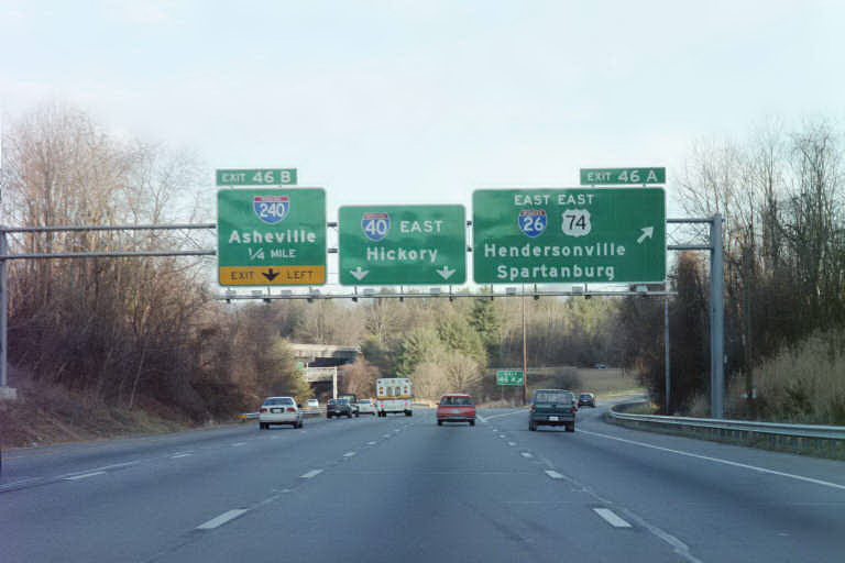
Exit 46A departed from I-40 east for I-26 to Spartanburg, South Carolina just prior to the left exit for I-240 east through Asheville. Photo by Jeffrey Napier (01/02).
![]() West at
West at ![]()
![]()

I-40 passes through the Biltmore Estate ahead of NC 191 (Brevard Road) and the original west end of Interstate 26 at Exit 46A. 08/23/03

I-40 crossed the French Broad River one mile ahead of the left exit for I-26/U.S. 74 east to Spartanburg, South Carolina. 08/23/03

A folded diamond interchange joined I-40 with N.C. 191 (Brevard Road) north to I-240 and West Asheville. There is no direct access to I-240 east from I-40 west. Photo by Jeffrey Napier (01/02).
Sources:
- “Fab road: I-26 through Smokies.” Charlotte Observer (NC), August 5, 2003.
- “Extending I-26 offers new opportunity.” Bristol Herald Courier (VA), August 3, 2003.
- “Highway opens to traffic.” Asheville Citizen Times (NC), August 5, 2003.
- I-26 Connector, Asheville, NC. NCDOT web site.
- Buchanan, Carter. “Re: I-26 and 485 Photos and More at All Things NC!” Online posting, Yahoo Groups – Southeast Roads and Transport, September 14, 2003.
- “DOT may delay I-26 Connector project,” Asheville Citizen-Times (NC), April 8, 2005.
- “Frist, Alexander, Jenkins applaud new designation of I-26.” Press Release, August 2, 2005.
- Interstate 50th Anniversary Fact of the Day: “On March 10, 1969, a dedication ceremony was held in Charleston, South Carolina, to mark the completion of the 221-mile-long segment of I-26 in the Palmetto State. This Interstate highway, which was the second one to be completed in South Carolina, stretches from the Atlantic Ocean to the Appalachian Mountains. That route includes a corridor between Charleston and Columbia that has been important in the state’s history since colonial times.”
http://www.interstate50th.org/ history/2006-03-10.shtml - NCRoads.com: I-26.
- “State accelerates I-26 Connector work, I-40 exit.” Citizen-Times (Asheville, NC), January 11, 2016.
- “Nation’s Longest Interstate Route.” Herald-Journal (Spartanburg, SC), November 11, 1959.
- “S.C. Too Fast With Highway, Hits Dead-End.” Herald-Journal (Spartanburg, SC), November 20, 1959.
- “Final Stretch Of I-26 In Spartanburg County.” Herald-Journal (Spartanburg, SC), October 15, 1964.
- “221-Mile I-26 Longest Of State’s Freeways.” Herald-Journal (Spartanburg, SC), February 28, 1979.
- “Interstate 26 Will Be Reality Thursday.” Herald-Journal (Spartanburg, SC), January 11, 1967.
- “Local backing helped make I-26 Connector route choice.” Citizen-Times (Asheville, NC), May 19, 2016.
- “Connector route taking traffic off Bowen Bridge picked.” Citizen-Times (Asheville, NC), May 19, 2016.
Page updated May 19, 2022.