Interstate 86 (Eastern)

Overview
Interstate 86 follows the corridor along New York Route 17 / Southern Tier Expressway, which was given high priority status in 1998. Designated in 1999, I-86 extends from just east of Erie, Pennsylvania across the Southern Tier of New York to the state line at Waverly. A second section runs along NY 17 from I-81 in Binghamton east ten miles to Windsor. Awaiting upgrades to Interstate standards, the remaining portion of the route is signed as NY 17. Specifically, key improvements are required in the Binghamton and Catskills areas.
Signs for Interstate 86 were installed between NY 17K and Interstate 84 in Orange County by at least 2019. The New York State Department of Transportation (NYSDOT) anticipated that a reconstruction project along this segment would meet Federal Highway Administration (FHWA) requirements for Interstate status. However FHWA field inspections identified a number of outstanding issues, mostly associated with right-of-way issues and access control at ramp terminals. FHWA requested that I-86 signs previously posted be covered until a longer continuous segment of NY 17 is ready for the Interstate designation.11
Ultimately, Interstate 86 will be signed across the entire Southern Tier, from Interstate 90 in Pennsylvania to I-87 (New York Thruway) at Harriman, New York. Locales served by the highway include Jamestown, Olean, Corning, Elmira, Binghamton, the lower Catskills region and Middletown. The entire route is known as the Daniel Patrick Moynihan Interstate Highway (per SAFETEA-LU Section 1929).
Upgrades to Route 17
NYSDOT held a Public Information Meeting on March 10, 2009 for the project upgrading NY 17 from Hale Eddy to Exit 87 / Hanock in Delaware County to limited access standards. The project was in the preliminary design phase by 2013. However no updates have been posted since.
A separate project further southeast reconstructs the cloverleaf (Exit 105) joining NY 17 with NY 42 into a dogbone interchange. A $30.87 million contract for construction was awarded on July 29, 2022. The estimated substantial completion for the work is December 1, 2024.
Estimated to cost $85 million, an interchange reconstruction project at Exit 122 in Sullivan County rebuilds the exchange to Interstate standards. Bid opening is anticipated for Spring 2024 with construction running from Summer 2024 to Spring 2025.
Completed upgrades to NY 17 in the Catskills Region include the reconstruction of the exchange at NY 32 (Averall Avenue) into a DDI and the addition of Exit 125 for Harriman Drive and South Street. Governor Kathy Hochul (D) announced the start of a draft Environmental Impact Statement (DEIS) on October 5, 2022 for the necessary upgrades to bring Route 17 up to Intestate standards through Orange and Sullivan Counties.12
High Priority Corridor
Interstate 86 in Pennsylvania and New York is part of High Priority Corridor 36: New York and Pennsylvania State Route 17.
 Parallel U.S. Routes
Interstate 86 does not follow any specific U.S. route with the exception of a small portion of U.S. 6 near the eventual east end.
History
Interstate 86 was originally established by the American Association of State Highway and Transportation Officials (AASHTO) on June 23, 1969 along a freeway corridor connecting Hartford, Connecticut with Sturbridge, Massachusetts. This was previously designated as I-84. Beginning at I-91 near Wethersfield, I-86 overlaid a portion of the freeway along Connecticut Route 3 (former I-491) to the freeway on Route 2 at East Hartford, with an unconstructed section extending northeast to meet I-84 at Manchester. I-86 followed I-84’s course from this point northeast along Wilbur Cross Highway into Massachusetts, ending at the Massachusetts Turnpike (I-90) north of Sturbridge. With I-86 overtaking the former route of I-84 from Manchester, I-84 was redirected eastward from I-86 along a freeway to Bolton, and ultimately toward Providence, Rhode Island.
The section of Interstate 86 that replaced I-491 between Wethersfield and I-84 at Manchester was decommissioned by AASHTO on July 13, 1976. Cancellation of the freeway from Route 2 northward through Glastonbury and East Hartford preceded the removal of I-86.
Signs for I-86 remained posted along Wilbur Cross Highway between I-84 at Manchester and Massachusetts until plans for the extension of I-84 to Providence were officially dropped. I-84 was reestablished along its pre-1969 course while I-86 was removed altogether. The freeway spur between Manchester and Bolton was assigned as I-384. AASHTO approved these changes on May 23, 1984.
The I-86 designation in upstate New York was approved by AASHTO on November 6, 1998 as a 430 mile long route, with the stipulation that it be signed as a future corridor until the various segments of the freeway were brought up to Interstate standards. Completion of the Southern Tier Expressway (NY 17 and PA 17) occurred at a ribbon cutting ceremony held by the governors of New York and Pennsylvania on October 2, 1997. Work finished included the $19.1 million construction of 9.3 miles of the two westbound lanes from Sherman, New York to the Pennsylvania state line and $14.9 million in construction on the seven mile stretch through Erie County. The two lane section of NY 17 in western New York was finished in the early 1980s.9 The westernmost 177 miles of the route in New York to Exit 48 in East Corning was officially upgraded to Interstate 86 on December 3, 1999 following dedication ceremonies held in Belfast and Corning.6
Within the village of Painted Post, Interstate 86 meets the north end of both I-99 and U.S. 15. Originally constructed in the late 1950s as a traffic circle, the exchange joining U.S. 15 and NY 17 was converted to a diamond interchange in 1987.
In September 1997, studies began on ways to improve the interchange and the nearby U.S. 15 ramps at Gang Mills. The New York State Department of Transportation (NYSDOT) followed with preparations on the Draft Environmental Impact Statement (DEIS) in October 1998. This document was complete by July 6, 2001. “Alternative 14” was selected as the preferred alternative by August 22, 2001. This option was modified after receiving input from the public in a December 6, 2001 Public Information Meeting.
Allowing the department to proceed with the final design for the project, the Federal Highway Administration (FHWA) gave approval to NYSDOT on June 3, 2002. Construction upgrading the exchange into a high speed directional T interchange proceeded. Costing $41 million, the first phase of the project commenced in November 2003. It included work to upgrade U.S. 15 to Interstate standards and build the diamond interchange at Hamilton Street.1 With $11 million in work running through Spring 2005, the second phase reconstructed a two mile stretch of I-86 through the interchange with U.S. 15 and rebuilt the railroad bridge over the Conhocton River.1 Focused on building the flyovers between the two freeways and ramps to Robert Dann Drive, the third and final phase started in Spring 2005. Work ran through August 13, 2008, when a ribbon cutting ceremony was held to celebrate the finish of the $141 million interchange.8
In February 2004, the FHWA approved the addition of eight more miles of I-86, extending the Interstate from Corning east to NY 14 / Exit 52 in Horseheads. Upgrades from Horseheads east to Exit 56 in Elmira resulted in the signing of the next section of I-86 on March 28, 2008.7
The Southern Tier Expressway east from Exit 56 in Elmira to Exit 60 at Waverly and South Waverly, Pennsylvania was incorporated as Interstate 86 on July 31, 2013. Further east during the Summer 2005, work upgrading NY 17 around Owego and also between Windsor and Hancock commenced.5 Funds for this along with other sections of future Interstate 86 were allocated in the 2005 SAFETEA-LU. The stretch from Waverly to Exit 67 awaits I-86 designation.
East from Interstate 81, a 9.9 mile long section between Kirkwood and Windsor was designated I-86 on May 1, 2006 (AASHTO approved this in May 2008). Beyond there, the 121 miles to Harriman vary between sections ready for designation and those still with at-grade intersections.7
Route Information
- East End – Windsor, NY
- West End –
 near Harborcreek, PA
 - Branch Routes – 0
- Total Mileage – 223.39
Mileage
Pennsylvania – 6.99
- Cities – None
- Junctions –
New York – 216.40
Cities – Jamestown, Olean, Hornell, Bath, Corning, Elmira, Binghamton
Junctions –

Source: December 31, 2021 Interstate Route Log and Finders List
I-86 Annual Average Daily Traffic (AADT)
Source: Statewide Traffic Volume Map 2017 (PennDOT)
NYS Traffic Data Viewer 2016 AADT

East of the original circle interchange between the Southern Tier Expressway and U.S. 15 at Painted Post, NY 17 defaulted onto Dennison Parkway, a congested route through Downtown Corning.
Major Projects
Between 2001 and 2009, NYSDOT upgraded various segments of NY 17 to Interstate standards. With the western segment of NY 17 between Erie and Corning already Interstate standard, attention was directed toward the central and eastern segments. This included required improvements at Elmira, the “Kamikaze Curve” in Binghamton, and near the Catskills Mountains. NYSDOT anticipated that this entire corridor would meet Interstate standards and be fully signed as Interstate 86 by 2009. The total cost to upgrade NY 17 to Interstate 86 was expected to run between $700 to $800 million. Ted Bennett, an I-86 Chairman, hoped to see the entire I-86 project complete by 2008. He believed that if completed by that date, the region would benefit in $3.2 billion growth.2
Work to upgrade Interstate 86 in Chemung County was completed by November 2012. Included was a $7.96 million interchange built at Kahler Road, which opened after two years of work on July 7, 2004.4 Construction to address the problem at Kamikaze Curve, the site where Interstate 81 and NY 17 overlap north of Downtown Binghamton, was to go to bid in May of 2006 (the project was eventually let on September 15, 2011). Roadwork on the $90 million project was to begin three months later and take about two years to complete.3
Split into separate phases and costing $148 million, The Prospect Mountain project included work to reconstruct NY 17 to Interstate standards from Exit 72 / Mygatt Street to NY 7 / Exit 4 A on the overlap with I-81. Construction reconfigured Exit 72, replaced bridges over the Chenango River and redesigned the exchange with NY 7 into a parclo. The majority of work ran through December 31, 2015.
Phase II of the Prospect Mountain Interchange Reconstruction started on May 15, 2016 with an original completion slated for December 31, 2020. Substantial completion was estimated for March 1, 2020. Work during this phase included reconstructing Exit 4 with new bridges and ramp improvements, and additional bridge replacements along NY 17.10
 Photo Guides
East End 
 – South Waverly, Pennsylvania
![]()
![]() East at
East at ![]()

I-86/NY 17 cross the Chemung River and dip southward into South Waverly, Pennsylvania, where they meet the north end of U.S. 220. 08/24/21
![]() North at
North at ![]()
![]()

U.S. 220 north ends at NY 17 (Southern Tier Expressway) and the temporary east end of Interstate 86 adjacent to the New York state line at South Waverly, Pennsylvania. 03/25/23
![]() West at
West at ![]()
![]()

NY 17 (Southern Tier Expressway) shifts south through the borough of South Waverly, Pennsylvania ahead of the parclo interchange (Exit 60) with U.S. 220. Interstate 86 commences west from the exchange. 03/25/23
Future East End – Harriman, New York
![]()
![]() East at
East at ![]()
![]()

U.S. 6 splits with Future I-86/NY 17 for Bear Mountain. The state route departs the freeway next ahead of the New York State Thruway connector (NY 984C). 03/28/23

Interstate 86 will conclude at I-87 just beyond the departure of NY 17 south to Suffern and New Jersey. NY 32 ties into this DDI (Exit 131) from Newbergh, 15 miles to the north. 03/28/23
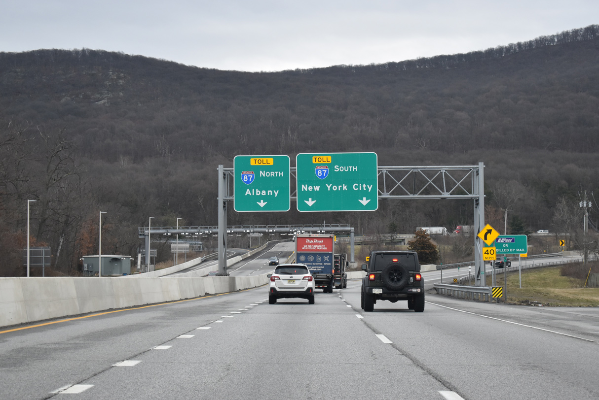
Two lanes join Interstate 87 (New York State Thruway) south to the Governor Mario M. Cuomo Bridge and New York City. A loop ramp joins the Thruway north to Kingston and the Capital District. 03/28/23
![]()
![]() North at
North at ![]()
![]()
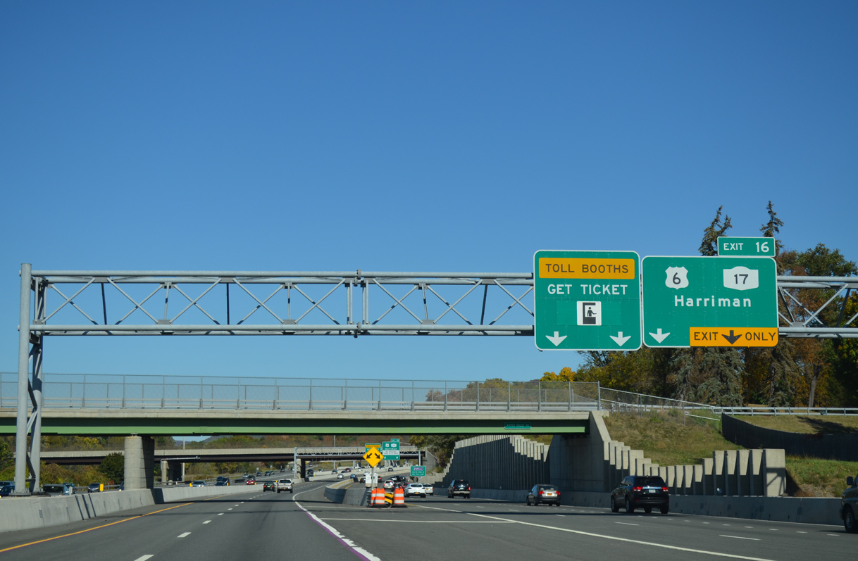
Exit 16 departs Interstate 87 (New York Thruway) northbound for U.S. 6, NY 17 and Future I-86 west ahead of the Woodbury Toll Plaza in the village of Harriman. 10/05/14
![]()
![]() South at
South at ![]()
![]()

The New York State Thruway makes a number of S-curves southward through town of Woodbury to the trumpet interchange (Exit 16) with Future Interstate 86 west to NY 17/32 at Harriman and U.S. 6 west to Goshen. 10/10/14
Former East End – Elmira, New York
![]()
![]() East at
East at ![]()

This shield assembly marked the temporary end of Interstate 86 shield at the Chemung/Steuben County line. The ensuing stretch of NY 17 east to NY 14 was added to I-86 in 2004. Photo by David Greenberger (04/00).

Interstate 86 previously ended beyond the interchange (Exit 52B) with New York Route 14 in the village of Horseheads. 07/04/05
![]() West at
West at ![]()
![]()

The first confirming marker for Interstate 86 west preceded the interchange joining NY 14 with NY 17 in Horseheads. 07/01/05

Interstate 86 bypasses Corning to the north, connecting preexisting segments of the Southern Tier Expressway (NY 17). 07/01/05
West End – Greenfield Township, Pennsylvania
![]() West at
West at ![]()

Advancing 2.5 miles west from PA 89, Interstate 86 approaches Exits 1B/A for I-90. PA 89 north provides a cut off to I-90 east near the borough of North East. Photo by Jim Teresco (06/06/01).

Interstate 86 defaults onto I-90 west (Exit 1A). I-90 passes south of Erie, meeting Interstate 79, 16 miles to the west. 10/07/01

An end shield accompanies milepost zero across from the gore point for Exit 1B to Interstate 90 east. 10/07/01
![]() East at
East at ![]()

Heading northeast from PA 531 outside Erie, Interstate 90 next meets I-86 east at Exit 37. 08/23/21

One quarter mile ahead of the trumpet interchange (Exit 37) with Interstate 86 in Greenfield Township. I-86 links with PA 89 ahead of the New York state line. Jamestown is 35 miles to the east. 08/23/21

Interstate 86 branches eastward across the Southern Tier of New York as I-90 continues to straddle the Lake Erie coastline northeastward. I-190 to Downtown Buffalo lies 69 miles to the northeast. 08/23/21
Throwback – at

Prior to the establishment of Interstate 86, the freeway east from I-90 was part of multi state route 17. The original PA 17 connects Blain and Liverpool to the north of Harrisburg. Photo taken by David Greenberger (07/30/98).

Posted for a short period of time, this shield assembly acknowledged the previous route number of I-86 in Pennsylvania. Photo taken by David Greenberger (04/00).
![]() West at
West at ![]()

Two miles ahead of Interstate 86 east to Jamestown, New York on I-90 westbound. 08/23/21

Advancing to within one mile of the trumpet interchange (Exit 37) with Interstate 86 east on I-90 west. 08/23/21

Exit 37 loops away from I-90 west to I-86 east ahead of Mina, Sherman and Chautauqua Lake in southwestern New York. 08/23/21
![]() East
East
The first confirming marker for Interstate 86 east stands ahead of the Dougan Road overpass. The seven mile stretch in Pennsylvania traverses agricultural areas and timberland. 08/23/21
Sources:
- “I-86, Rt. 15 interchange under way.” The Leader (Corning, NY), January 7, 2004.
- “Route 17 And Interstate 86 Plans.” WBNG-TV (Binghamton, NY), October 2, 2003.
- “Kamikaze Curve fixes won’t affect homes, park.” Press & Sun-Bulletin (Binghamton, NY), October 3, 2003.
- “Kahler interchange grand opening today” The Leader (Corning, NY), July 7, 2004.
- “Ten-mile I-86 segment near wrap-up: Group updated on progress, costs.” Binghamton Press & Sun-Bulletin (NY), April 8, 2005.
- “Long Stretch of Route 17 Becoming I-86 Today.” The Buffalo News, December 3, 1999.
- New York State Department of Transportation (NYSDOT). I-86 – Project Map. https://www.dot.ny.gov/regional-offices/region8/project-repository/Rte17WebSite/Demo Index.htm
- “Interchange complete” The Leader (Corning, NY), August 14, 2008.
- “Governors Rejoice As Highway’s Final Section Opens.” The Buffalo News (NY), October 3, 1997.
- New York State Department of Transportation (NYSDOT). Prospect Mountain Project. https://www.dot.ny.gov/prospectmountain.
- Re: NY 17/”I-86″, AARoads Forum posting by dzheng35, March 6, 2022.
- Bender, T. (2023, March 20). Route 17 expansion will improve mobility and enhance safety says coalition. Mid Hudson News. https://midhudsonnews.com/2023/03/20/route-17-expansion-will-improve-mobility-and-enhance-safety-says-coalition-2/
Page updated April 6, 2023.