Interstate 595 Maryland

Overview
I-595 in Maryland is the longest unsigned route within the Interstate Highway System. Aligned entirely along U.S. 50 (John Hanson Highway) and partially along U.S. 301, I-595 follows John Hanson Highway between I-95/495 (Capital Beltway) and MD 70 at Annapolis. U.S. 50/301 extend east from I-595 across the Severn River and Chesapeake Bay Bridge.
 History
Part of a spate of numbering changes sent by the Maryland State Highway Administration (MDSHA) to the Federal Highway Administration (FHWA) for approval on March 18, 1975. Included with the proposed new additions was Interstate 68, described as:
From a junction with FAI Route 495 east of Washington, D.C. via Bowie to the vicinity of Annapolis, State Capital of Maryland.
The transfer of funds from two canceled freeway projects in the Maryland suburbs provided financing for both the expansion and upgrading to freeway standards of U.S. 50 (John Hanson Highway) between the Capital Beltway (I-495) and Annapolis. Dropped from plans were I-70S and I-95 within the Capital Beltway. The transfer of around $270 million in funds was approved by the FHWA on July 24, 1975.
The U.S. Department of Transportation indicated that there were no objections to the proposed numbering changes with the exception of I-68. A letter sent to the American Association of State Highway and Transportation Officials (AASHTO) on November 11, 1975 concurred that I-68 should be considered a spur:
We concur with your position that proposed I-68 be considered a spur route to be numbered 595, 795, or 995. It would not seem desirable to number it I-595 because of the close proximity to the National Airport access road in nearby Virginia which is already numbered I-595. Thus I-795 would be an acceptable alternative.
MDSHA formally applied to AASHTO on November 15, 1975 to redesignate the freeway along U.S. 50 between the Capital Beltway and a point west of Annapolis as Interstate 68. AASHTO instead opted to conditionally approve the western portion of the route as an extension of Interstate 97, and the eastern section as Interstate 197. Neither of these routes were signed and construction had yet taken place on I-97 northward when Maryland again applied to AASHTO on October 3, 1981 for the I-68 designation along U.S. 50. This application included renumbering the I-197 leg as Interstate 168 however. Finally on June 7, 1989, AASHTO approved renumbering U.S. 48 and the National Freeway in western Maryland as Interstate 68, and the former I-68 proposal along U.S. 50/301 as Interstate 595.
John Hanson Highway, U.S. 50 from D.C. east to Annapolis was upgraded starting in the mid 1980s. Work focused on modernizing the aging freeway by replacing overpasses, redesigning interchanges and adding lanes. Further widening commenced in May 1992 with expansion to six and eight lanes from Interstate 97 to just west of the Patuxent River. The $93 million project included the replacing the compact cloverleaf interchange with U.S. 301/MD 3.1
Upon completion of the freeway upgrade in 1995, U.S. 50 was to be cosigned as Interstate 595. However since travelers were already familiar with the U.S. 50 and U.S. 301 designations, officials reconsidered signing I-595 and instead opted to designate it a hidden route. However, some signs for U.S. 50 posted in the early 1990s were designed with space reserved for Interstate 595 shields.
Route Information
East End – Annapolis, MD
- West End – New Carrollton, MD
Mileage – 19.97
Cities – New Carrollton, Bowie, Annapolis
- Junctions –


Source: December 31, 2021 Interstate Route Log and Finders List
I-595 Annual Average Daily Traffic (AADT)

The I-595 portion of John Hanson Highway was open from MD 704 (Exit 8) eastward to MD 2 (Ritchie Highway) by 1957.2 The 1961 Maryland map shows an alignment shielded as Temp U.S. 50 using E Capitol Street, MD 704 and John Hanson Highway east to MD 3 and the merge with U.S. 301.
 Photo Guides
East End 
 – Annapolis, Maryland
![]()
![]() East
East ![]()
![]() North
North

U.S. 50 east / U.S. 301 north advance east from the overlap with MD 2 / Exit 23 three quarters of a mile to MD 70 (Rowe Boulevard). Interstate 595 ends at the upcoming exchange (Exit 24). 12/16/22
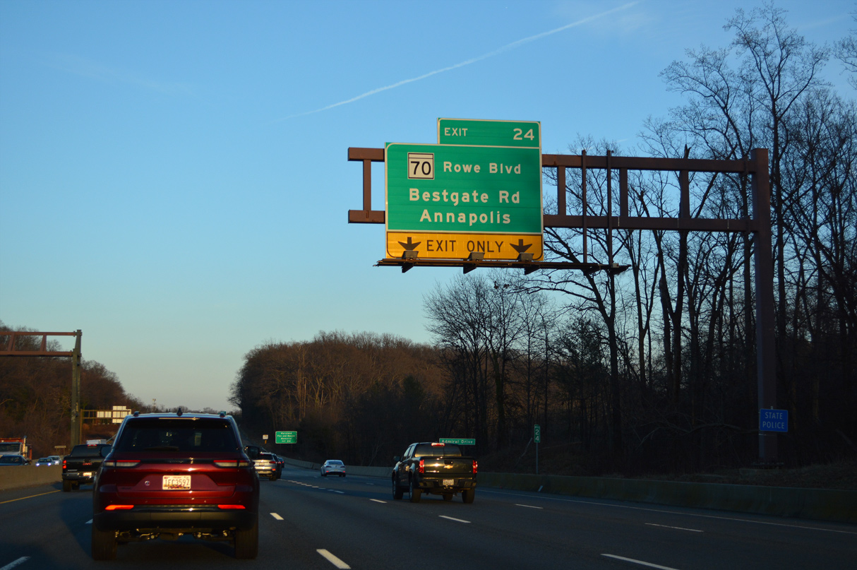
Spanning Weems Creek with five lanes, U.S. 50/301 continue a half mile to the parclo interchange (Exit 24) with MD 70. MD 70 constitutes a divided arterial southeast to Downtown Annapolis and the Maryland State House. 12/21/22

A lane drop occurs along the freeway eastbound for Exit 24 to MD 70 (Rowe Boulevard). I-595 concludes 7.2 miles from the Chesapeake Bay Bridge. MD 2 crosses the Severn River with U.S. 50-301 to Exit 27, where it turns north to Glen Burnie and Baltimore. 12/16/22
![]() West
West ![]()
![]() South
South

MD 2 south combines with U.S. 50-301 ahead of the Severn River, one mile out from MD 70 (Rowe Boulevard) and the unsigned beginning of Interstate 595 west. 12/27/22

U.S. 50-301 meets MD 70 (Rowe Boulevard) just outside the Annapolis city limits at the community of Weems Creek. Rowe Boulevard is apart of MD 70, a 2.32 mile long route from College Avenue (MD 450) by the Maryland State House to Bestgate Road just north of I-595/U.S. 50-301. 12/21/22

Bestgate Road parallels I-595 as it extends west from MD 70 and Rowe Boulevard to Westfield Annapolis Mall and MD 178 (Generals Highway). 12/21/22

Exit 24 A loops away from U.S. 50-301 west for MD 70 (Rowe Boulevard) south across Weems Creek. MD 2 splits with the freeway at the ensuing exit with Solomons Island Road. Unsigned I-595 commences west 2.1 miles from the partition with the exit to Interstate 97 north. 12/21/22
West End  Capital Beltway – New Carrollton, Maryland
![]()
![]() West at
West at ![]()
![]()

I-595/U.S. 50 (John Hanson Highway) converge with I-95/495 (Capital Beltway) west of Mitchellville in two miles. 12/27/22

MD 704 (M.L. King, Jr. Highway) angles southwest across I-595/U.S. 50 to Glenarden, one mile east of the turbine interchange with the Capital Beltway. 12/27/22

I-95/495 overlap 26.11 miles north from the District of Columbia line on the Woodrow Wilson Bridge to College Park and Hillandale. 12/27/22

I-95 branches northeast from the Capital Beltway to Laurel and Baltimore while I-495 continues west to Silver Spring and Bethesda. 12/27/22

I-95 branches northeast from the Capital Beltway to Laurel and Baltimore while I-495 continues west to Silver Spring and Bethesda. 12/27/22
![]() East at
East at ![]()
![]()
![]()

U.S. 50 (John Hanson Highway) runs alongside the AMTRAK Northeast Corridor and MARC to a diamond interchange (Exit 5) with MD 410. MD 410 (East West Highway) stems north to Woodlawn as U.S. 50 continues east one mile to the Capital Beltway and Interstate 595. 06/02/03

U.S. 50 eastbound expands with two auxiliary lanes from the New Carrollton Station entrance ramp to the turbine interchange (Exits 7A/B) with I-95/495 (Capital Beltway). Exit numbers along Interstate 595 continue the U.S. 50 numbering sequence from the D.C. line. 06/02/03

Guide signs installed during reconstruction of the former cloverleaf interchange between U.S. 50 (Hanson Highway) and the Capital Beltway in the early 1990s included space allocated for I-595. Most of these assemblies were eventually replaced. 06/02/03

Exit 7 parts ways with U.S. 50 (Hanson Highway) east, carrying traffic to both I-95/495 south to Alexandria, Virginia and the Beltway north to Greenbelt and Beltsville. 06/02/03
![]()
![]() North at
North at ![]()
![]()

I-95/495 (Capital Beltway) heads north one mile from the city of Glenarden to I-595 east and U.S. 50 at Exit 19. 12/17/20

Guide signs for Exit 19 on I-95/495 north include space for I-595 shields. 12/16/16

Exit 19A departs I-95/495 north at Springfield for unsigned I-595 and U.S. 50 east to Bowie and Annapolis. 12/17/20
Sources:
- “Interstate 595: Unfamiliar name, well-known pain.” The Sun (Baltimore, MD), May 31, 1993.
- MDRoads: US 50.
Page updated April 7, 2023.