Interstate 99


Overview
Interstate 99 is a rural freeway traveling northward through central Pennsylvania from Bedford near the PA Turnpike (I- 70/76) to I-80 near Bellefonte. Also known as the Appalachian Thruway and the Bud Shuster Byway, it is the first Interstate highway to have its designation written into law (National Highway Designation Act of 1995). The designations for several other Interstates, including I-66 in Kentucky, I-86 in New York, and I-69 in Texas, were subsequently written into law.
Ultimately, I-99 will continue north from I-80 via U.S. 220 to Lock Haven and Williamsport, and along U.S. 15 north to the New York state line by Lawrenceville. The short section of U.S. 15 leading north to I-86 at Painted Post, NY was designated as Interstate 99 on June 27, 2014.1
Speed limits along Interstate 99 were raised to 70 miles per hour (mph) from mile marker 34 in Blair County to Exit 68 in Centre County, and from mile marker zero at the PA Turnpike in Bedford County to Exit 28 in Blair County. Additionally a 49 mile stretch of U.S. 15, from PA 14 in Lycoming County to the New York state line, was increased to 70 mph. PennDOT announced increases on these stretches in May 2016.2
Located east of I-79 and west of I-81, I-99 falls outside the standard numbering convention outlined for Interstate highways. Under the orderly system, odd numbered Interstates increase in number from I-5 on the West Coast eastward to the Atlantic seaboard. While central Pennsylvania is pretty far east, it is still well away from the Atlantic Ocean. Several north-south routes, including I-81, I-83, I-87, I-89, I-91, I-93, I-95 and I-97 all lie east of Interstate 99. Congressman Bud Shuster both determined the number for the Appalachian Thruway and was responsible for writing Interstate 99’s designation into the 1995 National Highway Designation Act.
Interstate 80/99 Interchange
A $35 million Infrastructure for Rebuilding America Grant (INFRA) was awarded to the Pennsylvania Department of Transportation toward funding construction of a high speed interchange linking I-99 with I-80 near Bellefonte on June 5, 2018. Estimated to cost around $200 million,14 the new ramp system replaces the parclo A2 interchange at U.S. 220 and PA 26 joining the north end of I-99 with Interstate 80.
The overall project consists of three sections. Underway in June 2020, initial construction built a new local access interchange connecting I-80 with PA 26 to the east of the exchange with I-99. This exchange was completed in mid December 2022.
The Jacksonville Road Betterment (26/147) project realigns and expands PA 26 along Jacksonville Road. With an estimated cost of $4 to 6 million, it is scheduled to go to bid on October 20, 2022 in Fall 2023.
The remainder of work building the three-wye interchange for I-80/99 is scheduled to bid on March 3, 2022 February 16, 2023 in Fall 2023. Construction of the high speed exchange is estimated to cost $175 $190 million. Work was originally anticipated to run through December 2025.14
High Priority Corridor
Interstate 99 in central Pennsylvania is part of High Priority Corridor 9: Appalachian Thruway Corridor.
 Parallel U.S. Routes
Interstate 99 between Bedford and Bellefonte overlaps with U.S. 220 for its entirety, and it will continue along U.S. 220 until reaching U.S. 15 at Williamsport. Interstate 99 is currently cosigned with U.S. 15 in New York, and will overlap or replace U.S. 15 southward to Williamsport when it is finally signed.
Future Plans
The south end of Interstate 99 in Bedford may change in the future, as the highway is part of the Appalachian Thruway/High Priority Corridor 9. Improvements are envisioned for U.S. 220 south to Cumberland, though expansion to Interstate standards are not presently planned.
It is also possible that Interstate 99 could continue north all the way to Rochester via I-390. Although some discussions have considered the possibility of I-83 continuing north to Rochester, it does not appear that will occur due to the large gap of Interstate-standard freeway between Harrisburg and U.S. 15.
History
The initial section of the U.S. 220 freeway opened south from Bedford Township to U.S. 30 in 1969. The remainder of the route north through Bedford and Blair Counties was built in the 1970s and 1980s.3 $138 million in upgrades to Interstate standards took place along the U.S. 220 freeway north from Bedford to Bald Eagle to 1989.4 Discussions followed in the early 1990s to extend the freeway north 30 miles through Centre County to I-80 near Bellefonte.3 Spearheaded by U.S. Rep. Bud Shuster, R-Everett, the first signs for I-99 were unveiled on December 1, 1995 near the interchange with 17th Street in Altoona. The designation of 35 miles of U.S. 220 between Bedford and Altoona was included in the National Highway System Designation Act signed by President Clinton on November 28, 1995. The bill added 161,000 miles of roads into the National Highway System, which gained priority for federal funding. The law provided $118 million of the estimated $370 million needed at the time to complete the 30 mile long I-99 corridor north from Bald Eagle through State College.4
Three sections were proposed in 1995 to complete Interstate 99 north from Bald Eagle to the Bellefonte Bypass (PA 26). The 17.5 mile long segment from Bald Eagle to U.S. 322, including a bypass of Port Matilda, was estimated to cost $365 million. This section stretches across Skytop Mountain to join the Mount Nitanny Expressway (U.S. 322 around State College).4
The second section involved upgrading U.S. 322 between Scotia Road and Park Avenue Extension, and a relocation of PA 26. Also included was a new eight mile alignment linking U.S. 322 at Park Avenue Extension with the Bellefonte Bypass. Expansion of the four mile long Bellefonte Bypass in Spring Township represented the last section at a cost of $180 million.4
An Environmental Impact Statement for I-99 over Bald Eagle Ridge was completed by the Pennsylvania Department of Transportation (PennDOT) in 1996. The approval of TEA-21 by Congress in 1998 included a two sentence rider by U.S. Rep. Bud Shuster that eliminated federal oversight of Interstate 99.3 Subsequent approval for I-99 between Bedford and Bald Eagle was approved by the American Association of State Highway and Transportation Officials (AASHTO) Route Numbering Subcommittee on November 6, 1998.
Land clearing for I-99 commenced in 1999 near Bellefonte and a $39 million contract to build 1.3 miles of new roadway over Bald Eagle Ridge at Skytop was awarded in 2001.3 Meanwhile the eight mile link between State College and Interstate 80 opened to motorists on November 25, 2002. Costing $200 million to build, the segment includes six interchanges.5
Route Information
Mileage
Pennsylvania – 85.74
Cities – Bedford, Altoona, Bald Eagle, State College, Bellefonte
Junctions –


New York – 12.60
Cities – Corning
- Junctions –
Source: December 31, 2021 Interstate Route Log and Finders List
I-99 Annual Average Daily Traffic (AADT)
Source: Pennsylvania Traffic Volume Map 2017 (PennDOT)
NYS Traffic Data Viewer 2016 AADT

Interstate 99 debuted on the 1995 Official Pennsylvania Highway map from the trumpet interchange with the U.S. 220 Business access road in Bedford to PA 350 at Bald Eagle.

Three Future Interstate 99 corridor signs were posted along U.S. 15 northbound between Williamsport and the New York state line, including this assembly at the north end of the Mansfield Bypass. U.S. 15 Business converges with U.S. 15 northbound ahead. 05/07/05
Construction of the route west of State College, known as the “Skytop” section, was hampered with delays due to environmental concerns associated with acid rock–sandstone laced with pyrite. Without measures in place to prevent contamination of streams and ground water, crews in 2003 unearthed a million cubic years of the pyrite-laced sandstone, which when exposed to air and water creates sulfuric acid. $82.7 million in work ensued in 2004 to contain the runoff and clean up the site. This delayed work from an anticipated 2006 completion date.3
Following years of delays, the 14 mile link between Bald Eagle and Patton Township opened on December 17, 2007, with the exception of the 1.4 mile long section at the acid-rock drainage cleanup site on Skytop Mountain.6
The section between Skytop and State College was finally completed on November 17, 2008, when eight miles of the freeway southbound opened. Total costs for this section of I-99 was $702 million. This left the work on the planned high speed interchange joining I-80 and I-99. Projected to cost $146 million in 2008, redesign of the exchange was undertaken to avoid excavating too much pyrite.3
The remainder of Interstate 99 in Pennsylvania is a future route with signs proclaiming its extension along U.S. 220 to Lock Haven and Williamsport, then northward along U.S. 15 to the state line at Lawrenceville.
Several decades of construction upgraded U.S. 15 between Williamsport and Painted Post to limited access standards. A new freeway for U.S. 15, from Tioga, Pennsylvania north to Lindley, New York, opened after a ribbon cutting ceremony held on October 1, 2008. The seven mile segment cost $118.7 million.7 See photos of the roadway on John Walter’s site.
Interstate 99 in New York
Within Steuben County and the village of Painted Posted, New York, construction to upgrade the exchange between the Southern Tier Expressway and U.S. 15 (Interstate 99) started in November 2003. The first phase of work involved a $41 million project to bring U.S. 15 up to Interstate standards and to add a diamond interchange with NY 417 (Addison Road / Hamilton Street). The second phase, costing $11 million, rebuilt a two mile stretch of I-86 by the north end of U.S. 15.8
The final phase of the Painted Post Interchange project added flyovers for the eventual freeway leading U.S. 15 south to Presho and reconstructed Hamilton Street and Robert Dann Drive. The $70 million project commenced in Spring 2005 and was scheduled for a Fall 2007 completion.9 Delays pushed work to a ribbon cutting ceremony held on the morning of August 13, 2008. Total costs for the three phase project topped out at $141 million.10
Road construction on the final five mile portion, north from Watson Creek Road at Lindley to Presho, began in August 2012. Taking place as $46 million in ground work wrapped up, the $31 million project included building six bridges.8 Completion took place on October 8, 2013. Overall costs to build Interstate 99 in New York were $238 million.11
 Photo Guides
North End – NY Section –  – Painted Post, New York
![]()
![]() North at
North at ![]()
![]()
Continuing past NY 417 (Hamilton Street) in Gang Mills, I-99/U.S. 15 advance one mile north to the separation of flyovers for I-86/NY 17. 03/25/23

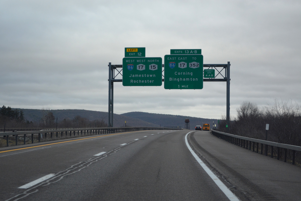
Exits along I-99 were renumbered to a mile based system. Exits 4 A/B changed to Left Exit 12 for I-86 west and Exit 13 A for I-86 east. 03/25/23

A high speed ramp links Robert Dann Drive with I-99 north ahead of Exits 13 A/B for I-86/NY 17 east and NY 352 along Buffalo Street and Denison Parkway. 03/25/23


A pair of end shields for Interstate 99 stand above the entrance ramp from Robert Dann Drive in Painted Post. 03/25/23, 08/24/21

The flyover for I-86/NY 17 east spans the Cochocton River before splitting with Exit 13 B for NY 352 into the city of Corning. 08/24/21
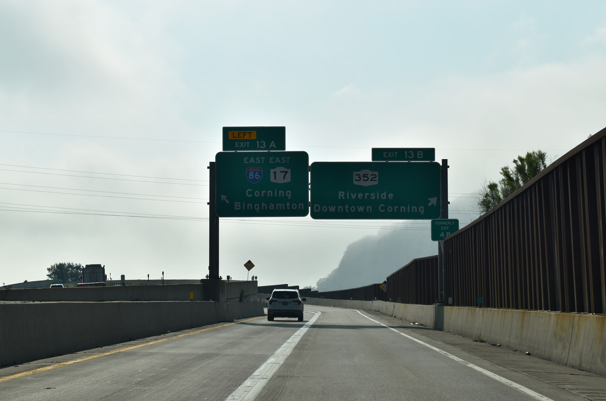
Left Exit 13 A joins I-86/NY 17 along a bypass of Corning toward Binghamton. 08/24/21
![]()
![]() East at
East at ![]()
![]()

An auxiliary lane accompanies I-86/NY 17 east from NY 415 (Exit 43) to the interchange complex (Exits 44A/B) with I-99/U.S. 15 south and NY 417 (Hamilton Street) west. 01/18/17

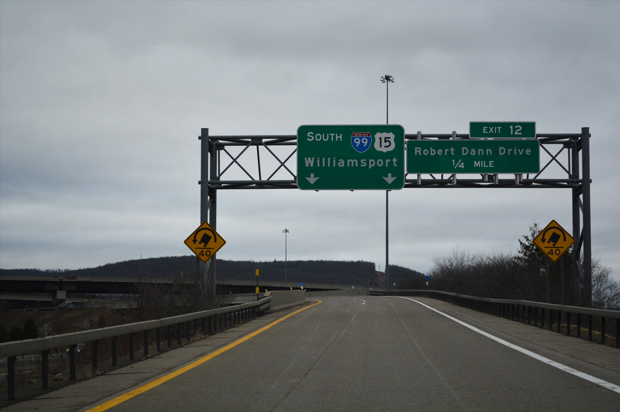
Exit 44 expands to two lanes as it separates from the I-86 eastbound mainline. A two lane flyover shuttles motorists onto I-99 south to Lawrenceville, Pennsylvania while a single lane ramp lowers to Hamilton Street at the village of Painted Post. 01/18/17

I-99/U.S. 15 overlap south by Presho and Lindley to the Pennsylvania state line. U.S. 15 extends south from there as a freeway to Mansfield and I-180 at Williamsport. NY 417 is the pre-freeway alignment of NY 17 between Olean and Gang Mills in southern Allegany and Steuben Counties. 01/18/17
![]()
![]() West at
West at ![]()
![]()

A flyover links NY 352 on Denison Parkway with NY 417 (Hamilton Street) beside I-86/NY 17 west into the directional T interchange (Exit 44 A) with I-99/U.S. 15 south. 03/25/23

Exit 44 A leaves I-86/NY 17 west for I-99/U.S. 15 south toward Williamsport, Pennsylvania and Robert Dann Drive in south Painted Post. 03/25/23
Exit 12 departs from the ramp linking I-86/NY 17 west with I-99/U.S. 15 south to Robert Dann Drive just south of the Cohocton River. This ramp is not accessible from I-86/NY 17 eastbound. 03/25/23
South End – NY Section – – Pennsylvania state at Lawrenceville
![]()
![]() South
South

Interstate 99 concludes southbound along U.S. 15 at the state line by Lawrenceville, Pennsylvania. 03/25/23
![]()
![]() North
North

The freeway along U.S. 15 becomes part of Interstate 99 north into the town of Lindley, New York. 03/25/23
North End Throwback
![]() North at
North at ![]()
![]()

Traveling north along the original U.S. 15 freeway to I-86/NY 17 at Painted Post. A diamond interchange joined the two freeways at the time. Photo by Douglas Kerr (10/05/02).

A trumpet interchange joined U.S. 15 with adjacent NY 417 just south of the ramps for I-86/NY 17 (Southern Tier Expressway). This exit was reconfigured into a wye interchange during the second phase of the Painted Post Interchange project. 05/07/05

Traffic departed from the ending U.S. 15 north for Interstate 86/NY 17 east to Corning and Elmira. Ahead was a left turn for I-86/NY 17 west and NY 15 north at a signalized intersection. 05/07/05

Hamilton Street (NY 415) extended north from the freeway end into the village of Painted Post. The diamond interchange with the Southern Tier Expressway here replaced a circle-interchange built in the late 1950s. That design was replaced in 1987.13 05/07/05
![]()
![]() West at
West at ![]()

Button copy guide sign posted ahead of Exit 44 for U.S. 15 south and NY 417 west during the Painted Post Interchange project. U.S. 15 was previously upgraded to a freeway between NY 17 and Presho. 07/01/05

Westbound Interstate 86/NY 17 combined with NY 15 north from Exit 44 as U.S. 15 south began. NY 15 was designated along the former U.S. 15 route between Painted Post and Rochester in 1974. 07/01/05

A signalized turn took motorists from NY 17 (Southern Tier Expressway) west onto U.S. 15 south at Painted Post prior to the multi year project to build the directional T interchange for the eventual I-99. Photo by Bryan Farr (04/15/02).
North End – PA Section –  – near Bellefonte, Pennsylvania
![]()
![]()
![]() North at
North at ![]()
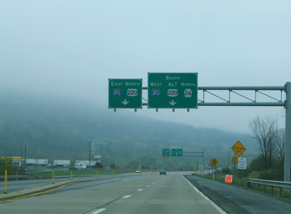
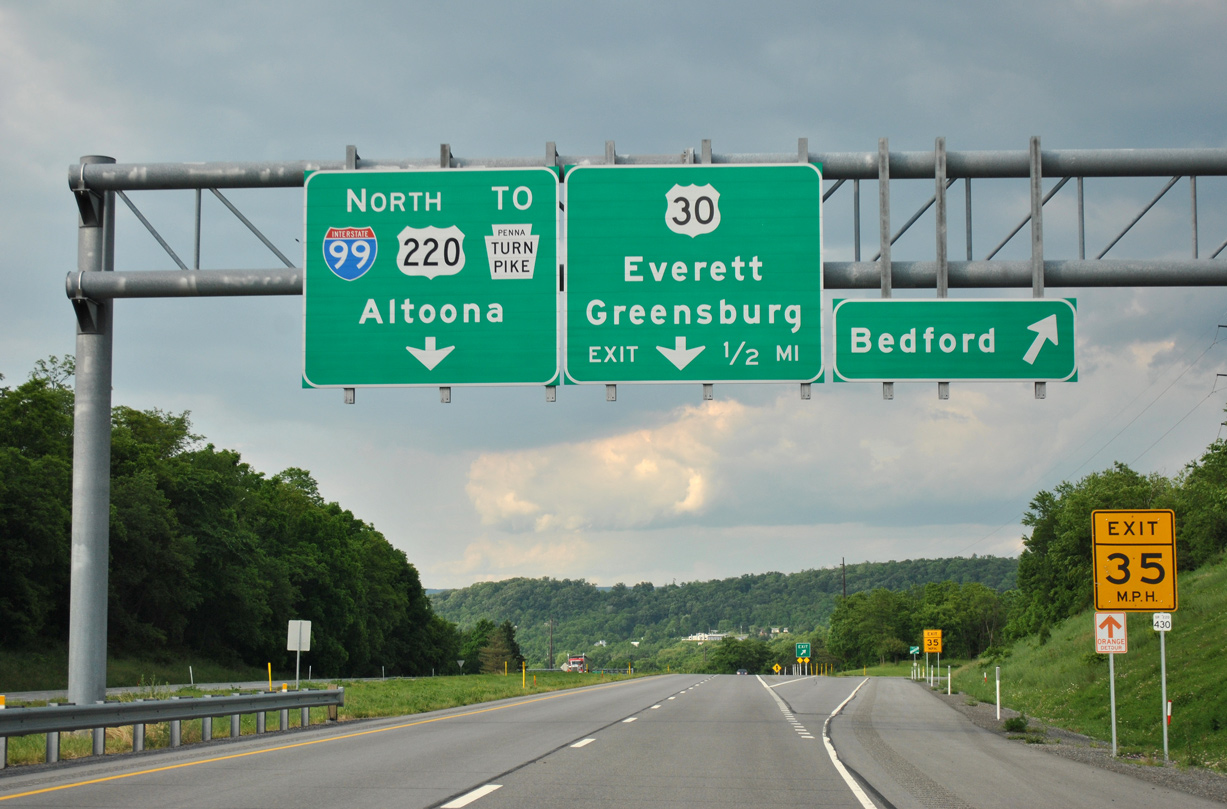
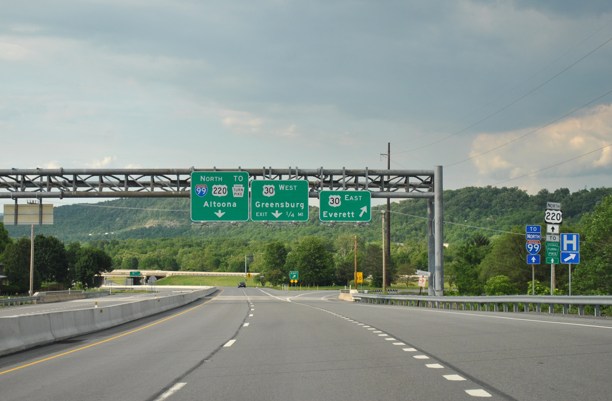
I-99/U.S. 220 travel from the Mount Nittany Expressway (U.S. 322) at State College to Interstate 80 northeast of Bellefonte. The freeway transitions into an at-grade expressway at Musser Lane, 0.4 miles ahead of the eastbound on-ramp for I-80. These overheads were replaced by 2015 and the concrete roadway was covered with asphalt. 04/30/05

Jacksonville Road (former PA 26) ties into I-99/U.S. 220 at an intersection preceding the parclo A2 interchange with I-80. This set of signs, still referencing the former U.S. 220 Alternate route along I-80 west to Milesburg, was later removed. 04/30/05

U.S. 220 north accompanies I-80 east for 17 miles. U.S. 220 Alt south to Milesburg and Unionville was decommissioned with the completion of Interstate 99 at Port Matilda. 04/30/05

PA 26 (Jacksonville Road) north reduces to two lanes ahead of the I-80 overpasses and westbound entrance ramp to Dubois. 04/30/05

Interstate 80 proceeds west from I-99 to DuBois, Clarion, Sharon and Youngstown, Ohio. PA 26 continues northeast to Jacksonville and Howard. 04/30/05
Historic Northern Terminus – – Bald Eagle, Pennsylvania

An end shield preceded a wye interchange taking U.S. 220 back onto its old alignment from I-99 at Bald Eagle. Photo by Oscar Voss (07/99).

PA 350 (7 Stars Road) westbound combined with U.S. 220 at a T-intersection just north of the temporary freeway end of I-99. Photo by Tim Reichard (04/07/02).

PA 350 combined with U.S. 220 north to U.S. 220 Business (Eagle Valley Road) at nearby Bad Eagle while U.S. 220 south combined with I-99 to Tyrone and Altoona. The temporary freeway end is now an access road linking Bald Eagle with I-99 via a diamond interchange (Exit 52). Photo by Tim Reichard (04/07/02).

U.S. 220 turned south from Eagle Valley Road to overlap with PA 350 to the I-99 access road beyond 7 Stars Road. PA 350 still turns east here toward Warriors Mark and Seven Stars. 04/30/05

U.S. 220 extended south from 7 Stars Road to a temporary wye interchange at the southbound beginning of Interstate 99. The interchange was reconfigured into a diamond to provide access from PA 350 and Bald Eagle for I-99 north to State College. 04/30/05
South End – Bedford Township, Pennsylvania
![]()
![]() South at
South at ![]()

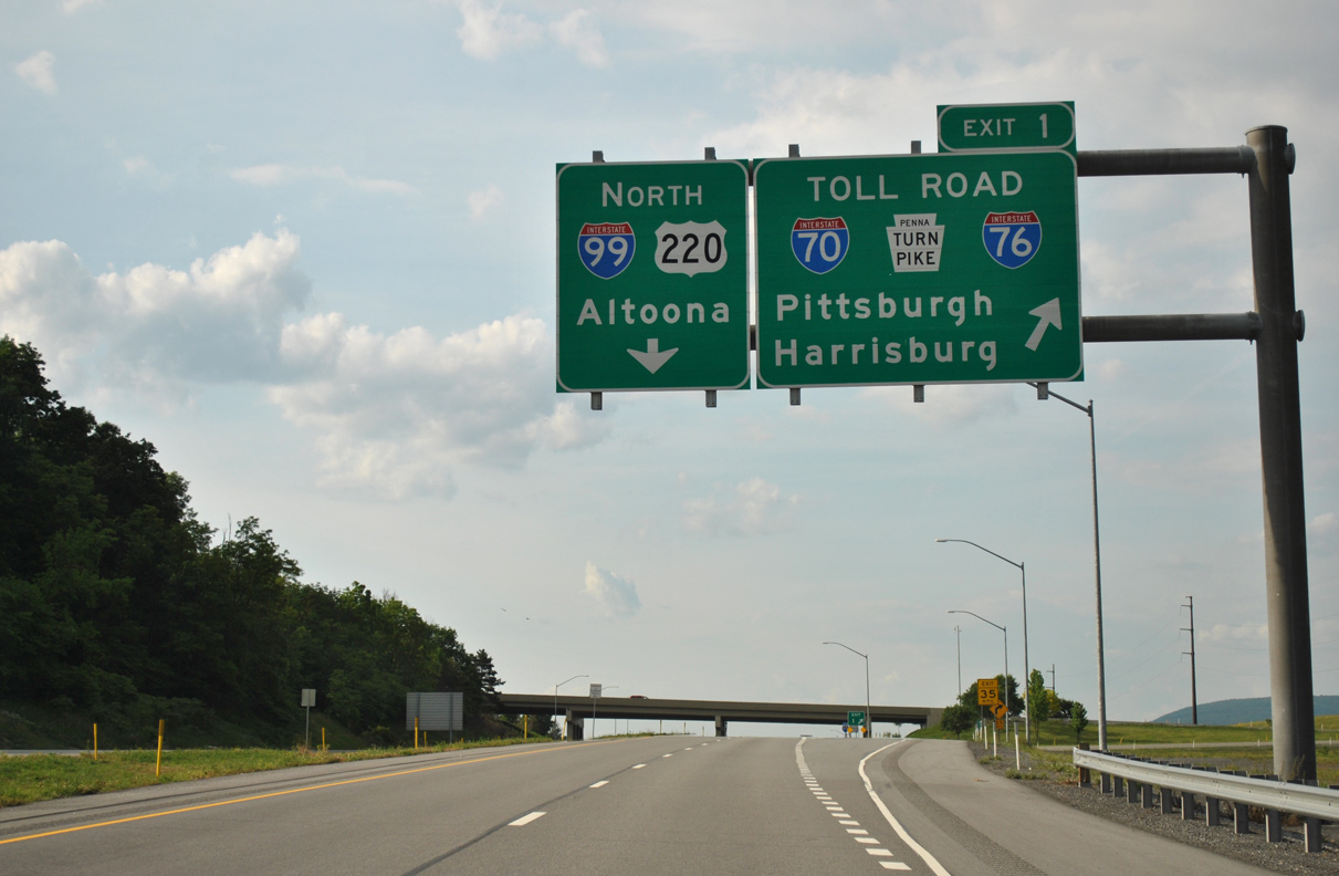
Interstate 99/U.S. 220 proceeds south from a diamond interchange (Exit 3) with PA 56 at Cessna toward Exit 1 for the Pennsylvania Turnpike. 04/30/05

An end shield for I-99 stands ahead of the trumpet interchange (Exit 1) with the access road linking U.S. 220 with U.S. 220 Business. The U.S. 220 freeway extends another three miles to Bedford. The US highway reaches the Maryland State line in 27 miles. Photo by Oscar Voss (07/99).

Similar to Breezewood, the connection between Interstate 99 and the PA Turnpike leads motorists by several gas stations and fast food restaurants through Bedford Township. 04/30/05

U.S. 220 Business extends 3.1 miles north to end at Interstate 99 along side PA 56 at Cessna and south 0.3 miles to the Pennsylvania Turnpike ramps at Exit 146. 04/30/05

I-70 and I-76 split 17 miles to the east, while the Steel City of Pittsburgh is 100 miles to the west via the Pennsylvania Turnpike and I-376. Downtown Bedford lies 2.6 miles ahead on U.S. 220 Business south. 04/30/05
![]() North at
North at ![]()
U.S. 220 expands to a four lane freeway along the west side of Bedford. Back to back interchanges join the US route with Pitt Street and U.S. 30. Interstate 99 begins in 2.5 miles. 06/08/12
U.S. 220 expands to a four lane freeway along the west side of Bedford. Back to back interchanges join the US route with Pitt Street and U.S. 30. Interstate 99 begins in 2.5 miles. 06/08/12
Exit 1 connects I-99/U.S. 220 with an access road linking with U.S. 220 Business and the Bedford Interchange along the Pennsylvania Turnpike (I-70/76). I-99/U.S. 220 travel 32 miles north to Altoona. 06/08/12

The first confirming marker for Interstate 99 north stands within the trumpet interchange with the access road to U.S. 220 Business. 06/08/12
![]()
![]()
![]() East at
East at ![]()
![]()

I-70/76 parallel U.S. 30 closely on the two mile approach to Exit 146 with U.S. 220 Business in Bedford Township. Photo by Chris and Amber Lokken (06/24/08).

Passing north of Wolfsburg, the Pennsylvania Turnpike continues to within one mile of the trumpet interchange (Exit 146) for Bedford. I-99 and U.S. 220 combine north to Altoona, Bald Eagle and State College. Photo by Chris and Amber Lokken (06/24/08).

Exit 146 departs following the Bugle Road and U.S. 220 freeway overpasses for U.S. 220 Business. U.S. 220 Business leads motorists north 0.3 miles to an access road linking with I-99 north to Altoona and U.S. 220 south to Cumberland, Maryland. A similar surface route connection links the PA Turnpike with I-81 at Carlisle. Photo by Chris and Amber Lokken (06/24/08).
![]()
![]()
![]() West at
West at ![]()
![]()

The Pennsylvania Turnpike angles northwest from The Narrows across Evitts Mountain to meet U.S. 220 Business at Exit 146. I-99/U.S. 220 travel northeast to State College. 10/15/04

U.S. 220 Business travels north from the borough of Bedford to meet the Pennsylvania Turnpike in one mile. The arterial route connects I-70/76 with I-99 via an adjacent access road. The connection requires navigating through two signalized intersections. 10/15/04

Entering the trumpet interchange (Exit 146) with U.S. 220 Business on I-70/76 westbound. U.S. 220 Business parallels I-99/U.S. 220 north to Cessna. U.S. 220 continues south from the end of I-99 another seven miles to Cumberland Valley. 10/15/04
South End Throwback
![]() North at
North at ![]()
![]()

The signalized end of the Exit 146 access road for U.S. 220 Business. According to William F. Yurasko, a button copy sign including an I-99 shield was previously posted at this location. 10/08/01

Approaching the access road connecting U.S. 220 Business with Interstate 99 and U.S. 220. Overhead signs were added here by 2008. 10/08/01

Replaced by 2005, traffic partitioned into ramps for I-99/U.S. 220 north to State College and U.S. 220 south to Cumberland beyond this set of button copy overheads. 10/08/01
Sources:
- “Steuben County stretch of Route 15 designated as Interstate 99.” The Leader (Corning, NY), June 27, 2014.
- “Infrastructure – Speed limit extension announced.” Wayne Independent, The (Honesdale, PA) May 7, 2016.
- “Long-awaited Interstate 99 Finished – Road was Long, Rocky and with Stops for Direction.” Centre Daily Times (State College, PA), November 23, 2008.
- “Map Makers Must Draw in New I-99.” Centre Daily Times (State College, PA), December 1, 1995.
- “Drivers Hit Onramps of New I-99.” Centre Daily Times (State College, PA), November 26, 2002.
- “I-99 Link Opens – Connection to Skytop Complete after Years of Setbacks.” Centre Daily Times (State College, PA), December 18, 2007.
- “Work complete on U.S. 15 section.” Leader, The (Corning, NY), October 2, 2008.
- “Final phase of U.S. 15 upgrade underway – I-99 Conversion.” Leader, The (Corning, NY), August 21, 2012.
- “I-86, Rt. 15 interchange under way.” Leader, The (Corning, NY), January 7, 2004.
- “Interchange project prepares for final phase.” Leader, The (Corning, NY), October 22, 2004.
- “Interchange complete.” Leader, The (Corning, NY), August 14, 2008.
- “Route 15 open for business 10-year future I-99 project hits finish line in Lindley – 10-year future I-99 project hits finish line in Lindley.” Leader, The (Corning, NY), October 9, 2013.
- Interstate 86 / Route 15 Interchange Website – Project History,
http://www.dot.state.ny.us/reg/r6/i86_project/i86projhistory.htmlNYSDOT. - “PennDOT Details New Local Access Tied to I-80/I-99 Interchange Project.” Centre County Gazette (State College, PA), March 1, 2019.
Page updated April 5, 2023.