Interstate 820 Texas

Overview
Part of the Fort Worth beltway, Interstate 820 (Jim Wright Freeway) wraps around the west, north, and east sides of the city. The southern portion of the beltway is a part of IH 20. U.S. 287 combines with IH 820 along the southeast quadrant of the beltway. SH 121 and SH 183 overlap with IH 820 between Richland Hills and Hurst to the northeast. Tolled Express Lanes accompany the leg of IH 820 between IH 35W and SH 121 as well.
 History
Interstate 820 was one of the proposed routes approved by the American Association of State Highway Officials (AASHO) on November 10, 1958 for the Texas urban Interstate numerology. Following what was labeled as Loop 217 on planning maps, IH 820 wrapped around the east side of Fort Worth from IH 35W, and continued west along Loop 217 to Southwestern Boulevard. A proposed extension linked IH 820 with IH 20 / F.A.I. 2. The northwestern quadrant was omitted.
IH 20 was initially proposed to follow the Dallas-Fort Worth Turnpike, leaving IH 820 to continue around the south side of Fort Worth. The initial route utilized SH 183 along Southwest Boulevard north to U.S. 377. This changed in 1962.1
IH 20 was eventually rerouted to a new alignment across south Fort Worth, Arlington, Grand Prairie and south Dallas. This included an overlap with IH 820. When IH 30 was relocated to the Turnpike in 1978, IH 820 was truncated to cover three of the four sides of the beltway.2

Fort Worth – 1969 Texas Official State Map
Interstate 820 incorporated a section of State Loop 820, which is today part of SH 183. The freeway loop was eventually extended further west.

The completed belt route of Interstate 820 – 1986 Official Texas State Map
Route Information
- East End – Kennedale, TX
West End – Benbrook, TX
Mileage – 35.42
Cities – Benbrook, Fort Worth, White Settlement, Lake Worth, Sansom Park, Haltom City, North Richland Hills, Richland Hills
- Junctions –


Source: TxDOT Statewide Planning Map
I-820 Annual Average Daily Traffic (AADT)
| Location | Vehicles per day |
|---|---|
| Benbrook | 67,459 |
| White Settlement | 114,778 |
| Lake Worth | 104,946 |
| north Ft. Worth | 127,959 |
| North Richland Hills | 134,104 |
| Hurst | 163,293 |
| Richland Hills | 93,764 |
| southeast Ft. Worth | 142,057 |
Source: 2017 AADT – TxDot Statewide Planning Map

Interstate 820 at FM 1220 (Azle Avenue) in the city of Lake Worth, Texas. 10/19/03
 Photo Guides
East End 
 – Kennedale, Texas
![]()
![]() South at
South at ![]()

U.S. 287 joins IH 820 south from Martin Luther King, Jr. Freeway at a three wye interchange, 1.1 mile ahead of Exit 34 A to IH 20. 08/06/19

IH 820/U.S. 287 proceed south between an industrial area and Lake Arlington to Sun Valley Drive and IH 20. 08/06/19
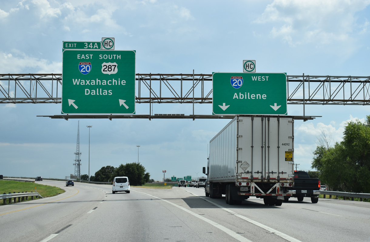
Traffic partitions at the south end of IH 820 for IH 20 across Forest Hill and south Fort Worth, IH 20 east to Arlington and Grand Prairie and U.S. 287 southeast through Kennedale. 08/06/19
![]() East at
East at ![]()
![]()

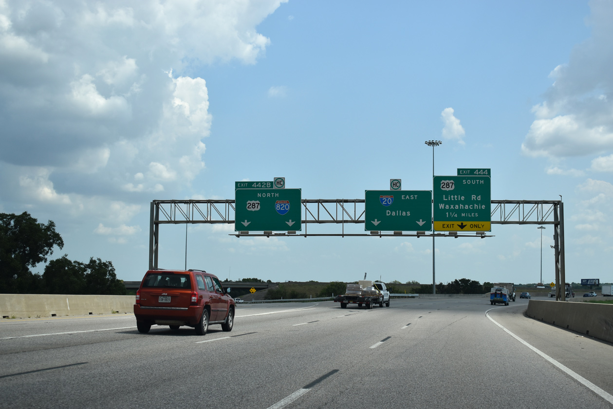
Through the city of Forest Hill, IH 20 drops below grade at Anglin Drive, one mile ahead of the exchange (Exit 442 B) with IH 820/U.S. 287 north. 08/06/19

Curving northeast over a Union Pacific Railroad line and U.S. 287 Business, IH 20 enters the three-wye interchange with IH 820/U.S. 287 along the Fort Worth and Kennedale city line. 08/06/19
U.S. 287 combines with IH 20 east from IH 820 briefly before the branching southeast along a freeway to Mansfield, Midlothian and Waaxhatchie. 08/06/19
![]() West
West ![]() North at
North at ![]()


Heading west from Arlington, U.S. 287 north briefly combines with IH 20 west to IH 820 north. The freeway passes just south of Lake Arlington and north of Kennedale on this stretch. 08/06/19

Exit 442 B departs IH 20 west for IH 820/U.S. 287 north. IH 820 travels west of Lake Arlington through east Fort Worth to Richland Hills. U.S. 287 branches northwest form nearby along the Martin Luther King, Jr. Freeway en route to Downtown Fort Worth. 08/06/19
West End – Benbrook, Texas
![]() South at
South at ![]()

Exit 1 A leaves IH 820 southbound for the Montserrat development in Fort Worth, a half mile ahead of IH 20. 08/06/19

IH 20 leads west from Fort Worth to the Parker County suburbs of Fort Worth, Weatherford and Abilene. 08/06/19


IH 20 overtakes the beltway east through Benbrook as IH 820 ends. 08/06/19
![]() East at
East at ![]()

IH 20 meets FM 2871 (Chapin School Road) by the Markum Ranch neighborhood, one mile west of IH 820. 08/06/19

A rural stretch through unincorporated Tarrant County precedes the directional T interchange (Exit 428) joining IH 20 eastbound with IH 820 north. 08/06/19

Exit 428 constitutes a sweeping flyover for IH 820 north to west Fort Worth and White Settlement. A cloverleaf interchange (Exit 429 A) follows along IH 20 with U.S. 377 (Benbrook Boulevard). 08/06/19
![]() West at
West at ![]()

U.S. 377 (Benbrook Boulevard) converges with IH 20 at Exit 429 A just south of the split with IH 820 at Exit 428. 08/06/19

Three lanes join the beltway north toward White Settlement while IH 20 reduces to two for the rural departure from the Fort Worth metropolitan area. 08/06/19

A c/d roadway provides access to both IH 20 west and IH 820 north from U.S. 377. Abilene lies 138 miles from this point. 08/06/19

Replaced overhead for the IH 820 north split from IH 20 west at the U.S. 377 (Benbrook Boulevard) overpass. Photo by Justin Cozart (08/02).
Historic West End – Overhill Road – Fort Worth, Texas

Advancing west to the separation with SH 183 (Southwest Boulevard) on IH 20 westbound. Both of these routes were originally IH 820, with SH 183 representing the original alignment for the Fort Worth loop. Photo by Justin Cozart (08/17/03).

SH 183 (Southwest Boulevard) north at Vickery Boulevard. The freeway transitions into an at-grade arterial just ahead. Photo by Justin Cozart (08/17/03).

An entrance ramp from Vickery Boulevard merges onto SH 183 north at the freeway end. The signalized intersection with Overhill Road is next. Photo by Justin Cozart (08/17/03).
Sources:
- Justin Cozart, email: “I-820 pre-1962 western end.” August 17, 2003.
- Texas Transportation Institute, page 34. From Anywhere to Everywhere: The Development of the Interstate Highway System in Texas. http://tti.tamu.edu/interstate_anniversary/white_paper/
Page updated August 16, 2019