Interstate 680 California

Overview
One of the busiest freeways in the East Bay, Interstate 680 connects the communities of Benicia, Concord, Walnut Creek, Danville, Sunol and San Jose. The section between Interstate 580 and the Benicia Bridge underwent extensive reconstruction through the late 1990s, resulting in an eight to ten lane freeway with carpool lanes.
Additionally Interstate 680 through the Sunol Grade was improved in 2001-2003. As part of the eight lane expansion, two bridges that were constructed in part for the planned interchange with SR 238 (Hayward Bypass/Mission Freeway) were removed.

Prior to the completion of I-280 and I-680 to their shared end point at U.S. 101, Temporary routes were posted along SR 17 through San Jose – 1968 California Official Map
The Solano I-80 I-680 SR 12 Interchange project at Fairfield addressed weaving traffic concerns, improved connectivity and expanded capacity. Work on the westbound connection from I-80 to SR 12 beyond I-680 was completed in 2017 as part of Package 1. Package 2A, the second of seven, replaced the single lane ramp from SR 12 east onto I-80 with a two lane bridge structure with accommodations for future project phases. A slip ramp from SR 12 to Green Valley Road ties into a braided off-ramp from I-80 east to I-680. Package 2A was originally scheduled for completion by Fall 2022.
 History
The Interstate 680 corridor was previously part of California State Route 21. Construction of the freeway gradually overtook the state route between San Jose and Fairfield in the 1960s and 1970s.
Prior to 1976, the northern most extent of Interstate 680 turned west from Benicia to I-80 at Vallejo. This changed with both the establishment of Interstate 780 along the former western leg to Vallejo and the extension of I-680 north over what was the remaining section of SR 21 between Benicia and I-80 at Coredlia.
The 1.2 mile long, Benicia-Martinez deck-truss Bridge over the Sacramento-San Joaquin River Delta was augmented with a parallel bridge. Started in 2001, this project involved the replacement of approaches for northbound traffic along with a new bridge structure located east of the original span. Following completion of the second span on August 25, 2007, the existing 1962 bridge was retrofitted to meet state seismic standards and restriped to carry southbound traffic. With the completion of the $1.2 billion project, the regular congestion that occurred as part of the reduced lanes, toll plazas, and the adjacent interchange with I-780 diminished.1
Route Information
North End – Fairfield, CA
South End – San Jose, CA
Mileage – 70.52
Cities – San Jose, Milpitas, Fremont, Walnut Creek, Concord
Junctions –


Source: December 31, 2021 Interstate Route Log and Finders List
I-680 Annual Average Daily Traffic (AADT)
Source: Caltrans 2017 Traffic Volumes : Route 505-980

State Route 21 was replaced by State Route 17 and Interstate 680 between San Jose and Cordelia. The last segment was transferred to I-680 in 1976.

Interstate 680 in San Jose was completed in 1974, two years after the opening of Interstate 280. I-680 was temporarily signed along State Route 17 to make the connection between San Jose and Fremont.
 Photo Guides
North End 
 – Fairfield, California
![]() North at
North at ![]()
![]()

Interstate 680 enters the trumpet interchange with I-80/SR 12 just north of the Cordelia Road underpass at Cordelia. 07/15/23

Exits 71 A-B separate from I-680 north for I-80/SR 12. 07/15/23
![]()
![]() West at
West at ![]()


Exit 41 departs I-80/SR 12 west for areas of southwest Fairfield at Green Valley a half mile ahead of Interstate 680. 07/11/18

I-680 traverses the lowlands of the California Delta before meeting Interstate 780 in Benicia and entering congested Contra Costa County, home of cities such as Martinez, Concord, Pleasant Hill, Walnut Creek and Danville. 07/11/18

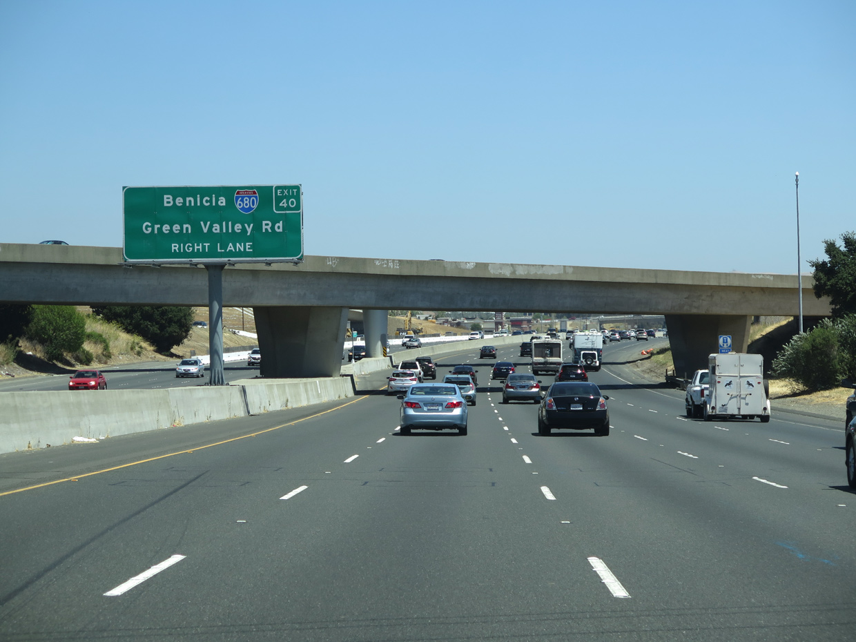
Two lanes follow for Interstate 680 south to the Benicia-Martinez Bridge and San Jose from I-80/SR 12 west at Exit 40. 07/11/18
![]()
![]() East at
East at ![]()

SR 12 combines with Interstate 80 eastbound at a wye interchange preceding the north end of I-680 at Green Valley in Fairfield. 07/15/23

A collector distributor roadway (Exit 40) separates from I-80 east beyond the flyover for SR 12 to both Green Valley Road and Interstate 680 south. 07/15/23

Two lanes leave the c/d roadway connecting I-80/SR 12 east with I-680 south for Green Valley Road to Cordelia. 07/15/23

A single lane advances along the c/d roadway from I-80 east at Exit 40 to I-680 south. The c/d roadway also connects Green Valley Road with Interstate 80 east. 07/15/23

South from I-80/SR 12, Interstate 680 straddles the eastern foothills of Sulpur Springs Mountain above wetland areas spreading west from Grizzly Bay. 07/15/23
 North End Throwback

Prior to I-80/I-680/SR12 Interchange Project: Package 2A, Exit 40 departed just beyond the entrance ramp bringing SR 12 east onto the freeway. This resulted in a short weaving traffic pattern. 07/24/16
The single lane flyover for SR 12 east was replaced with a two lane structure. The I-80/I-680/SR12 Interchange Project: Package 2A expanded SR 12 with separate ramps for Green Valley Road, I-680 and I-80 east. 07/24/16

The previous departure of Exit 40 for Interstate 680 south tied directly into the exchange with Green Valley Road north and Lopes Road south. 07/24/16


Replaced button copy signs for Interstate 680 south on I-80 / State Route 12 eastbound. 11/28/04

Right in right out (RIRO) ramps previously linked the c/d roadway at Exit 40 with Green Valley Road. A parallel off-ramp was constructed further back, eliminating the sharp off-ramp pictured here. 11/28/04

A new overpass was constructed for Green Valley Road, and the ramp for Interstate 680 south to Concord, Walnut Creek and San Jose was realigned. 11/28/04

A porcelain enamel overhead formerly posted at the north end of I-680 for I-80/SR 12 west. 06/21/15
South End – San Jose, California
![]() South at
South at ![]()
![]()

I-680 south turns west from Alum Rock, San Jose between North Valley and East San Jose toward U.S. 101 and the transition to Interstate 280 north. 03/27/16

Exit 1C departs for King Road and the Mayfair and the Gateway East neighborhoods just ahead of the four-level interchange (Exit 1B) with U.S. 101 (Bayshore Freeway). U.S. 101 links San Jose with San Francisco to the north and Salinas to the south. 03/27/16

U.S. 101 leads west from I-280 / 680 to Santa Clara and Sunnyvale and southeast to Edenvale and Santa Teresa in south San Jose. 03/27/16
![]() South at
South at ![]()
![]()


Southbound Interstate 280 at the systems interchange with U.S. 101 and transition to I-680 north. 11/25/07
![]() North at
North at ![]()
![]()

Two miles southeast of I-280/I-680 on U.S. 101 northbound at the six-ramp parclo interchange with Capitol Expressway. 03/25/16

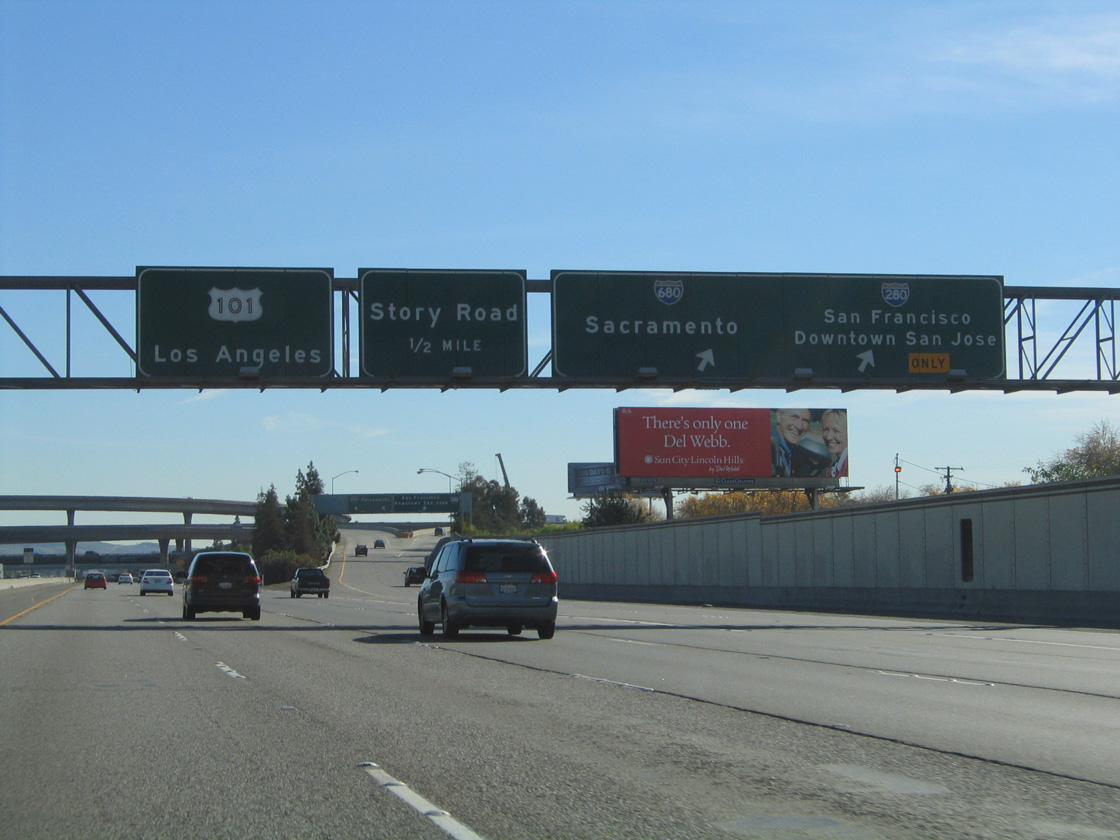
Exit 383 departs from U.S. 101 north to Tully Road. Four lanes continue north one mile to I-280 north to San Francisco and I-680 north to Walnut Creek. This set of button copy signs was replaced by 2013 to incorporate exit numbers. 12/23/04

North of Tully Road, U.S. 101 expands to six lanes leading into the cloverstack interchange (Exit 384) with I-280 west to Sunnyvale and I-680 north to Milpitas and Fremont. 03/25/16

Exit 384 departs U.S. 101 northbound, taking motorists onto Interstate 680 north to Milpitas and Fremont and I-280 west to Sunnyvale and north to Daly City. 12/23/04

Story Road and high speed flyovers linking with I-280 and I-680 with U.S. 101 pass overhead 0.75 miles beyond the gore point for Exit 384. 12/23/04
![]() South at
South at ![]()
![]()
Southbound U.S. 101 reaches Exit 385B for I-280 and I-680 north. Interstate 280 initially travels west through Silicon Valley before it turns north toward San Francisco. 11/29/04
Sources:
- Metropolitan Transportation Commission (MTC). (2026, January 1). Benicia-Martinez Bridge. https://mtc.ca.gov/operations/programs-projects/bridges/benicia-martinez-bridge
Page updated October 3, 2023.