Interstate 581 Virginia

Overview
Interstate 581 is a spur leading south from I-81 to Roanoke–Blacksburg Regional Airport (ROA) and the independent city of Roanoke. The urban freeway is cosigned with U.S. 220 as part of its route between Martinsville and Covington. I-581 is also incorporated in the Future Interstate 73 corridor through Virginia.
Exit numbers along Interstate 581 utilize cardinal direction based suffixes. Interchange numbers increase from north to south, contrary to standard Interstate numbering.
 History
Interstate 581 was part of the urban Interstate numerology submitted by the Virginia Department of Highways to the American Association of State Highway Officials (AASHO) on July 16, 1958 and formally approved on November 10, 1958. Traffic and Planning Division Maps produced in April 1958 identified the spur into Roanoke as Interstate Route U2, where U stood for urban. I-381 was Interstate Route U1.
Interstate 581 opened initially from I-81 south to Virginia Route 117 (Peters Creek Road) in November 1964, and south to U.S. 460/11 Alternate and Virginia Route 116 (Orange Avenue) by September 1965. Completion of the route southward to SR 24 (Elm Avenue) occurred by October 1967.1
The Valley View Interchange along I-581/U.S. 220 at Exit 3C was the second diverging diamond constructed in the state of Virginia. The DDI replaced a partial exit built in 1999. Benefiting holiday shoppers bound for adjacent Valley View Mall, the exchange opened to traffic following a ribbon cutting ceremony held on November 21, 2016.2 Design-build contracts for the $63.9 million project were awarded in March 2013. Work commenced in Summer 2014.3
Future Interstate 73 corridor signs for I-581/U.S. 220 were unveiled at a news conference held by the City of Roanoke on April 3, 2015. The announcement followed efforts from Senator Bill Stanley (R-Franklin County), who sponsored a bill that established the I-73 Federal Transportation Compact. The partnership coordinates funding, development and construction of the Interstate corridor between Michigan, Ohio, West Virginia and the Carolinas. The Virginia Department of Transportation (VDOT) estimated at the time that it will cost $4 billion to complete the highway within the Commonwealth.4
Route Information
North End – Roanoke, VA
South End – Roanoke, VA
Mileage – 6.64
Cities – Roanoke
- Junctions –

Source: December 31, 2021 Interstate Route Log and Finders List
I-581 Annual Average Daily Traffic (AADT)
Source: 2019 VDOT Traffic Volume

Interstate 581 under construction from I-81 southeast to U.S. 460 (Orange Avenue) – 1963 Virginia Official Highway Map

The southernmost section of I-581 under construction in 1967. Subsequent freeway segments built south were only designated as new alignments of U.S. 220.
 Photo Guides
North End 
 – north of Roanoke, Virginia
![]()
![]() North at
North at ![]()

I-581/U.S. 220 run along the west side of Roanoke-Blacksburg Regional Airport (ROA) north to SR 117 (Peters Creek Road). 05/27/21
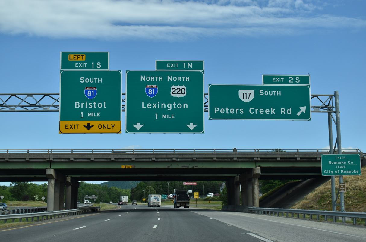
A cloverleaf interchange (Exit 2) joins I-581/U.S. 220 with SR 117 (Peters Creek Road) along the Roanoke city line, one mile south of the exchange with Interstate 81. 05/27/21

U.S. 220 combines with Interstate 81 north from Exit 1N to U.S. 11/220 ALT at Daleville. I-81 continues northeast from there to I-64 outside Lexington. 05/27/21

Left Exit 1S joins Interstate 81 south ahead of SR 419 (Electric Road) at the city of Salem. I-81 joins Roanoke with I-77 at Wytheville and Bristol. 05/27/21

Previous overheads at the north end of Interstate 581. 07/24/04

The three-wye interchange joining I-581 and I-81 was constructed in 1963. 05/27/21
![]() North at
North at ![]()
![]()

Costing $38 million, construction from Spring 2020 to Summer 2022 expands I-81 with auxiliary lanes in both directions between Exit 141 with SR 419 (Electric Road) and Exit 143 with I-581/U.S. 220 south. 05/26/21

Interstate 81 advances northeast between Green Ridge and the Willow Green subdivision to Exit 143 for I-581/U.S. 220 south to the city of Roanoke. 08/06/13
![]()
![]() South at
South at ![]()

I-81/U.S. 220 straddle the east slope of Green Ridge southwest to Left Exit 143 for Interstate 581 south. 05/27/21

I-81/U.S. 220 run north of the Buckland Forest and Belle Haven subdivisions one mile to Left Exit 143 for Interstate 581 south. 08/06/13

U.S. 220 overlaps with I-81 south 6.45 miles from Daleville and to I-581 at Left Exit 143. U.S. 220 historically combined with U.S. 11 south from Hollins to Downtown Roanoke. 05/27/21

U.S. 220 combines with Interstate 581 for 6.57 miles to SR 24 (Elm Avenue). U.S. 220 extends south from Downtown Raonoke to Martinsville and Greensboro, North Carolina along the future I-73 corridor. 05/27/21
South End – Roanoke, Virginia
![]()
![]() South at
South at ![]()

Advancing south from U.S. 11/221-SR 116 (Williamson Road), I-581/U.S. 220 elevate along a viaduct over the Norfolk Southern Roanoke Shops rail facility to Exit 6 for SR 24 (Elm Avenue). 08/06/13

SR 24 ends just west of Exit 6 at SR 116 (Williamson Road). SR 24 leads east from Downtown Roanoke to the town of Vinton. 05/27/21

Milepost zero and an end shield for I-581 stand below the Elm Avenue overpass. U.S. 220 extends the freeway south from the diamond interchange (Exit 6) with SR 24 to South Roanoke and Cave Spring. 05/27/21
![]() North at
North at ![]()
![]()

U.S. 220 angles northeast toward Downtown Roanoke, meeting Wonju Street 1.75 miles ahead of Interstate 581. 05/27/21

U.S. 220 shifts east from SR 116 (Walnut Avenue) to the diamond interchange (Exit 6) with SR 24 (Elm Avenue) by the Cedar Bluff neighborhood. 05/27/21

Interstate 581 commences northbound alongside U.S. 220 at the exchange with SR 24 (Elm Avenue) by Downtown Roanoke. 05/27/21
Sources:
- Roberson, M. (2014, December 6). I-581. Virginia Highways Page. http://www.vahighways.com/route-log/i581.htm
- Valley View Interchange project to finish in time for Black Friday. (2016, November 16). WDBJ.
- Virginia Department of Transportation (VDOT). Interstate 581 and Valley View Interchange Improvements. Retrieved November 28, 2016 from http://www.virginiadot.org/projects/salem/valley_view_interchange.asp
- Roanoke unveils new sign pushing future Interstate 73. (2015, April 4). WSLS TV-10. https://www.wsls.com/economy/2015/04/04/roanoke-unveils-new-sign-pushing-future-interstate-73/
Page updated July 14, 2021.