Interstate 430 Arkansas

Overview
Joining I-30 with I-40, Interstate 430 provides a both a western bypass of Little Rock and a commuter route. The I-430 bridge across the Arkansas River is the lone crossing of the waterway between Downtown Little Rock and Conway, some 25 miles to the northwest.
 History
Early plans for both Interstate 430 and I-630 in western Little Rock originated in the mid 1950s. During that time period, University Avenue represented the western extent of the built up area of the capital city. Interstate 430 was constructed initially from Markham Street in west Little Rock to I-40 near Crystal Hill. The route was completed in 1975 at a total cost of $67 million.
The Big Rock Interchange, where I-430 converges with the west end of I-630, opened in 1977. Rapid development along the west side of the exchange resulted in a 400% increase of traffic within the vicinity along both freeways. The Arkansas Highway Commission authorized a study for area improvements in 2004. Plans for the interchange upgrade were announced in 2006.1
The first of three construction phases to rebuild the Big Rock Interchange commenced in January 2009.1 The third phase added two high speed flyovers. The interchange name was derived from a 5 million pound rock formation uncovered during construction. The nearly $150 million project was dedicated on July 8, 2015.2
The diamond interchange (Exit 5) with Shackleford Road on Interstate 430 was added sometime between 1982 to 1984. The addition of the exchange at Exit 5 coincided with expansion of I-430 to eight overall lanes northward from Shackleford Road to Rodney Parham Road (Exit 8).3
Route Information
North End – North Little Rock, AR
South End – Little Rock, AR
Mileage – 13.35
Cities – Little Rock, North Little Rock
- Junctions –


I-430 Annual Average Daily Traffic (AADT)

No control point was used on older guide signs for I-430 on Interstate 40. 05/30/95

Little Rock – 1971
Interstate 430 was under construction from I-40 southwest to Marham Street. I-630 was only open at this time between the couplet of Cedar and Pine Streets and the State Capitol at Park Street.
 Photo Guides
North End  – North Little Rock, Arkansas
![]() North at
North at ![]()
![]()


Crossing Murray Lake along the Arkansas River, Interstate 430 converges with AR 100 at a diamond interchange (Exit 12) preceding I-40 in North Little Rock. 09/09/20


Left Exit 13B separates with two lanes from the north end of I-430 to Interstate 40 west 21 miles to Conway. Exit 13A joins a c/d roadway along I-40 east ahead of Highway 100 in North Little Rock. 09/09/20
![]() East
East ![]() South at
South at ![]()

Eastbound I-40 expands to four lanes from White Oak Crossing at Padgett Mountain southward to the directional T interchange (Exit 147) with Interstate 430. 09/09/20

Entering the city of North Little Rock, Exit 147 departs from I-40 east / U.S. 65 south for Interstate 430 south to west Little Rock and I-30 to Texarkana. 09/09/20
![]() West
West ![]() North at
North at ![]()

Interstate 40 west / U.S. 65 north navigate a pair of S-curves through Burns Park to AR 100 (Crystal Hill Road) at Crystal Hill. I-430 follows in one mile. 09/09/20

Exit 148 departs I-40 west / U.S. 65 north for Highway 100 (Crystal Hill Road). Highway 100 originates at Exit 148 and loops northwest through Maumelle. 09/09/20
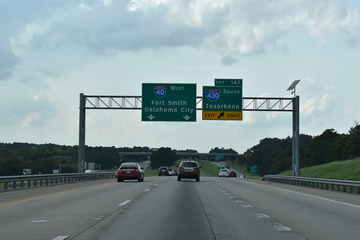
A lane drop occurs at the succeeding slip ramp (Exit 147) for Interstate 430. 09/09/20
The entrance ramp from Highway 100 forms a collector distributor roadway to the directional T interchange (Exit 147) with Interstate 430 south. 09/09/20
 North End Throwback
![]() North at
North at ![]()
![]()


Six lane expansion underway in 2014-16 along I-40 west from Interstate 430 to Highway 365 at Maumelle included extending the third northbound lane on I-430 from Highway 100 to Exit 13B. 05/20/14
![]() East
East ![]() South at
South at ![]()

A diamond interchange (Exit 146) was constructed along I-40 at White Oak Crossing, 1.25 miles north of Interstate 430. Costing $14.6 million, the exchange opened to commuters on November 7, 2019.7 05/07/12

The Norman Road overpass was replaced during widening of I-40 from four to eight lanes between White Oak Crossing and Interstate 430 south. 05/07/12
![]() West
West ![]() North at
North at ![]()

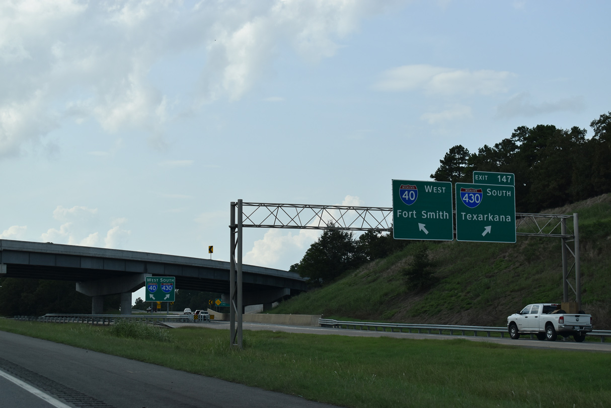
Guide signs for I-430 were replaced in 2016 and show Texarkana for the connection with I-30 west 05/07/12

The c/d roadway at Exit 147 partitions for I-40 west to Conway and Fort Smith and I-430 south into west Little Rock. 05/07/12
South End – Little Rock, Arkansas
![]() South at
South at ![]()
![]()
![]()


Southbound Interstate 430 meets AR 5 (Stagecoach Road) at a diamond interchange (Exit 1) along the eastern foothills of Ellis Mountain. Three lanes proceed southward 1.25 miles to Interstate 30. 09/09/20

2014-16 widening of I-430 south from AR 5 to Interstate 30 added an auxiliary lane to the exit ramp built for the I-30 Frontage Road at Gateway Town Center. 09/09/20

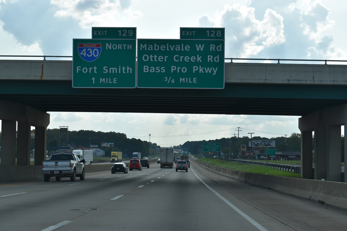
Exit 128 departs for I-30 Frontage Road west to Bass Pro Parkway and Mabelvale W Road nearby. Exit 129B follows for Interstate 30 west to Benton, Hot Springs and Texarkana. 09/09/20

Interstate 430 concludes at a trumpet interchange (Exit 129) with I-30 west to Dallas, Texas and east toward Downtown Little Rock. 09/09/20
![]()
![]() East
East ![]() North at
North at ![]()

Two miles southwest of Interstate 430 (Exit 129) on I-30 eastbound. The ensuing interchange connects with Mabelvale West and Otter Creek Roads. 05/20/14

A frontage road system accompanies Interstate 30 east from Exit 116 at Benton to 65th Street (Exit 135) in Little Rock. The four roadways pass under Vinny Ridge Road one mile out from Interstate 430 north. 05/20/14

A slip ramp (Exit 128) links with the I-30 frontage road ahead of Mabelvale West Road and the Outets of Little Rock retail center located west of I-430. 05/20/14

Interstate 430 provides a bypass of Little Rock north to I-40 northwest to Conway, Russellville and Fort Smith. 05/20/14

Entering the trumpet interchange (Exit 129) with I-30-U.S. 70 east and U.S. 67 north. 05/20/14
![]()
![]() West
West ![]() South at
South at ![]()

Exit 131 departs from I-30/U.S. 67-70 westbound to McDaniel Drive 2.25 miles ahead of Interstate 430 north. 09/09/20

AR 338 (Baseline Road) crosses I-30 at Mabelvine in Little Rock west to AR 5 (Stagecoach Road) beyond Interstate 430. 09/09/20
The new westbound off-ramp at Exit 128 opened to motorists on December 17, 2014.4 09/09/20

Exit 128 constitutes a slip ramp to the north side frontage road a half mile east of Interstate 430. 09/09/20

Exit 129 parts ways with I-30/U.S. 67-70 west for Interstate 430 through west Little Rock to North Little Rock. 09/09/20
South End Throwback
![]() South at
South at ![]()
![]()
![]()

Initial overheads for Interstate 30 along I-430 south were replaced in kind between July and October 2016. 05/07/12

Interstate 430 previously reduced to two southbound lanes beyond Fourche Creek. Exit 128 to the north side frontage road for I-30 opened along this stretch in December 2014. 05/07/12

Construction in 2016 widened Exit 129B for I-30 west to two lanes. 05/07/12
![]()
![]() West
West ![]() South at
South at ![]()


All guide signs for Interstate 430 along I-30 from the Mabelvale Pike overpass westward were replaced during construction to relocate Exit 128 to Otter Creek. 05/20/14
Sources:
- Big Rock Interchange Fact Sheet.
http://arkansashighways.com/430_630_Project/Facts_7_8_15.pdfArkansas Department of Transportation (ARDOT). - “Big Rock Interchange dedicated.” Arkansas Democrat Gazette (Little Rock, AR), July 8, 2015.
- Price, John; Personal Email, “RE: I-30 Little Rock/Benton 3-lane nears completion” (03/24/06)
- “New I-30 Exit Ramp Opening in LR’s Otter Creek.” Fox16 (Little Rock, AR), December 17, 2014.
- “I-430 interchange widening complete, I-630 widening now on the horizon.” KATV (Little Rock, AR), November 16, 2016.
- I-40: Pulaski County – Connecting Arkansas Program. – Arkansas Department of Transportation (ArDOT), web page.
- I-40 project to give fast-growing central Arkansas city its long-sought ‘third entrance’ Arkansas Democrat-Gazette (Little Rock), October 25, 2018.
Page updated September 26, 2020.