Interstate 291 Massachusetts

Overview
Joining I-91 and Downtown with I-90 and the Mass Pike, Interstate 291 forms an urban loop through the city of Springfield. The freeway is six lanes wide east to Exit 4 / St. James Avenue and four lanes from there north into the city of Chicopee. The connection with the Massachusetts Turnpike is substandard with an at grade intersection joining the access road to I-90 from the freeway end at Burnett Road.
Massachusetts Department of Transportation (massDOT) project #606599 reconstructed the ramp (Exit 51) joining I-90 (Mass Pike) with I-291 and expanded the intersection with Burnett Road. Costing $8.373 million, the notice to proceed for work was issued on February 12, 2021.3
 History
Initial plans for Interstate 291 got underway in 1953, with construction starting the following year. The freeway opened between Interstate 90 and U.S. 20 / Massachusetts Route 20A in 1957. Ensuing work on I-291 did not commence until 1967.1 The final section of I-291 built was a 2.1 mile long segment in Springfield at an estimated cost of $5 million in 1968.2 The last section was completed in 1970.1
The Massachusetts Department of Public Works suggested Route 91C for the proposed loop in Springfield to the American Association of State Highway Officials (AASHO) on April 10, 1958:
This route is a connector between Interstate Routes 90 and 91 in Springfield and is an urban route. The letter “C” was chosen to indicate that this location is a connector between two Interstate routes.
Route 91C was changed to Interstate 291 as part of the proposed numerology for urban areas on the Interstate System for Massachusetts approved by the American Association of State Highway Officials (AASHO) on August 29, 1958.
Route Information
East End – Chicopee, MA
West End – Springfield, MA
Mileage – 5.44
Cities – Chicopee, Springfield
Junctions –


Source: December 31, 2021 Interstate Route Log and Finders List
I-291 Annual Average Daily Traffic (AADT)
Source: 2015-17 MassDOT Transportation Data Management System

Interstate 291 was originally projected for completion by late 1969 across the city of Springfield, Massachusetts.
 Photo Guides
East End 
 / Burnett Road – Chicopee, Massachusetts
![]() East at
East at ![]()
![]()

The first reference of the Mass Pike on Interstate 291 eastbound precedes the separation with U.S. 20 at Exit 5A for Page Boulevard. 05/31/22

An end sign for Interstate 291 east stands ahead of the Roosevelt Avenue overpass in East Springfield. 05/31/22
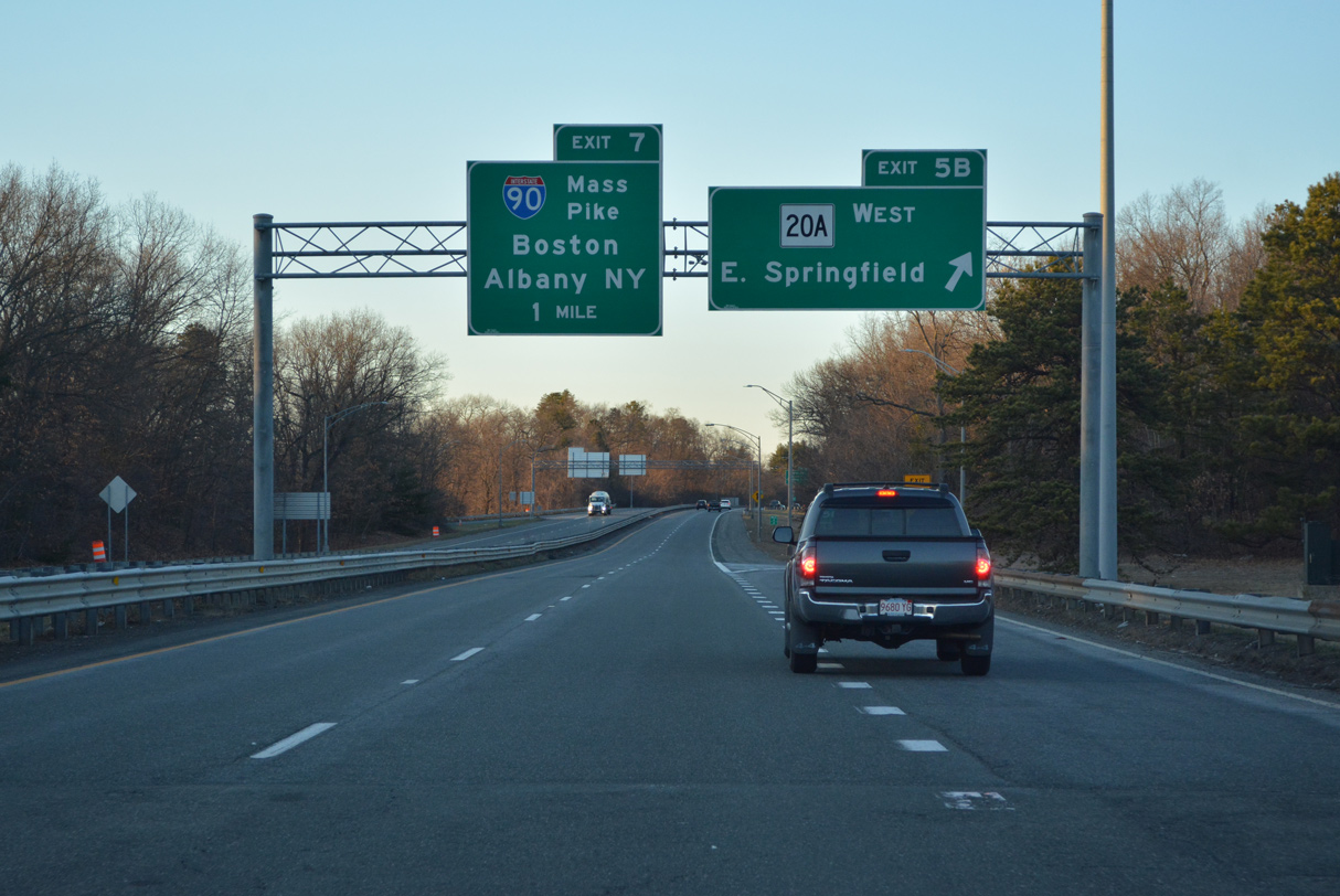
Exit 5 B loops onto Route 20A (Page Boulevard) west to Liberty Heights in Springfield one mile from the end of I-291 at Exit 7. 05/31/22

I-291 spans both Route 141 (E Main Street) and the Chicopee River ahead of the Mass Pike (I-90) and east of Chicopee Falls. 03/26/23

Interstate 291 advances north from the folded diamond interchange (Exit 6) with Fuller Road to the turn off (Exit 7) for the Mass Pike access road. 03/26/23

A Breezewood connection joins Interstate 291 (Springfield Expressway) with the Mass Pike. 03/26/23

Construction from Winter 2021 to Fall 2022 rebuilt the intersection joining the east end of I-291 and Burnett Road south with the Mass Pike access road to Interstate 90 at Exit 51. 03/26/23

The Mass Pike leads Interstate 90 west toward Albany, New York and east to Worcester and Boston. 03/26/23
![]()
![]() East at
East at ![]()

The Mass Pike continues two miles east from Exit 49 for Route 33 in Chicopee to the East Springfield Interchange (Exit 51) with I-291 and Burnett Road. 03/26/23

The Mass Pike parallels the Chicopee River and Fuller Road east to Exit 51 for I-291 (Springfield Expressway) west and Burnett Road east. 03/26/23

Hartford, Connecticut is used as a control point for I-291 west instead of for I-91 from I-90 east. 03/26/23

Interstate 291 arcs southwest from Exit 51 at Chicopee into the Massachusetts capital city at East Springfield. 03/26/23
![]()
![]() West at
West at ![]()

Interstate 291 is the first of three interchanges along the Mass Pike westbound for Springfield. Photo by Doug Kerr (06/30/13).

Interstate 291 provides a more direct route to I-91 south to Hartford, Connecticut then remaining on I-90/Mass Pike west to Exit 45. Photo by Doug Kerr (06/30/13).

Burnett Road ties into the access road from the trumpet interchange at Exit 51 west from Holyoke Street and the town of Ludlow. 03/26/23
Exit 51 was expanded into a triple left turn lane for I-291 west as part of road construction underway from Winter 2021 to Fall 2022. 03/26/23
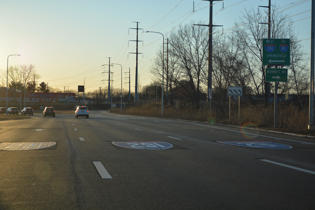
A signalized turn links both directions of I-90 at Exit 51 with I-291 (Springfield Expressway) west in Chicopee. Burnett Road leads north to nearby Chicopee Memorial State Park. 03/26/23

Previous button copy sign at the intersection joining the access road from the Mass Pike to I-291 west at Burnett Road. Photo by Shawn De Cesari (12/99).
![]() West
West

Burnett Road curves southward by an industrial park to become Interstate 291 at the intersection with the access road to the Mass Pike (I-90). 03/26/23

A begin shield for Interstate 291 west stands at the Chicopee River south of the exchange with Fuller Road. 03/26/23
West End – Springfield, Massachusetts
![]()
![]() West at
West at ![]()

The first overhead for Exits 1 B/A to Interstate 91 on I-291/U.S. 20 west precedes Exit 4 to St. James Avenue and Chicopee Falls. 05/31/22
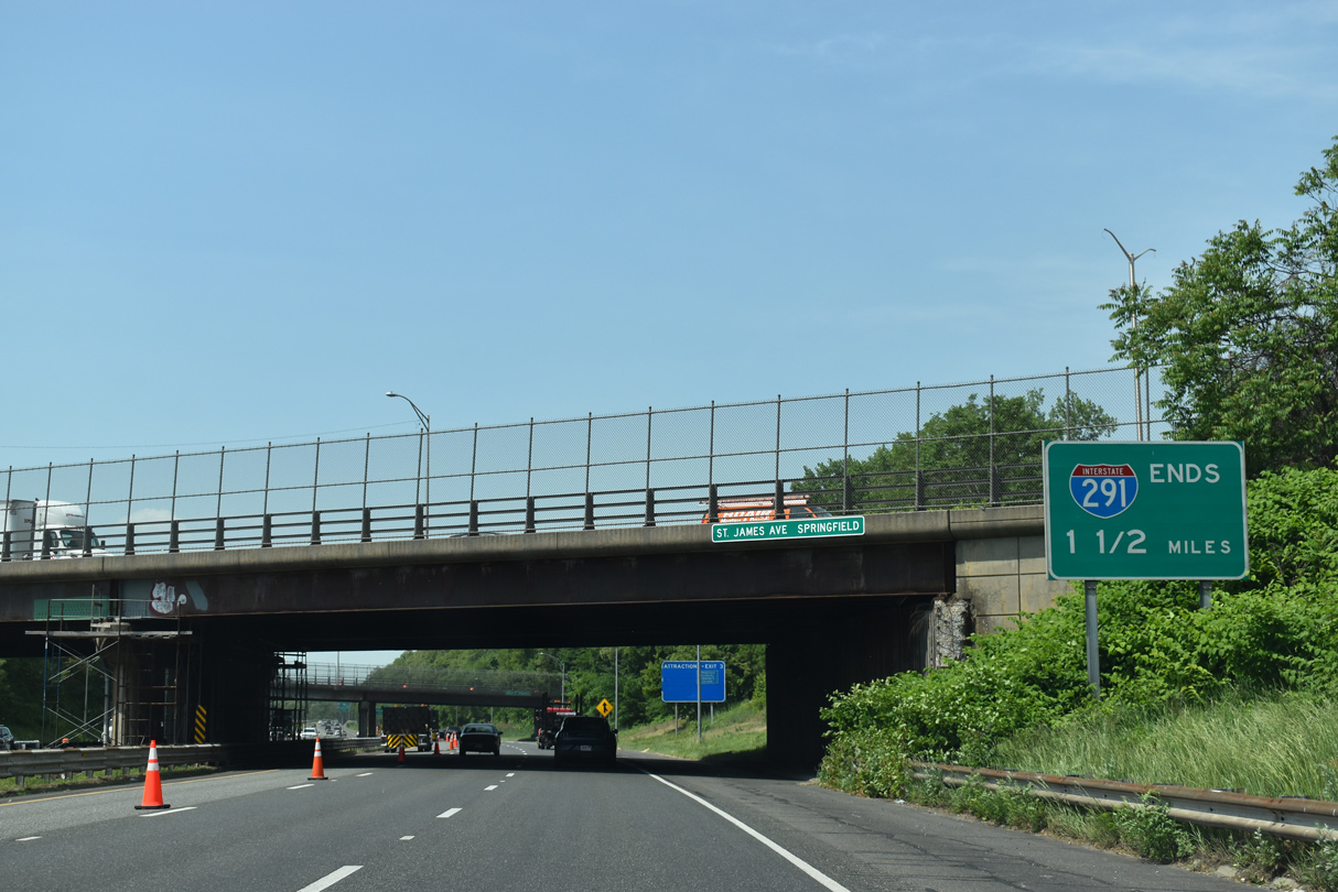
An end sign for Interstate 291 appears westbound at the St. James Avenue overpass. 05/31/22

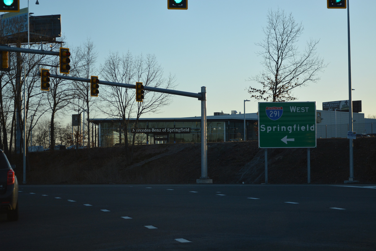
A full-Y interchange joins I-291 and U.S. 20 with I-91 at Pynchon Park along the Connecticut River in one mile. 05/31/22

Amory and Liberty Streets span I-291/U.S. 20 one half mile ahead of their split at Interstate 91. Forthcoming Exit 2 B leaves with Exit 1 B for I-91 north and Dwight Street. Exit 2 A departs with Exit 1 A for I-91 south and Chestnut Street. U.S. 20 follows the I-91 ramp system north to Plainfield Street. 05/31/22

A fourth lane opens along I-291/U.S. 20 westbound from the Liberty Street entrance ramp. Ensuing ramps at Exit 2 B for Dwight Street (Exit 2 B) and Exit 2 A for Chestnut Street link I-291 with the Springfield central business district to the south. 05/31/22

U.S. 20 westbound departs at Exit 1 B to the North End Bridge and West Springfield. I-91 north travels 1.50 miles to split with Interstate 391 at Chicopee. I-391 spurs north 4.46 miles to U.S. 202 in Holyoke. 05/31/22

The ramp for I-91 north also connects with Dwight Street (Exit 2 B) while the connection to I-91 south and U.S. 20 west includes a loop ramp (Exit 2 A) for Chestnut Street south. Dwight Street intersects Route 20A (Carew Street) two blocks to the north. 05/31/22
![]() North at
North at ![]()
![]()

A collector distributor roadway joins ramps from Route 83 and U.S. 5 onto I-91 north, two miles ahead of the directional T interchange (Exit 6) with Interstate 291 and U.S. 20 east. 05/31/22

Interstate 91 runs along the Connecticut River north past the Naismith Memorial Basketball Hall of Fame and the South End neighborhood to I-291/U.S. 20 at Downtown Springfield. 05/31/22

U.S. 20 overlaps with the urban loop from Plainfield Street and I-91 to Page Boulevard at East Springfield. 05/31/22

Parallel Route 20A along Carew Street and St. James Boulevard represents the former U.S. 20 alignment through Springfield. 05/31/22

Two lanes depart from an elevated section of Interstate 91 north for I-291/U.S. 20 east at Exit 6. U.S. 20 ties into I-91/291 from West Springfield. 05/31/22
![]() South at
South at ![]()
![]()

I-91 advances 1.5 miles from the south end of Interstate 391 in Chicopee to the west end of I-291 in Springfield. 05/31/22

Exit 8 leaves Interstate 91 south well ahead of the parclo interchange with U.S. 20 at Plainfield Street. The off-ramp connects with parallel Birnie Avenue south to U.S. 20 at the North End Bridge to West Springfield. 05/31/22

Four lanes progress southward from Exit 6 to the flyover for I-291/U.S. 20 east to the Mass Pike at Chicopee. 05/31/22

U.S. 20 combines with Interstate 291 east from a distributor roadway extending south from Birnie Avenue and Plainfield Street into the exchange at Exit 6. 05/31/22

U.S. 20 joins I-291 east from Plainfield Street along the flyover at Exit 6. I-91 continues southwest along Downtown Springfield while I-291/U.S. 20 pass north of Metro Center. 05/31/22
![]()
![]() East
East

The flyover from I-91 south to I-291/U.S. 20 east connects with Chestnut Street (Exit 2) before merging with the ramp from I-91 north. The two roadways from I-91 converge beyond a begin shield assembly for Interstate 291 east. 05/31/22
Sources:
- Anderson, S. (n.d.). Springfield Expressway (I-291). BostonRoads.com. http://www.bostonroads.com/roads/I-291_MA/
- 4 Highway Projects in Making. (1966, November 10). The North Adams Transcript.
- Massachusetts Department of Transportation (massDOT). Information about project #606599. https://hwy.massdot.state.ma.us/projectinfo/hearings-pinfo.asp?num=606599
Page updated April 3, 2023.