Interstate 905 California

Overview
California State Route 905 follows the Otay Mesa Freeway east across southern San Diego from Tocayo Avenue and Interstate 5 in the San Ysidro area to the International Border at Otay Mesa. A major commercial route, SR 905 is the main gateway for trucks into Mexico, as trucks are prohibited at the San Ysidro Port of Entry connecting with I-5/805. Despite completion of the freeway from I-5 to the Otay Mesa port of entry on July 30, 2012, the Otay Mesa Freeway remains a state route.
Per an agreement between the California Department of Transportation (Caltrans) and the Federal Highway Administration (FHWA), it is expected that SR 905 will be upgraded to Interstate 905 in the future. FHWA informally approved nonchargeable Interstate status for the route, and the American Association of State Highway and Transportation Officials (AASHTO) approved the designation of Interstate 905 on December 7, 1984. Correspondence between Caltrans and AASHTO on October 24, 1984 requested Interstate 905 as follows:
Designation of a segment of State Route 117 and a segment of State Route 125 as I-905 between I-5 in San Diego and the International Border at Tijuana, Mexico.
(This route is 8.8 miles in length and will connect to a new border crossing which will relieve the congestion at the existing Interstate 5, San Ysidro crossing.)
High Priority Corridor
California State Route 905 is part of High Priority Corridor 30: Camino Real for its entire length.
 History
Otay Mesa was expanded to six lanes by 2000 with $20 million in state and local funds.1 The first section of SR 905 upgraded to freeway standards east of San Ysidro was the interchange with Siempre Viva Road (Exit 9). This exchange was completed in 2005. Upgrades for the remainder of SR 905 were originally slated for 2006 or 2007, but funding constraints partitioned construction into four separate projects.
Costing $441 million, work on SR 905 commenced with Phase 1A in April 2008. Phase 1A included construction of the six lane freeway between Siempre Viva Road and Britannia Boulevard on a new alignment south of Otay Mesa Road. It also upgraded SR 905 north of Exit 9 to Airway Road. It was completed in December 2010.1</sup
Underway from July 2009 to July 30, 2012, Phase 1B followed with construction of the six lane highway from Britannia Boulevard west to the previous freeway end near Interstate 805. Started in May 2011 and completed in February 2012, Phase 2 focused on improvements at the cloverstack interchange connecting SR 905 with I-805.1
Subsequent work added an interchange with SR 11, a toll road planned from SR 905 and SR 125 (South Bay Expressway) east to a new port of entry. A partial exchange was completed at SR 11/125/905 on November 30, 2016.2
A westerly extension of SR 905 through Border Field State Park and the Tia Juana River Valley was proposed legislatively. However, the extension remains unconstructed due to environmental concerns.
Route Information
East End – San Diego, CA
West End – San Diego, CA
Mileage – 8.89
Cities – San Diego
- Junctions –


Source: Caltrans Postmile Services
SR 905 Annual Average Daily Traffic (AADT)
Source: 2017 Traffic Volumes – Caltrans Traffic Census Program

Construction of the parclo A2 interchange joining La Media Road with SR 905 (Otay Mesa Freeway). 07/12/09


Some of the first reflectorized signs installed along Interstate 5 in San Diego prematurely referenced SR 905 as Interstate 905. These were quickly amended in the ensuing weeks. 09/01/03
 Photo Guides
East End – International Border – Otay Mesa Port of Entry (San Diego), California
![]() East at Otay Mesa Port of Entry
East at Otay Mesa Port of Entry

SR 905 was upgraded to freeway standards from the parclo interchange (Exit 9) with Siempre Viva Road to the port of entry in Fall 2005. 07/09/18

Siempre Viva Road connects the SR 905 (Otay Mesa Freeway) with the commercial port of entry to the east and a number of warehouses and shipping facilities. 07/09/18

A U-turn provides return access to SR 905 (Otay Mesa Freeway) westbound just ahead of the port of entry and international border. 07/09/18
A U-turn provides return access to SR 905 (Otay Mesa Freeway) westbound just ahead of the port of entry and international border. 07/09/18

Continuing south into Mexico is the Otay Mesa section of Tijuana, located just east of Tijuana International Airport (TIJ). 07/09/18
![]() West
West

SR 905 enters the parclo interchange (Exit 9) with Siempre Viva Road immediately north of the Otay Mesa port of entry. Completed in Fall 2005, this exchange replaced an at-grade intersection. 07/09/18

A welcome to California sign stands beyond the gore point for Siempre Viva Road. 07/09/18
West End  – Otay Mesa West (San Diego), California
![]() West at
West at ![]()
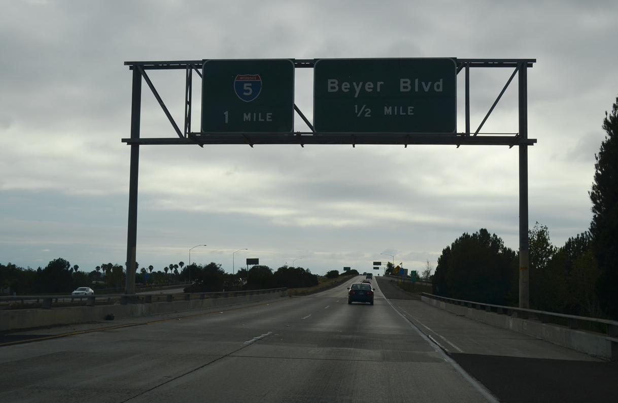
Dense residential development lines both sides of SR 905 (Otay Mesa Freeway) leading west from I-805 to I-5. Exit 1C joins the freeway with Beyer Road, the historic alignment of U.S. 101 south into San Ysidro. 07/19/14

The entrance ramp from Beyer Boulevard forms an auxiliary lane for I-5 south to Tijuana and the west end of SR 905 at Orlo Vista Road. 07/19/14

The westbound SR 905 mainline defaults onto Interstate 5 north toward Chula Vista, National City and Downtown San Diego. 07/19/14

A loop ramp (Exit 1B) connects SR 905 west with Interstate 5 south to San Ysidro and the international border. 07/12/09

SR 905 concludes a third of a mile beyond Exit 1B at Tocayo Avenue and Oro Vista Road. 07/12/09

An end shield stands at the signalized intersection with Tocayo Avenue west and Oro Vista Road. Oro Vista Road connects the freeway end with subdivisions to the south and duplexes to the north. Tocayo Avenue extends west to Hollister Street and an adjacent neighborhood. 07/12/09
![]() East at
East at ![]()
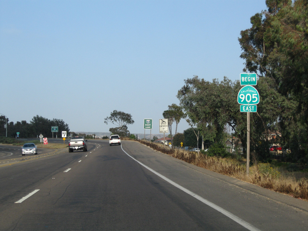
Eastbound SR 905 begins at the intersection of Tocayo Avenue and Oro Vista Road, just ahead of Interstate 5. 06/18/09

SR 905 enters a cloverstack interchange with Interstate 5 to the immediate east of Oro Vista Road. 06/18/09

A loop ramp follows for Interstate 5 north to Chula Vista, National City and Downtown San Diego. Replaced by 2019, button copy signs here predate the upgrade of Otay Mesa Road to a freeway. 06/18/09
![]() South at
South at ![]()

Interstate 5 advances 0.75 miles south from Coronado Avenue to the cloverstack interchange (Exit 4) with the Otay Mesa Freeway. 07/09/18

Southbound Interstate 5 expands to five lanes ahead of Exit 3 for SR 905 east and Tocayo Avenue west. The fence separating traffic along the southernmost section of I-5 is designed to keep pedestrians from crossing the freeway. 07/09/18

SR 905 leads east to the Otay Mesa Port of Entry via the Otay Mesa community and Brown Field Municipal Airport (SDM). Tocayo Avenue leads west from SR 905 into San Ysidro. 07/09/18

The original button copy signs for the interchange joining I-5 with SR 905 east and Tocayo Avenue. 06/10/00

A high flyover carries traffic onto SR 905 east. The state route meets Interstate 805 in two miles. 07/09/18
![]() North at
North at ![]()

I-5 converges with SR 905 a half mile northwest of the parclo interchange (Exit 2) with San Ysidro Boulevard. Dairy Mart Road heads north from Exit 2 to Beyer Boulevard at an exchange with SR 905 (Otay Mesa Freeway). 07/18/04

A collector distributor roadway (Exit 3) partitions from Interstate 5 north for SR 905 (Otay Mesa Freeway) east and Tocayo Avenue west. 07/18/04

Exit 3 splits for SR 905 east to Brown Field Municipal Airport (SDM) and Otay Mesa and a loop ramp for the west freeway end at Orlo Vista Road. 07/18/04
Sources:
- SR 905 Fact Sheet (SANDAG). July 2012.
- “New roads between border, South Bay Highways, completed.” The San Diego Union-Tribune (CA), November 30, 2016.
Page updated November 9, 2020.