Interstate 795 Maryland

Overview
The Northwest Expressway, Interstate 795 serves Reistertown, Westminster and other suburbs in Baltimore County. The freeway is six lanes wide between Interstate 695 and Owings Mill (Exit 4) and four lanes wide for the remainder of the route to Reistertown. The Maryland Transit Administration (MTA) Metro SubwayLink runs along I-795 between Owings Mill and the Baltimore Beltway between the north and southbound roadways.
 History
The American Association of State Highway and Transportation Officials (AASHTO) approved the designation for Interstate 795 from Randallstown northwest to Owings Mill on June 25, 1979. The Northwest Expressway was completed between I-695 and Reisterstown in October 1987.1
Original plans for the Northwest Expressway extended the route southward from I-695 to Wabash Avenue in the city of Baltimore. The proposed corridor followed the Metro SubwayLink line through the Mount Hope and Forest Park neighborhoods. The urban freeway spur was never built and Wabash Avenue was instead constructed as a six lane surface arterial.

Baltimore street atlas pages showing initial construction for Interstate 795 in 1984.
Route Information
North End – Reisterstown, MD
South End – Pikesville, MD
Mileage – 8.99
Cities – Baltimore
- Junctions –

Source: December 31, 2021 Interstate Route Log and Finders List
I-795 Annual Average Daily Traffic (AADT)

MD 30 (Hanover Pike) southbound at unsigned MD 795 south and MD 128 (Butler Road) east at Reisterstown. Photo by Tim Reichard (02/24/02).
 Photo Guides
North End  – Reistertown, Maryland
![]() North at
North at ![]()
![]()

MD 140 extends 12 miles beyond the I-795 freeway end to Westminster. MD 30 branches north from MD 140 to Hampstead en route to PA 94 and Hanover, Pennsylvania. 06/20/12

The first in a series of freeway ends signs for Interstate 795 north. These were erected along the Northwest Expressway by 2001. 06/20/12

Crossing over Cockeys Mill Road, I-795 approaches the separation with MD 795 (Exit 9A) to MD 140 east at Reisterstown. An unsigned route, MD 795 comprises a controlled access road 0.47 miles east to MD 30 (Hanover Pike) and MD 128 (Butler Road). 06/20/12

Entering the wye interchange (Exit 9A) with MD 795 north into Reistertown. Exit 9B represents the continuation of I-795 north onto MD 140 (Westminster Pike) westbound. 06/20/12
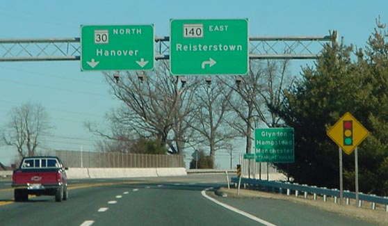
Taking Exit 9B, MD 795 intersects MD 140 (Westminster Pike). The towns of Hampstead and Manchester lie north along MD 30 while unincorporated Glyndon is just east of MD 30/795 along MD 128 (Butler Road). Photo by Tim Reichard (02/24/02).

Curving westward, I-795 concludes at a wye interchange with MD 140 (Westminster Pike) alongside Reisterstown Regional Park. 06/20/12

MD 140 (Westminster Pike) transitions to a rural highway leading northwest from Reistertown. Ensuing signals operate at Nob Hill Park Drive and Gores Mill Road south. 06/20/12
![]() East at
East at ![]()

Eastbound MD 140 splits with Interstate 795 south just beyond Mitchell Drive to Reisterstown Regional Park. 06/20/12

MD 140 (Westminster Pike) continues east from the wye with I-795 into Historic Reisterstown. I-795 parallels the state route to the west en route to Owings Mills and Pikesville. 06/20/12

Previous guide signs and trailblazers posted along MD 140 (Westminster Pike) east at I-795. 06/17/00
South End  – Pikesville, Maryland
![]() South at
South at ![]()

I-795 and the Metro SubwayLink weave southward along side Gwynns Falls to the exchange with Interstate 695. Advance signs partition motorists for I-95 leading away from the Baltimore area. 06/20/12
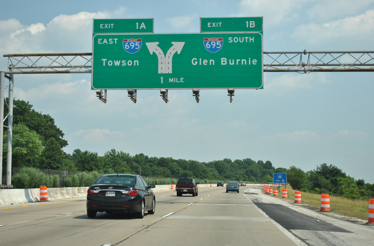
Exit 1B departs from the outside lanes of I-795 south for I-695 south to Catonsville, Arbutus, Halethorpe and Glen Burnie. 06/20/12

Two lanes navigate along a flyover (Exit 1A) for I-695 east to Pikesville, Towson, Parkville and Overlea. 06/20/12

Interstate 795 south concludes at a directional T interchange with the Baltimore Beltway. The MTA Old Court station lies within the exchange. 06/20/12
![]() North at
North at ![]()

Interstate 695 heads north between the Lochearn and Randallstown communities to Exit 19 with the Northwest Expressway. 06/20/12

I-695 north expands to five lanes leading into the directional T interchange (Exit 19) with Interstate 795. I-795 spurs northwest between Randallstown and parallel MD 140 to Owings Mills. 06/20/12

Exit 19 leaves the Baltimore Beltway for I-795 north to Reisterstown. The Northwest Expressway replaced MD 140 (old U.S. 140) along part of the route to Westminster. 06/20/12
![]() West at
West at ![]()

Curving southwest through Pikesville, Interstate 695 meets MD 140 (Reistertown Road) at a SPUI (Exit 20) one mile ahead of I-795. 06/20/12

The forthcoming exchange joining Interstate 695 west with Interstate 795 dates from 1983-84. 06/20/12

A CSX Railroad line spans I-695 at the departure of Exit 19 for the Northwest Expressway. 06/20/12
Sources:
- Northwest Expressway (I-795). DCRoads.net.
Page updated December 14, 2020.