Interstate 675 Ohio

Overview
Connecting I-75 in Miami Township with I-70 in Mad River Township, Interstate 675 forms an eastern bypass of Dayton to the south and east, providing part of a regional route south to Cincinnati and east to Springfield. The freeway loop also travels through the cities of Centerville, Kettering, Beavercreek and Fairborn and serves Wright-Patterson Air Force Base.
 History
The original proposed alignment for Interstate 675 called for it to loop back to I-75 in the vicinity of Northridge. It was later realigned to link with I-70 west of Springfield.
Interstate 675 was approved by the American Association of State Highway and Transportation Officials (AASHTO) on June 23, 1969. The freeway was completed by 1989.
Route Information
North End – Medway, OH
South End – Miamisburg, OH
Mileage – 26.97
Cities – Centerville, Kettering, Beavercreek, Dayton, Fairborn
- Junctions –

I-675 Annual Average Daily Traffic (AADT)
Source: 2017/18 AADT – ODOT Transportation Data Management System
North End  / Spangler Road – Medway, Ohio
![]() North at
North at ![]()
![]()

Exit 24 leaves Interstate 675 north for SR 444 to Holiday Valley and the village of Enon 1.25 miles south of I-70/SR 4. SR 4 overlaps with I-70 for six miles between freeway spurs to Wright-Patterson AFB and Springfield. Photo by Chris and Amber Lokken (05/10/08).

Exit 26 A for Interstate 70 and SR 4 to Springfield and Columbus departs beyond the Haddix Road overpass. Photo by Eric Stuve (07/29/17).

Interstate 675 concludes at a cloverleaf interchange (Exits 26 A/B) with I-70 and SR 4 southeast of Medway. Photo by Chris and Amber Lokken (05/10/08).

Interstate 70 travels 106 miles west to Indianapolis, Indiana by way of Vandalia, Richmond and Greenfield, Indiana. Spangler Road extends northwest as a local route into unincorporated Medway. Photo by Chris and Amber Lokken (05/10/08).
![]()
![]() East at
East at ![]()

SR 4 combines with Interstate 70 east ahead of the cloverleaf interchange (Exit 44) with I-675 south and Spangler Road north. Photo by Steve Hanudel (08/20/05).

One mile ahead of Exit 44 A for I-675 south to Wright Patterson Air Force Base, the city of Fairborn, and Wright State University. Photo by Chris and Amber Lokken (05/10/08).

Interstate 675 wraps around the east side of the Dayton area, leading to I-75 south toward Cincinnati from Miamisburg. Photo by Chris and Amber Lokken (05/10/08).

Exit 44 A leaves I-70/SR 4 east for Interstate 675 south. Exit 44 B follows onto Spangler Road (Township Road 335) north to Medway. Photo by Chris and Amber Lokken (05/10/08).
![]() South at
South at ![]()
![]()

Spangler Road crosses the Mad River and transitions into Interstate 675 south at the cloverleaf interchange (Exit 26) with I-70/SR 4. Photo by Chris and Amber Lokken (05/10/08).

The succeeding ramp connects Spangler Road and the beginning of I-675 south with Interstate 70 and SR 4 east to Springfield and Columbus. Photo by Chris and Amber Lokken (05/10/08).
South End – – Miamisburg, Ohio
![]() South at
South at ![]()

I-675 narrows from six to four lanes at the parclo interchange (Exit 2) with SR 725. The freeway converges with I-75 south of Dayton Mall in 1.5 miles. Photo by Steve Hanudel (08/20/05).

Three quarters of a mile out from the directional T interchange with Interstate 75. Photo by Chris and Amber Lokken (05/10/08).
The southbound mainline of I-675 defaults onto Interstate 75 south through Miamisburg, Springboro and Franklin. Photo by Chris and Amber Lokken (05/10/08).

A pair of end shields stand at the northbound ramp for I-75 to West Carrollton, Moraine and Dayton. Photo by Steve Hanudel (08/20/05).
![]() North at
North at ![]()

Interstate 75 straddles the Springboro city line ahead of Miamisburg and the split with I-675 at Exit 43. Photo by Chris and Amber Lokken (05/10/08).

Construction in 2009/10 added a diamond interchange with Austin Boulevard one mile south of the separation with Interstate 675. Photo by Chris and Amber Lokken (05/10/08).

Interstate 675 travels 17.2 miles north from I-75 to SR 844 (McClerron Memorial Skyway), a freeway spur north to Wright State University and Wright-Patterson Air Force Base. Photo by Eric Stuve (07/29/17).

A lane drop occurs at Exit 43 for Interstate 675 north to I-70 east for Columbus. Photo by Eric Stuve (07/29/17).

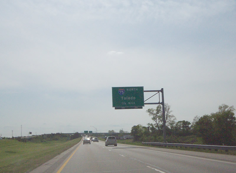
Interstate 675 branches northeast between Centerville and Kettering. I-75 continues north to Dayton and Toledo. Photo by Eric Stuve (07/29/17).
![]() South at
South at ![]()

Heading south through Miami Township, Interstate 75 meets SR 725 along a commercialized stretch west of Dayton Mall and north of I-675. Photo by Eric Stuve (05/14/17).
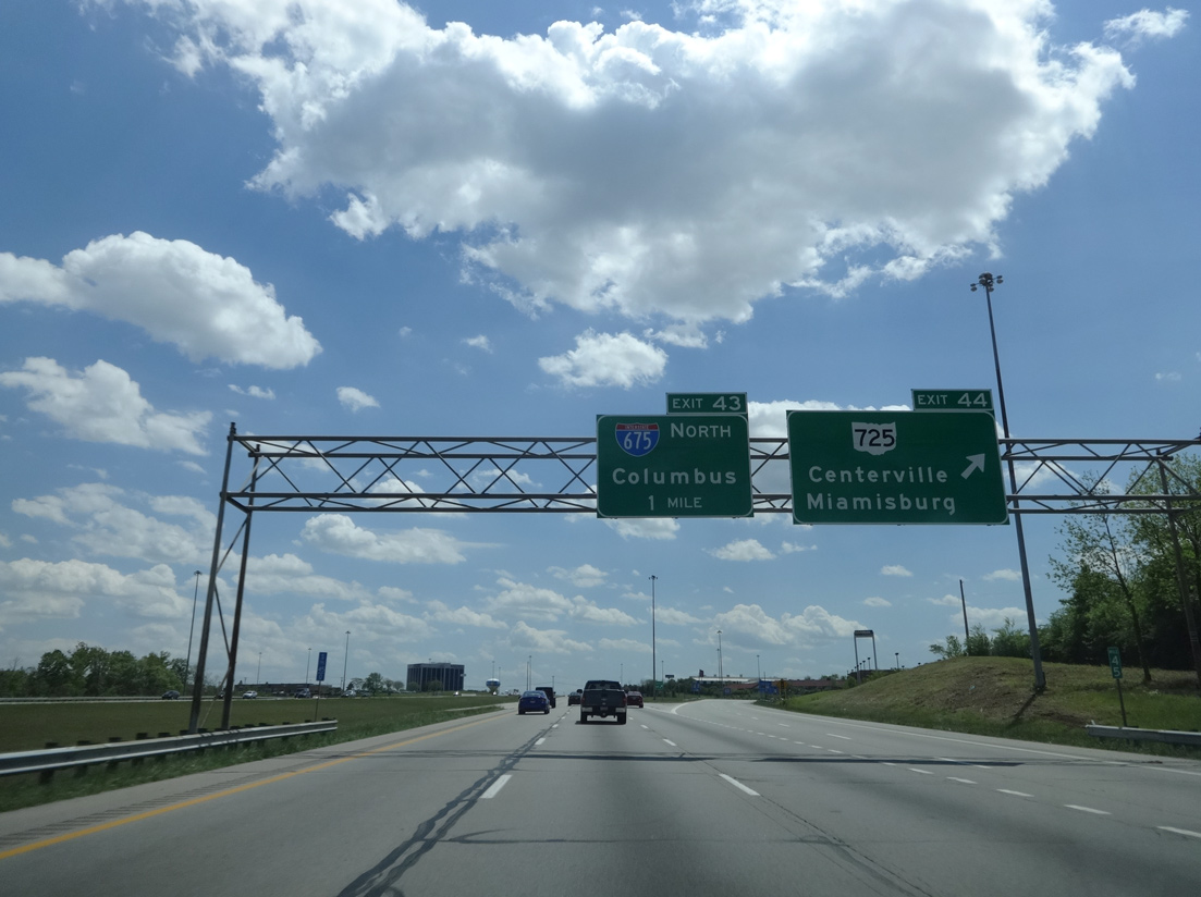
SR 725 travels east from Exit 44 to I-675 at Exit 2 en route to the city of Centerville and west across Miamisburg to SR 4 in Germantown. Photo by Eric Stuve (05/14/17).

Interstate 75 south enters the directional T interchange (Exit 43) with I-675 north just beyond the Lyons Road overpass. Photo by Eric Stuve (07/23/14).

Interstate 675 runs east from Exit 43 to Centerville before turning north into Beavercreek. Photo by Eric Stuve (05/14/17).
Page updated July 1, 2022.