Interstate 565 Alabama

Overview
Interstate 565 constitutes a freeway leading east from I-65 and U.S. 72 Alternate at the city of Decatur to Madison, Huntsville and U.S. 72 across Chapman Mountain. I-565 directly replaced portions of U.S. 72 Alternate and Alabama State Route 20. Completion of the freeway fueled growth in the Huntsville area in conjunction with research at NASA’s Marshall Space Flight Center and the Redstone Arsenal.
A directional T interchange was proposed along Interstate 565 around a half mile west of the Zierdt Road underpass for the Town Madison project. Located on the south side of I-565 at Zierdt Road, Town Madison was envisioned as a big box power center with 1.5 million square feet of retail and commercial space. Approved by the Alabama Department of Transportation (ALDOT) and the Federal Highway Administration (FHWA) on August 28, 2015, work was scheduled to begin in 2016 and run through June 2017.11 The interchange was previously proposed in 2007, but traffic numbers at the time did not support it.10
The eastbound exit from I-565 to Town Madison eventually opened to traffic on April 29, 2021 following months of dispute between ALDOT and the developers of Town Madison. The developer had not met outlined obligations regarding the westbound section of the exchange. Town Madison is a 500 acre plus mixed-use development where Toyota Field, home of Huntsville’s Minor League Baseball team, is located. Estimated to cost $28 million with funds from Town Madison, the flyover linking I-565 west from Town Madison Boulevard will take two years to complete.12
High Priority Corridor
Interstate 565 is part of High Priority Corridor 7: U.S. 72 and High Priority Corridor 11: ADHS Corridor V.
 History
19.2 miles of I-565 were added to the Interstate system in 1969 and approved by the American Association of State Highway Officials (AASHO) on June 23, 1969.5 Construction would take over two decades, with the route fully open by December 1991.6 Further work extended the freeway slightly east with the May 17, 2004 opening of the interchange at U.S. 72 (Lee Highway), Maysville Road and I-565 at Chapman Mountain (Exit 21).2
A westward extension of the limited access highway from I-65/565 to the U.S. 31 bridges over the Tennessee River was previously considered. The Fiscal Year 2005 Federal Transportation Department appropriations bill passed by Congress on November 20, 2004, included $3 million to begin efforts to extend Interstate 565 west to Decatur.3 Further funds were identified in the SAFETEA-LU legislation that was signed by President Bush in August 2005.
Alabama Department of Transportation (ALDOT) officials planned a three mile extension of Interstate 565 eastward over Chapman Mountain to a new split diamond interchange at Moores Mill and Shields Roads. Construction of the $21.5 million project was slated to start in 2007.1 However work was shelved and subsequently reevaluated.
A public meeting held December 15, 2011 outlined a $30 million interchange design eliminating the intersection at High Mountain Road. This change would have extended the limited access highway portion of U.S. 72 to Shields Road.7 Instead work through February 2016 expanded the existing at-grade alignment of U.S. 72 to six lanes and made improvements at the intersection with Moore Mill Road.8
$9.4 million in construction from December 2013 to April 10, 2015 added two ramps at Interstate 565 and County Line Road.9 These movements complimented the adjacent wye interchange with Madison Boulevard.
Route Information
East End – Huntsville, AL
West End – Decatur, AL
Mileage – 21.40
Cities – Decatur, Madison, Huntsville
- Junctions –

Source: December 31, 2021 Interstate Route Log and Finders List
I-565 Annual Average Daily Traffic (AADT)
Source: 2017 AADT – Alabama Traffic Data

Interstate 565 directly overlaid or replaced U.S. 72 Alternate between Decatur and Huntsville.

The North Huntsville bypass (SR 255) would have provided traffic relief to U.S. 72 across Chapman Mountain. Only the west leg of SR 255, between I-565 and SR 53, was constructed as a full freeway.
 Photo Guides
East End 
 – Huntsville, Alabama
![]()
![]() East at
East at ![]()

Leaving Oakwood Avenue, Interstate 565 continues another mile to a folded diamond interchange (Exit 21) with U.S. 72 (Lee Highway) west and Maysville Road south. 06/10/17

Climbing onto Chapman Mountain, Interstate 565 reaches the loop ramp (Exit 21) for U.S. 72 (Lee Highway) west to Sparkman Drive and U.S. 231/431 (Memorial Parkway). U.S. 72 east converges with the ending freeway ahead of Epworth Drive. 06/10/17

An end shield stands along U.S. 72 eastbound ahead of the service road to adjacent Epworth Drive and High Mountain Road. Photo by Jason Ilyes (05/09/04).
![]() West at
West at ![]()
![]()

U.S. 72 ascends over Chapman Mountain through Certain Gap ahead of the separation with Interstate 565 at Exit 21. 06/10/17

An at-grade intersection with High Mountain Road and Epworth Drive precedes the folded diamond interchange (Exit 21) with U.S. 72 west and Maysville Road. 06/10/17

The third lane added along U.S. 72 westbound over Chapman Mountain defaults onto the continuation of Lee Highway to Sparkman Drive in Huntsville. Beginning at Exit 21, U.S. 72 Alternate overlays all of I-565 west to I-65 and SR 20 at Decatur. 06/10/17
 East End Throwback
![]() East
East

I-565 eastbound originally concluded beyond Exit 20 with Oakwood Avenue. A series of end signs preceded the wye interchange along the elevated viaduct leaving Downtown Huntsville. The “end” and distances were eventually covered with overlays.4 Photo by Chris Patriarca (01/26/03).

Interstate 565 at Exit 20 to Oakwood Avenue. The Jackson County seat of Scottsboro is 41 miles to the east. Photo by Chris Patriarca (01/26/03).

Interstate 565 ended just beyond the viaduct ahead of an at-grade intersection with U.S. 72 (Lee Highway) west at Maysville Road. Photo by Chris Patriarca (01/26/03).
![]() West at
West at ![]()

Button copy overhead for U.S. 72 west posted at the turn lane for Lee Highway ahead of the signalized intersection with Maysville Road. U.S. 72 leads northwest from Huntsville and Madison to Athens. Photo by Chris Patriarca (01/26/03).

The previous westbound beginning of Interstate 565 was located at Oakwood Avenue and Andrew Jackson Way (Exit 20). Photo by Chris Patriarca (01/26/03).
West End – Decatur, Alabama
![]()
![]() West at
West at ![]()

Interstate 565 crosses Limestone Creek two miles ahead of I-65. The freeway spur concludes five miles to the east of the Decatur city center. Photo by David Prince (03/21/16).

All traffic to Interstate 65 departs from I-565 in unison at Exit 1. U.S. 72 ALT continues alongside SR 20 west from the freeway end to Downtown Decatur and Muscle Shoals. 06/10/17
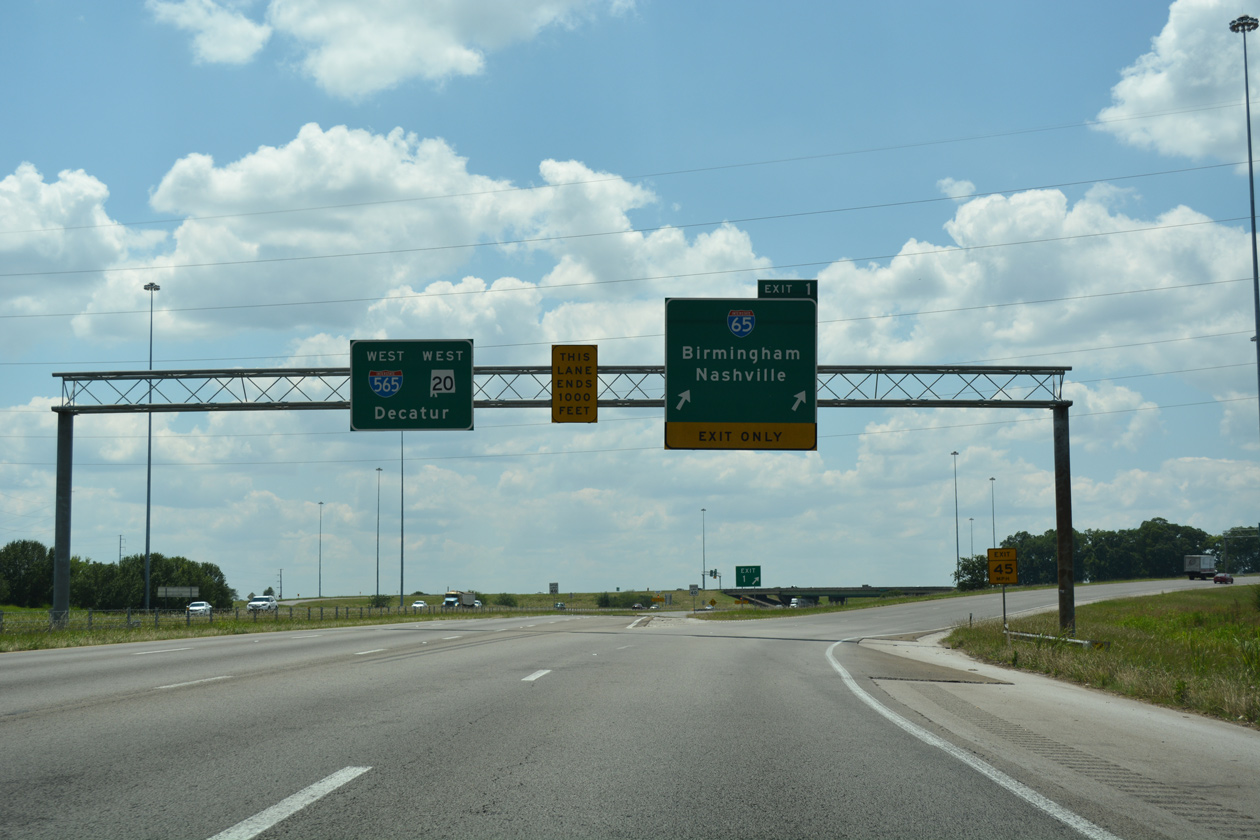
Traffic headed for Birmingham or Nashville leaves I-565/U.S. 72 ALT west at Exit 1. Although signage indicates that Interstate 565 continues onward, the designation concludes on the west side of the exchange. 06/10/17

A directional ramp links I-565 west with I-65 south, 74 miles from Birmingham. Nashville, Tennessee is 101 miles northward. 06/10/17

An end sign marks the western end of Interstate 565. U.S. 72 ALT/SR 20 proceed west 2.5 miles to converge with U.S. 31 south at a wye interchange ahead of Wheeler Lake. Photo by David Prince (03/21/16).
![]()
![]() East at
East at ![]()
![]()

Interstate 565 east begins as U.S. 72 ALT/SR 20 enter the directional cloverleaf interchange (Exit 1) with I-65. 06/10/17

Exit 1A leaves U.S. 72 ALT/SR 20 east for Interstate 65 south to Birmingham. I-65 crosses the Tennessee River on the seven miles to Priceville and the succeeding exit with SR 67. With all references to the overlap along I-565 removed beyond I-65, SR 20 concludes here. 06/10/17

Exit 1 B loops from I-565/U.S. 72 ALT-SR 20 east onto Interstate 65 north. I-65 travels 26 miles to Ardmore and the Tennessee state line through Athens. 06/10/17
![]() North at
North at ![]()
![]()
![]()

Interstate 65 traverses Wheeler National Wildlife Refuge beyond the Tennessee River and Limestone County line. I-565, U.S. 72 Alternate and SR 20 lie one mile to the north. 06/10/17

Interstate 565 east serves Redstone Arsenal and the NASA Marshall Space Flight Center in addition to Huntsville. Various technological weapons for the U.S. Military are developed at the arsenal. 06/10/17

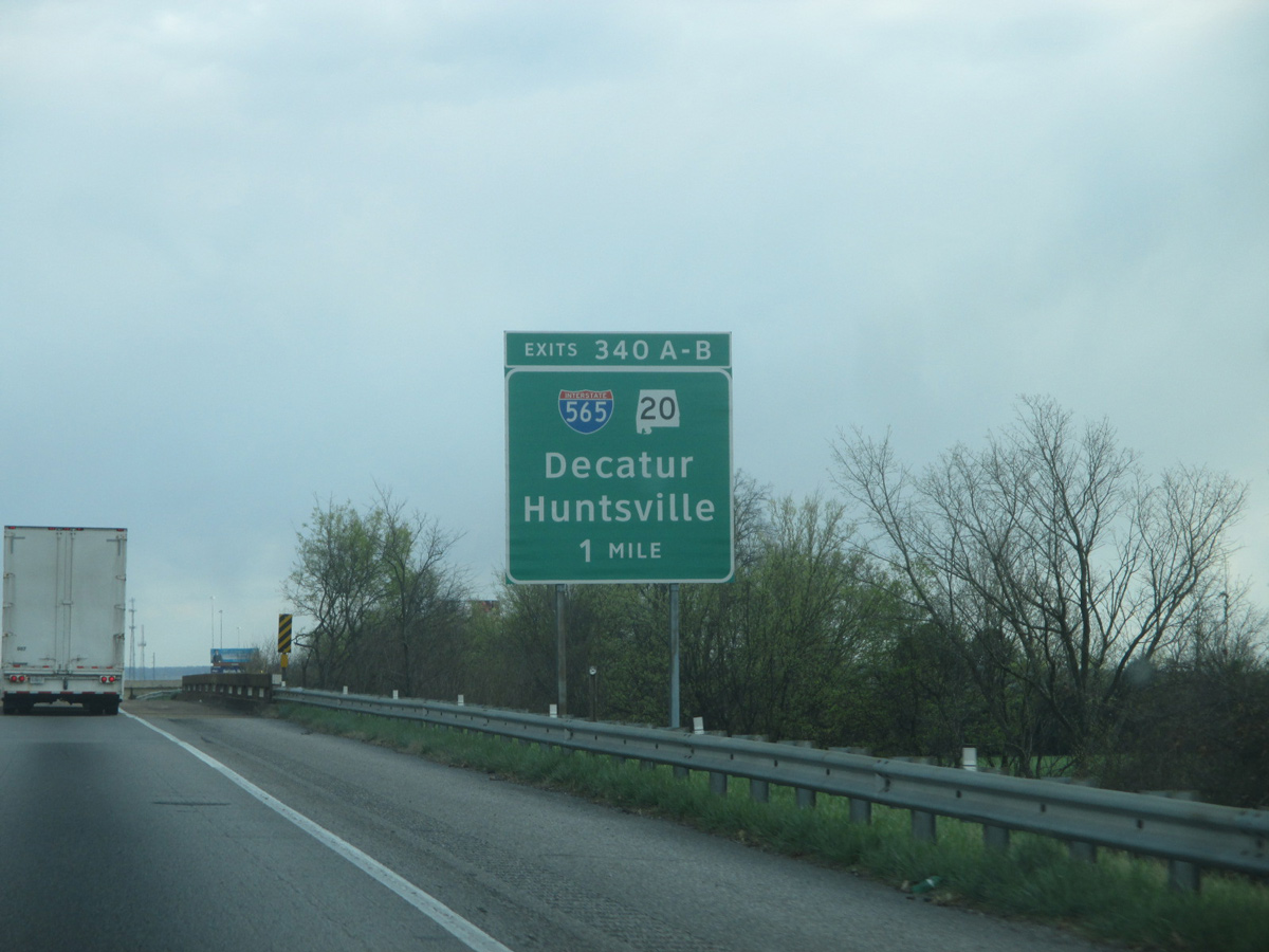
A collector distributor separates from northbound I-65 for I-565 east to Huntsville and U.S. 72 Alternate/SR 20 west to Decatur. 06/10/17

A two lane ramp departs from the c/d roadway at Exit 340 A for Interstate 565 east to Madison and Huntsville. 06/10/17
![]() South at
South at ![]()
![]()
![]()

Interstate 65 parallels Piney Creek southward from Tanner to the exchange with I-565 east, U.S. 72 ALT and SR 20 west. Photo by David Prince (03/20/16).
I-65 spans a Norfolk Southern Railroad line one mile north of the directional cloverleaf interchange (Exit 340) with I-565/U.S. 72 ALT. Photo by David Prince (03/20/16).

Although the first off-ramp from the north, U.S. 72 Alternate/SR 20 west is signed as Exit 34 0A instead of 340 B. The Morgan County seat of Decatur is a five minute drive to the southwest. Photo by David Prince (03/20/16).

A loop ramp (Exit 340 B) joins I-65 south with I-565/U.S. 72 Alternate east to Mooresville, Madison, Huntsville International Airport (HSV) and Huntsville. The city limits of the “Rocket City” extend this far west, 19 miles away from Downtown. Photo by David Prince (03/20/16).
Throwback – North at


All guide signs for Exit 340 were replaced with Clearview font based assemblies by 2015. 04/04/13

A greenout for “East” covers “North”, as the freeway was initially posted with north/south directions to benefit motorists to and from Birmingham.6 04/04/13
Sources:
- “I-565 could go beyond Shields Road.” Huntsville Times (AL), August 15, 2004.
- Lamb, Daniel. “I-565 Exit 21 Now Open.” Online posting, Yahoo Groups – Southeast Roads and Transport, May 17, 2004.
- “Appropriations bill includes $3 million for I-565 extension: Money to be used to stretch road west toward Decatur”
http://www.al.com/news/huntsvilletimes/index.ssf?/base/news/1101204900271040.xmlin Huntsville Times, November 23, 2004. - Philip R. “I-269 broken link / I-565 info and question / I-69 MS info.” Personal Email, 1/18/08.
- “Confusing signs to be changed.” Gadsden Times (AL), December 18, 1991.
- “The Interstate System.” Tuscaloosa News (AL), September 21, 1969.
- “Change of plans for U.S. 72 project at Moores Mill, Shields roads.” The Huntsville Times (AL), December 13, 2011.
- “Driving You Crazy: Hwy. 72 & Chapman Mountain.” WHNT (Huntsville, AL), October 21, 2015.
- “County Line Road, I-565 interchange to open Friday.” Decatur Daily (AL), April 9, 2015.
- “New I-565 interchange is big win for Town Madison shopping complex.” The Huntsville Times (AL), September 4, 2015.
- “New I-565 interchange approved for Madison.” WHNT (Huntsville, AL), August 28, 2015.
- “As Town Madison celebrates I-565 ramp opening, interchange looks toward conclusion.” AL.com, April 29, 2021.
Page updated June 2, 2022.