Interstate 475 Ohio

Overview
Interstate 475 is a bypass and commuter route in the Toledo metropolitan area. Looping west from I-75 at Perrysburg, the freeway crosses the Maumee River into the city of Maumee. Proceeding north. I-475 heads through Holland along the west side of Toledo to connect directly with the U.S. 23 freeway to Ann Arbor, Michigan near Sylvania. The remainder of I-475 travels east back to I-75 near Downtown Toledo.
 History
Interstate 475 first opened as a section of relocated U.S. 23 between West Central Avenue (U.S. 20) and Monroe Street (Ohio 51) in Sylvania. A ribbon cutting ceremony was held on November 2, 1962 for the roadway that cost $5 million. Traffic began use on it a few days later once sign and guard rail installation was completed. The highway tied into a preexisting section of the expressway leading U.S. 23 north into Michigan.1 That stretch of U.S. 23 north to Dundee opened to traffic on December 11, 1959 at a cost of $8.4 million.2
The two spans carrying Interstate 475 across the Maumee River were constructed from 1962 to 1964 at a cost of $1.4 million. The bridges were unique in that they curved on both the vertical and horizontal planes, with the vertical element banked at 0.025 feet per lineal foot. Separated by 84 feet, the seven span bridges are supported by 25 foot high piers measuring 1,481 feet in length.3 The bridges opened along with I-475 southeast from U.S. 24 (Anthony Wayne Trail) to U.S. 25 (Dixie highway), south of Perrysburg, in Fall 1966. The 2.8 mile segment extending east from the bridges to U.S. 25 was built at a cost of $3.1 million and completed in 1964. The $2.6 million extension northward to the interchange with U.S. 24 was under construction from October 10, 1964 to November 30, 1966.4
The freeway north from U.S. 24 to U.S. 20 (West Central Avenue) was dedicated on November 21, 1968. The 8.3 mile long stretch of I-475 cost $12.5 million.5 The 2.1 mile section of I-475 between Corey Road (Exit 15) and Secor Road (Exit 17) was constructed from Spring 1968 to November 1969 for $6.7 million.6 This segment tied into the final link of I-475, the mile long freeway between Secor Road and Douglas Road. Bids for this portion were received on June 17, 1969 with completion anticipated for November 30, 1970.7 The Northwest Expressway was completed on December 15, 1970. The northeast end of I-475 defaulted traffic onto I-75 southbound, as the segment of I-75 north was still under construction.8
Route Information
North End – Toledo, OH
South End – Perrysburg, OH
Mileage – 20.61
Cities – Perrysburg, Maumee, Sylvania, Toledo
- Junctions –

I-280 Annual Average Daily Traffic (AADT)
Source: 2017/18 AADT – ODOT Transportation Data Management System

Cardinal directions on I-475 change from east/west to north/south once the freeway turns southward alongside U.S. 23 at Sylvania. 09/02/05
Under a 10 year $5 billion transportation improvement plan announced August 6, 2003 by Governor Bob Taft, Interstate 475 was expanded from four to six lanes between Corey Road (Exit 15) southward to the Maumee River crossing. Additionally the northern exchange between I-75/475 was reconstructed and improved. A three year, six cent hike to the state’s motor fuels tax covered the costs of these projects.9
 Photo Guides
North End  – Toledo, Ohio
![]() North at
North at ![]()

Advancing beyond Downtown Toledo, I-75 parallels SR 51 (Monroe Street) northwest to the exchange with Interstate 475 west. Photo by Eric Stuve (03/08/19).
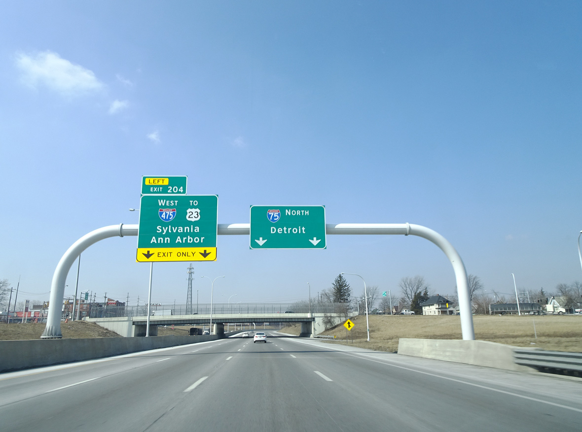
U.S. 24 (Detroit Avenue) connects with I-75 a half mile south of Left Exit 204 for Interstate 475 west. Photo by Eric Stuve (03/08/19).

Interstate 475 leads 6.6 miles west from Exit 204 to combine with U.S. 23 at Sylvania, U.S. 23 enters Ohio south from Ann Arbor, Michigan. Photo by Eric Stuve (03/08/19).

A directional T interchange connects I-75 north with Interstate 475 west at Left Exit 204. Photo by Eric Stuve (03/08/19).
 North End Throwback
![]() North at
North at ![]()

The original button copy signs at I-475 west were replaced with a diagrammatic sign between 2002 and 2005. Photo by Don Hargraves (08/02).
![]() South at
South at ![]()

Previously a left side ramp at Exit 205 A for Jeep and Willys Parkways preceded the north end of I-475 from Interstate 75 southbound. Photo by Don Hargraves (08/02).

I-75 curves southwest adjacent to the Ottawa River and Willys Park to the east end of Interstate 475 at Exit 204. Photo by Don Hargraves (08/02).

A lane drop occurred at the upcoming exchange (Exit 204) with Interstate 475 west to U.S. 23. Photo by Don Hargraves (08/02).
South End – Perrysburg, Ohio
![]()
![]() South at
South at ![]()

I-475/U.S. 23 arc southeast from the Maumee River to meet SR 25 (Dixie Highway) just prior to I-75 in Perrysburg. 09/02/05

The exchange at Exit 2 with SR 25 (Dixie Highway) was converted to a DDI. SR 25 is the old alignment of U.S. 25 between Toledo and Cygnet. While there are other state maintained sections of Old U.S. 25, most of the route in Ohio is locally maintained. 09/02/05
U.S. 23 south combines with I-75 north to Exit 193 / U.S. 20 in Perrysburg. 09/02/05

A single lane ramp connects I-475 with Interstate 75 south to Findlay, Lima, Dayton and Cincinnati. 09/02/05
![]() North at
North at ![]()
![]()

Two miles from the separation with I-475 on Interstate 75 north. Photo by Eric Stuve (07/09/17).

I-75 enters the city of Perrysburg just ahead of Left Exit 192 for I-475/U.S. 23 north to Maumee, Holland and west Toledo. Photo by Eric Stuve (07/09/17).

West from I-75 and the adjacent DDI with SR 25 at Perrysburg, Interstate 475 combines with U.S. 23 across the Maumee River to Sylvania. Photo by Eric Stuve (07/09/17).

U.S. 23 north overlaps with I-75 from the three wye interchange (Exit 192) with I-475 to the ensuing exit, where it joins U.S. 20 to Stony Ridge and Lemoyne. Photo by Eric Stuve (07/09/17).
![]() South at
South at ![]()
![]()

I-75 proceeds southwest from the exchanges with the Ohio Turnpike (I-80/90) and SR 795 (Avenue Road) at Rossford 2.5 miles to the south end of Interstate 475. Photo by Eric Stuve (07/23/14).

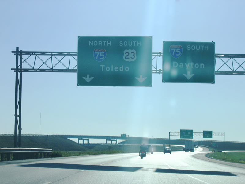
U.S. 23 north combines with I-75 south from U.S. 20 (Fremont Pike) just ahead of Exit 192 for Interstate 475. Photo by Eric Stuve (07/23/14).

U.S. 23 north joins I-475 west from Perrysburg to Maumee. The two routes overlap for 13.6 miles to Sylvania. Photo by Eric Stuve (07/23/14).

U.S. 23 continues north from I-475 and Toledo to Ann Arbor, Michigan. I-75 heads south to Bowling Green, Findlay and Lima. Photo by Eric Stuve (07/23/14).
South End Throwback
![]() North at
North at ![]()
![]()

Six lane expansion along I-75 south of I-475/U.S. 23 included sign replacements for Exit 192. Photo by Steve Hanudel (07/04/06).

Construction widening Interstate 75 south of Perrysburg was underway from 2014 to 2017. Photo by Steve Hanudel (07/04/06).

A diagrammatic sign replaced overheads for the I-75/475 split at the Perrysburg corporate limits by 2006. Photo by Dan Garnell (01/22/03).

The diagrammatic overhead by the Roachton Road overpass for I-475 was removed in 2015 during construction. Photo by Steve Hanudel (07/04/06).

Guide signs for I-75 at Exit 192 omit the overlap with U.S. 23 northbound. Photo by Dan Garnell (01/22/03).

The third lane added along I-75 north into Perrysburg by 2017 drops at Exit 192 / Interstate 475. Photo by Steve Hanudel (07/04/06).
Sources:
- “Central-To-Monroe Leg Of New U.S. 23 Opened In Full-Dress Ceremony—Then Closed To Traffic.” Toledo Blade (OH), November 3, 1962.
- “Two New Ohio-Michigan Links Climax Decade Of Highway Plans.” Toledo Blade (OH), December 27, 1959.
- “2 Curved Bridges Designed To Carry Interstate 475 Over Maumee River.” Toledo Blade (OH), October 29, 1962.
- “$6.6 Million I-475 Bypass Opening Near.” Toledo Blade (OH), October 19, 1966.
- “Two Most Exciting Years Forecast By Rhodes At I-475 Link Dedication.” Toledo Blade (OH), November 21, 1968.
- “Section Of I-475 To Be Done Soon, But It Won’t Be Open Until Summer.” Toledo Blade (OH), September 12, 1969.
- “Bids Due June 17 On I-475 Stretch.” Toledo Blade (OH), May 30, 1969.
- “Expressway’s Opening To Bring Some Relief, Some Headaches.” Toledo Blade (OH), December 4, 1970.
- “Taft plan would widen I-75, I-475.” The Toledo Blade (OH), August 7, 2003.
Page updated July 3, 2022.