Interstate 469 Indiana

Overview
Interstate 469 encircles Indiana’s second largest city from I-69 south of Fort Wayne to I-69 north of the city. The bypass basically serves local traffic by providing a high speed option to the eastern reaches of the Fort Wayne metropolitan area. Interstate 69 runs along the west side of the city.
Maintaining two lanes in each direction along a 31 mile long course, Interstate 469 was constructed with a concrete median and roadways. The freeway navigates through narrow rights of way, giving a very urban feel despite traveling mostly through rural areas of the greater Fort Wayne area.
Similar to other urban centers across Indiana, the Fort Wayne bypass carries other signed routes away from the city. U.S. 24 accompanies I-469 to the north from I-69 at Exit 31 to Exit 21. U.S. 30 also overlaps with I-469 along this stretch, continuing south to Exit 19. U.S. 33 runs alongside I-469 from I-69 at Exit 0 to Exit 11.
Through Fort Wayne, only U.S. 27 remains routed through the city. Formerly extending north to Lansing, Michigan, it ends at I-69 / Exit 111 in Fort Wayne. Indiana State Roads 1 and 37 both are marked as ending or beginning where they meet the I-69/469 belt. They are not cosigned with either freeway.
Route Information
North End – Fort Wayne, IN
South End – Fort Wayne, IN
Mileage – 30.83
Cities – Fort Wayne, New Haven
- Junctions –

Source: December 31, 2021 Interstate Route Log and Finders List
I-469 Annual Average Daily Traffic (AADT)
 History
The 1970 Fort Wayne/Allen County Transportation Plan outlined an east to west freeway across the city of Fort Wayne. With cost estimates at $110 million, funding was not allocated and the freeway was never constructed. However with increases in heavy truck and through traffic in Fort Wayne, leaders sought relief for U.S. 24 and U.S. 30. The southern half of Interstate 469 was subsequently planned as a bypass of U.S. 24, which used to run through Downtown. The northern arc of I-469 was designed to bypass U.S. 30, which previously followed Coliseum Boulevard (SR 930). As of 1978, only the southern half of the Fort Wayne bypass was envisioned. This plan was amended by 1981 to incorporate a complete bypass from I-69 on either end.
Groundbreaking for the $207 million Fort Wayne bypass took place on July 13, 1984. The first portion of I-469 built was the southernmost segment between Interstate 69 and Indianapolis Road. It was finished in September 1988. Additional segments were built in a counter-clockwise direction, between January, August and November 1990 and October 1992. The final section was completed on October 23, 1995, reconnecting I-469 with I-69 from SR 37 west.1
The American Association of State Highway and Transportation Officials (AASHTO) approved the numbering of Interstate 469 from an application by the state of Indiana on June 7, 1989. Prior to completion of the entire beltway, succeeding segments of the Fort Wayne belt line opened to traffic were signed as State Road 469. The Federal Highway Administration (FHWA) approved redesignating the freeway as Interstate 469 following its completion in 1995.1
The usefulness of Interstate 469 as a bypass was questioned in a 2008 article printed in the The Fort Wayne Journal Gazette:2
But while I-469 is called the bypass, it likely won’t ever serve as one for people traveling north or south through the city. While signs direct I-69 through-traffic to I-469, most drivers in the know avoid the route. Taking I-469 would add 12 miles to a trip around Fort Wayne compared with taking I-69.
Some in the business community suggested removing signs that refer to Interstate 469 as a viable bypass of Fort Wayne. However, trucks commonly use the bypass to avoid urban traffic and I-469 is also useful for regional travelers, especially those along the U.S. 24 (Hoosier Heartland Corridor) and U.S. 30 corridors.
 Photo Guides
North End  – Fort Wayne, Indiana
![]() North
North ![]()
![]() West at
West at ![]()

The last mainline interchange (Exit 29) for I-469 west connects with Maplecrest Road at northern reaches of Fort Wayne. Photo by Thomas Decker (02/06/12).

U.S. 30 overlaps with I-469 west from Exit 19 to I-69 south through Fort Wayne. U.S. 30 overlaps with I-69 six miles to U.S. 33 north. 11/06/11

Signs for Interstate 69 retained U.S. 27 shields from when the two combined northward to the Michigan state line. U.S. 27 was formally truncated to Exit 311 in 2002. 11/06/11

Exit 31A departs from I-469/U.S. 24-30 west next for Interstate 69 north to Angola and Lansing, Michigan. 11/06/11

Lansing, Michigan is a 120 mile long drive to the north from I-469 in Fort Wayne. U.S. 24 west joins I-69 south to Jefferson Boulevard near Ellisville. 11/06/11

The westbound mainline for I-469 defaults onto Exit 31B for I-69 south to Indianapolis. Exit 31C branches northward to Auburn Road and nearby Dupont Hospital. 11/06/11
![]() South at
South at ![]()
![]()
![]()

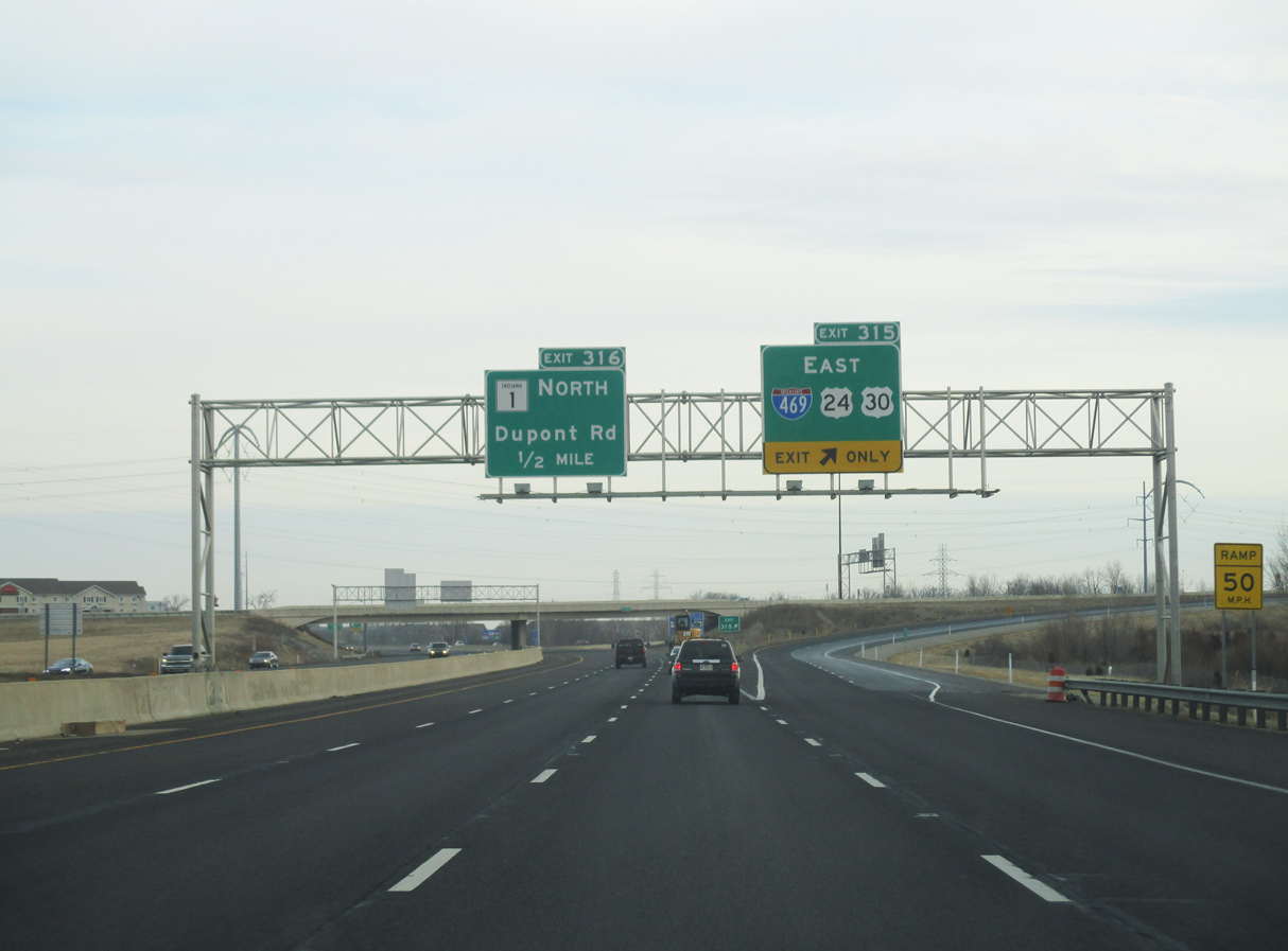
A diverging diamond interchange joins I-69 with SR 1 (Dupont Road), one mile north of Exit 315 for Interstate 469 and U.S. 24/30. Photo by Thomas Decker (03/07/16).

U.S. 30 combines with I-469 east for 12 miles to New Haven, where it resumes its eastward course to Van Wert, Ohio. U.S. 24 was relocated from the south half of I-469 to the northern half following completion of the Hoosier Heartland Expressway. Photo by Thomas Decker (03/07/16).

Exit 315 leaves I-69 south for I-469 and U.S. 24/30 east. I-469 travels across the suburban north side of Fort Wayne to Exit 25. U.S. 24 branches east from New Haven to Ohio. Photo by Thomas Decker (03/07/16).
![]() North
North ![]()
![]() East at
East at ![]()

One mile south of Exit 315 for Interstate 469 east on I-69/U.S. 24-30 northbound. Photo by Thomas Decker (03/07/16).

U.S. 30 overlaps with I-69 north six miles to I-469/U.S. 24 east at the forthcoming trumpet interchange (Exit 315). Photo by Thomas Decker (03/07/16).

Interstate 69 north expands to four lanes ahead of Exit 315 for I-469 and U.S. 24/30 east to New Haven. Photo by Thomas Decker (03/07/16).
Interstate 469 passes through the northern suburbs of Fort Wayne to SR 37 near Thurman. Succeeding exits along I-69 north connect with SR 1 and Union Chapel Road. Photo by Thomas Decker (03/07/16).
 North End Throwback
![]() North
North ![]() East at
East at ![]()

Leading toward I-469 east (old Exit 115) on Interstate 69 north and U.S. 30 east with just four overall lanes. Photo by Brian Dowd (12/02).

Northbound I-69 previously expanded to three lanes ahead of I-469 at Exit 115. Photo by Brian Dowd (12/02).
![]() South at
South at ![]()
![]()

All signs for Interstate 469 along I-69 southbound dating from the 1992 opening of the freeway were replaced when the freeway was widened to six lanes. Photo by Brian Dowd (12/02).

The entrance ramp from SR 1 (Dupont Road) south forms an auxiliary lane to I-469/U.S. 30 east. This overhead was eventually replaced and the trailblazer for U.S. 24 removed. Photo by Brian Dowd (12/02).

Several pull through signs along I-69 through Fort Wayne only displayed the overlapped U.S. Highways. U.S. 27 remained posted on this assembly as well. Photo by Brian Dowd (12/02).
South End – southwest of Fort Wayne, Indiana
![]() West
West ![]() North at
North at ![]()

Interstate 469 and U.S. 33 meet the eastern section of Lafayette Center Road at Exit 1. Construction of I-469 displaced a portion of the road west to I-69 (Exit 0). 11/06/11

The entrance ramp from Lafayette Center Road adds an auxiliary lane west to Exit 0B for I-69/U.S. 33 north. U.S. 33 accompanies I-69, 15 miles northeast to U.S. 30 west at Fort Wayne. 11/06/11

U.S. 24 previously combined with I-69 north from I-469 west five miles to Jefferson Boulevard. Approved by AASHTO on May 19, 2012, U.S. 24 was realigned around the north side of Fort Wayne from New Haven. 11/06/11

Exit 0A loops onto I-69 south from I-469 at the transition to Lafayette Center Road. Indianapolis lies 96 miles to the southwest. Photo by Brian Dowd (12/02).
Lafayette Center Road – East at ![]()
![]()
![]()

Lafayette Center Road leads east 0.75 miles from Fogwell Parkway to the exchange with Interstate 69, I-469 east and U.S. 33. Photo by Brian Dowd (12/02).

A traffic light for the General Motors Fort Waybe Assembly Plant precedes the directional cloverleaf interchange joining Lafayette Center Road with I-69/469. Photo by Brian Dowd (12/02).

Interstate 469 begins from Lafayette Center Road. U.S. 24 formerly dog legged southwest along I-69 to I-469 east to complete the bypass from Roanoke Station to New Haven. This I-469 overhead is the only sign in the area that gives the route a control city. Photo by Thomas Decker (09/19/09).

U.S. 33 combines with I-69 north to U.S. 30 in Fort Wayne. Interstate 69 continues north to Lansing and Flint, Michigan and south to Muncie, Anderson and Indianapolis. Photo by Brian Dowd (12/02).
![]() North at
North at ![]()
![]()

Interstate 69 concludes a 9.7 mile exit less stretch north from the town of Markle at upcoming Exit 296 with I-469 east, U.S. 33 south and Lafayette Center Road. Photo by Thomas Decker (03/07/16).

Trailblazers direct motorists along Interstate 469 east for U.S. 24 (Hoosier Heartland Expressway) east toward Toledo, Ohio and U.S. 30 at New Haven. Photo by Thomas Decker (03/07/16).

Exit 296A leaves I-69 north for Interstate 469 around the east side of Fort Wayne. U.S. 33 overlaps with I-469 to U.S. 27, which it combines with southeast to Decatur. Photo by Thomas Decker (03/07/16).
![]()
![]() South at
South at ![]()

One mile ahead of the directional cloverleaf interchange (Exit 296) with Lafayette Center Road west to the adjacent General Motors Fort Wayne Assembly Plant and the split of U.S. 33 south onto Interstate 469 east. Photo by Thomas Decker (03/07/16).

One mile ahead of the directional cloverleaf interchange (Exit 296) with Lafayette Center Road west to the adjacent General Motors Fort Wayne Assembly Plant and the split of U.S. 33 south onto Interstate 469 east. Photo by Thomas Decker (03/07/16).

Exit 296B separates from I-69 south with two lanes for Lafayette Center Road west to Roanoke and U.S. 24. Exit 296A follows in a half mile for Interstate 469 east to New Haven. Photo by Thomas Decker (03/07/16).

Traffic merges onto Interstate 69 south from I-469 west just ahead of Exit 296A. 11/06/11

Interstate 469 east / U.S. 33 south travel south of Fort Wayne International Airport (FWA) over the next six miles. 11/06/11
South End Throwback

The south end of Interstate 469 was formerly Exit 96A. Photo by Brian Dowd (12/02).

U.S. 24 overlapped with I-69 south to I-469 east until 2012. U.S. 24 varies between controlled access expressway and freeway between New Haven and I-475 at Maumee, Ohio. Photo by Brian Dowd (12/02).

Guide signs for Exit 296 were replaced following the relocation of U.S. 24 from the southern half of I-469 to the northern half. Photo by Brian Dowd (12/02).
Sources:
- “Ribbon-Cutting Opens I-469 Bayh Says $207 Million Road will Produce Jobs, Economic Security.” Journal Gazette, The (Fort Wayne, IN). October 24, 1995.
- “Bypassing THE BYPASS: After 20 years, Interstate 469 remains a lightly traveled loop.” The Fort Wayne Journal Gazette (IN), July 20, 2008.
Page updated July 21, 2021.