Interstate 295 Virginia

Overview
Interstate 295 constitutes a regional bypass route for I-64 around the north side of Richmond and I-95 east of Petersburg and Richmond. With six to eight lanes, the northern arc of I-295 serves a number of suburban communities including Glen Allen and Mechanicsville. The eastern leg connects with U.S. 60 and Virginia Route 895 (Pocahontas Parkway) west to Richmond International Airport (RIC).
The Varina-Enon Bridge spans the James River along I-295 at the Chesterfield / Henrico County line. Costing $35.6 million to build,1 the cable-stayed bridge is similar to the William Roth Bridge (Delaware State Route 1) over the Chesapeake and Delaware Canal and the Sunshine Skyway Bridge (Interstate 275) over Tampa Bay in Florida. South across the Appomattox River, I-295 travels between the independent city of Hopewell and Fort Gregg-Adams. The freeway concludes in a rural area by Second Swamp south of Petersburg.

Interstate 64 eastbound at the flyover for I-295 east. Costing $49.1 million, the high speed ramp was completed in May 2009. Photo by Will Weaver (06/28/09).
 History
The Interstate 295 corridor was originally envisioned as a full beltway encircling Richmond. The design was later incorporated into a proposed easterly realignment of I-95 off the congested Richmond-Peterburg Turnpike. Plans changed with the announcement that tolls on the Turnpike would be lifted in 1992. The American Association of State Highway and Transportation Officials (AASHTO) formally endorsed the establishment of Interstate 295 south to Peterburg on June 9, 1986.
The northern portion of Interstate 295 opened to traffic in 1981 at a cost of $60 million, with the federal government funding 90% of the construction.2 Work on the initial stretch of freeway commenced in May 1976 near Mechanicsville.3 Construction of the $37.7 million segment between U.S. 60 and SR 5, east of Richmond, began in July of 1984 and was completed on October 7, 1988.4
The succeeding portion of I-295 built included the Varina-Enon Bridge and a 6.8 mile section between SR 10 and SR 5. Started in March 1985, delays in road work followed a construction flaw where the Henrico County end of the Varina-Enon Bridge was four inches too low and needed adjustments. That pushed completion of the the $75 million project back from an anticipated Fall 1989 completion date. The span finally opened to traffic on July 19, 1990.1
Interstate 295 was extended 5.6 miles southward from SR 10 to SR 36 when a $57.7 million project was completed on January 21, 1992.5 The final 9.8 mile long section was scheduled to open on June 3, but officials from Petersburg successfully lobbied to delay it while tolls were still collected along Interstate 95 in the city. I-295 finally opened between Hopewell and I-95 in Prince Georges County on June 25, 1992. Tolls along the Richmond-Petersburg Turnpike were discontinued on July 1, 1992.6

Looking east from the Pouncey Tract Road overpass at the flyover connecting I-64 east with Interstate 295 south at Short Pump. Photo by Will Weaver (01/13/09).
Route Information
North End – Short Pump, VA
South End – Petersburg, VA
Mileage – 52.56
Cities – Petersburg, Hopewell, Richmond
- Junctions –

Source: December 31, 2021 Interstate Route Log and Finders List
I-295 Annual Average Daily Traffic (AADT)
Source: 2016 VDOT Traffic Volume

Interstate 295 proposed as a 270 degree beltway around Richmond – 1971 Virginia Official State Map. Pocahontas Parkway (SR 895) was eventually constructed in place of the southeast leg of I-295 here.

A flyover for Interstate 64 east from the southbound mainline of I-295 was added at this exchange in June 2001.

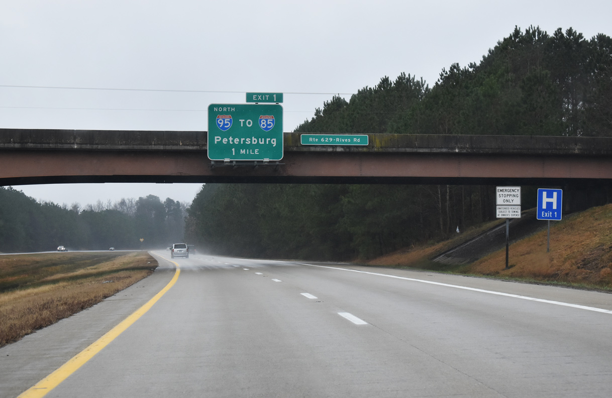
These overheads at the SR 629 (Rives Road) overpass referenced the former lane drop for I-95 south at the merge with Interstate 295. 08/26/96
 Photo Guides
North End  – Short Pump, Virginia
![]() North at
North at ![]()

Interstate 295 arcs southwest 1.5 miles from the cloverleaf interchange (Exit 51) with Nuckols Road near Wyndham to conclude at I-64. 12/30/20

A pair of end signs stand along Interstate 295 one mile ahead of the trumpet interchange (Exit 53) with I-64. 12/30/20
Interstate 295 runs between several subdivisions in the unincorporated area of Innsbrook, Short Pump and Wyndham to I-64 at Exit 53. 12/30/20

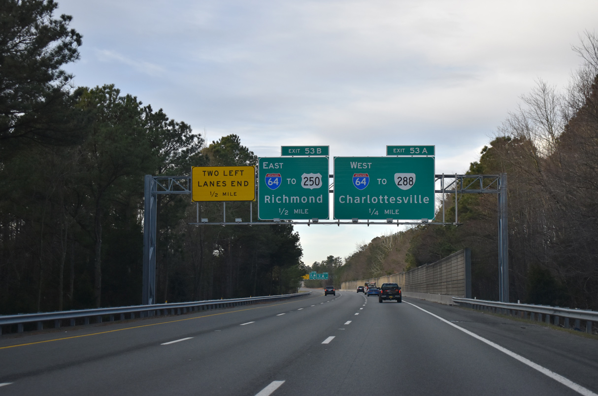
Exit 53A leaves I-295 northbound for Interstate 64 west to Charlottesville and Virginia Route 288 south to Midlothian. 12/30/20

Exit 53B follows a dual lane drop ahead of a roadway stub at the southbound end of Interstate 295. 12/30/20

Interstate 64 east connects with U.S. 250 nearby at Short Pump. 12/30/20
![]() East at
East at ![]()

Traveling east from SR 288 and the Goochland County line, Interstate 64 progresses 1.5 miles to Exit 177 with I-295 southbound. 12/16/16

Construction from 2006 to May 2009 added a two lane flyover (Exit 177) for I-295 southbound from I-64 east. Work also added a third eastbound lane for I-64 and removed the loop ramp and overpass formerly linking with I-295. Photo by Will Weaver (06/28/09).

A fourth lane opens ahead of the Pouncey Tract Road overpass and Exit 177. Interstate 295 provides a long distance bypass for I-64 eastbound destinations such as Williamsburg and Virginia Beach. Photo by Will Weaver (06/28/09).

Exit 177 departs Interstate 64 east for I-295. Interstate 295 connects with I-95 north to Fredericksburg and Washington, DC in ten miles. Photo by Will Weaver (06/28/09).
![]() West at
West at ![]()

Westbound I-64 crosses the retail strip along U.S. 250 (Broad Street) at Short Pump 0.75 miles ahead of Interstate 295 at Exit 177. Photo by Will Weaver (06/28/09).

An auxiliary lane was added to westbound Interstate 64 from U.S. 250 (Broad Street) to I-295 south in 2009. 12/16/16

Exit 177 for I-295 leading east toward Glen Allen was expanded to two lanes in 2009. I-64 heads 56 miles west to Charlottesville. 12/16/16
 North End Throwback

06/17/05
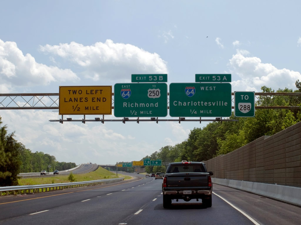
These overheads were replaced by 2014 with a new sign bridge added a half mile ahead of Exit 53A. The sign for Exit 53A however still references a quarter mile to I-64 west. Photo by Will Weaver (05/31/09).

Photo by Will Weaver (05/31/09).

Photo by Will Weaver (05/31/09).
South End – Petersburg, Virginia
![]() South at
South at ![]()

Heading south from U.S. 460, Interstate 295 navigates through a broad S-curve by Hanzik Pond to I-95. 01/04/19
Exit 1 leads motorists back north into Petersburg, where Interstate 95 connects with I-85 south to Durham, North Carolina. 01/04/19

Traffic along I-295 continues another 0.75 miles beyond Exit 1 to merge with the inside lanes of Interstate 95 southbound. 01/04/19

Interstate 95 travels 36 miles south from I-295 to U.S. 58 in Emporia. Drivers taking Exit 1 will reach Interstate 85 south in 4.7 miles. 01/04/19
![]() North at
North at ![]()

The first sign for Interstate 295 north (Exit 46) precedes the modified diamond interchange (Exit 46) with U.S. 301. U.S. 301 shifts to the west side of I-95 leading into Petersburg. 12/21/18

Several diagrammatic signs display the bypass route of I-295 in the Petersburg and Richmond area. Referencing travel times calculated with ITS (Intelligent Transportation Systems) technology, this assembly at Exit 45 was added by 2016. 12/21/18

I-95 continues one mile north from U.S. 301 to the three-wye interchange (Exit 46) with Interstate 295 north. 12/17/20

Tavern Road (SR 626) spans I-95 a half mile ahead of the separation with Interstate 295. I-295 returns to I-95, 44.5 miles to the north in Henrico County. 12/17/20

Exit 46 parts ways with I-95 north beyond the bridge across Second Swamp. I-295 runs east of Richmond International Airport (RIC) 26 miles to the north between SR 895 (Pocahontas Parkway) and U.S. 60. 12/17/20

Interstate 95 travels north through Petersburg to Colonial Heights and Chesterfield County. I-295 loops east between Fort Gregg-Adams and the city of Hopewell to the Varina-Enon Bridge. 12/21/18
![]() South at
South at ![]()

U.S. 460 separates from I-95 south at a cloverleaf interchange (Exit 48A) 1.75 miles north of I-295. U.S. 460 follows Wagner Road east to SR 106, where it turns south to meet Interstate 295 at Exit 3. 01/01/17

Progressing south, I-95 converges with Interstate 295 (Exit 46) a half mile beyond the exchange with SR 629 (Rives Road). 12/30/20

Left Exit 46 departs from I-95 south for Interstate 295 north to Hopewell. A carbon copied sign references the former lane drop that took place at the I-95/295 southbound merge. 12/30/20
Sources:
- “New I-295 Bridge Opens to Traffic as Work Goes on.” Richmond Times-Dispatch (VA), July 19, 1990.
- “A $20 Billion Traffic Jam – Virginia’s Highway Experts are Looking for a Way Out of Seemingly – Endless Problem.” Richmond Times-Dispatch (VA), June 1, 1986.
- “Board Awards I-295 Contract.” Richmond Times-Dispatch (VA),December 20, 1990.
- “I-295 Section East of City to Open Today.” Richmond Times-Dispatch (VA), October 7, 1988.
- “I-295 Section to Hopewell is Opened.” Richmond Times-Dispatch (VA),January 21, 1992.
- “State Opens Last Portion of I-295.” Richmond Times-Dispatch (VA), June 26, 1992.
Page updated July 28, 2021.