Interstate 140 Tennessee
Overview
Interstate 140 is both Pellissippi Parkway and Tennessee State Route 162. The suburban freeway angles southeast from SR 162 and I-40/75, west of Knoxville, to a bridge across the Tennessee River and SR 333 (Topside Road). The interstate designation ends at U.S. 129, while Pellissippi Parkway continues south as SR 162 to SR 33 near Alcoa.
The State Route 162 Pellissippi Parkway Extension will lengthen the highway southeast to U.S. 321. Providing part of a through route to Great Smoky Mountains National Park, Pellissippi Parkway will further improve traffic with the completion of Foothills Parkway from U.S. 321 southwest to U.S. 129. Maintained by the National Park Service (NPS), the 1.65 mile long gap in Foothills Parkway opened to the public on November 10, 2018. Costing $321 million, final paving for the 16 mile segment was funded by a Transportation Investment Generating Economic Recovery (TIGER) VIII grant, the NPS Federal Lands Transportation Program and the state of Tennessee.12
The Tennessee IMPROVE Act signed on April 26, 2017 estimated $61 million for completion of Pellissippi Parkway Extension. A Record of Decision for the project was issued on August 31, 2017. Funds for right-of-way acquisition and staged construction were budgeted in the Tennessee Department of Transportation (TDOT) three year plan for Fiscal Year 2020.13
A public meeting for the Pellissippi Parkway extension was held by TDOT on September 21, 2021. Following the public comment period that concluded on October 12, 2021, the project entered the design phase. The right of way process may start by the end of 2022, with 24 to 30 months to complete the needed property acquisition. Before any work can commence no earlier than 2025, construction funds must be identified in the first year of the three year projection budget TDOT publishes each year.14

Improvements underway for U.S. 129/SR 115 (Alcoa Highway) through Alcoa and Maryville include realigning the route onto a controlled access highway. The new corridor will branch south from the arterial route taking U.S. 129 southwest to McGhee Tyson Airport (TYS) to a new cloverstack interchange to be built with I-140/SR 162 (Pellissippi Parkway). The existing cloverleaf interchange at Exit 11 will be subsequently removed, with the exception of a single exit ramp from Interstate 140 east. Right of Way acquisition for State Route 115 at Pellissippi Parkway was underway in 2020 and continues through 2022.
 History
Interstate 140 was approved by the American Association of State Highway and Transportation Officials (AASHTO) Special Committee on Route Numbering on June 13, 1992. The first portion of the freeway finished was a 6.6 mile long segment including the Fort Loudoun Lake bridge. Traveling north from U.S. 129 (Alcoa Highway) to Northside Drive, the section was completed December 4, 1992.4 The bridge and a stretch of freeway south to Wrights Ferry Road was completed in August 1990 but not opened to traffic. The second section of I-140 extended northward four miles to Kingston Pike (U.S. 11/70) on October 6, 1993.7.
The I-140 link with I-40/75 and SR 162 followed on December 16, 19968, though all ramps between the two freeways were not completed until Spring 1997. A 1.1 mile long extension east from U.S. 129 (Alcoa Highway) to Cusick Road opened by December 22, 1996.8
Work on the $11.7 million extension of SR 162 to Old Knoxville Highway (SR 33) began in 2000. It was finished on August 15, 2005.9 Interstate 140 was resurfaced between May and September 2004.3
Route Information
East End – Alcoa, TN
West End – Knoxville, TN
Mileage – 11.17
Cities – Knoxville, Alcoa
- Junctions –

Source: December 31, 2021 Interstate Route Log and Finders List
I-140 Annual Average Daily Traffic (AADT)
Source: Tennessee Department of Transportation (TDOT) Transportation Data Management System 2021 AADT

State Route 162 Pellissippi Parkway Extension
The Tennessee Department of Transportation (TDOT) plans further extended Pellissippi Parkway southeast 4.38 miles to U.S. 321 east of Maryville.5 TDOT was set to commence with construction but never did due to a lawsuit filed by the Citizens Against the Pellissippi Parkway Extension (CAPPE) on June 7, 2002. CAPPE argued that TDOT had not completed an adequate Environmental Impact Statement (EIS) for the planned roadway. A federal judge agreed and placed an injunction against TDOT on July 17, 2002, halting construction activities.13
The U.S. District Court issued an order in August 2004 modifying its previous injunction, which allowed TDOT to reissue its environmental documents regarding SR 162 / Pellissippi Parkway. On September 27, 2004, TDOT announced the preparation of the environmental impact statement for the extension.4
Approval for the Pellissippi Parkway Draft Environmental Impact Statement (DEIS) followed on April 14, 2010 and the Final EIS (FEIS) on September 10, 2015. Alternate A was endorsed by the Maryville City Council on October 4, 2011 and the Alcoa City Commission on October 11, 2011. The Blount County Commission voted to send a recommendation for Alternate A on October 11 as well.10 The record of decision (ROD) for the project was signed by FHWA on August 31, 2017.
 Photo Guides
East End  – Alcoa, Tennessee
![]() East at
East at ![]()
![]()

A cloverleaf interchange (Exits 11B/A) joins the east end of Interstate 140 with U.S. 129 (Alcoa Highway) on the north side of Alcoa. 01/16/19

Exit 11A departs from I-140 east for U.S. 129 (Alcoa Highway) south. U.S. 129 travels four miles into Alcoa and six miles to the Blount County seat of Maryville. 01/16/19

U.S. 129 concludes eight miles north from Exit 11B at Interstate 40 in Knoxville. 01/16/19

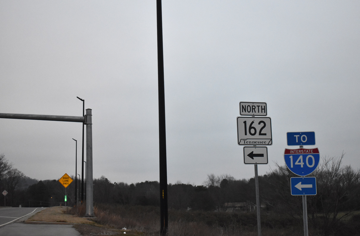
An end shield for Interstate 140 stands ahead of the entrance ramp from U.S. 129 north to SR 162 south. SR 162 (Pellissippi Parkway) extends the freeway another 2.54 miles to SR 33 (Old Knoxville Highway). 01/16/19

The previous end shield posted within the exchange joining I-140/SR 162 with U.S. 129 (Alcoa Highway). 08/23/03
![]() North at
North at ![]()
![]()

SR 162 (Pellissippi Parkway) leads northwest from SR 33 by the town of Rockford to become Interstate 140 at the exchange (Exit 11) with U.S. 129. 01/16/19

The southern segment of SR 162 concludes along Pellissippi Parkway as I-140 west takes over from U.S. 129. 01/16/19

Exit 11A follows for U.S. 129 (Alcoa Highway) south to Alcoa. Interstate 140 advances north to SR 333 (Topside Road) and the bridge spanning the Tennessee River. 01/16/19
![]() North at
North at ![]()

U.S. 129 (Alcoa Highway) northbound at the loop ramp for Interstate 140 west. Photo by Chris Patriarca (07/12/03).
![]() South at
South at ![]()

U.S. 129 (Alcoa Highway) south reaches the westbound entrance ramp for Interstate 140 toward Oak Ridge. 11/08/09
West End  – west Knoxville, Tennessee
![]() West at
West at ![]()
![]()
![]()

The last mainline interchange along I-140 connects with U.S. 11/70 (Kingston Pike). The commercial arterial parallels I-40/75 west to the town of Farragut and east to West Town Mall in Knoxville. 11/08/09

I-40 east / I-75 north overlap 8.7 miles east from Interstate 140 into Knoxville. The two separate at Marble City ahead of Downtown. 11/08/09

Crossing over Parkside Drive, I-140 (Pellissippi Parkway) enters the three quarter cloverleaf interchange with I-40/75. 11/08/09

Interstate 140 concludes just past Exit 1D for I-40 west to Nashville and I-75 south to Chattanooga. Pellissippi Parkway (SR 162) extends north along a controlled access expressway to Solway and SR 62. 11/08/09
![]() East at
East at ![]()
![]()

SR 162 (Pellissippi Parkway) southbound transitions into Interstate 140 east leading into the exchange with I-40/75. 01/16/19

Two lanes separate from Interstate 140 east for I-40/75. SR 162 emerges from I-140 in 12.2 miles along Pellissippi Parkway in Alcoa. I-40/75 combine for 17 miles between Eaton Crossroad and I-640 in Knoxville. 01/16/19
![]() East
East ![]() North at
North at ![]()
![]()

I-40/75 run between a large industrial park and an array of auto dealerships east from Lovell to the cloverleaf interchange with I-140/SR 162 (Pellissippi Parkway). 11/03/11
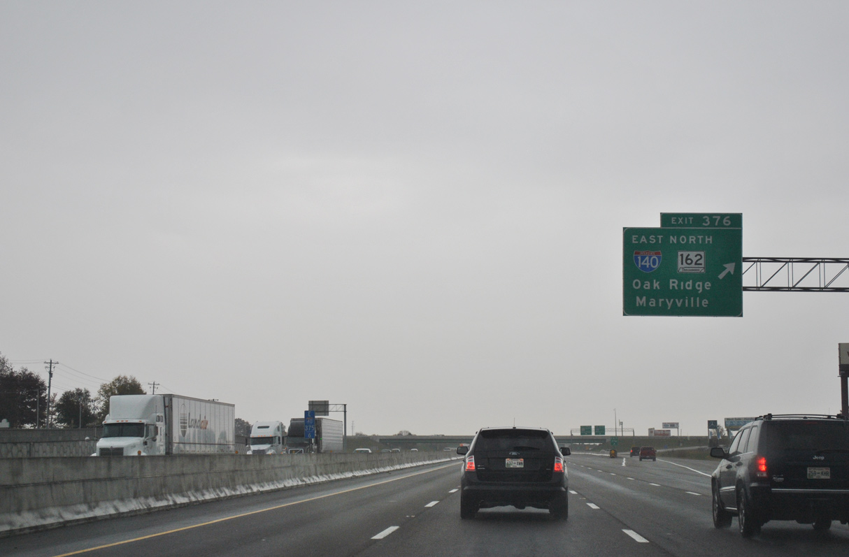
A distributor roadway separates at Exit 376 for I-140 east to Alcoa and Maryville and SR 162 west toward Oak Ridge via SR 62. 11/03/11
![]() West
West ![]() South at
South at ![]()
![]()

0.75 miles ahead of the collector distributor roadway (Exit 376) for Interstate 140 and SR 162. 06/25/12

Exit 376 separates from the I-40/75 westbound mainline for SR 162 north toward Oak Ridge and I-140 east toward Maryville. 06/25/12

I-40 west and I-75 south continue with four lanes through the exchange with I-140 and SR 162 (Pellissippi Parkway). Interstate 75 travels 91 miles southwest to I-24 at Chattanooga. I-40 combines with I-24 west through Nashville in 163 miles. 06/25/12

Traffic partitions with a two-lane ramp (Exit 376A) for SR 162 (Pellissippi Parkway) north. SR 162 travels 5.89 miles northwest to SR 62 by Melton Hill Lake. 06/25/12

Exit 367B loops onto I-140 (Pellissippi Parkway) east to Alcoa and Maryville. 06/25/12
Sources:
- Fred Corum, Regional Director TDOT.
- “Beltway OK’d.” Knoxville News, November 11, 2003.
- Tennessee Department of Transportation (TDOT). (2004, May 5). I-140/Pellissippi Parkway Advisory. http://web.archive.org/web/20080812044031/http://www.tdot.state.tn.us/news/2004/050504.htm
- Tennessee Department of Transportation (TDOT). (2004, September 27). TDOT Takes Next Step in Pellissippi Parkway Extension Project: Environmental Impact Statement is being prepared. http://web.archive.org/web/20080812043919/http://www.tdot.state.tn.us/news/2004/092704.htm
- “Traffic Travels Over New Part of Pellissippi more than 1,500 Cars an Hour Figured.” Knoxville News Sentinel (TN), December 5, 1992.
- “Pellissippi Parkway Extension Eventuallly will Link three ET Counties.” Knoxville News-Sentinel (TN), October 28, 1990.
- “New Portion of Pellissippi Parkway Opens.” Knoxville News-Sentinel (TN), October 7, 1993.
- “Pellissippi Parkway Link Opens.” Knoxville News-Sentinel (TN), December 18, 1996.
- “Alcoa Highway TO Cusick Road Stretch Opens.” Knoxville News-Sentinel (TN), December 22, 1996.
- “Pellissippi extension to open.” Daily Times, The (Maryville, TN), August 9, 2005.
- Alcoa backs Pellissippi Extension Alternate A. (2011, October 12). The Daily Times.
- Prohov, J. (2018, October 25). ‘Missing Link’ to open 52 years after construction began on Foothills Parkway. WBIR. https://www.wbir.com/article/news/local/missing-link-to-open-52-years-after-construction-began-on-foothills-parkway/51-607970435
- “Federal Highway Administration approves route for Pellissippi Parkway Extension.” The Daily Times (Maryville, TN), September 12, 2017.
- “Pellissippi Parkway extension process to start by end of year.” Daily Times, The (Maryville, TN), May 8, 2022.
Page updated May 18, 2022.