Interstate 89


Overview
Interstate 89 is a scenic highway serving the states of Vermont and New Hampshire in northern New England. The freeway joins the capital cities of Montpelier and Concord as part of its northwestern route from outside Concord to Lebanon, Burlington and Lake Champlain. Continuing northward from Swanton, Interstate 89 transitions into Quebec Route 133, which leads north to Autoroute 35 (A-35).
A-35 (Forts Valley Highway) extends 25 miles south from A-10 and Chambly in the Montréal suburbs to Route 133 in Saint-Sébastien, Quebec. Proposed to link directly with Interstate 89 since the 1960s, construction finally broke ground on August 27, 2020 for the 8.9 kilometer (5.6 miles) long section between Saint-Sébastien and Saint-Armand. Costing $222 million, phase III of A-35 takes the freeway southeast to Route 133 at Champlain and du Moulin in Saint-Armand, where an interchange was built. Slated to start in 2023, Phase IV builds the final 4.5 kilometers (2.8 miles) of the highway south to the U.S. border at Highgate, Vermont. The Quebec Ministry of Transportation (MTQ) anticipated full completion of construction in 2025,5,6 though WCAX out of Burlington, Vermont reported the completion was expected by 2026.9
Phases I and II previously extended A-35 south from Route 133 at Saint-Jean-sur-Richelieu to Route 133 west of Pike River. Completed in 2014, the projects totaled around $200 million in costs.7
The Vermont Agency of Transportation (VTrans) added supplemental signs displaying the milepoint to exit signs along Interstate 89 and other limited access highways statewide by the end of Spring 2020. The addition aimed to defer a Federal Highway Administration (FHWA) requirement made in 2009 that all exit numbers use a mileage based system. Vermont still uses sequential exit numbering, and the addition of milepoint exit placards allows the existing signs to remain in place to the end of their service life.8
The Milepoint Exit Numbering System assigned 1 A/B to the previously unnumbered exchange with Interstate 91 at White River Junction. Exit 22 with U.S. 7 at Highgate Springs is Milepoint Exit 129.
Anticipated construction converting the exchange joining I-89 with U.S. 2/7 (Colchester Road) at Winooski, Vermont into a DDI starts in Fall 2024. Phase 2 work building the first diverging diamond interchange in the Green Mountain State runs to Summer 2026. Phase 1 work, including utility relocation, retaining wall construction and other preliminary activities, got underway in Winter 2023 and wraps up in Fall 2023.
A five year, $43.8 million project reconstructs and expands the bridges taking Interstate 89 across the Connecticut River between White River Junction, Vermont and Lebanon, New Hampshire. Work on the bridges built in 1966 commenced in September 2020. Traffic patterns changed in May 2022 as crews shifted focus to erecting structural steel joining the two separate spans. Southbound traffic shifted onto the median bridge while work proceeded on replacing the deck of the original lanes. Subsequent work focuses on the northbound span. Upon completion in September 2025, auxiliary lanes will run in both directions of I-89 between I-91 at Exit 1 and New Hampshire Route 12A at Exit 20.10
 Parallel U.S. Routes
Interstate 89 follows an independent alignment northwest from Concord to Lebanon, where U.S. 4 ties in from Enfield to the east. U.S. 4 parallels I-89 for 11 miles to White River Junction and Hartford in Vermont. Northwest from there, I-89 replaced VT 14 as the main route to Barre and Montpelier.
U.S. 2 accompanies the freeway west from Montpelier to South Burlington, shifting sides with I-89 several times. U.S. 7 combines with U.S. 2 north from Burlington to Colchester. U.S. 2 turns west through the Lake Champlain Islands while U.S. 7 remains along the I-89 corridor to the Canadian border at Highgate.
History
Interstate 89 opened initially in New Hampshire between Warner and New London in November 1967. Completion within the state followed a year later.`
Within Vermont, Interstate 89 was built in stages through the 1960s:1
- Montpelier to Middlesex (6.287 miles) – November 21, 1960
- Middlesex to Waterbury (5.106 miles) – December 31, 1960
- Waterbury to Bolton (7.049 miles) – November 20, 1961
- South Burlington to Winooski (3.388 miles) – November 29, 1962
- Winooski to Colchester (1.184 miles) – November 1, 1963
- Richmond to South Burlington (8.723 miles) – November 6, 1963
- Bolton to Richmond (6.745 miles) – October 30, 1964
- Colchester (6.486 miles) – November 1964
- Swanton to Highgate (5.538 miles) – 1965

The last stretch of Interstate 89 constructed ran south from Memorial Drive at Montpelier to the temporary end at VT 14 by West Hartford.
Route Information
Mileage
New Hampshire – 60.87
Cities – Concord, Lebanon
- Junctions –

Vermont – 130.25
Cities – Montpelier, Waterbury, Burlington, St. Albans, Swanton
- Junctions –

Source: December 31, 2021 Interstate Route Log and Finders List
I-89 Annual Average Daily Traffic (AADT)
Source: NHDOT Traffic Volume Reports 2013, 2015 AADT
2018 (Route Log) AADTS – State Highways (VTrans)

Interstate 89 was complete by 1963 from a temporary end west of Bolton to Memorial Drive at Montpelier, and from I-189 to U.S. 2 (Main Street) at South Burlington. Construction was underway north to Winooski and from Swanton to the Canadian border.
North Carolina
The North Carolina Department of Transportation (NCDOT) submitted an application for designating Interstate 89 at the American Association of State Highway and Transportation Officials (AASHTO) Special Committee on U.S. Route Numbering meeting on May 24, 2016.3 The new route number was proposed to join Raleigh with Hampton Roads, Virginia along the U.S. 64 freeway corridor between Knightdale and Williamston, and U.S. 17 northeast from Williamston to the Virginia state line. AASHTO ultimately approved Interstate 87 for the new corridor.4
 Photo Guides
North End – Canadian International Border – Highgate, Vermont
![]() North at
North at ![]()

Advancing north from Rock River Bay, Interstate 89 and U.S. 7 converge at a folded diamond interchange (Exit 22 / Milepoint Exit 129) in three quarters of a mile. 03/24/23

Exit 22 to U.S. 7 in the town of Highgate represents the last departure point from Interstate 89 north ahead of the port of entry into Quebec, Canada. 03/24/23

U.S. 7 loops southward to Rock River off Lake Champlain en route to the community of Highgate Springs. Local roads, Borderview Road and Country Club Road, tie into the exchange as well. 10/08/14
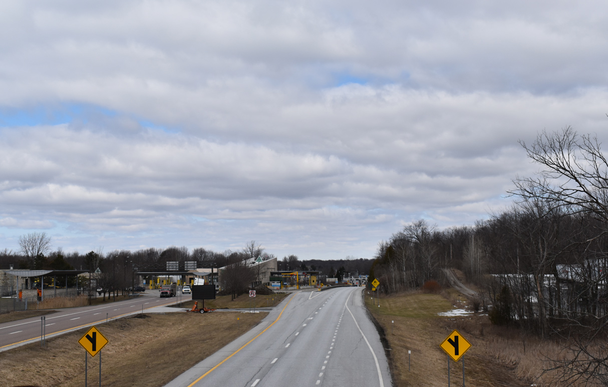
Interstate 89 north at the International Border and transition to Quebec Route 133. 03/24/23
![]() at
at ![]()

U.S. 7 north concludes at Country Club Road and the southbound entrance ramp to Interstate 89 in Highgate. 03/24/23

The ramp from U.S. 7 and Country Club Road is the first access point for I-89 within the U.S. The freeway mainline extends south from the U.S. customs station and Quebec Route 133. 03/24/23

U.S. 7 runs from I-95 at Norwalk, Connecticut to I-89 at Highgate, Vermont. 03/24/23

U.S. 7 north at the entrance ramp for I-89 north to Quebec Route 133. 03/24/23

U.S. 7 crosses over Interstate 89 ahead of the loop ramp for the connection with Quebec Route 133 north into Saint-Armand, Canada. 08/01/07
![]() South
South

The first confirming marker for Interstate 89 south. U.S. 7 shifts to the west side of the freeway on the ensuing stretch to Highgate Springs and Swanton. 03/24/23
South End 
 – Concord, New Hampshire
![]() South at
South at ![]()
![]()
![]()

Interstate 89 runs southeast between Silver Hill and Cilley State Forest on the two mile approach to I-93 outside Concord. 10/06/14

Entering the town of Bow, I-89 curves eastward to a folded diamond interchange (Exit 1) with Logging Hill Road. The exchange with Interstate 93 and the access road to NH 3A at Bow Junction follows. 10/06/14

A pair of end signs for Interstate 89 stand three quarters of a mile west of the half cloverleaf interchange with I-93 and the F.E. Everett Turnpike south. 10/06/14

Exit 1 departs I-89 south for Logging Hill Road south to Bow and north to South Street in Concord. Interstate 93 parallels the Merrimack River nearby between the capital city and Manchester. 10/06/14
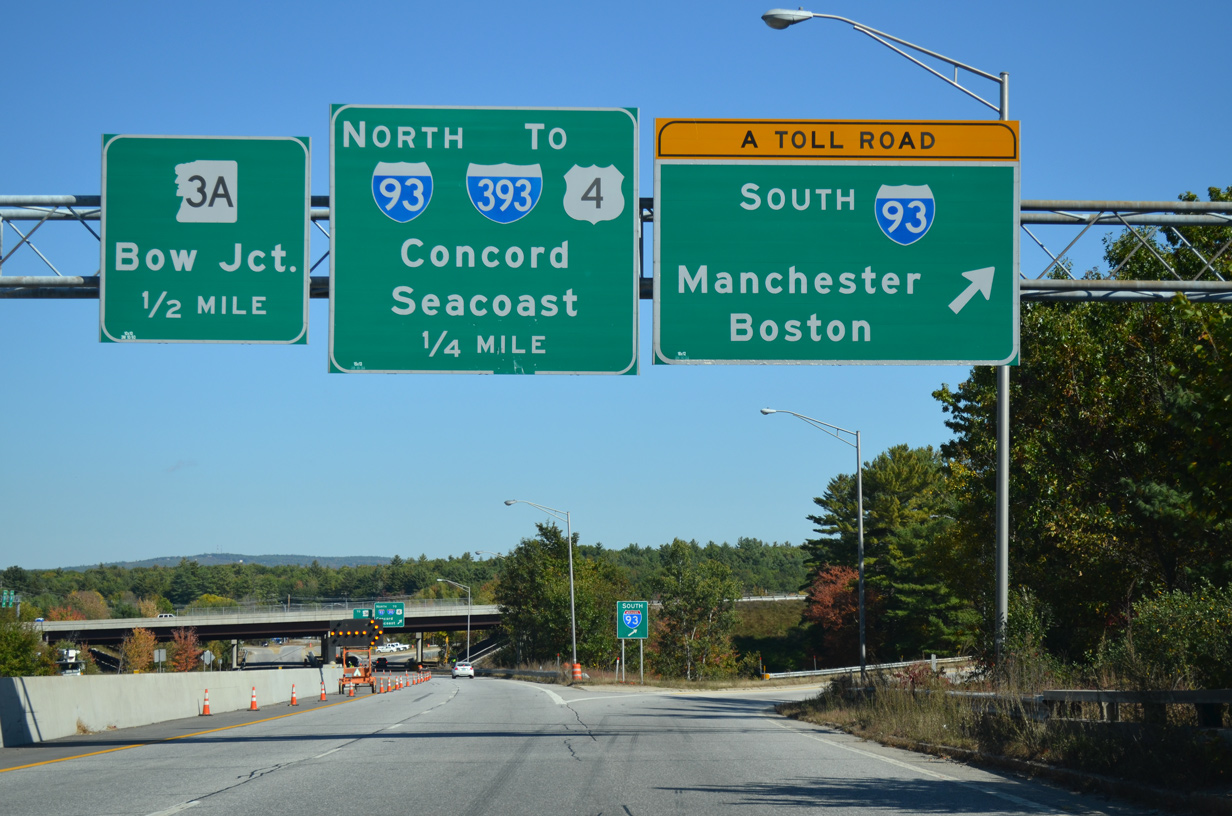
Traffic to I-93 (F.E. Everett Turnpike) south to Boston, Massachusetts leaves I-89 south. The toll road coincides with I-93 to Hooksett and the split with I-293 around Manchester. 10/06/14

Overpasses carrying Interstate 93 and the c/d roadway for I-89 were replaced during freeway expansion competed by 2014. Traffic separates with a loop ramp joining I-93 north into Concord and the access road linking with NH 3A at Hall Street in Bow. 06/27/05
![]()
![]() North at
North at ![]()

Interstate 93 (F.E. Everett Turnpike) heads north from the Hooksett Rest Area along an uninterrupted stretch into the town of Bow. The unnumbered exit for Interstate 89 departs next. 10/06/14

Interstate 89 branches northwest from I-93 along a winding and hilly course to Sunapee Lake, Shaker Mountain and Lebanon near the Vermont state line. 10/06/14

A collector distributor roadway separates from I-93 north in half mile for Interstate 89 north. I-89 connects the Boston area with Canada via I-91 at White River Junction, Vermont and Quebec Route 133 north of Highgate Springs. 10/06/14

Grandview Road crosses over I-93 north at the c/d roadway for Interstate 89 north. I-93 continues north toward Downtown Concord while I-89 passes through western reaches of the city to Little Turkey Pond. I-393 stems east from I-93 in four miles along side U.S. 4/202 toward Portsmouth. 10/06/14
![]() South at
South at ![]()
![]()

NH 3A (S Main Street) crosses over I-93 at a six-ramp parclo interchange (Exit 12) just ahead of Bow Junction and the south end of Interstate 89. 08/21/21

Curving southward across the Bow town line, I-93 approaches the half cloverleaf interchange with Interstate 89 north. The forthcoming exchange represents the north end of the tolled F.E. Everett Turnpike as well. The Turnpike extends south to Hooksett and from I-293 at Manchester to U.S. 3 at Nashua. 06/27/05

A third southbound lane was added along Interstate 93 from NH 3A to I-89 and the F.E. Everett Turnpike in 2015. Interstate 89 initially heads west to Hopkinton, connecting with U.S. 202 to Henniker. 06/27/05
![]() / Hall St at
/ Hall St at ![]()

Northbound Interstate 89 originates from NH 3A just east of the half cloverleaf interchange with I-93 in Bow. 08/21/21

Hall Street ties into the intersection joining NH 3A and the northbound beginning of Interstate 89 from the east. 08/21/21

NH 3A advances less than a half mile south from ramps with I-93 at Exit 12 to the intersection with Hall Street where Interstate 89 north begins. 08/21/21
South End Throwback


All guide signs for Interstate 89 on I-93 (F.E. Everett Turnpike) northbound were replaced by 2007. 06/27/05

A diagrammatic sign formerly outlined the loop ramp from the c/d roadway to I-89 north at the Grandview Road overpass. Photo by Michael Summa (1977).

A previous end sign was posted for I-89 a half mile west of Interstate 93. Photo by Jeff Royston (12/02).

The NH 3A overpass a half mile north of I-89 on I-93 south was replaced during construction in 2014-15. 06/27/05
Sources:
- “100th Anniversary Series Part III – The Interstate Highway System.” New Hampshire Highways, May / June 2004 edition.
- Outline History of Vermont State Highways – National Highway Week, September 19-25, 1965. Prepared for informational purposes only by the Vermont Department of Highways.
- Special Committee on U.S. Route Numbering meeting scheduled for May 24, 2016, agenda packet, AASHTO 2016 Spring Meeting in Des Moines, Iowa.
- “North Carolina Gains Names for Two New Interstate Designations.” North Carolina Department of Transportation, press release. May 25, 2016.
- “Third phase of Quebec’s Highway 35 extension project begins.” Global News, August 27, 2020
- “Scott congratulates Quebec on Autoroute 35 groundbreaking.” Vermont Business Magazine, August 28, 2020
- “L’autoroute 35 sera complétée d’ici 2023.” TVA Nouvelles, October 9, 2019.
- “Changes coming to Vermont highway exit signs.” WPTZ TV-5 (Plattsburgh, NY), December 12, 2019.
- “Construction progress on Autoroute 35 to Montreal.” WCAX TV-3 (Burlington, VT), September 10, 2022.
- “I-89 bridge work to alter traffic patterns.” Valley News (West Lebanon, NH), May 9, 2022.
Page updated March 30, 2023.