Interstate 12

Overview
Interstate 12 functions as a bypass route for I-10 north of Lake Pontchartrain and the New Orleans metropolitan area. Although an intrastate route, I-12 provides a significant role in cross country travel.
The freeway splits with Interstate 10 in Baton Rouge as a busy commuter route through suburban areas east to Denham Springs. Six lane expansion of I-12 east from Exit 7 / LA 3245 (O’Neal Lane) to Exit 15 / LA 447 at Walker was completed in April 2013.6 Continuing east, I-12 becomes more rural through areas of pine forest, but still with moderate traffic given it accommodates just four overall lanes.
Interstate 55 crosses paths with I-12 outside Hammond, the largest city between Baton Rouge and Slidell. The freeway passes south of the city street grid and quickly exits the area toward Covington and the Lake Pontchartrain North Shore communities of Madisonville and Mandeville. There U.S. 190 ties in from the north end of Lake Pontchartrain Causeway, a lengthy toll bridge leading south to Metairie and Jefferson Parish west of New Orleans.
The remainder of Interstate 12 leads east through St. Tammany Parish to Slidell and the junction with I-10 and I-59 north. The freeway passes through North Slidell and suburban areas before defaulting onto I-10 east across Pearl River Wildlife Management Area into Mississippi. Expansion work along Interstate 12 bringing the freeway up to six lanes in the area of Convington and Mandeville got underway in May 2020. A $54 million, two and a half year project expanded 3.023 miles of I-10 from U.S. 190 to LA 59, with lanes added in the median. Costing $59.1 million, two years of subsequent work started in Fall 2020 widened I-12 west from U.S. 190 to LA 21. Once funding is identified, the third phase adds lanes from LA 21 west to LA 1077.7
$25.7 million in construction expanding Interstate 12 from four to six lanes east from the Vincent’s Bayou Bridge to I-10/59 commenced in January 2011. Work was finished in Summer 2012.8
 Parallel U.S. Routes
Interstate 12 replaced U.S. 190 as the through route north of Lake Pontchartrain. U.S. 190 parallels I-12 to the north from Baton Rouge east to Covington and to the south between Mandeville and Slidell.
Interstate 12 Extension
The Louisiana Statewide Transportation Plan Update in 2003 outlined a limited access highway looping northeast from I-10 west of LA 415 in West Baton Rouge Parish near Port Allen to U.S. 190 and the Mississippi River Bridge. Named the Northern Baton Rouge Bypass, the corridor extended east from Scotlandville in Baton Rouge through Central and Denham Springs to Interstate 12 at Walker in Livingston Parish.1
The Northern Baton Rouge Bypass was listed as Megaproject Item LSTP-051 in the Louisiana Statewide Transportation Plan Update (December 2003). Megaprojects considered for construction were listed in the report under the first chapter. A southern bypass route was considered but was later removed from the plan due to the substantial environmental cost of building over sensitive lands. U.S. 190 between U.S. 165 and the Northern Baton Rouge Bypass, via Kinder, Eunice, Opelousas and Krotz Springs, was also being considered for upgrade to freeway standards as part of projects LSTP-056 and LSTP-057.1
The Northern Baton Rouge Bypass was planned as a future Interstate highway based on this excerpt from page C-1 of the Louisiana Statewide Transportation Plan Update report:1
Break out the Baton Rouge North Bypass from I-10 to I-12 (LSTP-051) to Priority A and B: Priority A – new Interstate I-12 from I-10 west of LA 415 to US 190 and bridge rehabilitation to Airline Highway, stop at Plank Road interchange. Move project from Priority B to Priority A ‘mega’ projects. Priority B – Plank Road interchange to I-12, build/upgrade to 4-lane interstate standards”.
Commissioned by the Capital Region Planning Commission (CRPC), a consultant study released on November 9, 2004 recommended the central route for the bypass. It would begin at Interstate 10 a few miles west of LA 415 in West Baton Rouge and connect with U.S. 190 just west of LA 1145. The bypass would then continue east along U.S. 190 across the Mississippi River and connect with U.S. 61 (Airline Highway) at Scotlandville, Baton Rouge. Northeasterly from there, the expressway would extend to a point a few thousand feet north of Hooper Road, then cross Blackwater, Sullivan, Hooper and Greenwell Springs Roads. Spanning the Amite River, the route would proceed east to LA 1026, Range Road, and LA 447 (Walker Road), then curve southeast to Interstate 12 between the Walker and Satsuma interchanges.2
The report recommended a six phase approach for building the highway:
- Phase One – Plank Road east to LA 16 (Range Road), $263 million, open 2012
- Phase Two – LA 16 (Range Road) east to LA 447 (Walker North Road), $76 million, open 2014
- Phase Three – LA 447 (Walker North Road) east to Interstate 12, $87 million, open 2014
- Phase Four – Interstate 10 east to U.S. 190/LA 1, $93 million, open 2016
- Phase Five – upgrade U.S. 190 from Phase Four segment east to Mississippi River Bridge, $72 million, open 2018
- Phase Six – upgrade U.S. 190 Mississippi River Bridge and extend freeway through northern Baton Rouge along U.S. 61-190 east to Plank Road, $319 million, open 2020
The CRPC consultant study in 2004 indicated it would cost $910 million to construct the expressway. This included spending $300 million for upgrading the U.S. 190 Mississippi River Bridge, which was built in 1940. Due to the high costs for construction of the bypass, many believed that the road should be deferred in favor of improving existing roads around the Baton Rouge metropolitan area, especially Interstate 12 and main arteries serving Downtown. Furthermore, one of the project’s chief critics, State Representative William Daniel, a Democrat from Baton Rouge, sued the CRPC to get the information about the costs of the corridor prior to the official release date of the study. Coupled with an expected completion date in 2020 and the prospect of tolls, critics were also skeptic about the project’s viability.2 The Northern Baton Rouge Bypass never advanced beyond early studies and discussion.
According to the journal Roads and Bridges, the I-12 corridor should be extended westward:
Interstate 12 Houston to Austin: These metropolitan areas have grown rapidly. Less than 100 miles, this route would require upgrading from Austin to Interstate 10 along the state route 71 corridor.
SH 71 is a four lane roadway for its entire length, with portions already upgraded to expressway standard. One upgrade along the SH 71 corridor is the SH 71 Express Project in Austin. Construction between early 2015 and late 2016 upgraded 3.9 miles of the highway, from Presidential Boulevard at AUS Airport to SH 130 near Onion Creek, to a limited access toll road. Work added two toll lane overpasses at FM 973 and SH 130.
Route Information
- East End – Slidell, LA
- West End – Baton Rouge, LA
- Branch Routes – 0
- Mileage – 85.59
Cities – Baton Rouge, Denham Springs, Walker, Hammond, Covington, Slidell
- Junctions –

Source: December 31, 2021 Interstate Route Log and Finders List
I-12 Annual Average Daily Traffic (AADT)
Source: LADOTD Estimated Annual Average Daily Traffic Routine Traffic Counts
2017 – East Baton Rouge 2015 Livingston 2016 Tangipahoa 2015 St. Tamminy
* – AADT between Exits 6 to 7 recorded in 2014

Work was also underway after 1963 on I-12 from LA 447 and the Ponchatoula Bypass, the first portion of I-55 opened to traffic in Louisiana.

Construction along I-12 continued in 1972 on the easternmost segment from LA 434 to I-10 and I-59.

Older signs displayed at Exit 1A from before expansion of I-12 west to three lanes for I-10 west. 01/18/96
History
Interstate 12 was completed between U.S. 61 (Airline Highway) at Baton Rouge and I-55 at Hammond in 1969. The western most two miles of I-12 opened in conjunction with Interstate 10 east from College Drive in 1965.3 Interstate 10 southeast from I-12 would not be completed until 1974, resulting in traffic defaulting from I-10 east onto I-12 and U.S. 61 until 1969.
The Louisiana State Legislature passed a resolution declaring Interstate 12 the West Florida Republic Parkway in 1993. This name acknowledges the West Florida Republic, which existed for 74 days between an 1810 revolt against Spain and the forced annexation of the eight parishes into the Louisiana Purchase by the United States. Signs were installed referencing I-12 as the West Florida Republic Parkway in mid November 2003.4
 Photo Guides
East End  – Slidell
![]() East at
East at ![]()
![]()

The first of in a series of guide signs for I-10 and I-59 north on Interstate 12 stands beside the U.S. 11 underpass at Exit 83. 05/09/15

Construction along Interstate 12 completed in 2012 added a lane in each direction between U.S. 11 and the exchange with I-10 and I-59 (Exit 85). The third eastbound lane defaults onto I-10 southwest to New Orleans. 05/09/15
Carrying commuters from the Northshore into New Orleans, I-10 crosses Lake Pontchartrain south from Slidell into New Orleans East. 05/09/15

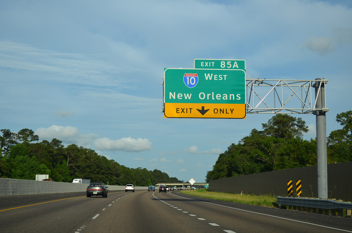
I-10 west overtakes the freeway leading south from I-59 and Picayune, Mississippi at Exit 85A. Four interchanges line I-10 west through the Northshore city of Slidell. 05/09/15


Exit 85 B loops onto Interstate 59 north. I-59 crosses the Mississippi state line in 11.5 miles near Nicholson and reaches Hattiesburg in 73 miles. 10/08/21
![]() West at
West at ![]()
![]()

Interstate 10 spans the West Pearl River two miles ahead of I-12 west and I-59 north. Photo by Jeff Royston (04/11/22).

The Louisiana Welcome Center precedes Exit 267. The tourist information center reopened on June 29, 2009 after two years of reconstruction. The $12 million project replaced the facility built in 1978.5 05/09/15

A third lane opens along Interstate 10 westbound for the continuation to New Orleans. Traffic to the right defaults onto I-12 westbound (Exit 267B) in one half mile. Exit 267A follows after the I-10/12 split for I-59 north. 05/09/15

Beyond their separation, I-10 and I-12 both serve the city of Slidell with succeeding interchanges. Interstate 12 reaches Hammond in 45 miles and I-10 travels 38 miles southwest to Downtown New Orleans. 05/09/15
![]() East at
East at ![]()
![]()

Left Exit 267B joins I-10 east with Interstate 12 west. I-59 travels 160 miles northeast to the overlap with I-20 east at Meridian, Mississippi. 05/11/22

Left exit tabs were added to guide signs in 2012 for I-12 west and I-59 north. I-12 converges with U.S. 11 in two miles at Exit 83. I-59 also meets U.S. 11 nearby; the two run concurrent north to Picayune, Mississippi. 04/20/12
![]() South at
South at ![]()
![]()

Advancing toward the Louisiana welcome center, 1.5 miles ahead of Interstate 12 west and I-10 on I-59 south. 10/08/21

Exit 1A leaves I-59 south for Interstate 12 west to Covington at the directional cloverleaf interchange with I-10. 10/08/21

I-59 south defaults onto Interstate 10 west to New Orleans beyond the loop ramp (Exit 1B) connecting with the end of I-12 to I-10 east to Bay St. Louis, Mississippi. 10/12/16
![]() West
West

The first westbound shield for Interstate 12 appears beyond the LA 1091 (Robert Boulevard) overpass. 05/19/14
East End Throwback
![]() East at
East at ![]()
![]()

The previous set of guide signs for I-10 and I-59 were installed in Spring 2000. A concrete barrier replaced the grassy median during eventual six lane expansion of Interstate 12 east to Exit 85. 10/04/01

Interstate 12 east concludes at the separation of Exit 85B for Hattiesburg and Exit 85C for the Mississippi Gulf Coast. 10/04/01
West End – Baton Rouge
![]() West at
West at ![]()

Entering the half diamond interchange (Exit 1C) with LA 1068 (Drusilla Lane) and LA 73 (Jefferson Highway), Interstate 12 makes the final approach to I-10. 05/19/14

Four lanes of I-12 proceed west from the Essen Lane entrance ramp to the three-wye interchange (Exit 1A) with Interstate 10. A lane drop occurs at the eastbound ramp back to New Orleans. 05/19/14

The westbound mainline of I-12 defaults onto Interstate 10 west ahead of the commercialized interchange with College Drive. Downtown Baton Rouge lies five miles to the northwest. 05/19/14
![]() East at
East at ![]()

Interstate 10 advances east from the parclo interchange (Exit 158) with College Drive 1.5 miles to split with I-12 at Exit 159. 05/19/14

A fourth eastbound lane emerges from the College Drive entrance ramp as Exit 159 prepares to depart with three lanes for Interstate 12 to east Baton Rouge, Denham Springs and Hammond. 05/19/14

Interstate 12 progresses east from Baton Rouge as a busy commuter route to Walker and the default through route for points east along the Gulf Coast. Interstate 10 remains with commuter traffic through to Gonzalez. 05/19/14

Interstate 12 east separates from I-10 east. Hammond lies 40 miles to the east via I-12 while I-10 east reaches LaPlace in 47 miles and New Orleans in 71 miles. 05/19/14

The first eastbound Interstate 12 reassurance shield appears just beyond the Exit 159 gore point from I-10 east. A half diamond interchange (Exit 1B) lies one mile ahead with LA 3064 (Essen Lane). 05/19/14
![]() West at
West at ![]()

A lane drop occurs along Interstate 10 west for I-12 east (Exit 159) beyond the diamond interchange (Exit 160) with LA 3064 (Essen Lane). 05/19/14

Interstate 10 passes through a wooded area proceeding the three-wye interchange (Exit 159) with Interstate 12 east. I-10 through traffic reduces to two lanes in each direction through the exchange. 05/19/14

Interstate 12 east serves a bevy of commuter traffic through the Southmoor, Cedarcrest and Sherwood neighborhoods areas of the city through to Denham Springs. 05/19/14

Exit 159 leaves Interstate 10 west for I-12 east to Hammond and the Northshore of Lake Pontchartrain. 05/19/14
West End Throwback
![]() West at
West at ![]()

Interstate 12 west at the off-ramp to LA 1068 (Drusilla Lane), 1.5 miles from I-10. Most signs for I-12 in Baton Rouge were changed to Clearview font based signs by 2013. 01/04/09

This set of signs for Interstate 10 and Exit 1A was carbon copied by 2013. There are no end Interstate 12 assemblies posted otherwise. 01/04/09

A sweeping flyover ramp (Exit 1A) carries motorists back southeast onto I-10 east as the mainline advances onto I-10 west with three lanes. 01/04/09
![]() East at
East at ![]()

Interstate 10 east at Exit 158 for College Drive, which is named for Baton Rouge Community College. The split with Interstate 12 eastbound lies 1.50 miles ahead. 10/22/03

Diagrammatic sign formerly posted along Interstate 10 east for the impending split with I-12. Sound walls were erected along this stretch in 2002.
All signs for I-12 along eastbound were replaced by 2013. 10/22/03

A sign replacement project underway during Spring 2000 coincided with expansion of Exit 159 to three lanes. 10/22/03

Interstate 12 begins as I-10 turned southeastward toward Gonzales, La Place and New Orleans. Suburban expansion of Baton Rouge spread eastward along the I-12 corridor to Exit 10 / LA 3002 at Denham Springs. 10/22/03
![]() West at
West at ![]()

I-10 west at LA 3064 (Exit 160) before expansion of both the freeway to six lanes and off-ramp to two lanes. LA 3064 comprises a 1.86-mile long route connecting LA 73 and 427. 10/18/03

This sign bridge was removed in 2011 when I-10 was expanded to incorporate a concrete barrier median. 10/18/03

Interstate 10 west at I-12 was upgraded to urban design standards here in 2011. 10/18/03
Sources:
- Louisiana Statewide Transportation Plan Update.
http://www2.dotd.louisiana.gov/study/ - “Bypass report shows $910 million, 6-phase plan.” Baton Rouge Advocate (LA), October 26, 2004.
- “Booklet for I-10 Dedication Ceremony.” Baton Rouge Digital Archive, September 18, 1964.
- “Signs on I-12 remind people of Florida Parishes republic.” Fox 8 Live WVUE-TV New Orleans, November 24, 2003.
- “I-10 welcome center reopens near Slidell.” The Times-Picayune, June 29, 2009.
- I-12 Widening O’Neal Lane Interchange to Walker. Lousiana Department of Transportation & Development (LADOTD), design-build project web page.
- “I-12 widening project to begin in St. Tammany Parish.” Lousiana Department of Transportation & Development (LADOTD), news release. May 4, 2020.
- I-12 Widening in St. Tammany Parish. Lousiana Department of Transportation & Development (LADOTD), project web page.
Page updated May 31, 2022.