Interstate 478 New York

Overview
Interstate 478 is an unmarked route following the Hugh L. Carey (Brooklyn-Battery) Tunnel from I-278 (Brooklyn Queens Expressway) at the Red Hook section of Brooklyn north to the southern tip of Manhattan. Operated by the Metropolitan Transportation Authority (MTA), the four lane tunnel uses all electronic toll collection through E-ZPass and toll by plate. Cashless toll collection commenced for the Hugh L. Carey Tunnel on January 3, 2017.1

Battery Park and the north entrance of the Hugh L. Carey (Brooklyn Battery) Tunnel from the World Trade Center in May 1999.
 History
The first proposed alignment for Interstate 478 extended south from the planned Lower Manhattan Expressway (I-78) across the Manhattan Bridge to the Brooklyn-Queens Expressway (I-278). The Manhattan Bridge, a suspension bridge built between 1901 and 1909, spans the East River between Canal Street in Lower Manhattan and Flatbush Avenue in Brooklyn. The Lower Manhattan Expressway was dropped in March 1971 and I-478 redesignated along the Brooklyn Battery Tunnel and proposed Westway.2
The Brooklyn Battery Tunnel opened to traffic on May 25, 19503 as the longest continuous underway vehicular tunnel in North America. The crossing took ten years to build.4 The tunnel was renamed after Brooklyn native Hugh L. Carey, a former Congressman and Governor of New York (1975-82) on October 22, 2012.3
Route Information
North End – Manhattan, New York, NY
South End – Brooklyn, New York, NY
Mileage – 2.14
Cities – New York City
- Junctions –

Source: December 31, 2021 Interstate Route Log and Finders List
I-478 Annual Average Daily Traffic (AADT)
| Location | Vehicles per day |
|---|---|
| I-278 to NY 9A | 43,895 |
Source: 2019 estimate NYSDOT Traffic Data Viewer

This was part of the planned Lower Manhattan Expressway, which would have taken I-78 across Manhattan from the Holland Tunnel east to the Williamsburg Bridge with I-478 branching south via the Manhattan Bridge.
Interstate 478 originally extended north as far as Mid-town Manhattan along the former elevated West Side Highway. The West Side Highway closed on December 16, 1973 from the Battery north to W 46th Street due to structural deficiencies and the collapse of a 60 foot long section at Gansevoort Street. The remainder closed afterwards to W 57th Street, with a temporary roadway built along West Street and 12th Avenue. Demolition of the elevated West Side Highway took place between 1977 and 1989.2 The route was formally dropped north of the Brooklyn Battery Tunnel as an Interstate highway by the American Association of State Highway and Transportation Officials (AASHTO) on November 8, 1986.
A replacement of the West Side Highway was approved in May 1993. The new roadway was constructed as a multi lane boulevard from April 1996 to August 2001 and signed as New York Route 9A.2
 Photo Guides
North End  – Manhattan, New York City, New York
![]() North at
North at ![]() FDR Drive
FDR Drive

Leaving the Hugh L. Carey (Brooklyn Battery) Tunnel, an exit connects I-478 with Trinity Place via Greenwich and Edgar Streets. 12/17/17

NY 9A (West Street) extends north along the Hudson River two miles to the Holland Tunnel (I-78) and five miles to the Lincoln Tunnel (MSR 495). Franklin D. Roosevelt (FDR) Drive runs along the East Side of Manhattan adjacent to the East River. 12/17/17
 North End Throwback

A pedestrian bridge spans I-478 just north of the Brooklyn Battery Tunnel at the exit for Trinity Place. Photo by Dan Moraseski (Winter 2001).

The north end of I-478 ties into NY 9A (West Street) beyond the Battery Parking Garage. 05/99
![]() South at
South at ![]()

Exit numbers for FDR Drive, an expressway encircling Manhattan along the East River, commence from NY 9A (West Street) south at the entrance for Hugh L. Carey (Brooklyn Battery) Tunnel at Thames Street. 05/30/22

A two lane ramp (Exit 2) lowers into a short tunnel ahead of the Hugh L. Carey (Brooklyn Battery) Tunnel entrance below Battery Park from NY 9A (West Street) southbound. 05/30/22

Unsigned I-478 descends from NY 9A (West Street) into the Hugh L. Carey (Brooklyn Battery) Tunnel beyond the toll collection point. 05/30/22
South End – Brooklyn, New York City, New York
![]() South at
South at ![]()
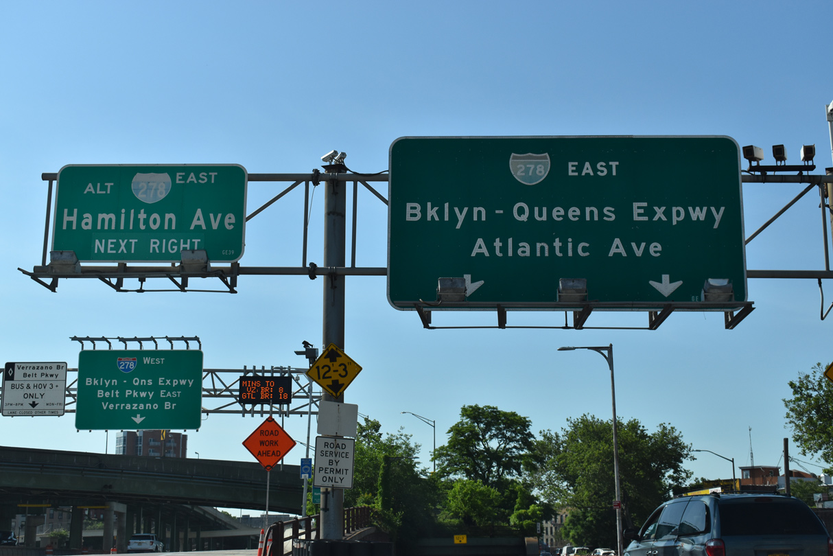
Traffic south through the Hugh L. Carey Tunnel emerges from the East River just ahead of I-278 at Red Hook in Brooklyn. Continuing past the site of the former toll plaza, I-478 partitions into ramps for the Gowanus Expressway south to Belt Parkway and Staten Island, Hamilton Avenue to Red Hook, and the Brooklyn Queens Expressway (BQE) east to Atlantic Avenue and Astoria in Queens. 05/30/22

The ramp for I-278 east from the Hugh L. Carey Tunnel south passes below the BQE through a tunnel and combines with an entrance ramp from Hamilton Avenue. 08/09/04
![]() East at
East at ![]()

Interstate 278 (Gowanus Expressway) angles northwest from the end of the Prospect Expressway (NY 27) across Gowanus Canal to Left Exit 25 for I-478 (Hugh L. Carey Tunnel) north to Manhattan. 12/17/17

A lane drop occurs at Left Exit 25 for the Hugh L. Carey (Brooklyn Battery) Tunnel, resulting in a bottleneck for eastbound traffic continuing along I-278 and the Brooklyn Queens Expressway (BQE). 12/17/17

Two lanes separate from the Gowanus Expressway at the wye interchange (Exit 25) for the tolled Hugh L. Carey Tunnel (unsigned I-478) north to Lower Manhattan. 12/17/17

Elevating to span Hamilton Avenue, I-278 shifts onto the BQE northward along Hicks Street before traveling below grade through Brooklyn’s Cobble Hill community. 12/17/17
![]() North at Hugh L. Carey Tunnel
North at Hugh L. Carey Tunnel

Interstate 478 lowers 0.4 miles from the separation with I-278 (BQE) to the entrance of the Hugh L. Carey (Brooklyn Battery) Tunnel. Photo by Cesar Centano (08/22/08).
Sources:
- “Cashless Tolls In Place At Hugh L. Carey Tunnel.” WLNY CBS New York, January 4, 2017.
- West Side (Joe DiMaggio) Highway, NYCRoads.com.
- “Brooklyn-Battery Tunnel Renamed After Late Gov. Hugh Carey.” CBS New York, October 22, 2012.
- Hugh L. Carey Tunnel (formerly Brooklyn-Battery Tunnel).
Page updated June 6, 2022.