Interstate 395 Maine


Interstate 395 overlaps with U.S. 202 between Exit 2 and 3 south of Downtown Bangor. The western end connects with U.S. 2 and Route 109.
Overview
The northernmost branch of I-95, Interstate 395 constitutes a cross town route from Bangor International Airport (BGR), U.S. 2 (Hammond Street) and Interstate 95 east to Brewer and U.S. 1A (Wilson Street). The freeway provides access to Downtown Bangor and the Brewer city center in addition to a trucking corridor east to U.S. 1A and Route 9.
I-395/Route 9 connector
A study was conducted in 1997 by MaineDOT and the Maine State Planning Office (SPO) for the development of an east-west roadway across the state to link the Canadian Maritime Provinces with the trade markets of Quebec and Ontario. Results of the “A Technical Report on An East-West Highway in Maine” were announced by Governor Angus King on October 6, 1999. They outlined a four part strategy for improving the east to west link in Maine. Part 2 of the report identified a new limited access roadway connecting Interstate 395 in Brewer with Route 9 in the Eddington area. MaineDOT followed with preparation of an environmental assessment (EA) for the I-395/Route 9 Study in 2000.1
The I-395/Route 9 Transportation Study EA transitioned into a full environmental impact statement on October 11, 2005 due to potential wetland impacts. A Draft Environmental Impact Statement was released for the proposed route in March 2012. It included four alternatives including a no-build option. MaineDOT and the FHWA identified Alternative 2B-2 as the Preferred Alternative. 2B-2 consists of a route running northeast from a reconfigured interchange with U.S. 1A (Wilson Street) along the Bangor Hydro-Electric Company utility easement to Route 9 at a T intersection west of Chemo Pond Road. The connector outlines a controlled access highway with two lanes built within a 200 foot right of way.1 The corridor includes bridges Eastern Avenue and Mann Hill Road over the connector and underpasses for Lambert Road and Levenseller Road. No access points between U.S. 1A and Route 9 are included in the alternative.2
The I-395/Route 9 connector aims to reduce truck traffic in Brewer, provide a bypass for Route 9 traffic around Downtown Brewer and Bangor and improve traffic safety. Estimated to cost $61 million, the I-395/Route 9 connector moved forward during the Bangor Area Comprehensive Transportation System meeting held on March 26, 2016. Approval given a new three year plan provided $250,000 to prepare preliminary engineering and right of way documents from the $57 million in regional road project funding. Opponents to the connector, including Brewer City Council, Holden Town Council and some community leaders and residents of Eddington, continued to voice opposition to the route.2
MaineDOT began construction on the Wilson Street bridge carrying Route 1A over Interstate 395 in August 2020. Costing $10.75 million, the project through November 1, 2021 is the first phase of the $104 million I-395/Route 9 Connector.3 Final design work on the Connector continued through Fall 2020.
The bid for construction of the Route 9/I-395 Connector project was awarded on January 3, 2022. Initial construction clearing the corridor was underway in Spring 2022.
High Priority Corridor
Interstate 395 in Maine is part of High Priority Corridor 50: East-West Corridor from Watertown to Calais in its entirety.
Route Information
East End – Brewer, ME
West End – Bangor, ME
Mileage – 4.77 eastbound / 4.94 westbound
Cities – Bangor
- Junctions –

Source: Maine DOT Public Map Viewer
4.99 miles on the December 31, 2021 Interstate Route Log and Finders List
I-395 Annual Average Daily Traffic (AADT)
Source: MaineDOT Public Map Viewer, accessed on January 22, 2019

Interstate 395 originally ended at a trumpet interchange with U.S. 1A/Route 9 (Main Street) on the south side of Bangor.

Completion of I-395 across the Penobscot River preceded the relocation of SR 15 to bypass Downtown Bangor. The former route along Broadway became SR 15 Business.
 History
Route C-95 was designated for spur in Bangor in a map sent to the American Association of State Highway Officials (AASHO) from the Maine State Highway Commission on March 24, 1958. AASHO eventually approved the spur as Interstate 395 on November 10, 1958 as part of the statewide urban Interstate numerology. The route only extended as far east as U.S. 1A (Main Street).
Also known as the “Bangor Industrial Spur,” Interstate 395 opened in stages. The first section was completed between Main Street to Odlin Road in 1959. The extension from Bangor to Brewer opened to traffic in 1986.4
 Photo Guides
East End  – Brewer, Maine
![]() East at
East at ![]()

A trumpet interchange (Exit 6A) connects the end of Interstate 395 with U.S. 1A (Wilson Street) in one mile. Photo by Ian Ligget (04/15/16).

Traffic partitions into single lane ramps for U.S. 1A (Main Road) south to Ellsworth and Bar Harbor and U.S. 1A (Wilson Street) north to the Brewer city center. Photo by Ian Ligget (04/15/16).

I-395 ends as Exit 6A departs for U.S. 1A east and unmarked Exit 6B returns drivers to Brewer. U.S. 1A east intersects SR 46 (Lower Dedham Road / Kidder Hill Road) in 5.6 miles at East Holden. Beyond there the US highway enters Hancock County on the 23-mile drive to U.S. 1 in Ellsworth. Photo by Ian Ligget (04/15/16).
![]() West at
West at ![]()

U.S. 1A (Main Road) rises to cross over an abandoned railroad line on the half mile approach to Interstate 395 west. U.S. 1A forms a long loop to Bangor from U.S. 1 at Ellsworth and Stockton Springs. Photo by Peter Johnson (09/27/19).

Motorists bound for Bangor are directed to Interstate 395 westbound in lieu of U.S. 1A (Wilson Street) through Brewer. Photo by Ian Ligget (04/15/16).


U.S. 1A (Main Road) splits with Interstate 395. I-395 provides a high speed route to Interstate 95, five miles to the west while U.S. 1A lines Wilson Street west 2.7 miles to Main Street and the Brewer city center. Photos by Peter Johnson (09/27/19).
![]() East at
East at ![]()

Shield assembly posted along U.S. 1A (Wilson Street) southeast at Interstate 395 west. Design of the I-395/Route 9 connector outlines reconfiguring the trumpet interchange here to a three quarter cloverleaf with a westbound ramp added to the Eastern Maine Healthcare facility. Photo by Ian Ligget (02/23/16).
West End  – Bangor, Maine
![]() West at
West at ![]()
![]()
![]()
![]()
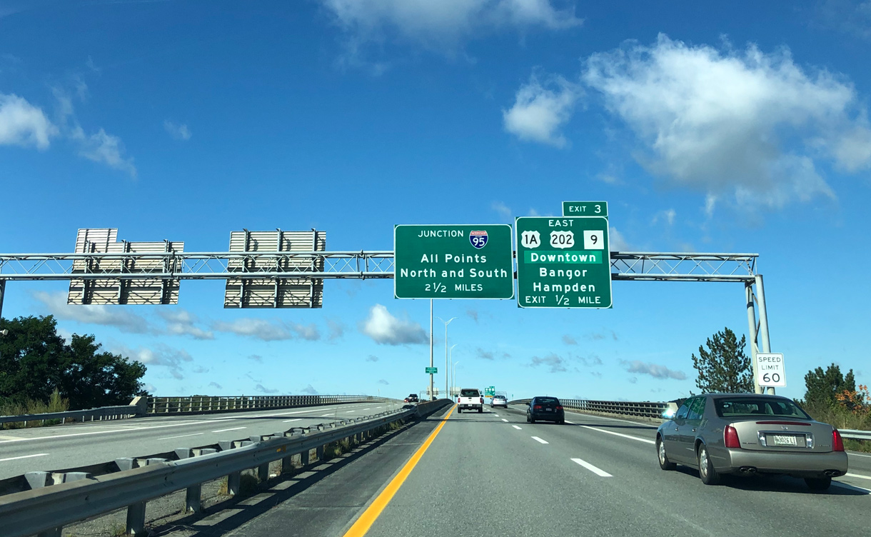
I-395 crosses the Penobscot River between Exit 4 to SR 15 (S Main Street) in Brewer and Exit 3 for U.S. 202 south, U.S. 1A and SR 9 (Main Street) in Bangor. Photo by Peter Johnson (09/27/19).

Two miles east of the exchange with I-95 on I-395 west at Exit 3. Exit 3 serves Downtown Bangor and East Hampden via U.S. 1A and SR 9 (Main Street). U.S. 202 begins in Bangor and travels south along Main Street to I-395. Photo by Peter Johnson (09/27/19).

Interstate 395 westbound at the trumpet interchange (Exit 2) with U.S. 202 south to Hampden. Photo by Peter Johnson (09/27/19).

Interests to Bangor International Airport (BGR) and SR 15 (Broadway) north to Dover-Foxcroft are directed onto I-95 north from forthcoming Exit 1B. Photo by Ian Ligget (04/15/16).

Exit 1B departs I-395 west for Interstate 95 and SR 15 north to Bangor International Airport (BGR) and Orono. Photo by Peter Johnson (09/27/19).

Orono, home to the University of Maine, lies ten miles to the north. Exit 184 with SR 222 (Union Street) leads to the airport terminal. Photo by Peter Johnson (09/27/19).

A loop ramp (Exit 1A) departs for I-95 south from Interstate 395 west. Interstate 95 turns west from Bangor 32 miles to Pittsfield and south 51 miles to Waterville. Motorists continuing west default into the intersection with U.S. 2 and SR 100. Photo by Ian Ligget (04/15/16).

End Interstate 395 shield posted beyond the cloverleaf interchange with I-95. Photo by Ian Ligget (02/23/16).

U.S. 2 and SR 100 turn west from Odlin Road and Bangor onto Hammond Street toward Hermon Center. The pair continue along the Interstate 95 corridor to their split at Newport. Photo by Ian Ligget (04/15/16).
![]()
![]() West at
West at ![]()

U.S. 2 and SR 100 (Hammond Street) east approach the busy intersection with Odlin Road and Interstate 395 east. Photo by Ian Ligget (04/15/16).

Odlin Road ties into the freeway beginning from Cold Brook Road and Ammo Industrial Park to the south. U.S. 2 and SR 100 eastbound turn onto Odlin Road north to rejoin Hammond Street at I-95 (Exit 183) to the left. Photo by Ian Ligget (04/15/16).
![]() East at
East at ![]()
![]()

Exit 1A quickly departs Interstate 395 eastbound for I-95 south to Newport, Waterville, Augusta and Portland. Photo by Ian Ligget (04/15/16).

A loop ramp (Exit 1B) follows for I-95/SR 15 north. SR 15 follows I-95 north from Exits 182 to 185 (Broadway), and I-395 from Exit 1 to Exit 4 to bypass Downtown Bangor. Photo by Ian Ligget (04/15/16).
![]() North at
North at ![]()
![]()

A mixture of shields accompany Interstate 395 on Exit 182 guide signs along I-95 north. I-395 provides connections to U.S. 2 and SR 100 (Odlin Road / Hammond Street) to the west and U.S. 1A and SR 9 to the east. Photo by Ian Ligget (04/15/16).

Exit 182A provides a direct route to U.S. 1A (Main Road) east from Brewer via I-395. U.S. 1A travels southeast 28 miles from Bangor to Ellsworth and U.S. 1. Ellsworth is the gateway to Acadia National Park and Bar Harbor.
Calais lies along U.S. 1 at the St. Croix River across from St. Stephen, New Brunswick. Photo by Ian Ligget (04/15/16).

Interstate 95 northbound at the ramp departure (Exit 182A) for I-395 east / SR 15 south. Exit 182B loops onto Interstate 395 west ahead of the intersection with U.S. 2 and SR 100. SR 9 meets the freeway at Exit 3 south of Downtown Bangor. The state route travels east from Brewer 90 miles to U.S. 1 at a point seven miles west of Calais. Photo by Ian Ligget (04/15/16).
![]()
![]() South at
South at ![]()
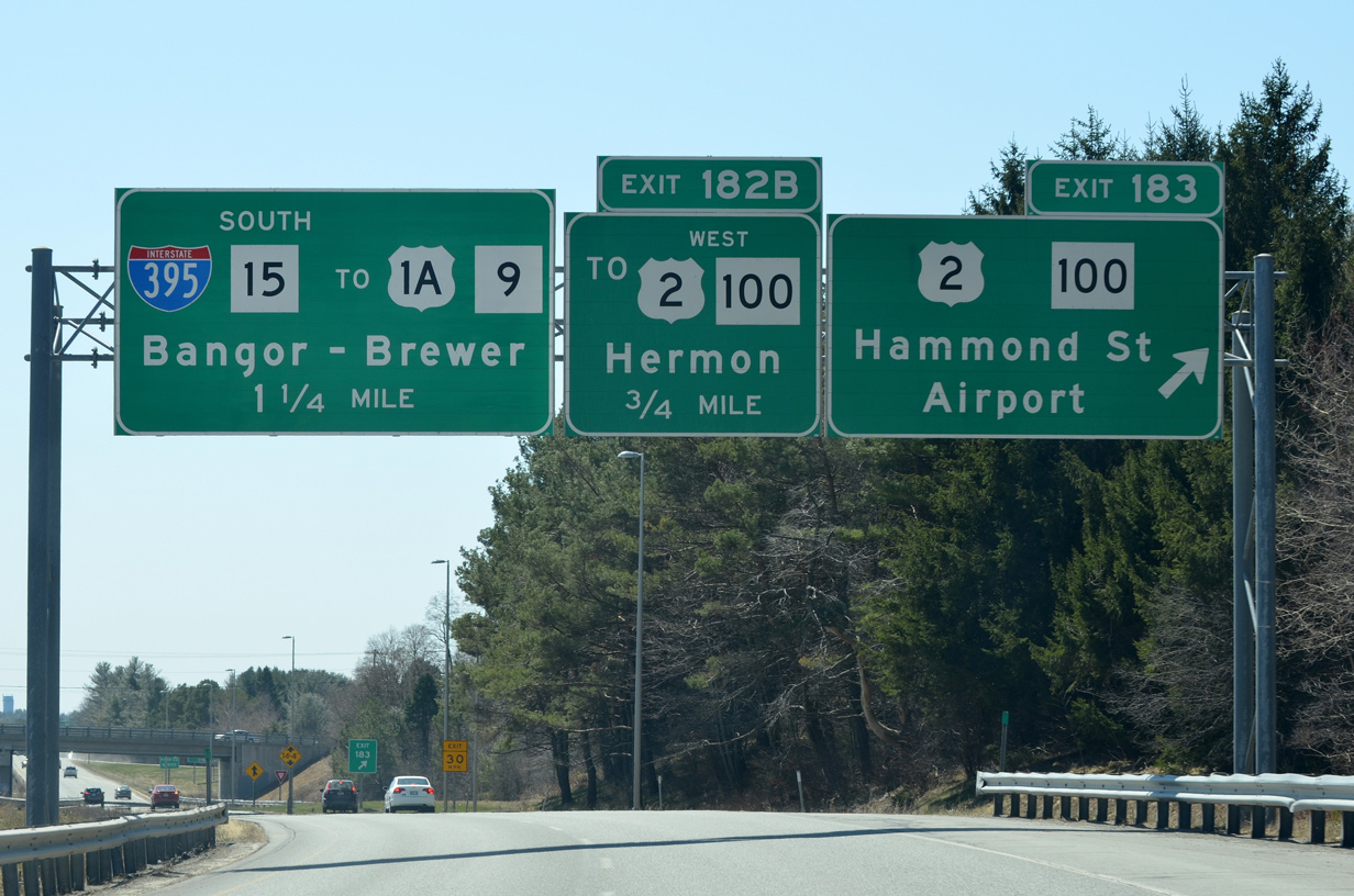
1.25 miles ahead of Interstate 395 (Bangor Industrial Spur) on I-95 south at Exit 183 for U.S. 2/SR 100 (Hammond Street). Photo by Ian Ligget (04/15/16).

U.S. 1A loops north from U.S. 1 at Stockton Springs and Ellsworth to connect Bangor and Interstate 395 with the Downeast & Acadia Region. Photo by Ian Ligget (04/15/16).

Entering the full cloverleaf interchange (Exits 182B/A) with Interstate 395 on I-95 south. The west end of I-395 serves U.S. 2 and SR 100 (Hammond Street) and a series of industrial parks at West Bangor. Photo by Ian Ligget (04/15/16).

SR 15 south combines with I-395 east to South Brewer. Connections with U.S. 1A and SR 9 provide part of a truck bypass of Bangor and Brewer for motorists heading to the Canadian Maritimes. Photo by Ian Ligget (04/15/16).
Sources:
- I-395/Route 9 Transportation Study – Overview,
http://www.i395-rt9-study.com/overview.htmlformer project web site. Accessed April 14, 2016. - “‘Hanging over us’: Homeowners face uncertainty as I-395 plan ramps up.” Bangor Daily News, April 13, 2016.
- “Wilson Street Bridge Replacement Project Beginning in Brewer.” Maine Department of Transportation (MaineDOT), news release. August 14, 2020.
- Maine’s Interstate System: An Investment in Safety, Mobility, and Prosperity by Maine Department of Transportation.
http://www.state.me.us/mdot/interstate/index.php
Page updated March 29, 2022.