Interstate 190 New York

Overview
Traveling northwest from Buffalo to Grand Island, Niagara Falls and Lewiston, Interstate 190 is the Niagara Section of the New York Thruway. This is one of three Interstate highway branches to end at an international boundary. The others are I-110 in El Paso, Texas, which links I-10 with the Bridge of the Americas into Ciudad Juárez, Mexico and I-69W to the World Trade Bridge at Laredo, Texas.
Interstate 190 is an urban freeway through Buffalo, passing south of Downtown along an elevated roadway. Tolls are charged along the South Grand Island Bridge northbound and the North Grand Island Bridge southbound over the Niagara River. The two spans link Tonawanda and Niagara Falls with Grand Island.
 History
Maps with suggested route numbers for the statewide urban Interstate numerology sent to the American Association of State Highway Officials (AASHO) on August 22, 1958 by the State Public Works Department designated Interstate 90N for the Niagara Section of the New York Thruway. I-190 was assigned to the loop around the north side of Buffalo. AASHO recommended changing I-190 to I-290 along Youngmann Expressway on August 29, 1958 but left I-90N unchanged.
These plans were announced for the New York interstate highway system numbering plan announced by the State Public Works Department on October 21, 1958.1 Following correspondence between AASHO and New York on December 4, 1958 and February 5, 1959, a proposal arose to change the numbering of the Interstate spur from Buffalo to Niagara Falls from I-90N to I-190. The Department of Public Works concurred on February 19, 1959:
The original number for this Canadian connection was 90-N, as recommended by the AASHO route numbering committee. The suggestion to change this number to 190 is excellent, and we will change our maps to comply with this new designation.
AASHO formally approved Interstate 190 on February 24, 1959.
Two sections of I-190 were completed on July 30, 1959. The 5.7 mile long portion leading west from I-90 (NY Thruway) to Porter Avenue in Buffalo opened with the exception of two Downtown access ramps. Also completed was a 1.5 mile segment from Sheridan Drive (NY 342) to the South Grand Bridge.2 The last 5.7 miles of I-190 opened for northbound traffic on September 1, 1960. The southbound roadway remained closed until Summer 1961 due to construction of the Scajaquada Creek Expressway (NY 198).3
Known as the Niagara Section of the New York Thruway, Interstate 190 originally had toll barriers at four locations: west of Interstate 90, south of the Peace Bridge, and at the two Niagara River crossings. The bridge crossings have tolls that are levied on inbound traffic only. During the 1950s and 1960s, when the New York Thruway was established, all the exits on the “Niagara Section” were numbered with the prefix of N-xx. This practice was done to distinguish them from the Thruway mainline exit numbering system.4
Route Information
North End – Lewiston, NY
- South End – I-190 south at I-90 – Cheektowaga, NY
Mileage – 28.34
Cities – Buffalo, Niagara Falls
- Junctions –


Source: December 31, 2021 Interstate Route Log and Finders List
I-190 Annual Average Daily Traffic (AADT)
Source: 2015 NYSDOT Traffic Data Viewer
The Niagara Section of the Thruway initially extended northwest from Buffalo to Grand Island and NY 384 (Buffalo Avenue) in Niagara Falls.
Erie County Clerk David J. Swarts presented a petition of about 20,000 signatures to regional transportation officials advocating the removal of the Interstate 190 toll plazas within the city of Buffalo. The contention was that Buffalo is the only upstate city in New York that had tolls levied on its commuters. He cited the differences between Buffalo and Rochester as a justification for the toll removal.
A similar concern arose in the early 2000s from Grand Island commuters concerning the tolled Niagara River spans of Interstate 190. These residents were somewhat successful in their complaints in that they were granted special commuter rates for returning to the island via the Grand Island bridges.5
Efforts to remove the two Buffalo toll plazas were also successful. Tolls along Interstate 190 in Buffalo ceased on October 30, 2006 by order of the New York Thruway Authority.6

The southbound crossing of the South Grand Island Bridge along Interstate 190 dates back to 1935. 08/23/21

The northbound span of the South Grand Island Bridge was completed in 1963. The steel through arch bridge spans the Niagara River northwest from Tonawanda. 08/22/21
 Photo Guides
North End – Canadian International Border – Lewiston, New York
![]() North at
North at ![]()
Interstate 190 curves northwest through a three quarter cloverleaf interchange (Exit 25) with Upper Mountain Road preceding the customs station for the Lewiston-Queenston Bridge into Ontario, Canada. 08/23/21

Exit 25 A departs for NY 265 (Military Road), a parallel route alongside Niagara Power Reservoir heading north from Niagara Falls to Lewiston. 08/23/21

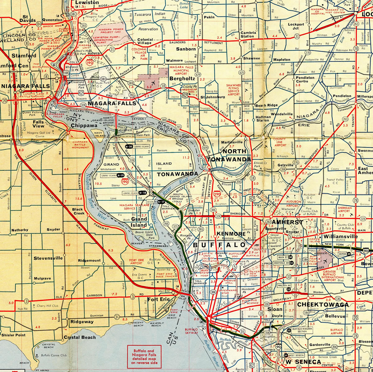
Exit 25 B represents the last departure point ahead of the port of entry for King’s Highway 405 and Saint Catherines, Ontario on I-190 northbound. A loop ramp joins Upper Mountain Road west ahead of ramps for NY 104 (Lewiston Road) and Niagara Scenic Parkway. 08/23/21
Upper Mountain Road – East at ![]()

Upper Mountain Road (NY 954P) stems east from a half cloverleaf interchange with NY 104 (Lewiston Road) to meet Interstate 190 just beyond the customs station for the Lewiston-Queenston Bridge. 08/23/21

Interstate 190 travels south from the Lewiston area around Niagara Falls en route to Grand Island and Buffalo. 08/23/21
Upper Mountain Road – West at ![]()

Upper Mountain Road enters the cloverleaf interchange with Interstate 190 just beyond NY 265 (Military Road) and CR 5. A loop ramp joins I-190 south to Niagara Falls after the entrance ramp for the Lewiston-Queenston Bridge to St. Catharines, Canada. 08/23/21
South End  – I-190 south at I-90 – Cheektowaga, New York
![]() South at
South at ![]()

The last mainline exit from I-190 connects with Griswold and Cochrane Streets along the Buffalo city line east of S Ogden Street. Three lanes continue east to Interstate 90 (New York Thruway). 08/23/21

A second diagrammatic sign precedes the separation of Interstate 190 south into the ramps for I-90 west to Erie, Pennsylvania and east to Buffalo Niagara International Airport (BUF). 08/23/21

Although still a part of the Thruway mainline, I-90 through Buffalo is toll free between Exit 50 / I-290 near Williamsville and Exit 55 / U.S. 219 (Exit 55) to the south in the town of West Seneca. 08/23/21
![]() West at
West at ![]()

Exit 52 A leaves I-90 (New York Thruway) west for William Street in Cheektowaga, 1.5 miles ahead of I-190 (Niagara Section of the New York Thruway). 08/23/21

Connecting the city with Niagara Falls and the Lewiston-Queenston Bridge to King’s Highway 405, Interstate 190 encircles Downtown Buffalo to the west. 08/23/21

Interstate 190 branches west from I-90 in a half mile to Downtown Buffalo and the Rainbow Bridge into Fort Erie, Ontario. 08/23/21

Westbound Interstate 90 (New York Thruway) continues with three lanes toward toward Erie, Pennsylvania, and Cleveland, Ohio beyond Exit 51 / I-190 (Niagara Section of the New York Thruway). 08/23/21
![]() East at
East at ![]()

I-90 heads north from the end of NY 400 in the town of West Seneca to Interstate 190. Photo by Douglas Kerr (09/03/12).
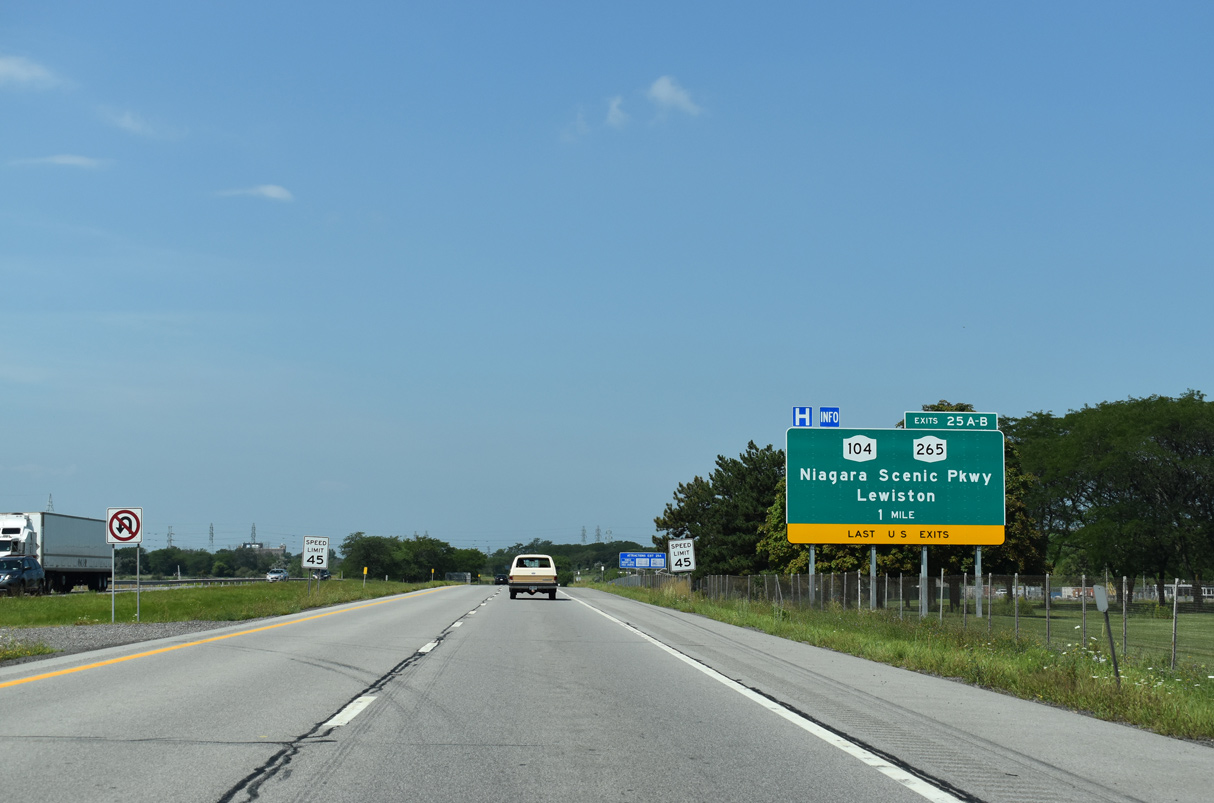
A half mile ahead of the three level interchange (Exit 53) with Interstate 190 on I-90 (New York State Thruway) eastbound. Photo by Douglas Kerr (09/03/12).

Four additional exits link the toll free portion of the NYS Thruway with the Buffalo area beyond I-190 north to Downtown. Photo by Douglas Kerr (09/03/12).
Sources:
- “Kingston Arterial Route Will Bear Numbers 587.” The Kingston Daily Freeman (NY), October 21, 1958.
- “Thruway Reaches Heart of Buffalo.” Wellsville Daily Reporter (NY), July 30, 1959.
- “Thruway Niagara Section to Open.” The Kingston Daily Freeman (NY), September 1, 1960.
- Cuff, Richard. “Thruway Exit Numbering (was: Re: [northeastroads] Re: Who else out there hates I-99).” Online posting, Yahoo! Groups Northeastern U.S. Roads, November 20, 2003.
- “Petition supports case for removing toll barriers.” Buffalo News, November 11, 2003.
- AARoads Wiki. (2026, March 31). Interstate 190 (New York). AARoads Wiki. Retrieved July 17, 2026, from https://wiki.aaroads.com/wiki/Interstate_190_(New_York)
Page updated April 11, 2023.