Interstate 840 North Carolina

Overview
Located within the Triad region in north-central North Carolina, Interstate 840 follows the Greensboro Urban Loop from I-40 and I-73 by Piedmont Triad International Airport (PTI) to the west and the exchange joining I-40, I-85 and I-785 near Stewarts Mill to the east. I-840 accompanies Interstate 785 along the Greensboro Urban Loop for 7.65 miles south from U.S. 29 to I-40/85.
Interstate 85 comprises the southeastern quadrant of the Greensboro Urban Loop. The 13 mile long section opened to traffic in February 2004.1 Completed by February 2008, the southwest leg of the Greensboro Urban Loop is a part of Interstate 73.
Project U-2525C, the final section constructed along the Greensboro Northern Loop, extended 4.7 miles east from Lawndale Drive to U.S. 29. Work commenced on the $137.7 million project in April 2018. A two mile portion opened between Lawndale Drive and N Elm Street nearly a year ahead of schedule on December 23, 2020.8 The remainder of the six lane freeway opened to traffic on January 23, 2023. Completion of overall work was expected by Spring 2023,1 and actually was in January 2023.
The American Association of State Highway and Transportation Officials (AASHTO) approved the final 7.28 miles of Interstate 840 as a logical addition to the Interstate System at the October 2022 meeting.
 History
The 44 mile long Greensboro Urban Loop originated in a late 1940s transportation plan to add a parkway encircling the city. It was later named Painter Boulevard, after a former city manager.7 The initial section of Interstate 840 completed was the two mile segment north from I-40 and I-85 to U.S. 70. Located east of Greensboro and initially signed as Future I-840, the segment opened to traffic in 2002.
Subsequent construction for Interstate 840, between I-40 west of Greensboro and Joseph Bryan Boulevard, was underway during the week of September 8, 2003. The $101.6 million project was expected to open to traffic by Summer 2007, but was delayed until February 21, 2008. Citing potential benefits to Piedmont Triad International Airport (PTI) area traffic congestion, this leg of the Greensboro Urban Loop was prioritized by state officials.2 Upon completion, the west leg of the loop was dually signed as Future I-73 and I-840.
The American Association of State Highway and Transportation Officials (AASHTO) Special Committee on U.S. Route Numbering conditionally approved two additional segments of I-840 at their September 2017 meeting: one extending from its split with I-73 and Bryan Boulevard to U.S. 220 in northwest Greensboro, and the other continuing northward from U.S. 70 on the east side of the loop to U.S. 29.3
Work on the northern half of the beltway continued with construction underway in October 2013 on project U-2524C. Costing $123 million, work extended I-840 northeast from Bryan Boulevard (I-73) to U.S. 220 (Battleground). A dedication ceremony took place for the 3.8 mile, six lane wide freeway on April 13, 2018. It opened to motorists on April 19, 2018.4

The future roadways for Interstate 840 at Joseph Bryan Boulevard. This section opened to traffic on December 6, 2017. 12/15/16
Route Information
East End – Greensboro, NC
West End – Greensboro, NC
Mileage – 21.69
Cities – Greensboro
- Junctions –


Source: January 7, 2025 NCDOT State Maintained Roads – Primary Routes
I-840 Annual Average Daily Traffic (AADT)
| Location | Vehicles per day |
|---|---|
| Exits 103 (I-40) to 104 | 69,000 |
| Exits 104 to 107 | 51,500 |
| I-73 to Exit 6 (US 220) | 15,500 |
Source: 2023 NCDOT AADT Mapping Application

The Greensboro beltway carries U.S. 421, I-73 and I-85 along the southern half. I-73/840 overlap north to Bryan Boulevard. I-785 accompanies the east leg of the loop to connect with U.S. 29 north toward Reidsville.

Interstate 840 north at U.S. 70 and the temporary freeway end east of Greensboro. The freeway opened north from here to U.S. 29 on April 19, 2018. 12/15/16
Project U-2424B added the next four lane section of the eastern loop. Started in August 2014, $140 million in construction lengthened I-785/840 northward from U.S. 70 to U.S. 29 in northeast Greensboro. The 5.5 mile segment opened to traffic a year a head of schedule on December 7, 2017.1 30,000 vehicles per day (vpd) were projected on this section of I-785/840, with forecast traffic rising to 58,000 vpd by 2040.5
With work progressing ahead of schedule,6 the succeeding sections of the Greensboro Northern Loop extended east from U.S. 220 (Battleground Road) to N Elm Street. Work on Project U-2524D, the 1.9 mile long link from U.S. 220 (Battleground Road) east to Lawndale Drive started in November 2016.1 Costing $67 million, this section was anticipated for completion in September 2019,7 and eventually opened to traffic on December 30, 2019. The penultimate section lengthened Future I-840 another two miles east from Lawndale Drive to N Elm Street.
 Photo Guides
East End 
 – Greensboro, North Carolina
![]() East at
East at ![]()
![]()

Signs installed in 2017 added Interstate 785 for Exit 227, where I-40 east meets both I-85 south back toward High Point and I-840 north to U.S. 70. 12/31/23

Interstate 840 was added on signs for Exit 227 in 2023. 12/31/23
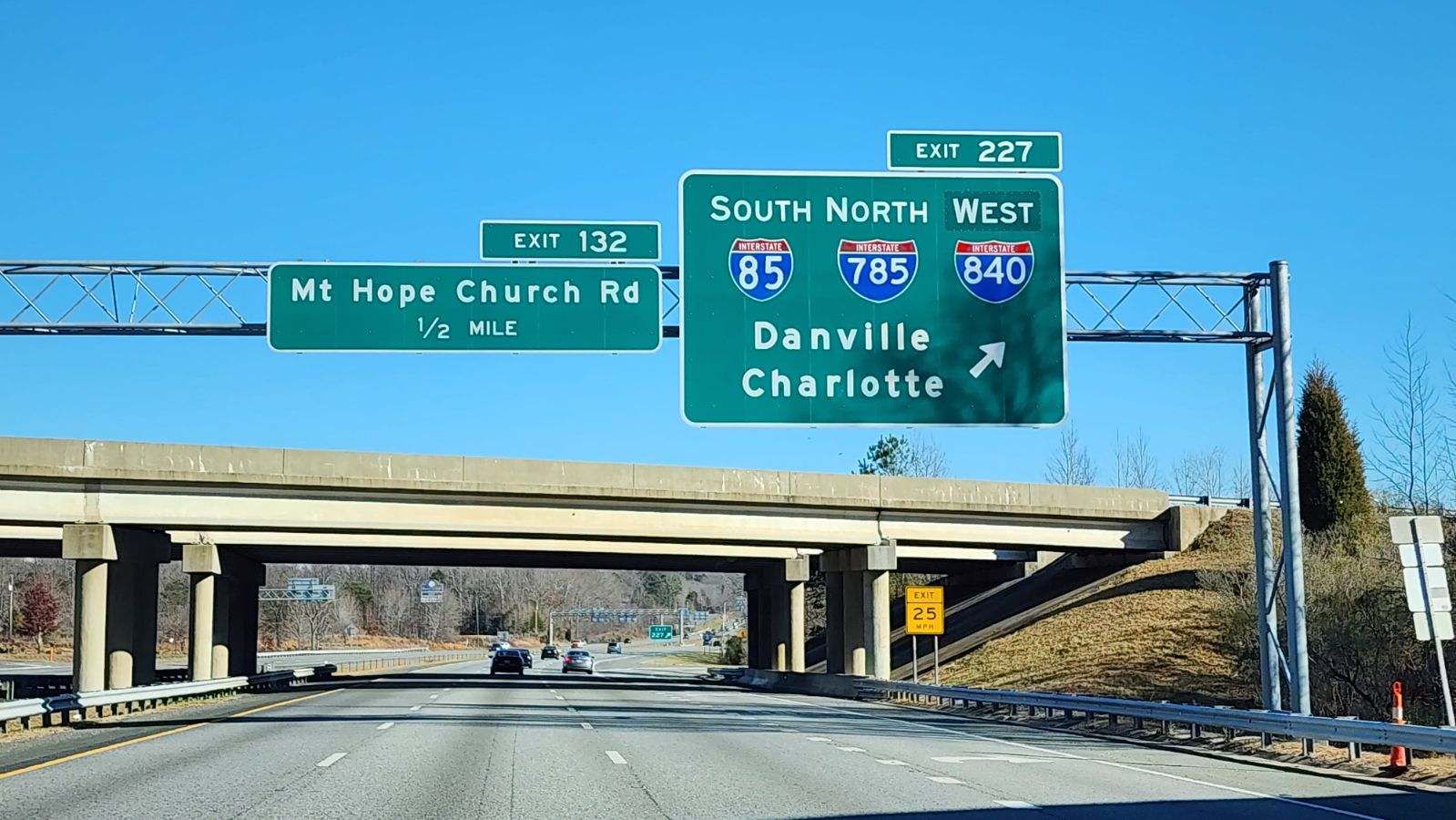
I-785/840 overlap 7.65 miles north from I-40 to U.S. 29. The U.S. 29 corridor doubles as Future I-785 northeast from the Greensboro Northern Loop to Danville, Virginia. 12/31/23
![]() South
South ![]() East at
East at ![]()
![]()

I-785/840 shift east beyond the Clapp Farms Road (SR 3041) overpass to the directional cloverleaf interchange (Exit 21) with I-40/85. 10/12/23

An end sign was added along the Greensboro Urban Loop for I-840/785 following the completion of the beltway in 2023. 10/12/23

Exit 21 departs I-785/840 east for I-40 west into Greensboro and east with I-85 north to Burlington. A wye interchange follows, taking Interstate 785 onto I-85 south toward High Point. 10/12/23
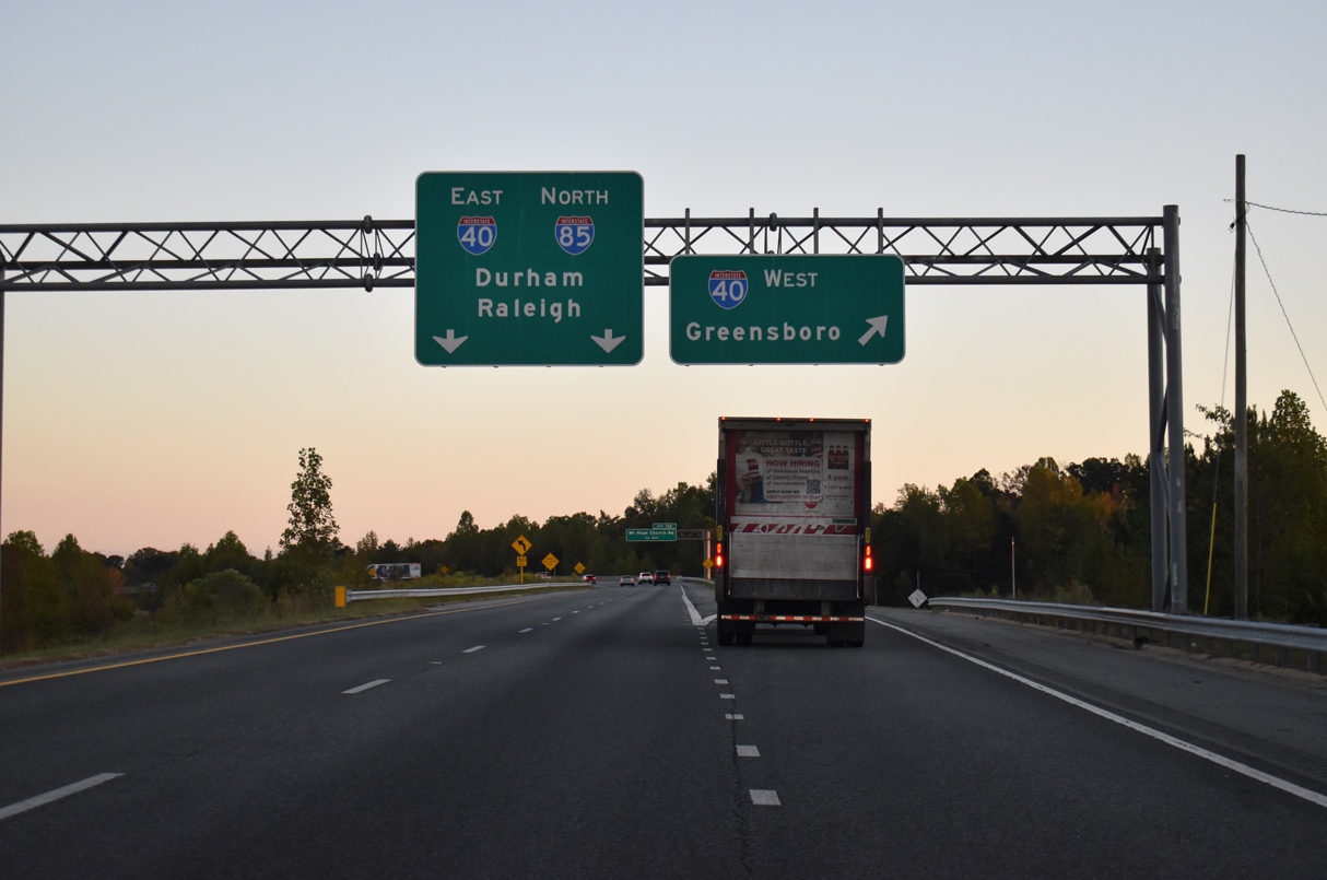
Exit 21 partitions for I-40 west toward Downtown Greensboro and I-40/85 east to Durham and Raleigh. 10/12/23
![]() North at
North at ![]()
![]()

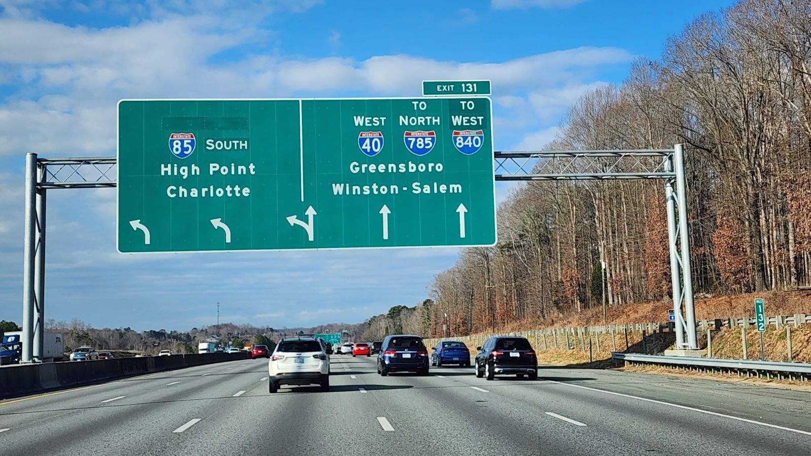
Interstate 85 curves northeast from Youngs Mill Road to the wye interchange (Exit 131) with I-785 north / I-840 west. 05/31/21

I-785/840 overlap 7.65 miles north from I-85 to U.S. 29 near Summit Hills in northeastern Greensboro. 05/31/21

I-785/840 separate from I-85 northbound ahead of a directional cloverleaf interchange (Exit 21) with Interstate 40 west across Greensboro. 05/31/21
![]() West
West ![]() South at
South at ![]()
![]()

I-40/85 head one mile west from the parclo interchange (Exit 132) at Mt. Hope Church Road (SR 3045) to the exchange with I-785 north / I-840 west. 12/30/23
I-40/85 enter the Greensboro city limits west ahead of their separation at I-785/840. 12/30/23

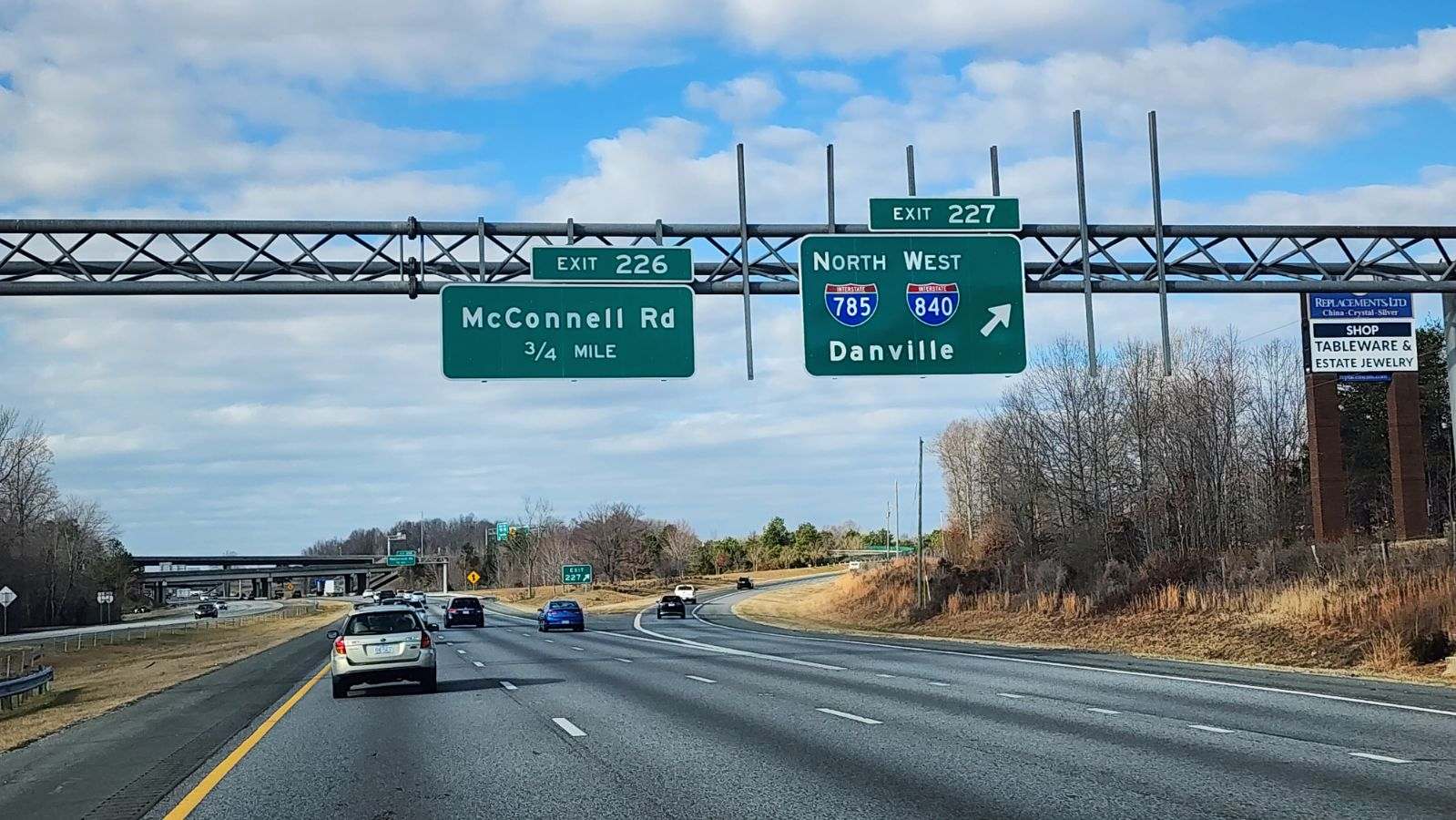
I-85 follows the southeastern quadrant of the Greensboro Urban Loop to I-73. I-73 runs along the southwestern section to I-40 and the west end of I-840. 12/30/23

I-785/840 connects I-40/85 west with U.S. 70 (Burlington Road) in east Greensboro. 12/30/23
I-785 and U.S. 29 extend 39.6 miles northeast from Interstate 40 to the Danville Expressway along U.S. 58. 12/30/23
West End  – Guilford, Greensboro, North Carolina
![]() South
South ![]() West at
West at ![]()
![]()

I-73/840 proceed 1.5 miles south from the SPUI (Exit 104) with W Friendly Avenue to the cloverstack interchange (Exit 103) with I-40/U.S. 421. 05/31/21

I-73/840 pass over Market Street (old U.S. 421) ahead of the two lane exit for I-40/US. 421 west to Winston-Salem and I-40 east to central Greensboro. 05/31/21

Two lanes continue south along I-73 from the end of Interstate 840 toward High Point, south Greensboro and Asheboro. 05/31/21
![]()
![]() North at
North at ![]()
![]()

I-73/U.S. 421 north at the systems interchange (Exit 103) with I-40 east to Greensboro and I-40 west to Winston-Salem. 07/28/24

U.S. 421 turns west alongside I-40 toward Winston-Salem while I-73 north combines with the beginning of I-840 north at I-40. 07/28/24
![]() East
East ![]() South at
South at ![]()
![]()

Traffic partitions along Interstate 40 east for I-73/U.S. 421 south at Left Exit 212 A ahead of the cloverstack interchange with I-73/840 east. 08/15/21

The three lane continuation onto I-73/U.S 421 south is a remnant from the 2008 plan to reroute I-40 along the southern half of the Greensboro Loop. 05/31/21

U.S. 421 follows the Greensboro Urban Loop southeast along I-73 and I-85 to the Future I-685 corridor linking Greensboro with Sanford. 05/31/21

The succeeding ramp from I-40 east is for I-73/840 north to Piedmont Triad International Airport (PTI). 08/15/21

I-73/840 overlap 3.63 miles north from Exit 212 B to Joseph M. Bryan Boulevard (SR 2085). 08/15/21

Interstate 73 branches west from I-840 (Greensboro Urban Loop) en route to PTI Airport and Rockingham County. 05/31/21
![]() West
West ![]() North at
North at ![]()
![]()

I-40 meet Guilford College Road at Exit 213, 0.75 miles from the cloverstack interchange with I-73, I-840 east and U.S. 421 south. 08/14/21

An auxiliary lane opens along I-40 westbound from Guilford College Road (SR 1546) to Exit 212 B for I-73/840 north to Piedmont Triad International Airport (PTI). 08/23/21

U.S. 421 accompanies I-40 west from I-73/840 to Salem Parkway through Winston-Salem. U.S. 421 south overlaps with I-73 from I-840 to I-85 and the Future I-685 corridor. 08/23/21
Interstate 40 west leading to I-73 and I-840 east. 08/14/21
Sources:
- “Western section of Urban Loop slated to open next.” News & Record (Greensboro, NC), December 8, 2017.
- “Work to begin this week on new section of Greensboro loop.” News & Record (Greensboro, NC), September 10, 2003.
- AASHTO Special Committee on U.S. Route Numbering Meeting Minutes, September 24, 2017.
- “New section of Urban Loop in Greensboro open for traffic.” News & Record (Greensboro, NC), April 19, 2018.
- Eastern Section of Greensboro Urban Loop Now Open. (2017, December 6). WFMY News 2. https://www.wfmynews2.com/article/news/traffic/eastern-section-of-greensboro-urban-loop-now-open/83-497486255
- Greensboro Urban Loop Work Moving Faster Than Expected. (2018, October 18). WFMY News 2. https://www.wfmynews2.com/article/traffic/greensboro-urban-loop-work-moving-faster-than-expected/83-605727658
- Urban Loop becoming reality for some, looming for others in Greensboro. (2018, December 22). News & Record.
- North Carolina Department of Transportation. (2020, December 23). Next-To-Last Section of Greensboro Urban Loop Opens. [Press release]. https://www.ncdot.gov/news/press-releases/Pages/2020/2020-12-23-greensboro-urban-loop-section-opens.aspx”
Page updated January 5, 2026