Interstate 244 Oklahoma

Overview
Commonly called the Crosstown Expressway,1 Interstate 244 loops north to central Tulsa while I-44 (Skelly Drive) bypasses to the southeast. The freeway connects with a number of radial routes leading outward from Tulsa, including the Sand Springs Expressway west, Tisdale Parkway north, Cherokee Expressway northeast and Broken Arrow Expressway southeast. Shared alignments bring U.S. 75 north from Jenks and U.S. 412 west from Catoosa in addition to U.S. 64/SH 51 at Downtown.
I-244 is the Red Fork Expressway from I-44 northeast to Downtown and the MLK Expressway from Downtown east to I-44.1 I-244 also represents the western and northern leg of the Inner Dispersal Loop (IDL) freeway system encircling Downtown Tulsa. Unsigned Interstate 444 comprises the south and east legs of the urban loop alongside U.S. 64, U.S. 75 and SH 51.
 History
The final section of Interstate 244 completed through Tulsa was the north leg of the Inner Dispersal Loop in December 1975.2 It was named the Martin Luther King Jr. Expressway east from Downtown by the Oklahoma Highway Commission in 1984.1
The spans carrying I-244/U.S. 75 across the Arkansas River to Downtown Tulsa were built in 1967. With money partially funded by a nearly $50 million TIGER (Transportation Investment Generating Economic Recovery) Grant in February 2010, a $78 million project commenced in April 2011 to replace the functionally obsolete westbound bridge.3 The span closed with all traffic shifted to the eastbound span with two-way traffic by June 14, 2011.4 Crews then demolished the existing span to make way for a new double deck structure with three highway lanes on the upper level and two dedicated future rail lines and a multi use path on the lower level.3
The new 3,300 foot long westbound bridge across the Arkansas River opened to traffic on December 19, 2012.5 Residual work there continued to 88 percent completion by March 4, 2013, when the Oklahoma Department of Transportation (ODOT) approved a $41 million contract for the replacement of the eastbound span. The single level bridge was designed with an observation deck overlooking Cyrus Avery Plaza and the historic 11th Street Bridge.6
Work started on the new eastbound bridge on June 7, 2013, with construction of temporary crossovers to shift traffic onto the westbound span and repairs underway on the south leg of the IDL.7 A ribbon cutting ceremony took place on September 15, 2014 for the completion of the span. Ensuing work focused on the trails underneath the bridge and the viewing platform through Spring 2015. This work ran in tandem with the reopening of the IDL south leg.8
Construction rebuilt a five mile section of Interstate 244 (MLK Expressway) starting with the section between Delaware Avenue and 73rd E Avenue on March 2, 2015. The $38 million project followed 2014 reconstruction of I-244 east from near Memorial Highway to I-44.9 It coincided with a $22 million contract (awarded February 2015) for the western portion of the construction zone, from U.S. 75 (Cherokee Expressway) and the IDL east to Delaware Avenue. The freeway was resurfaced with concrete by October 2015 while work to replace overpasses at 73rd E, Delaware and Peoria Avenues and Admiral Place advanced to Summer 2016.10
$9.4 million in construction started on July 17, 2017 replaced the overpasses built in 1967 for Memorial Drive by the SH 11 interchange, and Harvard, Pittsburg and Yale Avenues further west along I-244. The bridge work ran through Summer 2018.11 $5.8 million in construction at the west end of Interstate 244 through early 2018 rehabilitated bridges at the exchange with I-44 and the 51st Street connector.12
Route Information
East End – Tulsa, OK
West End – Oakhurst, OK
Mileage – 15.75
Cities – Tulsa
- Junctions –


Source: December 31, 2021 Interstate Route Log and Finders List

Interstate 244 replaced the entire loop of Oklahoma State Highway 33 through Tulsa.

Interstate 244 under construction along the Crosstown Expressway from Utica Avenue east to I-44. The Red Fork Expressway portion of I-244 and the Inner Dispersal Loop (IDL) remained unconstructed in 1968.

The Sequoyah Loop was proposed as an outer loop around the north and west sides of Interstate 244. The Gilcrease Drive section opened east from Tisdale Parkway eventually as SH 11, while the portion of the route north from I-244 to the Sand Springs Expressway (U.S. 64/SH 51) will be completed by the Oklahoma Turnpike Authority.
East End 

 – eastern Tulsa, Oklahoma
![]()
![]() East at
East at ![]()
![]()

A half diamond interchange (Exit 15) provides eastbound access from I-244/U.S. 412 to 129th E Avenue ahead of the wye interchange with I-44/SH 66. 11/01/16

I-244/U.S. 412 curve southeast from 129th E Avenue to merge onto I-44/SH 66. No signs are posted for the transition. 05/05/12
![]()
![]()
![]() West at
West at ![]()

I-244/U.S. 412 split from I-44/SH 66 west to Tulsa International Airport (TUL) and the Osage Nation at a wye interchange (Exit 236B) in two and a half miles. 11/02/16

A $31 million project started in January 2017 replaced the 145th Avenue E overpass across I-44 and expands the freeway to six lanes from the 161st E Avenue entrance ramp west to the split with U.S. 412 and I-244. This scene changed by Spring 2017 with all traffic shifted onto the eastbound roadway.12 11/02/16
I-244/U.S. 412 (Martin Luther King, Jr. Expressway) lead west nine miles directly to Downtown Tulsa. The two separate on the northwest side of the Inner Dispersal Loop (IDL) at U.S. 64/SH 51 (Sand Springs Expressway). 11/02/16
![]()
![]() East at
East at ![]()
![]()

The eastbound lanes of I-244/U.S. 412 cross over I-44/SH 66 east as a lane drop occurs. U.S. 412 combines with I-44 east for 4.3 miles to the end of the Creek Turnpike, where I-44 turns north onto the Will Rogers Turnpike to Joplin, Missouri. Photo by Eric Stuve (11/28/02).
 East End Throwback

Button copy signs posted on the approach to Exit 236B for I-244 west on I-44/SH 66 west. I-244 replaced the parallel route of SH 33 and U.S. 75 along Admiral Place to Lewis Avenue in Tulsa. Photo by Eric Stuve (12/01/02).

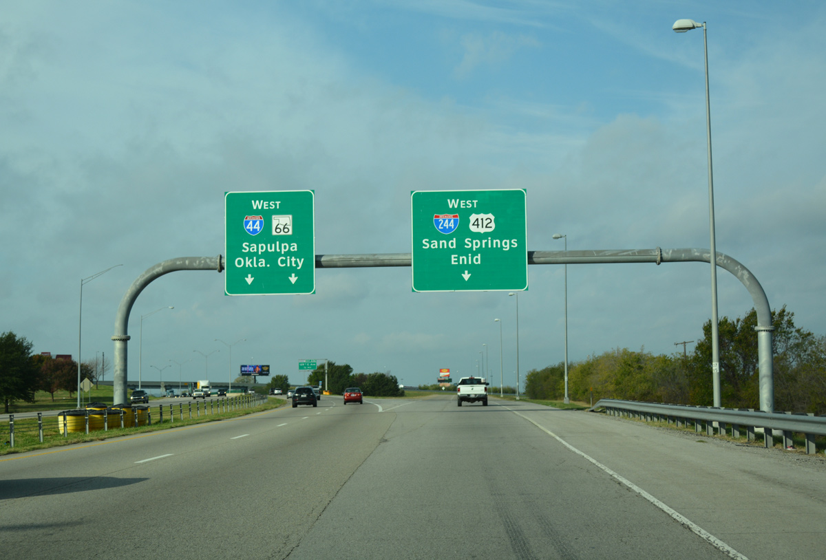
The control points for MLK Expressway include Sand Springs, a suburb of Tulsa along U.S. 64-412/SH 51 (Sand Springs Expressway) west, and Enid, a city beyond I-35 along U.S. 64/412. Including the lack of an exit tab, these signs were eventually replaced in kind with Clearview font. Photo by Eric Stuve (12/01/02).
West End / Gilcrease Expressway – Oakhurst, Oklahoma
![]() West at
West at ![]()
![]()

Interstate 244 and parallel Southwest Boulevard (old U.S. 66 Business, U.S. 75 Alternate and SH 33) come together south of Red Fork. Southwest Boulevard runs directly to the west of the Red Fork Expressway end at Exit 1A. 05/04/12

Entering the cloverstack interchange (Exit 1A) with I-44/SH 66 (Skelly Drive) east and the Gilcrease Expressway spur west on I-244 west. The freeway spur to 51st Street was constructed as part of the overall outer loop planned with SH 11 on the north side of Tulsa. 05/04/12

Exit 1A returns I-244 traffic to Tulsa via I-44/SH 66 east as the mainline defaults onto I-44/SH 66 west to Oakhurst and the Turner Turnpike. 05/04/12
![]()
![]() East at
East at ![]()

I-44 and SH 66 combine at the east end of the Turner Turnpike along a six lane freeway preceding Exit 223A for I-244 east. Two lanes join the Red Fork Expressway northeast to the Inner Dispersal Loop (IDL) around Downtown while I-44 turns east onto Skelly Drive. 05/04/12

Exit 223A departs from I-44/SH 66 east for Downtown Tulsa. I-244 reaches the central business district in five miles. I-44/SH 66 overlap across Tulsa to Catoosa (Exit 241) while Joplin lies 112 miles to the northeast. 05/04/12

The cloverstack interchange between I-44 and I-244 ties into the Gilcrease Expressway spur west to 51st Street. The spur travels at-grade from 51st Street north to 41st Street. 57th West Avenue extends north from there to W 21st Street near the Arkansas River. A $28 million Oklahoma Turnpikes project underway through Fall 2022 extends the Gilcrease Expressway north to U.S. 64/412 (Sand Springs Expressway). 05/04/12
![]()
![]() West at
West at ![]()

I-44/SH 66 pass over 33rd W Avenue just ahead of succeeding ramps for Interstate 244 east (Exit 223A) and the Gilcrease Expressway spur west (Exit 223B). 05/05/12

Exit 223A joins I-244 (Red Fork Expressway) leading northeast to Downtown Tulsa. The Gilcrease Expressway extends west from Skelly Drive to 51st Street and north to 41st Street. I-44/SH 66 turn southwest and split at Exit 221B ahead of the tolled Turner Turnpike. 05/05/12
West End Throwback

One half mile from Interstate 244 on I-44/SH 66 east at Exit 222B to 55th Place. The overhead for Exit 223A was replaced with a variable message board by 2007. Photo by Eric Stuve (12/01/02).

Older signs for the I-44/244 split referenced the Red Fork Expressway as the Martin Luther King, Jr. Expressway. The separation at Exit 223A remained unchanged through 2016. Photo by Eric Stuve (12/01/02).
Sources:
- “Tulsa World Stylebook – E.” Tulsa World (OK), April 15, 2015.
- “Phone Company Wires Crossed on 1-900 Billing.” Tulsa World (OK), July 18, 1990.
- “Groundbreaking ceremony launches I-244/Arkansas River bridge replacement project in Tulsa.” ODOT News, press release. April 15, 2011.
- “Westbound I-244 bridge coming down.” Tulsa World (OK), June 14, 2011.
- “New I-244 bridge awaits traffic tonight.” Tulsa World (OK), December 19, 2012.
- “Eastbound bridge up next.” Tulsa World (OK), March 5, 2013.
- “Next phase of I-244 river bridge to begin soon.” Tulsa World (OK), June 5, 2013.
- “I-244 bridge opens.” Tulsa World (OK), September 16, 2014.
- “Crews To Begin I-244 Rebuilding Project.” News On 6, March 2, 2015.
- Oklahoma Department of Transportation – I-244 project.
https://www.ok.gov/odot/I-244_project.html - “Starting Monday: 4 bridges over I-244 east of downtown to be replaced; work to last until next summer.” Tulsa World (OK), July 16, 2017.
- “From east to west, downtown and midtown, major projects affecting Tulsa traffic.” Tulsa World (OK), July 20, 2017.
Page updated August 22, 2017.