Interstate 194 Michigan

Overview
Interstate 194 spurs northward from B Drive and I-94 alongside M-66 to Downtown Battle Creek. M-66 ties into the south end of the freeway at a retail area anchored by Lakeview Square Mall. I-194 and M-66 run along the Emmett Township line from the exchange with I-94 to M-96 (Columbia Avenue). An S-curve takes the freeway across the Kalamazoo River to Business Loop I-94 along Dickman Road. M-66 extends north from the freeway end at Jackson Street / Hambin Avenue along the east side of Downtown.
 History
Part of the Interstate Urban Area Numerology for the state of Michigan submitted to the American Association of State Highway Officials (AASHO), the urban connector into Battle Creek was approved as I-194 on August 29, 1958. Interstate 194 opened to traffic fully by 1966. The two mile long section between Interstate 94 and Columbia Avenue (M-96), was designated in 1961.1
Route Information
North End – Battle Creek, MI
South End – Battle Creek, MI
Mileage – 3.40
Cities – Battle Creek
- Junctions –

Source: December 31, 2021 Interstate Route Log and Finders List
I-194 Annual Average Daily Traffic (AADT)
| Location | Vehicles per day |
|---|---|
| B Dr to Exit 1 | 31,584 |
| Exits 1 to 2 | 28,071 |
| Exits 2 to 3 | 23,041 |
| Exit 3 to Jackson St | 21,860 |
Source: 2017 AADT – Michigan Department of Transportation (MDOT) Traffic Volumes Map
 Photo Guides
North End  / Hamblin Ave – Battle Creek, Michigan
![]()
![]() North at Hamblin Avenue
North at Hamblin Avenue

I-194/M-66 elevate across Business Loop I-94 (Dickman Road), CN Railroad tracks and Fountain Street a half mile north to Hamblin Avenue. 11/05/11

Lowering to grade level, I-194/M-66 intersect Hamblin Avenue / Jackson Street southeast of Kellogg Arena and just east of Business Loop I-94 (Main Street). 11/05/11

An end sign for Interstate 194 stands at the turn off for Jackson Street to Business Loop I-94 along Michigan Avenue. M-66 (Division Street) extends north across Battle Creek to Capitol Avenue. 11/05/11
![]() South at
South at ![]()

M-66 (Division Street) south at Hamblin Avenue / Jackson Street and the beginning of Interstate 194. Photo by Don Hargraves (11/02).
South End – – Battle Creek, Michigan
![]()
![]() South at
South at ![]()

I-194/M-66 (Sojourner Truth Downtown Parkway) lead due south from the G Drive underpass to Exit 1 B/A for Interstate 94. 11/05/11

Undeveloped timberland lines the east side of Interstate 194 within Emmett Township. Several subdivisions in south Battle Creek appear to the west ahead of I-94. 11/05/11

An end marker for Interstate 194 appears north of Minges Brook and the ramp for I-94 west to Kalamazoo. 11/05/11

Interstate 94 travels 18 miles west from I-194/M-66 to Business Loop I-94 into Kalamazoo and 66 miles to I-196 outside Benton Harbor. 11/05/11

A loop ramp (Exit 1A) connects the south end of I-194 with Interstate 94 east to Marshall, Jackson and Ann Arbor. The freeway extends another half mile south along M-66 to Beckley Road / B Drive. 11/05/11
![]()
![]() North at
North at ![]()

Beckley Road intersects the south end of the M-66 freeway from I-194 between Lakeview Square Mall and Harper Village shopping center. Photo by Don Hargraves (11/02).

The signalized intersection of M-66 and Beckley Road uses Michigan Lefts. Motorists on Beckley Road east headed toward I-194 into Battle Creek are directed south onto M-66 to a nearby U-turn for the freeway north. Photo by Don Hargraves (11/02).

Beckley Road westbound at M-66 and the freeway north to Interstate 194. 11/05/11

A Michigan Left via an adjacent U-turn from M-66 north connects Beckley Road westbound with M-66 south to the city of Sturgis. 11/05/11

Interstate 194 commences along M-66 north at the cloverleaf interchange (Exits 1A/B) with I-94. 11/05/11

Interstate 94 travels across southern Michigan from Detroit west to New Buffalo en route to Chicago, Illinois. 11/05/11
![]() East at
East at ![]()
![]()

Interstate 94 converges with I-194 south and M-66 three quarters of a mile east of the modified diamond interchange (Exit 97) with Capital Avenue SW. 11/05/11

Curving northward along side Lakeview Square Mall, Interstate 94 enters the cloverleaf interchange (Exit 98) with M-66 south to Sturgis and I-194/M-66 north to Downtown Battle Creek. 11/05/11
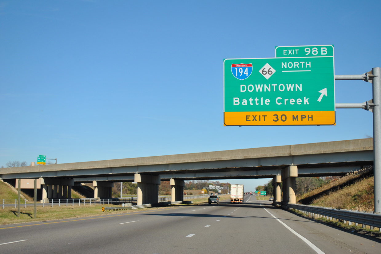
Exit 98B loops onto I-194/M-66 (Sojourner Truth Downtown Parkway) north. This is the fourth and final eastbound exit from I-94 to Battle Creek. 11/05/11
![]() West at
West at ![]()
![]()

I-94 progresses southwest from M-294 and Beadle Lake 1.25 miles to Exit 98B for I-194/M-66 north into Battle Creek. Photo by Don Hargraves (11/02).

Exit 98B departs from Interstate 94 west for I-194/M-66 north to Division Street along the east side of Downtown Battle Creek. Photo by Don Hargraves (11/02).

Interstate 94 advances west from I-194/M-66 at Exit 98 to Kalamazoo, Benton Harbor and Chicago, Illinois. Photo by Don Hargraves (11/02).
Sources:
- Bessert, C. (2026, May 8). Highways 180 through 199. Michigan Highways. https://www.michiganhighways.org/listings/MichHwys180-199.html#I-194
Page updated February 26, 2019.