Interstate 110 Texas

Overview
IH 110 is an unsigned route connecting IH 10 and U.S. 54 (Patriot Freeway) in El Paso with the Bridge of the Americas (BOTA) Port of Entry into Ciudad Juárez, Mexico. The short freeway defaults southbound to the BOTA Port of Entry, though a U-turn precedes the customs station. IH 110 southbound travels independent of U.S. 54 on flyover ramps, and the same northbound with the exception of the ramp to IH 10 west. U.S. 54 north from IH 10 along the Patriot Freeway is not a part of the Interstate highway system.
Sign changes made during the I-10 Connector Project in 2020 removed all references to IH 110. Local access from IH 110 to U.S. 62 (Paisano Drive) and Chamizal National Memorial was also removed.
IH 110 is one of two Interstate branch routes that end at the international border. The other is Interstate 190 at Niagara Falls, New York.
I-10 Connect Project
Started in Spring 2019, the three year I-10 Connect Project redesigned the IH 110 spur to the BOTA Port of Entry, and improved connectivity between IH 10 and SL 375 (Cesar E. Chavez Border Highway). Goals of the $96 million project addressed traffic congestion at the border crossing, and the use of local roads by commercial trucks to connect from IH 10 to Loop 375.
Route Information
North End – El Paso, TX
South End – El Paso, TX
Mileage – 0.696
Cities – El Paso
- Junctions –

Source: TxDOT Statewide Planning Map
I-110 Annual Average Daily Traffic (AADT)
| Location | Vehicles per day |
|---|---|
| South of US 62 | 32,405 |
| US 54 to IH 10 | 58,010 |
Source: 2020 AADT – TxDOT Statewide Planning Map
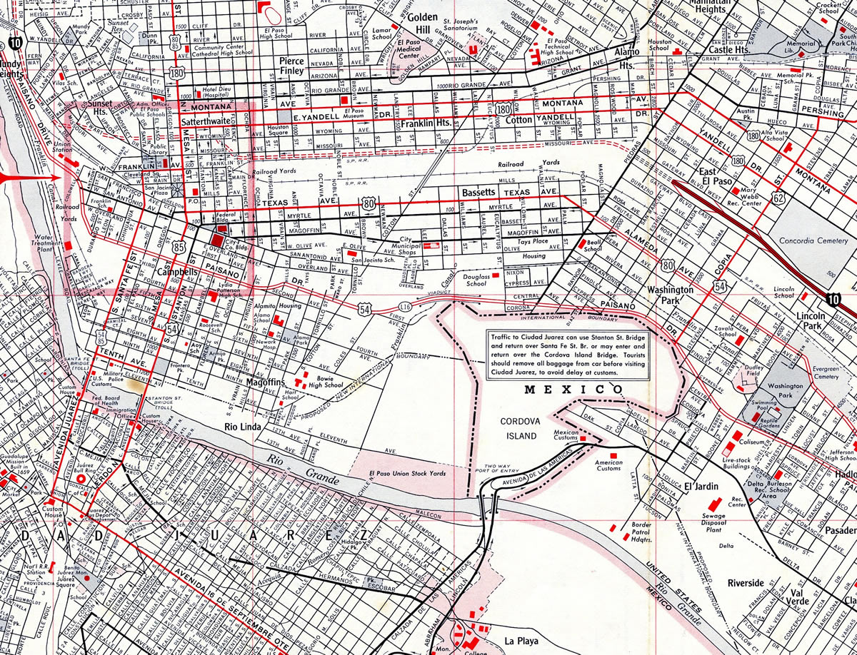
IH 110 travels through the Chamizal National Memorial. Located on both sides of the International border, the park was created after a boundary dispute between the United States and Mexico. The disputed land arose when the Rio Grande shifted course in 1864. Establishment of the memorial in 1964 settled the issue.

The Connect I-10 Project Area in El Paso.
Alternate 9, the selected option, eliminated the three level interchange joining IH 110 with U.S. 62 (Paisano Drive) and expanded the southbound roadway to six and eight lanes. The result of area residents’ complaints about border traffic passing through their neighborhoods, these changes eliminated local access along the freeway spur southbound with Paisano Drive and the entrance ramp from U.S. 62 onto IH 110 north. Reconstruction of the grade separation at IH 110 and U.S. 62 was completed in November 2021.1
Alternate 9 also added flyovers connecting both directions of IH 10 with U.S. 54 westbound to LP 375 (Cesar Chavez Border Highway), and a new ramp from U.S. 54 eastbound to the flyover linking IH 110 north with IH 10 east. A consultant at the Texas Department of Transportation (TxDot) open house meeting held in January 2017 indicated that signs for Juárez, Mexico will again omit IH 110.2
 History
The Texas Bureau of Public Roads approved the designation of IH 110 with 0.891 certified miles on March 28, 1967. The American Association of State Highway Officials (AASHO) approved the addition to the Interstate system on June 30, 1970. Completion of the freeway occurred in 1973.
Prior to 2010, the IH 110 designation was unmarked. Signs for IH 110 previously acknowledged only Juárez, Mexico from U.S. 54 (Patriot Freeway) southbound. Northbound signs leaving the port of entry from the Bridge of the Americans referenced only IH 10, U.S. 54 and U.S. 180.

IH 110 and U.S. 54 (Patriot Freeway) parallel one another in a dual freeway configuration before parting ways for Juárez, Mexico and Loop 375 respectively. The I-10 Connect project removed the ramp linking U.S. 54 with IH 110 just south of IH 10 and the exit from IH 110 to U.S. 62 (Paisano Drive). Photo by Jake Bear and Kevin Trinkle (08/07/10).
 Photo Guides
North End  – El Paso, Texas
![]() North at
North at ![]()
![]()
![]()

IH 110 runs along side U.S. 54 in a dual freeway configuration. The mainline separates into a slip ramp for U.S. 54 north to IH 10/U.S. 180 west and a flyover directly onto IH 10/U.S. 180 east. 04/25/17
![]()
![]() East at
East at ![]()
![]()

IH 10/U.S. 180 lead away from Downtown El Paso to Piedra Street and an easterly turn to a split diamond interchange (Exit 22 A) with Loop 478 (Copia Street). Exit 22 B quickly follows for IH 110 south and U.S. 54 (Patriot Freeway) east. 04/25/17

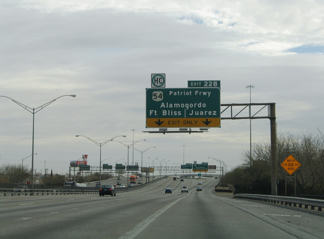
Two lanes separate from IH 10/U.S. 180 east for a lengthy flyover (Exit 22 B) to U.S. 54 (Patriot Freeway) east and IH 110 south. Signs for IH 110 only reference Juárez, Mexico. 04/25/17

Two lanes connect IH 10/U.S. 180 east with U.S. 54 (Patriot Freeway) east to Fort Bliss. The single lane flyover for IH 110 southbound to the BOTA Port of Entry was replaced during the I-10 Connector project with an expanded flyover including access to U.S. 54 west to Loop 375. 04/25/17
![]()
![]() West at
West at ![]()
![]()

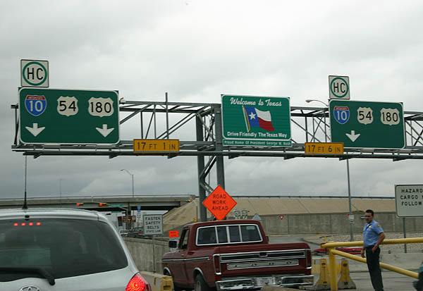
Guide signs along IH 10 omit IH 110, instead referencing Juárez, Mexico. Sign changes made during the I-10 Connector project added SL 375 and removed Alamogordo. U.S. 180 combines with IH 10 west from U.S. 62 (Paisano Drive). 04/25/17.

IH 10 travels below grade with eight overall lanes from Raynolds Street west to the four-level interchange with IH 110 south and U.S. 54 (Patriot Freeway) east. 04/25/17

Two lanes depart from IH 10/U.S. 180 west for U.S. 54 (Patriot Freeway) eastbound to Fort Bliss, U.S. 54 westbound to SL 375 (Cesar Chavez Border Highway) and IH 110 south to Juárez, Mexico. The I-10 Connector project added the flyover to U.S. 54 south ahead of SL 375. 04/25/17

Traffic partitions along the flyover from Exit 22B for U.S. 54 (Patriot Freeway) east to Alamogordo, New Mexico and IH 110 south to U.S. 62 (Paisano Drive) and the Bridge of the Americas into Mexico. Photo taken 04/25/17.
 North End Throwback
![]() South at
South at ![]()

Flyovers from IH 10/U.S. 180 combine alongside U.S. 54 (Patriot Freeway) south. Two lanes continued directly to the former three-level interchange with U.S. 62 and the BOTA Port of Entry from IH 110 south. 04/25/17

IH 110 formerly partitioned with U.S. 54 (Patriot Freeway) at a wye interchange. Ramps simultaneously joined IH 110 south from U.S. 54 west and departed from IH 110 south to U.S. 62 (Paisano Drive). 04/25/17
![]() North
North ![]() East
East

IH 110 shifted eastward through a wye interchange to emerge along the right side of U.S. 54 (Patriot Freeway) north leading to IH 10/U.S. 180. 01/14/06

These button copy signs formerly directed traffic at the ramp split (then Exit 1 A) from IH 110 north. They were replaced by 2005. Photo by Jeff Royston (12/00).

The connection from IH 110 north to IH 10/U.S. 180 west requires motorists to briefly merge onto U.S. 54 (Patriot Freeway) eastbound. 01/14/06

A distributor roadway and loop ramp (Exit 21 B / old Exit 1 C) for IH 10/U.S. 180 west departs from U.S. 54 east a short distance after the IH 110 end. 01/14/06
![]() East at
East at ![]()

This sign bridge directed traffic to both Copia Street and the forthcoming flyovers for U.S. 54 (Patriot Freeway) and IH 110 south. It was removed by 2007. 01/14/06
Former button copy overhead posted along IH 10 east at the Raynor Street underpass for U.S. 54 and unsigned IH 110. U.S. 54 originates 1.2 miles to the south at Loop 375. 01/14/06

Two lanes part ways with IH 10/U.S. 180 east a half mile ahead of the four level interchange with U.S. 54 (Patriot Freeway) and IH 110. The two routes travel side by side toward U.S. 62 (Paisano Drive). 01/14/06

Traffic partitioned between a two lane flyover for U.S. 54 (Patriot Freeway) east toward Fort Bliss and Alamogordo, New Mexico and a single lane ramp onto unsigned IH 110 south. 01/14/06
South End – / Bridge of the Americas Port of Entry – El Paso, Texas
![]() South
South

Two lanes of IH 110 emerge from below U.S. 62 (Paisano Drive) ahead of the Cordova International Bridge over the Rio Grande. Photo by Robert Lee (06/06).

Entering the BOTA Port of Entry at the south end of IH 110. With the exception of the final U-turn to the left, all traffic defaults into Ciudad Juárez, Mexico. Photo by Robert Lee (06/06).
![]() North
North

Guide signs installed beyond the customs station in 2010 acknowledged IH 110. Traffic exiting the border station from the left defaults onto the freeway north to IH 10, while the right exit includes access to U.S. 62 (Paisano Drive). 04/25/17

IH 110 northbound begins as three lanes ascend from the BOTA Port of Entry to U.S. 62 (Paisano Drive) west to Downtown El Paso and east to U.S. 54 (Patriot Freeway), the El Paso Zoo and the El Paso County Coliseum. 04/25/17
South End Throwback
![]() North
North
Button copy signs at the northbound beginning of IH 110 previously referenced only the connections with IH 10 and U.S. 54/180. Photo by Kevin Trinkle (07/31/06).

Service roads connected ramps between IH 110 and U.S. 62 (Paisano Drive) at signalized intersections. Chamizal National Memorial lies southwest of the removed exchange. 04/25/17

Button copy signs at the former ramp split from U.S. 62 (Paisano Drive) to IH 110 north and San Antonio Street. 01/14/06

The former entrance ramp from U.S. 62 (Paisano Drive) to IH 110 north includeds local access to San Antonio Avenue. The I-10 Connect project retained the connection to the adjacent neighborhood. 04/25/17
![]() Patriot Freeway west at
Patriot Freeway west at ![]()
![]()

Button copy signs posted on the westbound viaduct along U.S. 54 (Patriot Freeway) a half mile ahead of what was Exit 0 B to unsigned IH 110. 01/14/06

Flyover ramps from IH 10 east and west combine to form the southbound roadway of IH 110 adjacent to the U.S. 54 (Patriot Freeway) mainline. Photo by Jake Bear and Kevin Trinkle (08/07/10).

Signs for IH 110 only referenced Juárez, Mexico prior to 2010. U.S. 54 ends in three quarters of a mile at State Loop 375 (Cesar Chavez Border Highway). 01/14/06

A wye interchange (Exit 20 B) previously linked U.S. 54 (Patriot Freeway) with IH 110 south beyond the SH 20 (Alameda Avenue) under crossing. Photo by Jake Bear and Kevin Trinkle (08/07/10).

Guide signs over the ramp from IH 110 south to U.S. 62 (Paisano Drive) previously referenced the connection from U.S. 62 to U.S. 54 west for Loop 375 (Cesar Chavez Border Highway) Photo by Kevin Trinkle (02/27/05).

The zero milepost for IH 110 stands just beyond the Bridge of the Americas Port of Entry. Photo by Robert Lee (06/06).
![]() West at
West at ![]()

U.S. 62 (Paisano Drive) met IH 110 just north of the Bridge of the Americas Port of Entry. The full access exchange provided connections with IH 110 north to U.S. 54 (Patriot Freeway) and IH 10, and the border crossing south to Federal Highway 45 in Ciudad Juárez. The I-10 Connect project eliminated this interchange. 01/14/06
![]() East at
East at ![]()

U.S. 62 originates alongside U.S. 85 at the border crossing along El Paso Street south of Downtown El Paso. Paisano Drive leads U.S. 62 east along a four lane arterial to Chamizal National Memorial and the removed exchange with IH 110. 01/14/06
Sources:
- “I-10 connect project on Paisano Drive complete.” KDBC TV-4 News (El Paso, TX), November 4, 2021.
- “Will I-110 (TX) go un-signed once again?” online posting by mwb1848, AARoads Forum, August 25, 2016.
Page updated June 5, 2022.