Interstate 110 Mississippi

Overview
Interstate 110 is a short freeway spur linking I-10 and MS 15/67 at D’Iberville with U.S. 90 (Beach Boulevard) and Downtown Biloxi. The freeway incorporates one of the few drawbridges in the Interstate system as it crosses the Back Bay of Biloxi between Exits 1 D and 2. South from the span, I-110 elevates along a four lane viaduct, with the trumpet interchange at U.S. 90 partially spanning waters of the Gulf of Mexico.

Southbound Interstate 110 at the draw bridge signal on the Back Bay of Biloxi Bridge. 10/12/16
 History
Interstate 110 fully opened to traffic between U.S. 90 in Biloxi and I-10 at D’Iberville in 1988.1
Mississippi Highway 15 formerly overlapped with all of Interstate 110 until March 2009. Opening at that time, construction of the Biloxi – D’Iberville Scenic Expressway included a new alignment for MS 67 to the southeast and a trumpet interchange with MS 15. As a result, MS 15 was truncated to the MS 67, with MS 67 extended south over former MS 15 to the cloverleaf interchange with I-10 and I-110. MS 15 previously ran along Caillavet Street and Central Avenue to the east of I-110 through Biloxi and D’Iberville.
Making landfall on August 29, 2005, Hurricane Katrina devastated Biloxi, Gulfport and the Mississippi Gulf Coast. Long segments of U.S. 90 were destroyed in the process, but damage to Interstate 110 was minimal and the freeway quickly reopened.
Route Information
North End – D’Iberville, MS
South End – Biloxi, MS
Mileage – 4.10
Cities – Biloxi, D’Iberville
- Junctions –

Source: December 31, 2021 Interstate Route Log and Finders List
I-110 Annual Average Daily Traffic (AADT)
Source: 2019 AADT – Mississippi Department of Transportation (MDOT) Traffic Volume

Interstate 110 spurred south to the Bayview Drive ramps just across the Back Bay of Biloxi in 1977. MS 15 remained posted from there south along Caillavet Street to U.S. 90 by Downtown.

Built in 1848, Biloxi Lighthouse from the flyover joining I-110 south with U.S. 90 (Beach Boulevard) east along Mississippi Sound. 05/09/15
Construction started in 2013 on Phase I of the Interstate 10/110 Interchange Improvements project at D’Iberville. The $29.7 million project included new interchanges along I-10 at Galleria Parkway (formerly D’Iberville Boulevard) and Lamey Bridge Road. Work also realigned the loop ramps joining I-10 and I-110 while adding a collector distributor roadway along I-10 east and auxiliary lanes. Costing $11.4 million, Phase II started in March 2014. This added a half diamond interchange between Big Ridge Road, since renamed as an extension of Popps Ferry Road, and I-110.2
The c/d roadway from Interstate 10 east to I-110 opened on January 21, 2015.3 The Diverging Diamond Interchange (DDI) at Galleria Parkway opened to traffic following a ribbon cutting ceremony on June 2, 2015.4 The new ramps between I-110 and Popps Ferry Road opened on September 3, 2015, with a formal ribbon cutting ceremony wrapping up all work on the two phase project.5 A flyover remains planned to replace the loop ramp connecting Interstate 10 west with I-110 south. Lack of funding delayed the project until at least 2025.5
A separate four phase project focused on the replacement of the at-grade intersection of MS 67 with Promenade Parkway / Sangani Boulevard just beyond the north end of Interstate 110. Work on the $7.3 million project started in March 2012. The congested intersection was replaced with a folded diamond interchange and a 17 foot high overpass spanning MS 67. The ramps to MS 67 opened on July 25, 2013, while side work on Sangani Boulevard continued through November 2013.6
Most of the sign assemblies along Interstate 110 on the Walter L. Nixon Memorial Bridge over the Back Bay of Biloxi and the elevated freeway through Biloxi were removed by November 2015. Overall 20 overhead signs were taken down by the Mississippi Department of Transportation (MDOT) as part of sign replacement project underway throughout southeast Mississippi. The project replaced sign bridges with cracked and substandard trusses with new assemblies adhering to current hurricane standards.7
 Photo Guides
North End  – D’Iberville, Mississippi
![]() North at
North at ![]()
![]()

I-110/MS 67 spans Rodriguez Street 0.75 miles from the cloverleaf interchange (Exits 4B/C) with Interstate 10. 11/20/15

A pair of Arrow Per Lane (APL) signs precede the departure of Exits 4A/B for Popps Ferry Road and Interstate 10 east. 11/20/15

Two lanes branch away from the I-110 mainline for Popps Ferry Road at D’Iberville and Interstate 10 east to Pascagoula and Mobile, Alabama. 11/20/15

The exit ramp to Popps Ferry Road opened in September 2015 to provide additional access to north D’Iberville and the Promenade retail area adjacent to the I-10/110 exchange. I-10 accommodates four eastbound lanes to MS 609 at Ocean Springs. 11/20/15

Exit 4B to I-10 west was renumbered as Exit 4C when the Popps Ferry Road exit opened to traffic in September 2015. 10/12/16

An end sign for Interstate 110 appears as Exit 4C loops onto the c/d roadway leading west toward Gulfport. 11/20/15
![]() South at
South at ![]()
![]()

MS 15/67 advance south from the intersection with Old Highway 67 one half mile to the cloverleaf interchange with I-10 and I-110. 11/20/15

The entrance ramp from Promenade Parkway forms two auxiliary lanes from MS 15/67 south to Interstate 10 west (Exit 4B). 11/20/15

MS 15/67 end as Interstate 110 south begins. I-10 travels west from Exit 4B to Gulfport, Slidell and New Orleans in southeastern Louisiana. 11/20/15

A loop ramp (Exit 4A) follows for Interstate 10 east to Jackson County, Ocean Springs, Gautier and Moss Point. 11/20/15
![]() East at
East at ![]()
![]()

Interstate 10 advances east to the DDI (Exit 46 A) with Galleria Parkway and Exits 46 B/C with Interstate 110 and MS 15/67. 05/11/22

A fourth eastbound lane opens ahead of the collector distributor roadway for Galleria Parkway. The c/d roadway initially opened in January 2015. 05/11/22

Two lanes partition from the eastbound I-10 mainline for I-110 south to Biloxi, MS 15 north to DeSoto National Forest and MS 67 north to Cedar Lake. 05/11/22

Exit 46 A departs for Galleria Parkway, which was formerly D’Iberville Boulevard and Old Highway 67. D’Iberville Boulevard was also part of the original alignment for MS 15, which I-110 replaced south into Biloxi. 05/11/22

Interstate 110 leads south from I-10 and MS 15/67 through D’Iberville to U.S. 90 west of Downtown Biloxi and east of Keesler A.F.B. 05/11/22
![]() West at
West at ![]()
![]()

Interstate 10 expands from six to eight lanes between MS 609 (Exit 50) and Interstate 110 (Exits 46B/A). 11/20/15

Exit 46 represents the shared end point of both Interstate 110 north and MS 15/67 south. MS 15/67 split at a trumpet interchange 2.3 miles to the north of I-10. 11/20/15

A collector distributor roadway separates from I-10 west to I-110, MS 15/67 and Exit 46D to Lamey Bridge Road. 11/20/15

I-10 enters the city of D’Iberville at the exchange with I-110/MS 15-67. Exits for Lamey Bridge Road, Sangani Boulevard and Promenade Parkway serve the adjacent retail area to the north. 11/20/15

Exit 46C departs below the Lamey Bridge Road overpass. MS 67 commences a 20.25-mile course northwest to U.S. 49 at Saucier here. 11/20/15

Exit 46B loops onto Interstate 110 south toward Biloxi and Keesler Air Force Base. Long range plans outline replacing this ramp with a flyover. 11/20/15
 North End Throwback
![]()
![]() North at
North at ![]()

Former guide sign posted 0.75 miles south of Exits 4A/B with Interstate 110. Exit 4A was shifted further south as part of the new distributor road for Popps Ferry Road in September 2015. Photo by Chris Patriarca (06/25/03).

MS 15 used to continue north from the Interstate 110 end toward DeSoto National Forest. The route now begins 2.3 miles further north from the MS 67 expressway. Photo by Chris Patriarca (06/25/03).

Approaching the original traffic light with Mallett Road, which then served just a handful of traveler services. Photo by Chris Patriarca (06/25/03).

MS 15 proceeded north from Mallett Road to cross the Biloxi River and curve west and then north along a rural highway north to MS 26 in Stone County. Opened in 2009, a four-lane expressway replaced a portion of this alignment northward. Photo by Chris Patriarca (06/25/03).
![]() South at
South at ![]()
![]()

The original cloverleaf interchange joining MS 15 with I-10/110 became increasingly congested once then Promenade shopping center opened for business in 2009. 11/19/08

Mississippi Highway 15 formerly combined with Interstate 110 south to U.S. 90 (Beach Boulevard) along the Biloxi waterfront. 11/19/08
![]() East at
East at ![]()
![]()

Construction widening Interstate 10 to six lanes west of I-110/MS 15 was completed in Fall 2003. Photo by Chris Patriarca (06/25/03)

Exit 46A for I-110/MS 15 south previously departed from the mainline of I-10 east beyond the D’Iberville Boulevard overpass. 10/14/03
South End – Biloxi, Mississippi
![]() South at
South at ![]()

A pair of end signs for I-110 precede the Back Bay of Biloxi bridge at Rodriguez Street (Exit 2). 11/20/15
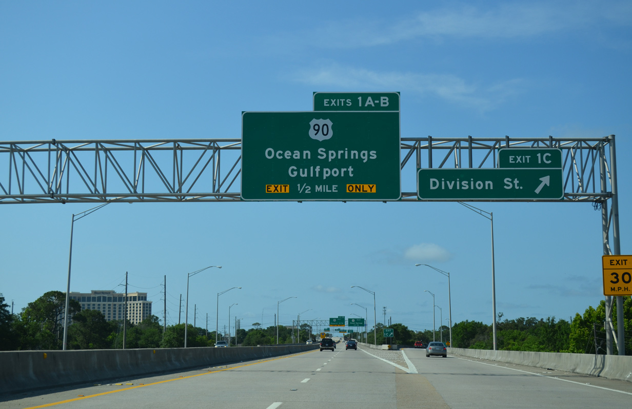
A half diamond interchange (Exit 1C) connects I-110 south with Division Street at Hopkins Boulevard, one half mile from U.S. 90 (Exits 1A/B). 05/09/15

This end sign references the flyover connecting I-110 south with U.S. 90 (Beach Boulevard) west to Downtown. 05/09/15

The Interstate 110 southbound mainline defaults onto U.S. 90 (Beach Boulevard) west toward the main gate for Keesler Air Force Base. A flyover ramp serves casinos to the east and Ocean Springs in adjoining Jackson County. 05/09/15

Exit 1B lowers from the I-110 viaduct to a right turn for U.S. 90 (Beach Boulevard) west to Keesler AFB and Gulfport. 05/09/15

Exit 1A loops over waters of the Gulf of Mexico before joining U.S. 90 (Beach Boulevard) eastbound ahead of Caillavet Street (old MS 15). The I-110 Loop Walk runs along the outside of the interchange below. 05/09/15
![]() East at
East at ![]()

U.S. 90 passes by Biloxi Lighthouse between the Keesler AFB area and the south end of Interstate 110. 06/09/10

The flyover for Interstate 110 north to D’Iberville, I-10 and MS 67 departs from U.S. 90 (Beach Boulevard) alongside a public beach. 04/05/12
![]() West at
West at ![]()

U.S. 90 (Beach Boulevard) advances one half mile west from a public beach by a pair of casinos to Interstate 110. 05/09/15

A modified trumpet interchange joins U.S. 90 with Interstate 110. Right in and right out (RIRO) ramps connect Beach Boulevard westbound with the freeway below flyovers serving eastbound traffic. 05/09/15
South End Throwback
![]()
![]() South at
South at ![]()

Replaced guide signs along I-110 south at Exit 1C for Division Street. 06/10/06

Sign changes made here replaced Next Right with Exit 1A for U.S. 90 east. 06/10/06

Exits 1A/B partitioned for U.S. 90 (Beach Boulevard) below these former guide signs. 06/10/06
![]() at
at ![]()
![]()

This shield assembly was removed when MS 15 was truncated northward from Biloxi to the Biloxi – D’Iberville Scenic Expressway. 09/16/00

Original signage posted for Interstate 110 north from U.S. 90 omitted cardinal direction banners. 09/16/00

One quarter mile east of the trumpet interchange with I-110/MS 15 on U.S. 90 (Beach Boulevard) west by the Beau Rivage hotel and casino complex. This overhead was dismantled and replaced by a new overhead further east. 06/10/06

Replaced guide sign referencing I-110/MS 15 north from Beach Boulevard west. The building beyond the flyovers was demolished after Hurricane Katrina hit the Gulf Coast in 2005. 06/10/06
Sources:
- Mississippi Department of Transportation (MDOT). U.S. Highway 90 History. http://www.mdothwy90.com/documents/US_90_Project_History.pdf
- MDOT announces updates on South Mississippi road projects. (2014, June 2). GulfLive.com. https://www.gulflive.com/mississippi-press-news/2014/06/mdot_announces_updates_on_sout.html”>MDOT announces updates on South Mississippi road projects.
- “New Ramp on I-10 in D’Iberville Now Open.” WXXV, January 21, 2015.
- “Drivers react to Mississippi’s first Diverging Diamond Interchange.” WLOX (Biloxi, MS), June 2, 2015.
- “D’Iberville and MDOT will celebrate the end of I-10/110 work.” Sun Herald, September 2, 2015.
- “D’Iberville bridge opens Thursday.” Sun Herald, July 22, 2013.
- “How important is one highway sign?” SunHerald, July 14, 2016.
Page updated June 30, 2022.