Interstate 74 North Carolina
Overview
As of June 2013, Interstate 74 is designated along three sections in North Carolina: (1) near Mount Airy, (2) from I-40 at Winston-Salem south to Richmond County, a portion of which is concurrent with I-73, and (3) between Laurinburg and Lumberton. Additional segments are planned or under construction, including the Rockingham Bypass and Winston Salem Northern Beltway.
Interstate 74 was first proposed for extension into West Virginia and the Carolinas with the passage of the National Highway Designation Act of 1995. While the original I-74 still ends in Cincinnati, it is highly unlikely that the route will continue east toward Huntington, West Virginia. I-74 is not signed in either Virginia or South Carolina either.
The first section of Interstate 74 in North Carolina follows the Mount Airy bypass 13 miles east from I-77 near the Virginia state line. South of Toast and Mount Airy, the segment through Surry County opened initially between I-77 and U.S. 601 on July 14, 19981 and from U.S. 601 to U.S. 52 on July 1, 1999. Construction on the $78.8 million roadway took eight years.2 I-74 replaced North Carolina Route 752 along the freeway by 2001. The 4.6 mile long concurrency with I-77 north to the state line was signed in April 2001.
Future I-74 Corridor signage remains in place on U.S. 52 between the east end of the Mount Airy section to northern reaches of Winston-Salem. This section of freeway remains below full Interstate standards.
The Winston-Salem Northern Beltway will carry I-74, 17.1 miles around the northeast side of the city to I-74 (former U.S. 311) near Union Cross. Initial construction between U.S. 421 (Salem Parkway) and Reidsville Road (U.S. 158), was scheduled to start in 2014.3 The North Carolina Department of Transportation (NCDOT) awarded a $33.2 million contract for a 1.9 mile section of the Winston-Salem Northern Beltway project in December 2017. Work starting in January 2018 included grading, draining work, bridge construction and signing along future I-74 from U.S. 311 to U.S. 158.21
The first stretch of the Winston-Salem Northern Beltway opened to traffic on September 5, 2020. Designated NC 74, the four mile section links U.S. 421 (Salem Parkway) with U.S. 158 (Reidsville Road). Originally scheduled for completion in November 2021, the succeeding two miles of NC 74, from U.S. 158 to U.S. 311, opened on December 23, 2020.27 NC 74 will become I-74 once all six sections on the eastern side of the Beltway are completed.24
Southeast from Winston-Salem, Interstate 74 replaced U.S. 311 along a freeway from I-40 near Union Cross to High Point, Archdale, New Market and Randleman. Designated as part of U.S. 311 until 2018, the first 12.2 miles of the freeway, from southeast Forsyth County to the Guilford County line, opened on March 6, 1984.4 The High Point Bypass extended that route southward as a limited access highway 3.7 miles to Eastchester Drive (NC 68) on September 18, 1997,5 and from there to Business Loop I-85/U.S. 29-70 on November 20, 2004.6 This stretch was signed as Interstate 74 when the Archdale bypass opened on November 22, 2010, following three years of construction.7
The succeeding section of Interstate 74 opened on June 7, 2013 at a cost of $99.7 million. This linked the freeway end at Glenola with I-73 at Randleman.8 It also completed I-74 between Forsyth County and Ellerbe in southern North Carolina.
U.S. 220 was redesignated as I-73/74 in the mid-1990s from U.S. 64 at Asheboro southward to Candor. The 12.6-mile stretch from Ulah through Seagrove opened on August 27, 1996 at a cost of $47.5 million.9 The freeway north from U.S. 64 at Asheboro to Randleman was signed as Future I-73/74 until June 2013, when the route opened northwest to High Point.
17 miles of new freeway for U.S. 220 opened south from Candor to Ellerbe on January 7, 2008.10 This portion, while built to Interstate standards, was signed as a Future route until March 2013.3 Future corridor signs accompany the non-freeway portion of U.S. 220 south of Ellerbe to Rockingham.
A new alignment will take I-73/74 southwest from U.S. 220 to the west end of the U.S. 74 Rockingham Bypass. Construction for 3.7 miles of the northern leg of the bypass commenced on March 3, 2014. Completed in June 2018, work upgraded U.S. 220 south to a new trumpet interchange with Harrington Road.11

Construction for I-73/74 at the north end of the Rockingham Bypass was completed by June 2018. This view looks south from the Harrington Road (SR 1304) overpass. 08/14/21
Route Information
East End – Lumberton, NC
West End – Pine Ridge, NC
Mileage – 75.03
Cities – Mt. Airy, Winston-Salem, High Point, Randleman, Asheboro, Ulah, Candor, Ellerbe, Rockingham, Laurinburg, Lumberton
Junctions –
 Future
Source: December 31, 2021 Interstate Route Log and Finders List
19.17 miles on I-73

The Laurinburg and Maxton bypasses were both signed as Interstate 74 starting in November 2008. Due to the freeway not adhering to Interstate standards, sign changes removing I-74 assemblies along both freeways were made by mid 2009.12
Until early 2016, the freeway along U.S. 74 across the south side of Rockingham was signed with Future Interstate signs east to the planned split of I-73 south near NC 38.22 The February 2016 edition of the NCDOT STIP revised the entry for the I-73/74 Bypass in Richmond County. The listing included funding for construction of I-73/74 slated for 2022. Work running through 2025 was expected to coincide with upgrades to U.S. 74 east to Interstate standards from Rockingham to Hamlet.16 However funding was not secured until the 2018-2027 Draft STIP, which outlined $70.2 million for construction of the new Rockingham Bypass from U.S. 74 Bypass north to Zion Church Road (SR 1140), and $74.5 million from SR 1140 north to Harrington Road (SR 1304). Both were projected to start in 2026.18,22
Funding for construction of the Rockingham Bypass was eventually secured and work on the southern 7.2 mile long section south of Harrington Road (SR 1304) got underway in November 2019. Split into three sections and estimated to cost $278 million, work runs through April 2024.
A portion of U.S. 74 remains an at-grade highway between the Hamlet bypass and the Laurinburg Bypass. West of Laurinburg, U.S. 74 upgrades to a freeway east to Maxton. The initial 14 mile segment is designated Future I-74 as planned upgrades to Interstate standards are estimated for 2027 and beyond.

U.S. 74 shifts onto the Laurinburg bypass freeway just east of the J-turn intersection with SR 1321 (Elmore Road). The Laurinburg bypass was initially signed as Interstate 74. 07/28/13
The third segment of I-74 runs 19 miles east of Maxton to the city of Lumberton. Completed September 26, 2008,10 the freeway transitions into an at-grade highway 7.8 miles south of NC 41. Funding in the 2016-25 State TIP included upgrading U.S. 74 to I-74 in Robeson County.17 However project work to bring U.S. 74 up to Interstate standards through Scotland County was not funded in the 2018-2027 Draft STIP for NCDOT Division 8.18
A $7.5 million project was awarded in October 2017 for the conversion of the intersection at U.S. 74 and Broadridge Road in Robeson County into an interchange (Exit 219). Associated work reconfigured the intersection with Creek Road, 1.5 miles to the south, into a directional crossover. The two year project started after November 27, 2017.19 Beyond Robeson County, U.S. 74 angles southeast to Chadbourn, where the route combines with U.S. 76 for a bypass of Whiteville.
Near the point where U.S. 74 and U.S. 76 combine at Chadbourn, a proposed but unlikely easterly extension of Interstate 20 was slated to tie into I-74. I-20 concludes in Florence, South Carolina but was envisioned to combine with I-74 between Chadbourn and Bolton via Whiteville en route to a proposed end at Wilmington. The governor of North Carolina introduced the new route of I-20 and I-74 in his Strategic Transportation Plan for Southeastern North Carolina on May 5, 2003.
Following NC 211 south from Bolton to Supply, the I-74 corridor turns westerly along the course of U.S. 17 to South Carolina and the Carolina Bays Parkway (S.C. 31) at S.C. 9. A northeast to southwest route with six lanes, the 28 mile long Carolina Bays Parkway provides an inland bypass of U.S. 17, Myrtle Beach and the Grand Strand area. Following three years of construction, the freeway opened to traffic on December 17, 2002.11
Interstate 74 in South Carolina is proposed along all of Carolina Bays Parkway, which doubles as future I-73 from S.C. 22 (Conway Bypass) southwest to S.C. 707 near Socastee. The first leg of the parkway completed was the portion between S.C. 9 and U.S. 501. Costing $232 million, the 20 mile long highway opened to traffic on December 17, 2002.13 Next, opened on December 15, 2004, was the six lane freeway extending S.C. 31 southwest 4.6 miles from U.S. 501 to S.C. 544.14
Ground breaking on a 3.8 mile long extension of Carolina Bays Parkway south from S.C. 544 to S.C. 707 took place on November 6, 2013. With costs between $225-237 million, construction was estimated for completion by Spring 2017.15 However, bad weather and cracks discovered in a bridge over the Intracoastal Waterway delayed the project from opening until November 7, 2019.25
Plans for the east end of Interstate 74 changed substantially since 1995, when it was first proposed to be extended east. The original ISTEA/NHS legislation indicated that I-73/74 would continue beyond Georgetown southwest into Charleston, but that was removed (per the TEA-21 law passed in 1998).
A joint study by the North and South Carolina Departments of Transportation commenced in September 2017 for the Carolina Bays Parkway Extension. The proposed route begins from S.C. 31 at S.C. 9 in Horry County, South Carolina and ends to the northeast at U.S. 17 near Shallotte in Brunswick County, North Carolina. Alternatives for the estimated $551.7 million project were initially expected in 2019.20
High Priority Corridor
North Carolina’s two sections of Interstate 74 are part of High Priority Corridor 5: I-73/74 North-South Corridor. Its designation in North Carolina is written into law.
 History
I-73 and I-74 were initially submitted to the American Association of State Highway and Transportation Officials (AASHTO) for approval at the Special Committee on Route Numbering meeting on April 19, 1996. North Carolina submitted three requests under Section 332(a)(2) of the National Highway System Designation Act of 1995. They were all denied:
- Establish Interstate 73 – “Beginning at the intersection of U.S. Route 220 at the Virginia State Line, then southerly over U.S. Route 220 to the intersection of State Route 68 northwest of Greensboro, then southerly over U.S. Route 68 (sic) to the intersection of Interstate Route 40 in Kernersville, then southeasterly over I-40 to the intersection of U.S. Route 220 in Greensboro, then southerly over U.S. Route 220 to the intersection of U.S. Route 1 in Rockingham, then southwesterly over U.S. Route 1 to the South Carolina State Line.” The action to establish this route was continued at the April 1996 meeting, and it was subsequently amended in future iterations by North Carolina and adjacent states.
- Establish Interstate 74 – “Beginning at the intersection of Interstate Route 77 at the Virginia State Line, then southerly over I-77 to the intersection of U.S. 52 south of Mount Airy, then southeasterly over U.S. Route 52 to the intersection of U.S. Route 311 in Winston-Salem, then easterly and southeasterly over U.S. Route 3111 to the intersection with U.S. Route 220 in Randleman, then southerly over U.S. Route 220 to the intersection of U.S. Route 74 in Rockingham then southeasterly over U.S. Route 74 to the intersection of U.S. Route 76 in Whitehall, then westerly over U.S. Route 76 to the South Carolina State Line.” The action to establish this route was continued at the April 1996 meeting, and it was subsequently amended in future iterations by North Carolina and adjacent states.
- Establish Temporary Interstate 74 – a request was made to establish a temporary designation along U.S. 52 from Interstate 40 north 11.22 miles to the intersection with North Carolina 1840. This request was disapproved in favor of “To Interstate 74.”
Once the proposals for I-73 and I- 74 were resubmitted in a joint proposal by Virginia, North Carolina, and South Carolina, AASHTO approved them as Interstate Highways via a mail ballot completed on July 25, 1996. The results of this ballot were approved as part of the meeting of October 5, 1996. The routes were modified into the following descriptions:
- Establish Interstate 73 – “Beginning at the intersection of Interstate Route 81 and Interstate Route 581 north of Roanoke, Virginia, then southeasterly over I-581 to the intersection of U.S. Route 220 at the Virginia State Line, then southerly over U.S. Route 220 to the intersection of State Route 68 northwest of Greensboro, then southerly over U.S. Route 68 (sic) to the intersection of Interstate Route 40 north of High Point, then southeasterly over I-40 to the intersection of U.S. Route 220 in Greensboro, then southerly over U.S. Route 220 to the intersection of U.S. Route 1 in Rockingham, then southwesterly over U.S. Route 1 to the intersection of State Route 9 near Cheraw, South Carolina, then southerly over S.R. 9/38 to the intersection of U.S. Route 501 near Marion, then southerly over U.S. Rout(e) 501 (sic) to the intersection of U.S. Route 701 in Conway, then southwesterly over U.S. Route 701 to the intersection of U.S. Route 17 in Georgetown, then southerly over U.S. Route 17 to the terminal interchange of Interstate Route 26 in Charleston, South Carolina.” The southern terminus of this route, along with certain other segments, would be modified in the ensuing years.
- Establish Interstate 74 – “Beginning at the intersection of Interstate Route 81 and Interstate Route 77 east of Wytheville, Virginia, then southerly over I-77 to the intersection of U.S. Route 52 south of Mount Airy, then southeasterly over U.S. Route 52 to the intersection of U.S. Route 311 in Winston-Salem, then easterly and southeasterly over U.S. Route 3111 to the intersection with U.S. Route 220 in Randleman, then southerly over U.S. Route 220 to the intersection of U.S. Route 74 in Rockingham then southeasterly over U.S. Route 74 to the intersection of a new facility to be constructed west of Whiteville, then southerly over the new facility to the intersection of U.S. Route 17 southwest of Wilmington, then southwesterly over U.S. Route 17 to the intersection of proposed Interstate Route 73 at a point yet to be determined in near Myrtle Beach, South Carolina.”
 Photo Guides
Laurinburg to Lumberton
West End – ![]()
![]() – east of Maxton
– east of Maxton

The Laurinburg and Maxton bypasses for U.S. 74 remain a part of Future I-74 until upgrades to Interstate standards are made. I-74 resumes east of the six-ramp parclo interchange (Exit 194) with U.S. 74 Business west back into Maxton. 07/28/13

Exit 194B loops away from U.S. 74 east for U.S. 74 Alternate toward Pembroke as Interstate 74 begins. 07/28/13
East End – ![]()
![]() – Lumberton
– Lumberton
![]()
![]() East at
East at ![]()

Interstate 74 extends 3.8 miles east from I-95/U.S. 301 to conclude at NC 41 on the southwest side of Lumberton. 07/28/13

An end shield for Interstate 74 stands just beyond the diamond interchange (Exit 213) with NC 41. The freeway continues another 7.8 miles past Broadridge Road (SR 2220), where a grade separation was constructed from April 12, 2018 to September 2019.28 07/28/13
![]() West at
West at ![]()
![]()

U.S. 74 travels northwest from the partition with U.S. 76 near Chadbourn and across the Lumber River to upgrade into a freeway six miles south of NC 41 (Exit 213). 07/28/13

Beyond Exit 213 for NC 41 north to Lumberton and south to Fairmont, Interstate 74 accompanies U.S. 74 west toward Maxton and Laurinburg. 07/28/13
Winston-Salem to Rockingham
West End – ![]() – Winston-Salem
– Winston-Salem

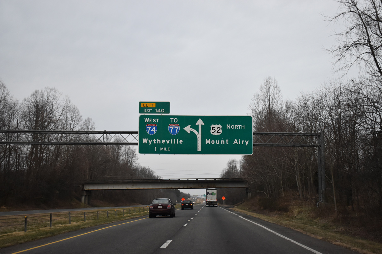
I-74 was extended westward along U.S. 311 from High Point to Forsyth County in March 2013. I-74 will turn north onto the Winston-Salem Beltway ahead of I-40 and this segment will be redesignated NC 192.26 07/09/10

A wide trumpet interchange (Exit 55) joins I-74 with Interstate 40 in southeast Winston-Salem. References for U.S. 311 were removed along I-74, I-40 west and U.S. 52 north to Downtown Winston-Salem in Fall 2019.26 07/09/10

Interstate 40 east at the trumpet interchange (Exit 196) with I-74 east in Winston-Salem. This section of I-74 will be redesignated NC 192 when I-74 is rerouted to the east. 08/15/21
East End – ![]() – south of Ellerbe
– south of Ellerbe

Construction finished in June 2018 upgraded U.S. 220 three miles north from Harrington Road (SR 1304) and a partially built trumpet interchange with the Rockingham Bypass (Future I-73/74) to Interstate standards. 08/14/21

U.S. 220 previously transitioned into I-73/74 at the diamond interchange with U.S. 220 Business south of Ellerbe. Begin shields for I-73/74 were added here by 2014, with the exit renumbered from 8 to 25. 12/21/08
Mt. Airy / Surry County
East End – ![]() – Mount Airy, North Carolina
– Mount Airy, North Carolina
![]() West at
West at ![]()
One mile south of the future split between U.S. 52 north and Interstate 74 west at the Armstrong Road (SR 1822) overpass. 01/17/19

A third northbound lane opens just ahead of the separation of U.S. 52 with the Mount Airy Bypass (Exit 140). Whenever upgrades are made to U.S. 52 north from Winston-Salem, the exit number will switch to U.S. 52. 01/17/19

The western segment of I-74 bypasses the south side of Mount Airy to White Plains, Red Brush and I-77 near Pine Ridge. U.S. 52 continues to a business/bypass separation through Mount Airy. 01/17/19
![]() East at
East at ![]()

An end sign marks the conclusion of the 12-mile segment of I-74 east from Interstate 77 to U.S. 52. 10/05/01

Interstate 74 east merges with the U.S. 52 expressway extending south from Mount Airy at the trumpet interchange (Exit 17). U.S. 52 represents the future I-74 corridor south to the Winston-Salem Northern Beltway. 10/05/01
West End – ![]() – Virginia state line
– Virginia state line
![]() West
West ![]() North
North

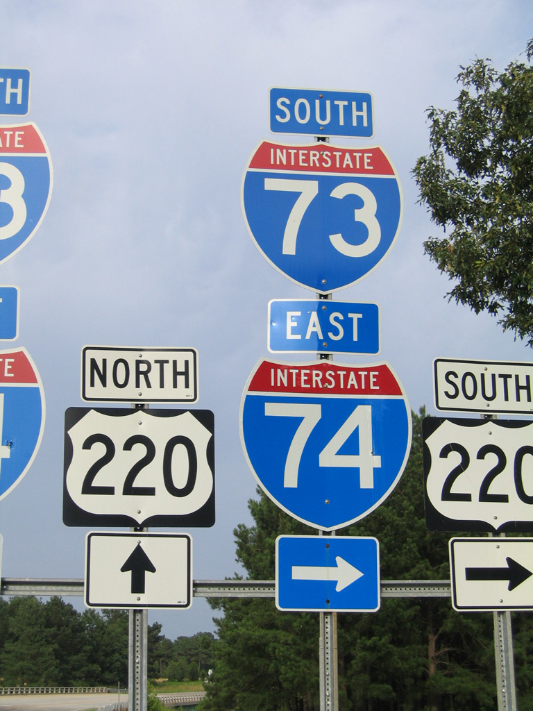
The final confirming marker for I-74 west stands within the median of Interstate 77 beyond milepost 102. The pair advance north 2.9 miles to the Virginia state line, where I-74 formally ends. 09/23/14
![]() East
East ![]() South
South

Interstate 74 appears along side I-77 south just beyond the Virginia state line. Photo by Mike Muiznieks (12/01).

The first in a series of guide signs, since replaced, outline the forthcoming three-wye interchange (Exit 101) for the eastbound split of I-74 from Interstate 77 south. Photo by Jeff Morrison (08/07/05).

Two lanes depart at Left Exit 101 for the 12-mile segment of I-74 east to Mount Airy and U.S. 52. Photo by Jeff Morrison (08/07/05).

Interstate 77 continues south to Statesville and Charlotte while I-74 to U.S. 52 leads southeast toward Winston-Salem. This section of I-74 was signed solely as NC 752 until 2001. Photo by Jeff Morrison (08/07/05).
Sources
- “I-77 Link Means Lost Business, Owners Fear.” Winston-Salem Journal (NC), July 11, 1998.
- “Ready to Road Test Long-Awaited Connector to I-77 is Expected to Open Today.” Winston-Salem Journal (NC), July 1, 1999.
- “Road to the future.” Winston-Salem Journal (NC), March 4, 2013.
- “The Road Less Wantered – Not Everyone Enjoyed the View when a Key Highway Opened from High Point to Winston-Salem 20 Years Ago.” Greensboro News & Record (NC), February 29, 2004.
- “New U.S. 311 Bypass Unveiled.” Greensboro News & Record (NC), September 19, 1997.
- The Real Deal on the New Bypass.” Greensboro News & Record (NC), November 20, 2004.
- “I-74/U.S. 311 bypass opens.” WMBF News, November 22, 2010.
- “Final Section of U.S. 311 Bypass Opens in Randolph County.” North Carolina Department of Transportation, press release. June 7, 2013.
- “U.S. 220 Widened Near Seagrove.” Greensboro News & Record (NC), August 28, 1996.
- I-73 Segment 10/I-74 Segment 11 (Bob Malme)
- SCDOT – Inside SCDOT – Carolina Bays Parkway
http://www.dot.state.sc.us/Projects/CarolinaBays/default.html. SCDOT. - I-74 Segment 16 (Bob Malme)
- “The Drive Behind New Highways.” Sun News (Myrtle Beach, SC), December 18, 2002.
- “Drivers May Cruise To S.C. 544.” Sun News (Myrtle Beach, SC), December 15, 2004.
- “Official: Ground breaking for S.C. 707 widening and S.C. 31 extension to restore faith in the system.” Sun News (Myrtle Beach, SC), November 6, 2013.
- “Re: Interstate 73/74” online posting by bob7374, AARoads Forum, February 26, 2016.
- “Re: Interstate 73/74” online posting by bob7374, AARoads Forum, November 19, 2015.
- “Four New Projects for Division 8 in Updated Draft Transportation Plan.” North Carolina Department of Transportation (NCDOT), news release. June 29, 2017.
- “State Continues to Improve U.S. 74 in Robeson County.” North Carolina Department of Transportation (NCDOT), news release. November 2, 2017.
- “Carolina Bays Parkway Extension study begins.” StarNews (Wilmington, NC), September 13, 2017.
- “Construction Starting on Additional Section of Northern Beltway.” North Carolina Department of Transportation (NCDOT), news release. December 6, 2017.
- “Re: Interstate 73/74” online posting by bob7374, AARoads Forum, December 21, 2017.
- “Re: Interstate 73/74” online posting by bob7374, AARoads Forum, January 8, 2018.
- “First Section of Winston-Salem Northern Beltway Set to Open.” North Carolina Department of transportation (NCDOT), news release. September 4, 2020.
- “Last segment of Carolina Bays Parkway opens.” Associated Press, November 9, 2019.
- “U.S. 311 to High Point is going away (but don’t worry drivers, an interstate is taking its place).” Winston-Salem Journal (NC), June 27, 2019.
- “New Section of Winston-Salem Northern Beltway Set to Open.” North Carolina Department of Transportation (NCDOT) press release. December 22, 2020.
- “US 74 interchange almost done.” The Robesonian (NC), August 6, 2019.
Page updated April 12, 2023.