Interstate 495 New York


Interstate 495 (Long Island Expressway) advances east from Elmhurst in Queens to 108th Street at Corona and Grand Central Parkway and I-678 (Van Wyck Expressway) at Flushing Meadows Corona Park. 12/17/17
Overview
Interstate 495 in New York is the Long Island Expressway, or the L.I.E. to locals. Per the Official Description of Highway Touring Routes, etc. in New York State,1 I-495 is a split route from the Queens-Midtown Tunnel to I-278 (Brooklyn Queens Expressway [BQE]) and from I-678 (Van Wyck Expressway) east to New York Route 25 at Riverhead. The portion of the LIE in between is referenced as New York Route 495.
The Long Island Expressway between the BQE and Van Wyck Expressway was constructed with six overall lanes without Interstate Construction (IC) funding. It was added to the Interstate System in September 1955. Additional lanes were approved for the route by the Federal Highway Administration (FHWA) in 1963. This outlined a ten lane concept, with four elevated lanes above the six lane mainline as adopted in the 1968 Interstate Cost Estimate.2
Governor Hugh L. Carey and Mayor Edward I. Koch jointly requested the withdrawal of a 4.7 mile long section of the LIE from the Interstate System on January 4, 1979 based on the additional elevated lanes. Secretary Brock Adams approved the withdrawal on June 29, 1979, reducing the unobligated balance of IC funds of New York by $14.5 million.1
Despite the official mileage for Interstate 495 not including the portion of the LIE between the BQE and Van Wyck, I-495 is fully signed along the entire length of the Long Island Expressway.
 History
When first proposed in New York, Interstate 495 extended east from the Lincoln Tunnel across the Hudson River into Midtown Manhattan in New York City. Following the planned Mid Manhattan Expressway, I-495 was to connect with the Queens-Midtown Tunnel and continue east along the Queens Midtown Expressway and Horace Harding Expressway to the Clearview Expressway (I-78) in Queens, New York. I-495 would then turn northward along the Clearview Expressway and over the Throgs Neck Bridge. I-495 would split into branches along the Throgs Neck Expressway north to I-95 (New England Thruway) and the Cross Bronx Expressway Extension west to I-95 (Cross Bronx Expressway) at the exchange with I-278 (Bruckner Expressway) and I-595 (Hutchinson River Expressway.
I-495 was part of the urban Interstate numerology for New York submitted approved by the American Association of State Highway Officials (AASHO) on November 10, 1958. The New Jersey State Highway Department previously submitted I-195 as the designation for the route leading east to the Lincoln Tunnel before concurring with the AASHO recommendation for a continuous I-495. The State of New York reviewed changes made by the AASHO route numbering and amended Interstate 78 to replace I-495 northward from the Horace Harding Expressway. AASHO concurred with this change on February 5, 1959.
A controversial roadway, the Mid Manhattan Expressway was never built, leaving I-495 as a discontinuous route between Union City, New Jersey and Queens, New York. The I-495 designation was deleted west of I-278 (Brooklyn Queens Expressway) to the Lincoln Tunnel by the AASHO U.S. Route Numbering Subcommittee on June 23, 1969.
The last section of I-495 opened to traffic was the segment between Exit 71 (eastern NY 24) and Exit 73. Finished in the early 1970s, construction took about 15 years to complete. Prior to 1983, the Long Island Expressway east of Exit 27 (Clearview Expressway) was signed as New York State Route 495. The New York Congressional legislation led by Senator Alfonse D’Amato (R-NY) passed legislation at that time extending Interstate 495 east from the interchange with I-295 (Clearview Expressway) to the end of the expressway at Riverhead.
Route Information
East End – Riverhead, NY
West End – New York, NY
Mileage – 66.38
Cities – New York City, Albertson, Jericho, Plainview, Melville, Hauppauge, Ronkonkoma, Islip, Holbrook
- Junctions –

Source: December 31, 2021 Interstate Route Log and Finders List
I-495 Annual Average Daily Traffic (AADT)
| Location | Vehicles per day |
|---|---|
| Queens Midtown Tunnel | 79,569 |
| Queens | 216,658 |
| Lake Success | 200,522 |
| Jericho | 187,556 |
| Brentwood | 176,294 |
| Ronkonkoma | 170,415 |
| Medford | 116,842 |
| Calverton | 23,253 |
Source: 2019 AADT NYSDOT Traffic Data Viewer

Trailblazers for I-495, NY 25 and CR 58 direct motorists eastward along Tanger Mall Drive from the Tanger Factory Outlet located beside the east end of the Long Island Expressway. Photo by Douglas Kerr (06/00).
The New York State Department of Transportation (NYSDOT) requested the addition of the Long Island Expressway from I-295 (Clearview Expressway) at Exit 27 to Exit 71 at Calverton in Suffolk County to the Federal Highway Administration (FHWA) under the provisions of 23 U.S.C. 139(a). The FHWA concurred that it was a logical addition to the Interstate System in a letter to NYSDOT on October 25, 1983, further adding that the eastern terminus of I-495 should be at Exit 73 / NY 25. The revised route description was:
From the New York-New Jersey State line to the West Side Expressway (I-478) in Manhattan; from the east side of Manhattan, easterly via the Queens-Midtown Tunnel to the Brooklyn-Queens Expressway (I-295); and from I-678 (Van Wyck Expressway), easterly to State Route 25 at Exit 73.
The American Association of State Highway and Transportation Officials (AASHTO) approved the extension on May 24, 1984.
The New Jersey Department of Transportation previously received approval from the FHWA to eliminate I-495 from I-95 to Pleasant and Park Avenue at Weehawken Township in 1979. When I-478 along Westway was withdrawn from the Interstate System, it isolated the short segment of I-495 through the Lincoln Tunnel from the rest of the Interstate System. Actions by the FHWA removing I-478 also deleted all of I-495 west from I-478 under the provisions of 23 U.S.C. 103(f). The application formally eliminating I-495 from the West Side Expressway (I-478) west to the New Jersey state line was approved by AASHTO on June 10, 1986.
There was also occasional discussion of extending the Long Island Expressway along the North Fork of Long Island, and possibly even across Long Island Sound to New London, Connecticut, or Watch Hill, Rhode Island. Proving to be very controversial, those efforts to plan and construct such a link failed to gain traction due to local efforts to preserve the rural character of Long Island’s East End.

Traveling through the Hamptons on eastern Long Island, Interstate 495 (Long Island Expressway [LIE]) takes on a rural feel with fewer trappings of urban society than the west end of the route in Manhattan. 06/13/05
 Photo Guides
East End  – Riverhead, New York
![]() East at
East at ![]()

The final two exits along Interstate 495 east connect with NY 25 and CR 58 (Old Country Road). NY 25 leads four miles east to the Riverhead town center. 05/30/22

The Long Island Expressway concludes at a partially built interchange with CR 58 (Old Country Road) in 0.75 miles. 05/30/22

A half cloverleaf interchange (Exit 72) connects the Long Island Expressway with NY 25 (W Main Street) to Riverton and Calverton. 05/30/22

I-495 narrows to a single lane east from NY 25 to CR 58 (old Country Road) and Tanger Mall Drive at Exit 73. 05/30/22

CR 58 (Old Country Road) runs across the north side of Riverhead along a commercial arterial, bypassing NY 25 south to the town center en route to Greenport and Orient. 05/30/22

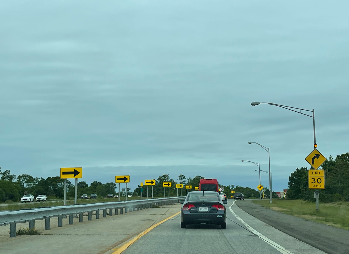
A series of regulatory signs precede the eastern end of the Long Island Expressway. 05/30/22
The stubs at the east end of the Long Island Expressway were built for a 13 mile extension east to Mattituck proposed in 1969. Photo by Peter Johnson (06/12/21).
![]() West at
West at ![]()

CR 58 (Old Country Road) converges with NY 25 (River Road) at a wye interchange just west of Interstate 495 en route to Calverton. 05/30/22

A loop ramp forms the westbound beginning of Interstate 495 (Long Island Expressway) from Suffolk County Route 58 (Old Country Road) west at Riverhead. 05/30/22
![]() East at
East at ![]()

NY 25 shifts south onto River Road and Main Street from a wye interchange with CR 58 (Old County Road) leading into the half cloverleaf interchange with Interstate 495 west. 05/30/22

Interstate 495 west ends Queens, New York 56 miles west from the exchange with NY 25 (Main Street) in Calverton. 05/30/22
West End – Queens-Midtown Tunnel – Astoria, Queens, New York
![]() West at Queens-Midtown Tunnel
West at Queens-Midtown Tunnel

Interstate 495 leads west into the Queens-Midtown Tunnel, which connects with 34th and 39th Streets at Midtown Manhattan. Photo by Jim K. Georges (07/98).
FDR Drive north at E 34th St to ![]()
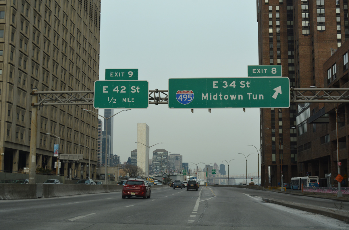
Exit 8 departs from FDR Drive north onto an adjacent service road to E 34th Street to the Queens-Midtown Tunnel (I-495). 12/17/17

The slip ramp for 34th Street joins the FDR Drive service road across from E 26th Street, 0.6 miles from the east entrance to the Queens-Midtown Tunnel. 12/17/17

FDR Drive continues north over E 34th Street and the Queens-Midtown Tunnel to the Upper East Side. 12/17/17

A signalized turn links FDR Drive north with E 34th Street west as part of the Breezewood connection with Interstate 495 east. 12/17/17
E 34th St at Tunnel Approach St to ![]()

Tunnel Approach Street stems north from E 34th Street to the Queens-Midtown Tunnel beyond E 36th Street. The tolled tunnel crosses the East River to Long Island City and Hunters Point in Queens. 12/17/17

Tunnel Approach Street leads two blocks north from E 34th Street to an entrance for the Queens-Midtown Tunnel in Manhattan. An additional entrance is located at 39th Street. Photo by Kevin Lagasse (05/27/01).
E 34th St at Tunnel Approach St to ![]()

2nd Avenue south connects with the Queens-Midtown Tunnel entrance at E 36th Street in the Murray Hill neighborhood of Manhattan, New York. Photo by Peter Johnson (06/12/21).
![]() Queens-Midtown Tunnel – East
Queens-Midtown Tunnel – East

Traffic from 2nd Avenue, 36th Street and Tunnel Approach Street consolidates to two lanes leading into the Queens-Midtown Tunnel eastbound below 1st Avenue. Photo by Peter Johnson (06/12/21).
Sources:
https://www.dot.ny.gov/divisions/operating/oom/transportation-systems/repository/2012 tour-bk.pdf- “The Dwight D. Eisenhower System of Interstate and Defense Highways,” Part V – Interstate Withdrawal-Substitution Program.
Page updated June 7, 2022.