Interstate 471 Kentucky / Ohio

Overview

Initially opened in 1977, the Daniel Carter Beard Bridge carries Interstate 471 between Newport, Kentucky and Cincinnati, Ohio. The Big Mac Bridge spans U.S. 52 above the north shore of the Ohio River in this scene. Photo by Steve Hanudel (07/03/06).
Interstate 471 constitutes an urban connector linking I-275 (Circle Freeway) in Northern Kentucky with I-71 in Cincinnati, Ohio. The six lane freeway winds through the suburban cities of Southgate and Fort Thomas and separates urban areas of Newport and Bellevue to the Daniel Carter Beard Bridge. The eight lane tied arch bridge crosses the Ohio River into Cincinnati at the Mt. Adams neighborhood outside Downtown.
 History
Interstate 471 was part of the proposed urban numerology for both the Kentucky and Ohio Interstate systems approved by the American Association of State Highway Officials (AASHO) on November 10, 1958. The loop was initially referenced by the state of Ohio as Interstate Route A-71 in March 1958, and then in conjunction with Kentucky as Interstate 271. AASHO changed the route to I-471, as I-271 was assigned to Cleveland.
Interstate 471 was envisioned in 1961 as an east to west connector between I-71/75 in Covington, Kentucky and I-71 in Cincinnati, Ohio. Referenced as the Riverside Expressway, it would have provided an alternative to Interstate 71 and formed an inner loop roadway system. The course envisioned for the route straddled the Ohio Riverfront north of the 4th Street Bridge, between Covington and Newport, to a proposed crossing of the river east of the L&N Bridge. A March 29, 1961 Kentucky Post article referenced the proposed Riverside Expressway as Interstate 471. The mayors of both Covington and Newport and area residents quickly expressed opposition to the highway.1
With the Riverside Expressway dropped, a new proposal arose in Summer 1962 for a freeway spur linking Newport with the planned Circle Freeway (I-275) to the south at Highland Heights. Related actions approved the route of I-275 across Northern Kentucky in March 1963, but kept the $26 million spur route for I-471 under review.1
Connecting I-275 at Highland Heights with Newport and I-71 in Cincinnati, a map released on December 10, 1967 outlined a 4.8 mile corridor for I-471. The bulk of this route follows modern day Interstate 471, with the exception of exit ramps at Newport, which were still debated at the time. Right of way acquisition for around 529 parcels needed for the roadway began in January 1968. Bidding for construction of the Ohio River bridge got underway in Fall 1970.1,2
The tied arch bridge between Newport and Cincinnati was constructed between November 1971 and September 1976. It was named October 5, 1976 after Daniel Carter Beard, the founder of the Boy Scouts who grew up in Northern Kentucky. The 2100 foot long span and a short section of I-471 were dedicated on February 14, 1977. The Ohio River crossing is generally referred to as the Big Mac Bridge because its yellow paint scheme resembles the golden arches of McDonald’s restaurants.2
While bridge work was ongoing, delays for the connecting freeway continued. Land acquisition issues arose between the state and the Newport Board of Education over a site needed for I-471 that was slated for a vocational school. Newport residents also voiced concerns about the loss of houses and potential pollution. The ramp controversy in Newport also remained a contested issue. Proposals by 1977 called for a northbound exit to 4th Street, a southbound exit to Riverside Drive and entrance ramps from 3rd and 5th Streets.1
The Newport School board eventually agreed to sell land off Grand Avenue and Sixth Street for the freeway in August 1977. A temporary connector was also reluctantly agreed upon from the Daniel Beard Bridge and 6th Street at the same time. Work by 1980 added sound barriers along sections of I-471 in Newport and Fort Thomas, while debate continued on the finalized ramp design from the bridge.1
Route Information
Mileage
Kentucky – 5.02
Cities – Highland Heights, Wilder, Southgate, Fort Thomas, Newport, Bellevue
- Junctions –

Ohio – 0.73
Cities – Cincinnati
- Junctions –

Source: December 31, 2021 Interstate Route Log and Finders List
I-471 Annual Average Daily Traffic (AADT)
Source: 2017 AADT – KYTC Interactive Statewide Traffic Counts Map
2017/18 AADT – ODOT Transportation Data Management System
* AADT for KY 471 recorded in 2015
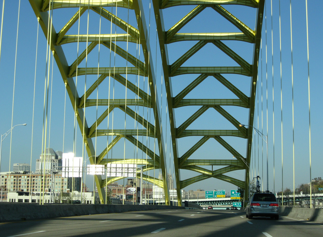
Crossing into Ohio along the Dan Beard Bridge on Interstate 471 north. The main span of the tied arch bridge is 750 feet in length. 11/08/09

The Dan Beard Bridge was the only portion of I-471 under construction by 1973. Work further north was complicated by the landslide at Mt. Adams while the final alignment for I-471 south from Newport was still contested. Note also that the Fort Washington Way section of I-71 along the Cincinnati Riverfront was drastically overhauled during a multi-year project completed in 2000.
Construction of I-471 in Cincinnati, Ohio was not without difficulties as well. A landslide occurred in 1973 during construction of the road at the Mt. Adams neighborhood. The incident resulted in the city and state buying many of the properties damaged and requiring the relocation of 32 businesses and 330 or so families.3 Ensuing construction between 1980 and 1985 added a complex retaining wall to prevent future earth movements.4
161 vertical concrete pilings reinforced with structural steel were installed at the base of Mt. Adams for the I-471 retaining wall. Bundles of cable held 137 of the pilings in place against the gravitational force of the hill. With the added wall, costs for the one mile section of I-471 in Ohio increased to $48 million, which at the time was the most expensive mile of freeway in U.S. history.4
Interstate 471 opened to traffic on December 22, 1980 between KY 1820 (Grand Avenue) and U.S. 27 at Highland Heights. An additional section opened the following day between Memorial Parkway and the Beard Bridge. Work on the freeway culminated September 18, 1981, when Governor John Y. Brown spoke at a dedication ceremony for the opening of I-471 between Grand Avenue and Memorial Parkway.1 Final costs in 1981 for the bridge and freeway were $85 million.2
Permanent ramps at Newport would remain a hot topic until they were finally built between April 1988 and August 1989. During this time period, a truck ban was also instituted along I-471 by Governor Martha Layne Collins. The restriction ran from July 1986 and May 1988, when actions by the Federal Highway Administration (FHWA) lifted it.1
The freeway spur south from I-275 to U.S. 27 is unsigned KY 471. KY 471 was designated on June 1, 1990, when the section of Interstate 471 between U.S. 27 and Interstate 275 was removed from the Interstate Highway System.5
 Photo Guides
North End  – Cincinnati, Ohio
![]() North at
North at ![]()
![]()

The entrance ramp from KY 8 (Dave Cowens Drive) at the Newport riverfront adds an auxiliary lane to Interstate 471 north across the Daniel Carter Beard Bridge into Cincinnati. 11/08/09
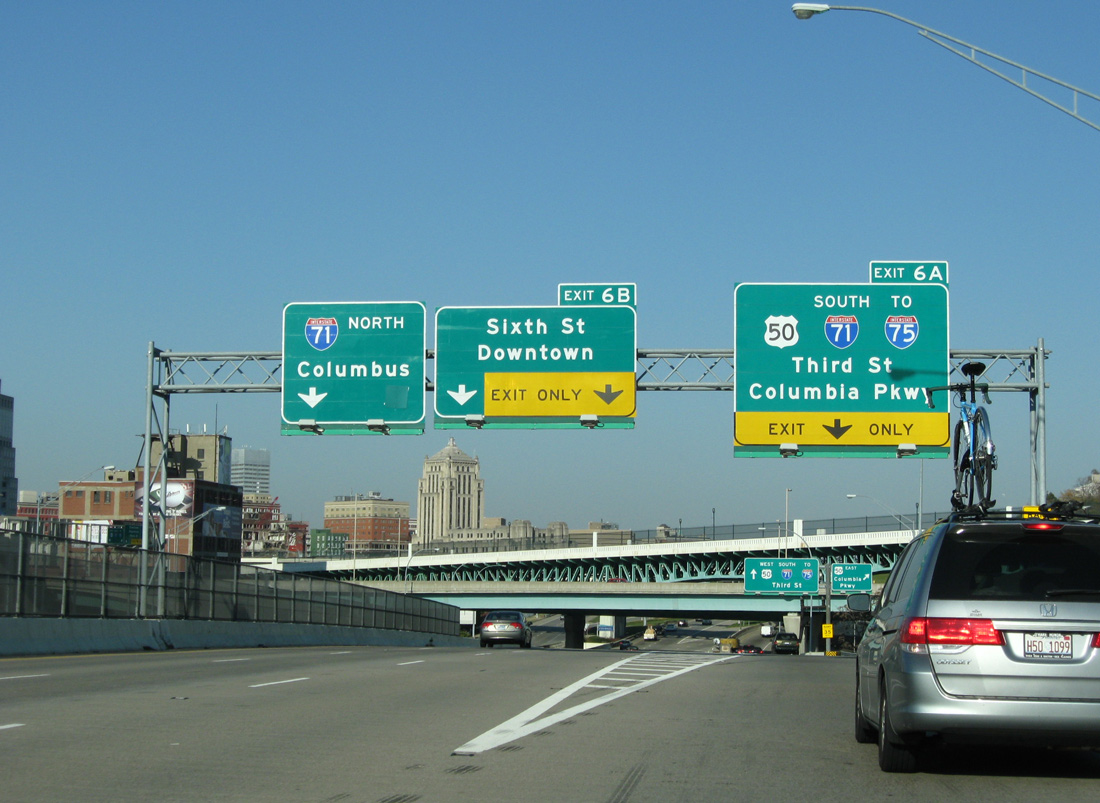
Continuing from the Big Mac Bridge, Interstate 471 partitions into ramps for U.S. 50 (Columbia Parkway) west to I-71 south (Exit 6A), Sixth Street to Downtown Cincinnati and I-71 north to the Avondale and Walnut Hills neighborhoods. 11/08/09
![]() South at
South at ![]()

Exit 2 separates from southbound Interstate 71 for parallel U.S. 42 (Reading Road) and U.S. 22 (Gilbert Avenue) just ahead of I-471. 11/08/09

A series of overpasses, including Elsinore Place and U.S. 22 (Gilbert Avenue), span I-71 south ahead of the wye interchange with Interstate 471. 11/08/09

Interstate 471 branches south from I-71 at an unnumbered ramp to the Daniel Beard Bridge to Newport, Kentucky. I-71 lowers through the Lytle Park Tunnel ahead of the 3rd Street exit into Downtown Cincinnati. 11/08/09
![]() East at
East at ![]()
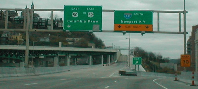
U.S. 50 (Columbia Parkway) splits with I-71 north and connects with Interstate 471 south to Newport, Kentucky. Columbia Parkway continues east to Hyde Park and U.S. 52 by Cincinnati Municipal Airport-Lunken Field (LUK). Photo by Shawn De Cesari/Dan Moraseski (11/01).
![]() West at
West at ![]()
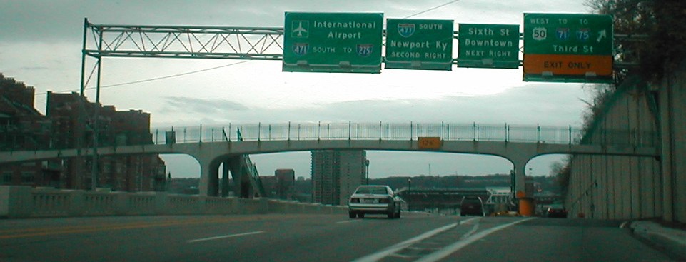
Westbound U.S. 50 separates with Columbia Parkway for 3rd Street into Downtown Cincinnati just ahead of I-471. The parkway elevates along a viaduct west to succeeding ramps with Sixth Street, I-471 south and Pike Street above the Lytle Park Tunnel (I-71). Photo by Shawn De Cesari/Dan Moraseski (11/01).
Fifth Street – East at ![]()

Fifth Street ties into ramps for I-71 north, I-471 south and the Columbia Parkway viaduct east to U.S. 50. The preceding left turn leads to Sentinel Street, which runs alongside the Proctor and Gamble buildings, a popular spot for news crews to do live reports on highway conditions during winter. Photo by Jeremy Moses (04/04/08).
South End 
 – Highland Heights, Kentucky
![]() South at
South at ![]()
![]()

An S-curve leads Interstate 471 south through a valley between Wilder and Fort Thomas to the multi level exchange with I-275 (Circle Freeway) and KY 471. Photo by Eric Stuve (10/11/15).

The succeeding ramp (Exit 1B) departs for I-275 west to Taylor Mill, Fort Wright and Cincinnati/Northern Kentucky International Airport (CVG). Photo by Eric Stuve (10/11/15).

Interstate 275 winds west 8.6 miles from I-471 to the systems interchange with I-71/75 in the city of Erlanger. Photo by Carter Buchanan (11/04/04).
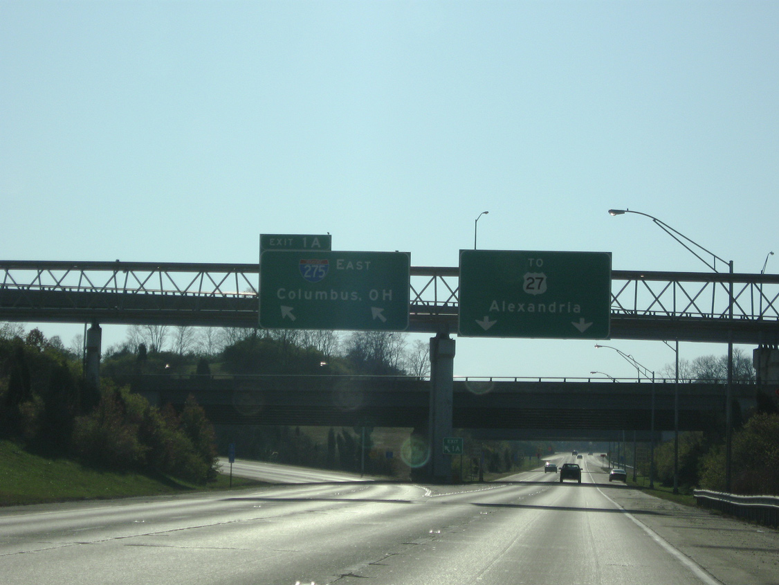
Left Exit 1A connects with Interstate 275 (Circle Freeway) east across the Combs-Hehl Bridge to California in southeast Cincinnati. 11/08/09
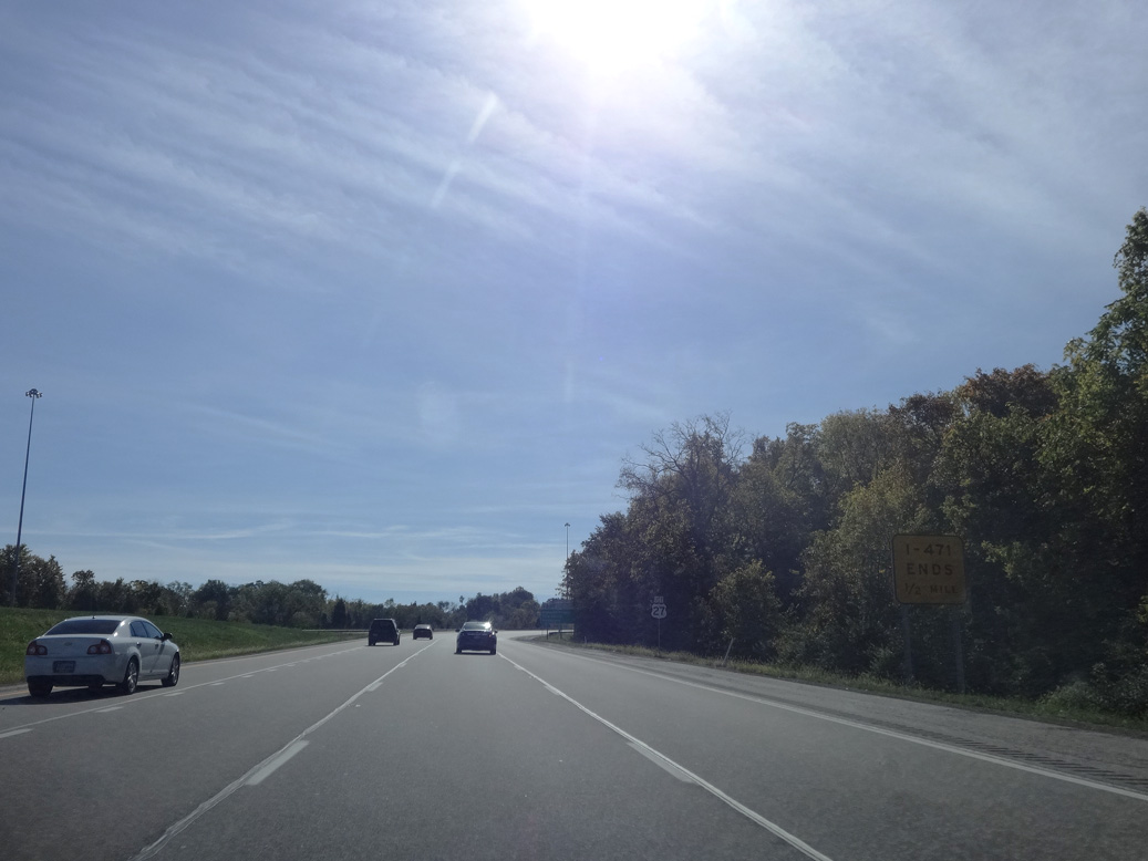
The zero milepost for I-471 stands at the entrance ramps from Interstate 275. Unsigned KY 471 extends 0.70 miles south to U.S. 27 at Highland Heights. Photo by Eric Stuve (10/11/15).
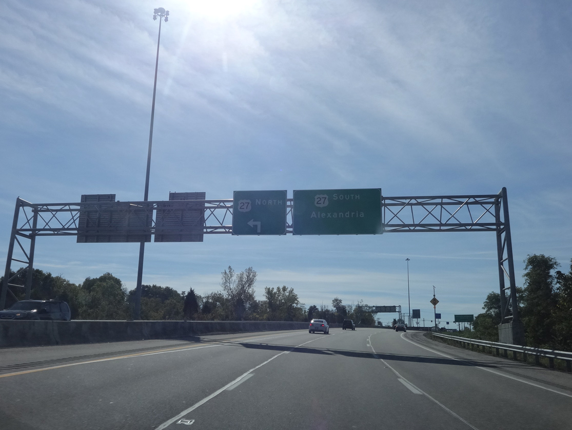
Continuing south on KY 471, the freeway concludes at a signalized intersection with U.S. 27 (Alexandria Pike) north to Fort Thomas and south to Cold Spring. Photo by Eric Stuve (10/11/15).
![]() North at
North at ![]()
![]()

U.S. 27 (Alexandria Pike) turns east at the south end of KY 471 in Highland Heights to Fort Thomas. Unsigned KY 471 extends 0.70 miles north to become Interstate 471 at I-275 (Circle Freeway). Photo by Shawn De Cesari/Dan Moraseski (11/01).

KY 471 advances north to the four-wye interchange (Exit 1) with I-471 north and Interstate 275 (Circle Freeway). Photo by Eric Stuve (10/11/15).

KY 471 advances north to the four-wye interchange (Exit 1) with I-471 north and Interstate 275 (Circle Freeway). Photo by Eric Stuve (10/11/15).

Left Exit 1B follows for I-275 west to I-71/75 at Erlanger and U.S. 25-42-127 (Dixie Highway). Photo by Eric Stuve (10/11/15).

Interstate 471 heads north from the exchange with I-275 into the city of Southgate. Photo by Eric Stuve (10/11/15).
![]() North at
North at ![]()
![]()

I-275 curves northward from the exchange with KY 9 (Licking Pike) to Three Mile Road (KY 2238) at Northern Kentucky University and I-471 at Exit 74. Photo by Eric Stuve (07/31/16).

Interstate 471 extends 5.02 miles north from I-275 to the Ohio line on the Daniel Carter Beard Bridge. KY 471 continues the freeway south 0.70 miles to U.S. 27 (Alexandria Pike). Photo by Eric Stuve (07/31/16).

The adjacent ramp at the half diamond interchange (Exit 76) with KY 2238 (Three Mile Road) measures 0.667 miles in length. Left Exit 74B to I-471 departs to the immediate north. Photo by Eric Stuve (07/31/16).

Interstate 275 (Circle Freeway) north at the three level interchange (Exit 74) with I-471 north and KY 471 south. Photo by Eric Stuve (07/31/16).
Sources:
- “I-471’s birth slow to come – Plans and routes changed many times.” The Kentucky Post (Covington, KY), November 30, 1998.
- “Change in direction: East-west route along riverfront once envisioned for Interstate 471.” Cincinnati Post (OH), May 9, 2005.
- “Mt. Adams Project Put on Hold – City Needs Approval of Next Governor.” Cincinnati Post (OH), October 25, 1990.
- “Holding Back Mt. Adams – Retaining Wall Needs Mending – Three Cables Have Lost Tension.” Cincinnati Post (OH), June 1, 1990.
- Dan Moraseski provided information regarding the establishment of Kentucky 471.
Page updated July 22, 2021.