Interstate 464 Virginia

Overview
Interstate 464 is a mostly six lane urban connector linking I-64, U.S. 17 and SR 168 in Chesapeake with I-264 and the tolled Downtown Tunnel at Berkley in Norfolk. I-464 links directly with SR 168 and the Chesapeake Expressway, a limited access toll road southward to the North Carolina State line and the Outer Banks.
 History
Interstate 464 opened between I-64 and U.S. 13 (Military Highway) in May 1967. The freeway was extended north from Military Highway to SR 337 (Poindexter Street) in July 1987.1
The northernmost portion of Interstate 464 was opened to northbound traffic as part of the Berkley interchange project along I-264 in Norfolk. Work along I-264 doubled capacity at the adjacent Downtown Tunnel to the west while expanding the interchange with I-464. A ceremony preceded the reopening of the 1952 tunnel, which was renovated for a year, on December 20, 1988.2
Work along the Berkeley Bridge, the movable span linking Chesapeake with Downtown Norfolk via Interstate 264, continued to May 24, 1990. Opening at that time was the second span for eastbound traffic, which serves departing traffic from I-464 north. The $41 million project also focused on refurbishing the original 1952 bridge, which was switched to westbound traffic for I-264.3 The westbound Berkley Bridge closed for a year starting on October 19, 1990.3 It reopened on June 27, 1991.4
Tying into the south end of Interstate 464 is the Oak Grove Connector, a limited access link between the Hampton Roads Beltway and the Great Bridge Bypass. Designated as State Route 168, the Oak Grove Connector opened northbound in May 1999 and southbound after a ribbon cutting ceremony held on July 22, 1999. Planned since the 1960s, $38 million in construction on the connector commenced in August 1997.5
Further south, the 10.2 mile long Chesapeake Expressway extends the high speed route of SR 168 to North Carolina. Costing $116 million and built by the Public Private Transportation Act, construction on the toll road broke ground on July 12, 1999.6 The expressway opened following a ceremony held on the morning of May 23, 2001.
Route Information
North End – Norfolk, VA
South End – Chesapeake, VA
Mileage – 4.71
Cities – Chesapeake, Norfolk
- Junctions –


Source: December 31, 2021 Interstate Route Log and Finders List
I-464 Annual Average Daily Traffic (AADT)
Source: 2021 AADT VDOT Traffic Volume

SR 337 west from I-464 spans the Southern Branch of the Elizabeth River across the tolled Jordan Bridge. Opened to traffic on October 29, 2012, a fixed 165 foot high span replaced the original draw bridge there. Construction included the elimination of the loop ramp from I-464 south to SR 337 east.
 Photo Guides
North End  – Norfolk, Virginia
![]() North at
North at ![]()

Interstate 464 north ended at the cloverleaf interchange (Exit 4) with SR 337 (Poindexter Street) until 1987. 12/14/17

Interstate 464 winds northwest to I-264 across D Street, a Norfolk Southern Railroad line and Halifax Street by port and industrial areas along the Elizabeth River Southern Branch. 12/14/17

A second pair of end signs appear for Interstate 464 at the half diamond interchange (Exit 5) with S Main Street. 12/14/17

Exit 6A departs I-464 north well ahead of the interchange with Interstate 264. The off-ramp links with adjacent State Street and Berkley Avenue before looping into the Downtown Tunnel to Portsmouth. 12/14/17

I-464 north defaults onto the Berkley Bridge and Interstate 264 east to Downtown Norfolk. Two lanes merge from the Downtown Tunnel beyond an end shield. 12/14/17
![]() West at
West at ![]()

U.S. 460 Alternate combines with I-264 south from Downtown Norfolk across the Berkley Bridge ahead of the split with Interstate 464 at Exit 8. 12/14/17

The Berkeley Bridge westbound carries four lanes of traffic across the Elizabeth River Eastern Branch to the exchange with Interstate 464 south. 12/14/17

Ramps depart simultaneously for both Interstate 464 south to Chesapeake, Berkley Avenue to SR 337 (S Main Street) and an inspection station for vehicles carrying hazardous materials through the tolled Downtown Tunnel. 12/14/17
![]() East at
East at ![]()
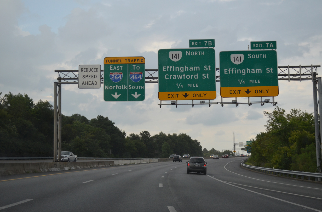
The last exit before the tolled Downtown Tunnel on Interstate 264 east is with SR 141 (Effingham Street) by Downtown Portsmouth. The succeeding exit is for I-464 south. 07/28/13

An All Electronic Toll (AET) gantry precedes the I-264 eastbound descent into the Downtown Tunnel at Court Street. The two lane tunnel emerges at Exit 8 for I-464 south. 07/28/13
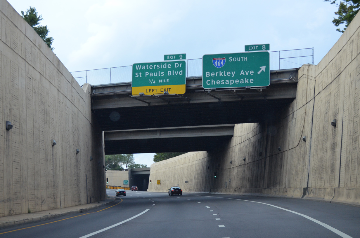
Exit 8 loops away from I-264 east to Interstate 464 south to the city of Chesapeake. I-264 east next spans the Berkley Bridge into Downtown Norfolk. 07/28/13

Exit 8 partitions with a slip ramp joining the off-ramp from I-264 west to Berkley Avenue before continuing onto Interstate 464 south. 07/28/13
North End Throwback

Interstate 464 crosses the Norfolk/Chesapeake city line at the D Street underpass a half mile south of Exit 5. This set of signs was replaced after 2008. 12/17/01

S Main Street links I-464 with the Norfolk Naval Shipyard and adjacent SR 337 (Bainbridge Boulevard) at Berkley. This sign bridge was replaced after 2008. 12/17/01

Two lanes continue onto I-264 east to Downtown Norfolk beyond the departure of Exit 6 A for I-264 west and parallel State Street near Washington Point. 12/17/01
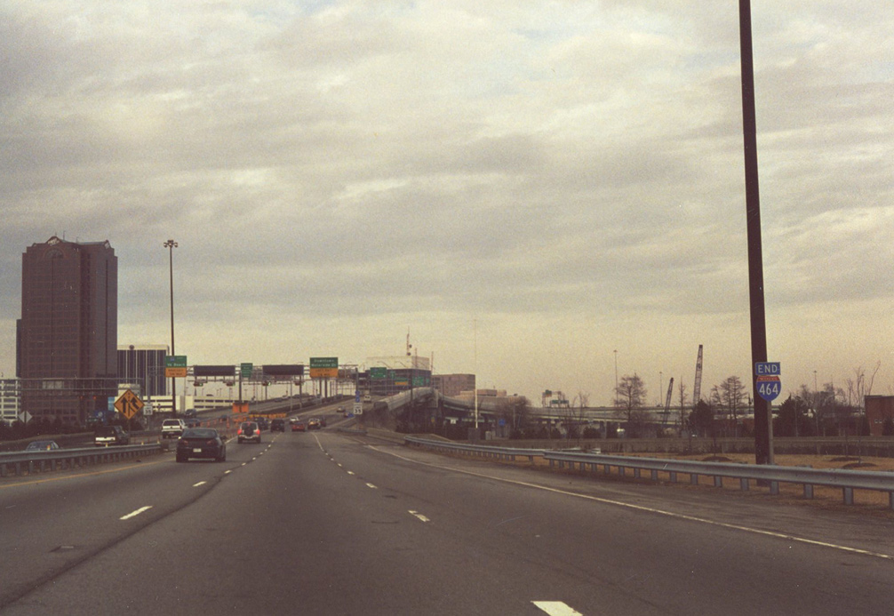
Interstate 464 north at I-264 east ahead of the Berkley Bridge. 12/27/00
South End 
 – Chesapeake, Virginia
![]() South at
South at ![]()
![]()
![]()

I-464 meets U.S. 13 (Military Highway) at a diamond interchange (Exit 2) one mile from I-64, U.S. 17 and SR 168. The exchange with U.S. 13 was partially open between 1967 and 1987. 07/28/13

Campostella Road spans Interstate 464 one quarter mile north of the cloverleaf interchange (Exits 1B/A) with I-64 and U.S. 17/SR 168. 07/28/13

Exit 1B takes motorists from I-464 south onto I-64/U.S. 17 north across the high rise bridge over the Southern Branch of the Elizabeth River to Deep Creek. 07/28/13

Interstate 64 arcs northeastward to I-264 at Virginia Beach then northwest through Norfolk and Hampton. U.S. 17 branches southwest along Dominion Boulevard and the toll bridge spanning the Elizabeth River. 12/30/17

Traffic separates at the south end of I-464 for U.S. 17 southwest to Elizabeth City, North Carolina and SR 168 (Oak Grove Connector) south to Great Bridge and the tolled Chesapeake Expressway to Moyock. Construction between 2013 and 2017 upgraded U.S. 17 to limited access standards from SR 168 to SR 165 (Cedar Road). 12/30/17
![]()
![]() North at
North at ![]()
![]()

U.S. 17 (Dominion Boulevard) converges with SR 168 (Oak Grove Connector) just ahead of the cloverleaf interchange with I-64/464. 12/14/17

U.S. 17 shifts from Dominion Boulevard onto Oak Grove Connector at a trumpet style interchange with SR 168 south. SR 168 north dog legs east along I-64 to Battlefield Boulevard at Exit 290. 12/14/17

2013-17 construction upgraded U.S. 17 along Dominion Boulevard north from SR 165 (Cedar Road) at Deep Creek South to an expressway north to SR 168 and I-464. This expressway is part of the Future I-87 corridor southwest to Raleigh, North Carolina. 12/14/17

A left side entrance ramp brings U.S. 17 north onto the northbound beginning of Interstate 464. 12/14/17

A loop ramp (Exit 1) takes U.S. 17 north from I-464 onto Interstate 64 west toward Deep Creek and Suffolk. I-64 concludes 8.4 miles to the west at Bowers Hill. 12/14/17
![]()
![]() South at
South at ![]()
![]()

SR 168 south merges onto Interstate 64 from a c/d roadway within a half mile of Exit 291A for I-464 north. 12/30/17

I-464 connects Downtown Norfolk with central areas of Chesapeake and the area of Great Bridge of south of Interstate 64. 12/30/17

Long range plans (mid 2030s) widening I-64 from six to eight lanes will include improvements at the cloverleaf interchange (Exit 291) with Interstate 464.8 12/30/17
![]()
![]() South at
South at ![]()
![]()

Construction underway from Summer 2018 to December 2022 builds a new High Rise Bridge for eastbound traffic along I-64. The $409.6 million project widens nine miles of I-64 from I-264 to a point 0.9 miles east of I-464. 12/14/17

A collector distributor roadway departs ahead for SR 168 south to Great Bridge, I-464 north to Norfolk and SR 168 Business (Battlefield Boulevard). 12/14/17

Construction in 2007 extended the c/d roadway from Interstate 464 east to SR 168 Business (Battlefield Boulevard). U.S. 17 south is discontinuous here, as there is no access to Dominion Boulevard from Exit 291B. 12/14/17

I-464 runs north parallel to the Southern Branch of the Elizabeth River through Portlock and Avalon to Berkley in Norfolk. 12/14/17
South End Throwback

When the Oak Grove Connector extended SR 168 northward to directly tie into Interstate 464, an interchange with U.S. 17/old SR 104 was constructed. 12/27/00

U.S. 17 was realigned onto Dominion Boulevard leading northeast from Great Dismal Swamp in Winter 2002. Overtaking former SR 104, this was done as part of an overall realignment from North Carolina through Deep Creek South in Chesapeake. 12/17/01

The exit numbering system for I-464 commences at the exchange with I-64. Pictured here are guide signs posted before the 2002 relocation of U.S. 17. 12/27/00
Sources:
- I-464, Virginia Highways Project.
- “Downtown Tunnel Officially Reopened after Renovation.” Richmond Times-Dispatch (VA), December 21, 1988.
- “2nd Berkley Bridge Will Open this Morning.” Virginian-Pilot, The (Norfolk, VA), May 24, 1990.
- “Oold Span’s Close May Bring New Confusion.” Virginian-Pilot, The (Norfolk, VA), October 19, 1990.
- “Twice as Nice: At Long Last, It’s B Berkley ‘Bridges,’ Plural.” Virginian-Pilot, The (Norfolk, VA), June 26, 1991.
- “Joy in Chesapeake as Southbound Lanes of Road Set to Open \ Completed Highway is Expected to Take 30 Percent of Traffic from Busy Battlefield.” Virginian-Pilot, The (Norfolk, VA), July 20, 1999.
- “Battlefield Boulevard to Get Relief after 30 Years, Route 168 Bypass Ground Breaking is Today.” Virginian-Pilot, The (Norfolk, VA), July 12, 1999.
- I-64 Southside/High Rise Bridge: FAQS
Page updated April 12, 2023.