Interstate 410 Louisiana

 Baton Rouge
Interstate 410 was originally proposed along a freeway loop through West and East Baton Rouge Parishes. Branching northeast from I-10 near LeJeune, I-410 would have joined U.S. 190 and crossed the Mississippi River Bridge north of Port Allen to Scotlandville in Baton Rouge. Turning south along the Baton Rouge Expressway, I-410 would reconnect with I-10 at the east end of the Horace Wilkinson Bridge.
The western leg of I-410 through West Baton Rouge Parish was subsequently dropped in the early 1960s. The initial stretch of the Baton Rouge Expressway linked East Boulevard in Downtown Baton Rouge with the State Capitol complex and Plank Road (LA 67) north by Memorial Stadium. With it no longer comprising part of a full loop, the urban freeway was renumbered as Interstate 110.
Route Information
Baton Rouge
East End – Baton Rouge, LA
West End – Port Allen, LA
Mileage – 16
Cities – Baton Rouge, Port Allen
- Junctions –

Source: estimate from Google Earth.
New Orleans
East End – New Orleans, LA
West End – Kenner, LA
Mileage – 48
Cities – New Orleans
- Junctions –
Source: Interstate 410 (Kurumi.com)
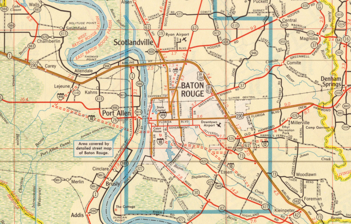
1961 Baton Rouge area map outlining the Interstate 410 urban loop.
New Orleans
The second designation for Interstate 410 in Louisiana was the early 1960s and late 1970s proposed loop around the southern New Orleans metropolitan area. Plans for the highway included two crossings of the Mississippi River along a corridor traversing substantial areas of wetlands. Beginning in St. Charles Parish from I-10, the 48 mile long corridor stayed generally south of Lapalco Boulevard on the Westbank and reconnected with I-10 along Paris Road in New Orleans East.1
Opening of the Greater New Orleans Bridge in 1958 (U.S. 90 Business) provided a conduit for development along the Westbank of the Mississippi River. This allowed New Orleans to expand, which was limited in available land to develop because of the presence of wetlands. Government officials cited that the I-410 bypass was necessary to alleviate growing through traffic in New Orleans. U.S. Representative Hale Boggs was also a proponent of the southern bypass, considering it a potential boon for economic development in Jefferson Parish. Areas along the I-410 corridor were sparsely populated at the time.2
Funds and Interstate mileage for Interstate 410 were allocated from the cancelled Riverfront Expressway (I-310) in the 1960s. The Riverfront Expressway was a previously proposed elevated highway through Downtown and the French Quarter in New Orleans.3 The Louisiana Department of Highways started the I-310 project as the Dixie Freeway. Input from early public hearings generally supported Interstate 410, with disagreement mostly on the corridor locations.2
Three alignments were studied for I-410 near Luling and five in the Chalmette-Meraux study area. Various alternatives were also studied for the crossing over Harvey Canal (Intracoastal Waterway). The corridor ran within two to five miles south of U.S. 90 and Lapaclo Boulevard on the Westbank in Jefferson Parish.2 Within St. Charles Parish, I-410 was projected along an alignment approximately four miles west of Kenner.
An environmental reported from January 8, 1973 cited that restrictions should be placed on wetland reclamation and that future development should be directed to the terrace lands of the Lake Pontchartrain North Shore. Further analysis indicated that the route of I-410 was not practical from an environmental standpoint.4 Draft Environmental Impact Statement (DESIT) traffic counts estimated around 25,000 vehicles per day (vpd) for the route and 55,000 vpd by 1994. These numbers were low for a proposed six lane freeway.2
Further objection to Interstate 410 cited that highway was chiefly a land development corridor with little traffic demand and utility as a bypass route for transcontinental travelers.2 Lack of coordination between highway planners, elected officials and the public ultimately led to the cancellation of I-410.
The corridor for Interstate 410 resurfaced as part of the Louisiana Statewide Transportation Plan Update (December 2003) under project number LSTP-029.1 The project outlined an extension of Interstate 510 to the south and west from New Orleans East.6 However, it was never enacted upon.
Sources
“Interstate 410, A Highway for Few.” from contributor Steven Delery in 2004.
- Interstate 410. 3 digit Interstates at kurumi.com.
- Thomas Lee Osborne, “The Interstate-410 Planning Process: A case study” (master’s thesis, Louisiana State University at New Orleans, 1972), vi.
- The Battle of New Orleans – Vieux Carre Riverfront Expressway (I-310) 27 June 2017.
- Coastal Environmentals, Inc., “Environmental Considerations, Interstate I-410.”
- “Bypass report shows $910 million, 6-phase plan.” Baton Rouge Advocate (LA), October 26, 2004.
- Louisiana Statewide Transportation Plan Update.
http://www2.dotd.louisiana.gov/study/
Page updated February 10, 2019.