Interstate 390 New York
Overview
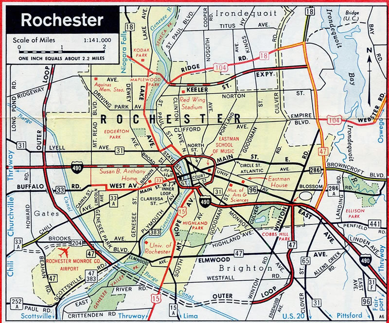
Traveling 76 miles overall, Interstate 390 follows the Genesee Expressway north from the Southern Tier Region of Upstate New York to Rochester’s Outer Loop in the town of Brighton. The scenic freeway winds northwest from Avoca to Dansville, Geneseo and Avon through agricultural land and hilly terrain. North from the Finger Lakes area, I-390 continues to suburban areas of Monroe County, carrying commuters north from West Henrietta to the city of Rochester.
The Genesee Expressway ends at the Outer Loop, having been canceled north from there to Downtown Rochester. Interstate 390 follows the southwestern arc of the Outer Loop to Greater Rochester International Airport (ROC) and I-490 (Western Expressway) in the town of Gates. Interstate 590 lines the southeast quadrant of the Outer Loop, encircling Brighton northeast to I-490 in east Rochester.
The Outer Loop extends north of I-490 on both sides of the city as NY 390 and NY 590 respectively. New York Route 390 travels 7.90 miles from I-390 and I-490 to Lake Ontario State Parkway as a limited access highway.
 History
The Rochester Outer Loop designated as New York Route 47 in 1968.
The Rochester Outer Loop was originally designated New York Route 47. The freeway opened to traffic from the west and east, with the last section south of I-490 joining the two sections where the Genesee Expressway ties in from the south. The oldest segment of I-390 south of Rochester was the Dansville-Wayland Expressway. Built in the late 1960s,1 the short freeway linking NY 21 and NY 36 was numbered as NY 401, then NY 245.2
As construction progressed along both the Genesee Expressway and Outer Loop, the separate segments of state route freeway were incorporated into the Interstate system. Interstate 590 replaced NY 47 in Monroe County and NY 245 became part of I-390 in Livingston County. The remainder of I-390 was completed slowly over the course of 20 years, with the last section opened between NY 15 at Avoca and I-590 in 1981. Some New York State Department of Transportation (NYSDOT) reference markers around Dansville still referenced NY 245 as of January 2017.
Route Information
North End – Rochester, NY
South End – Kanona, NY
Mileage – 76.06
Cities – Rochester
- Junctions –


Source: December 31, 2021 Interstate Route Log and Finders List
I-390 Annual Average Daily Traffic (AADT)
Source: 2015 NYSDOT Traffic Data Viewer
Within Rochester, initial plans for Interstate 390 took the freeway north from the Rochester Outer Loop (I-590) directly to the Rochester Inner Loop (I-490). The proposed alignment of I-390 followed the Genesee River northward from a portion of the University of Rochester campus to neighborhood areas south of central business district. While ramps to the Genesee Expressway were added from the Inner Loop at Downtown, growing community opposition halted additional construction.3
Ultimately the Genesee Expressway project was dropped, with I-390 rerouted over the southwest leg of the Outer Loop in place of I-590. The American Association of State Highway and Transportation Officials (AASHTO) approved the renumbering of Interstate 590 west from the Genesee Expressway to I-490 as I-390 on June 25, 1979. The Outer Loop between NY 383 and Winton Road was finished in December 1980, followed by completion of the route from NY 104 to Lake Ontario State Parkway in 1984. The action included designating the previously unnumbered Outer Loop north to Lake Ontario State Parkway as part of Interstate 390. Despite that, the freeway north of I-490 was instead signed as New York Route 390.
Started in 2016, the I-390/I-490 Interchange Improvement Project made a number of improvements at the exchange joining I-490 with I-390/NY 390 at the town of Gates. Completed in Summer 2018, work on Phase One replaced the NY 31 (Lyell Avenue) bridge over NY 390 with a wider span. Phase Two work through late 2019 rehabilitated bridges along NY 390 over Erie Canal, realigned the entrance ramp from NY 31 onto NY 390 northbound, and added lane capacity. Phase Three constructed a new roadway for NY 390/I-390 southbound through the exchange with I-490. Opened to traffic on September 17, 2021, the flyover eliminated left exit ramps by repurposing the former roadway for NY 390/I-390 south into a collector distributor roadway. Completed by the end of 2021, Phase Four construction widened NY 31 (Lyell Avenue) between NY 390 and Howard Road.4 The $172.8 million project garnered recognition by the American Public Works Association for Transportation Projects Greater on March 25, 2022.5
 Photo Guides
North End 
 – Gates, New York
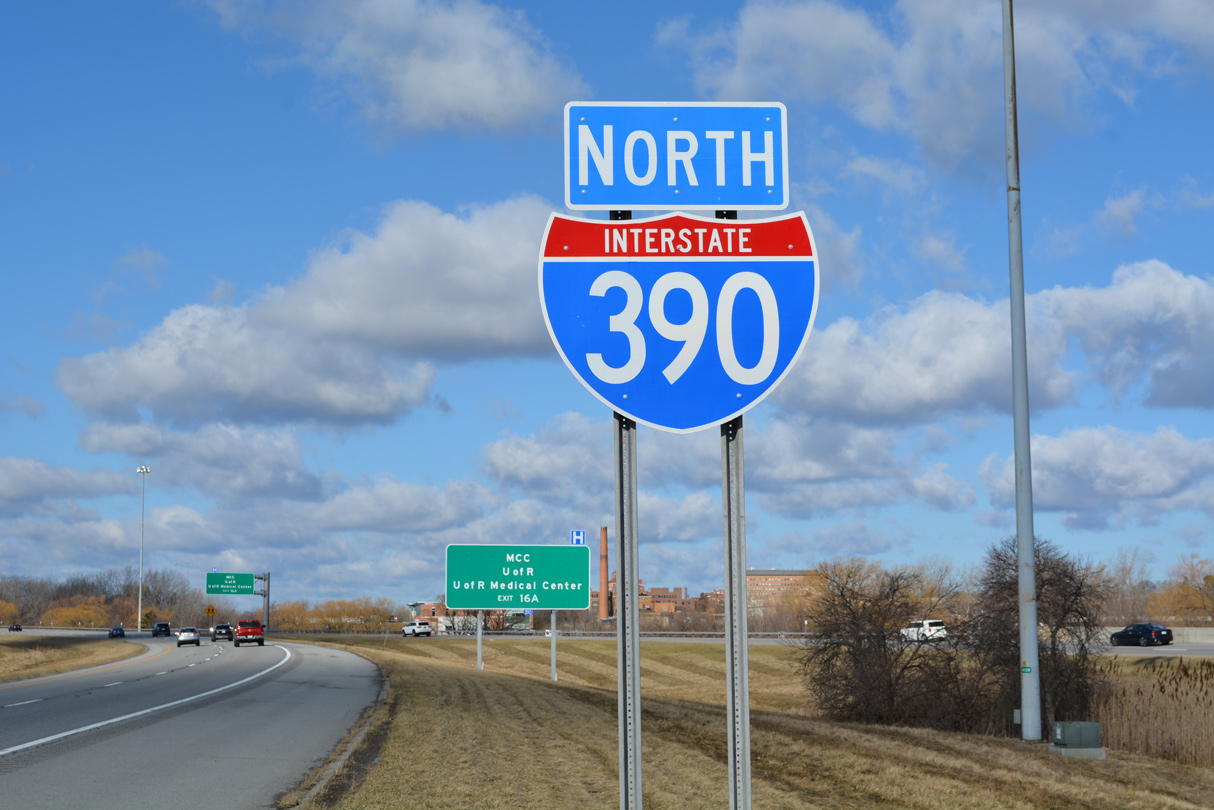
![]() North at
North at ![]()
![]()

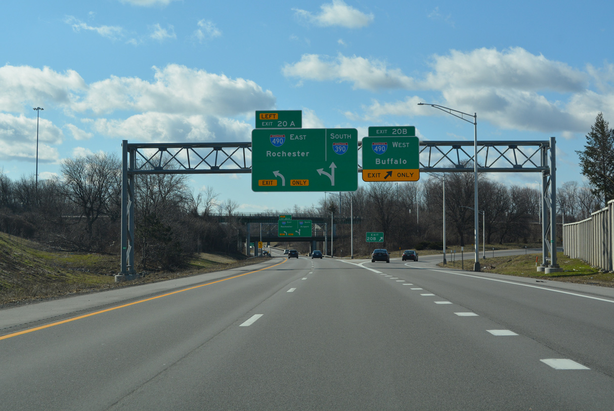
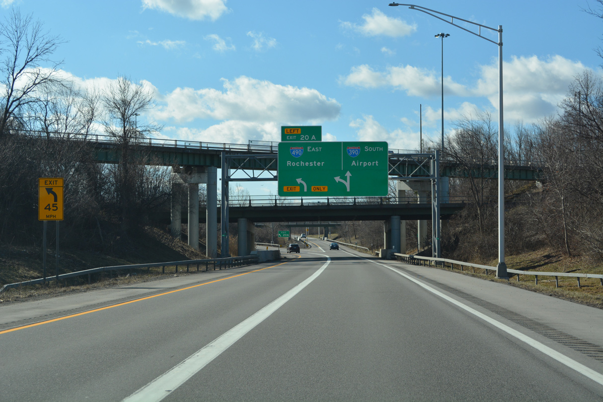
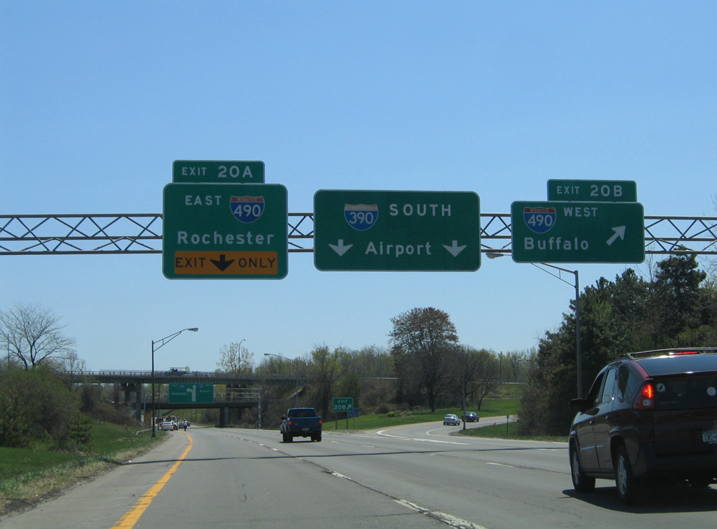
Heading northwest from ROC Airport, Interstate 390 proceeds one mile to Exit 20 A for I-490 east to Downtown Rochester and Exit 20 B for I-490 west toward Ogden and Spencerport. 03/26/23
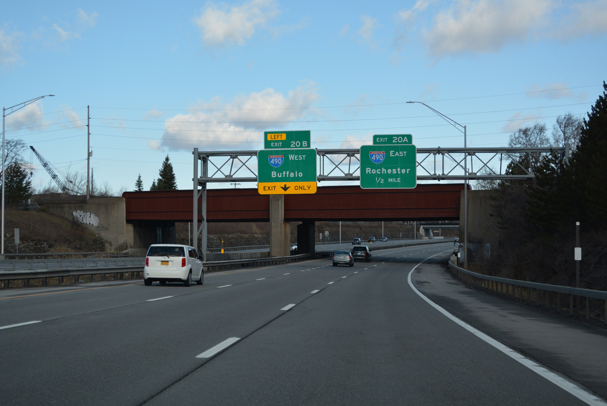
I-390 travels under a CSX Railroad and east of the Dolomite Quarry ahead of the exchange with Interstate 490 (Western Expressway). I-490 bee lines three miles east from I-390 through the Dutchtown neighborhood of Rochester to the Inner Loop Expressway encircling the central business district. 03/26/23
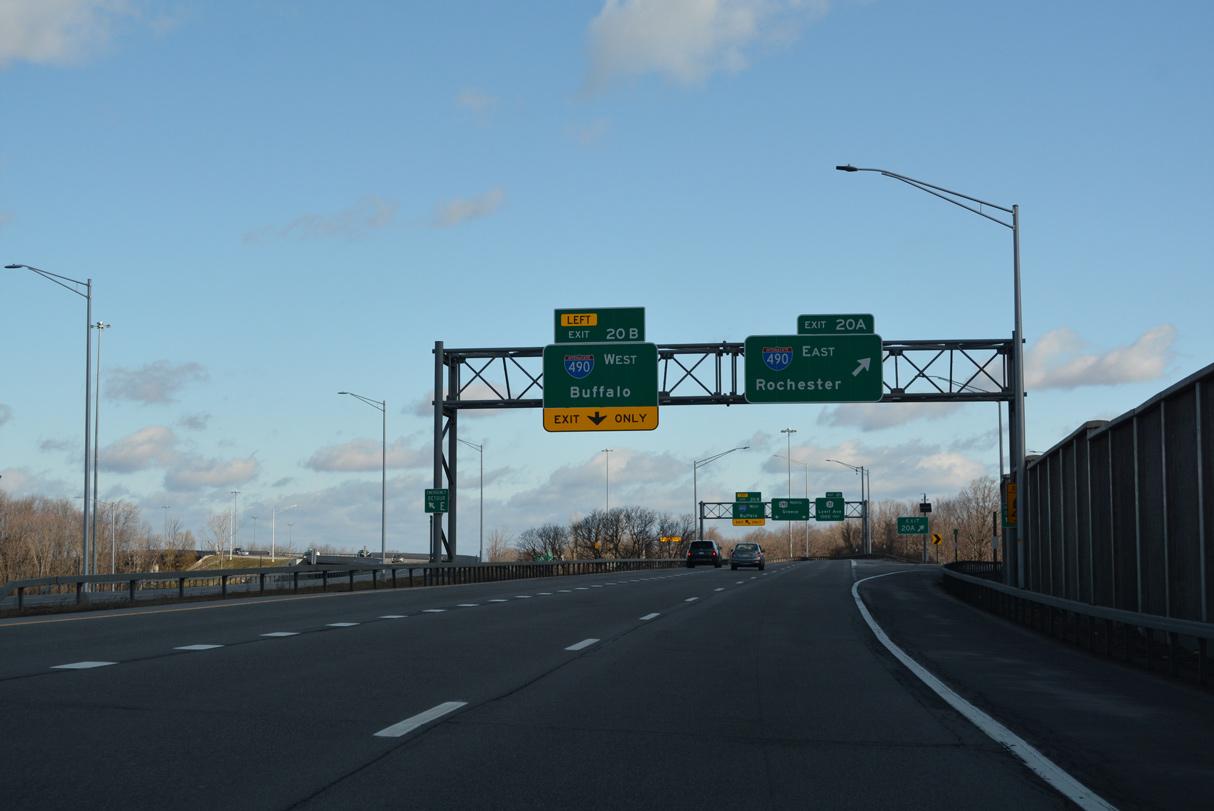
Left Exit 20 B departs from I-390 north next to Interstate 490 west for Brockport, Spencerport and the New York Thruway to Buffalo. 03/26/23

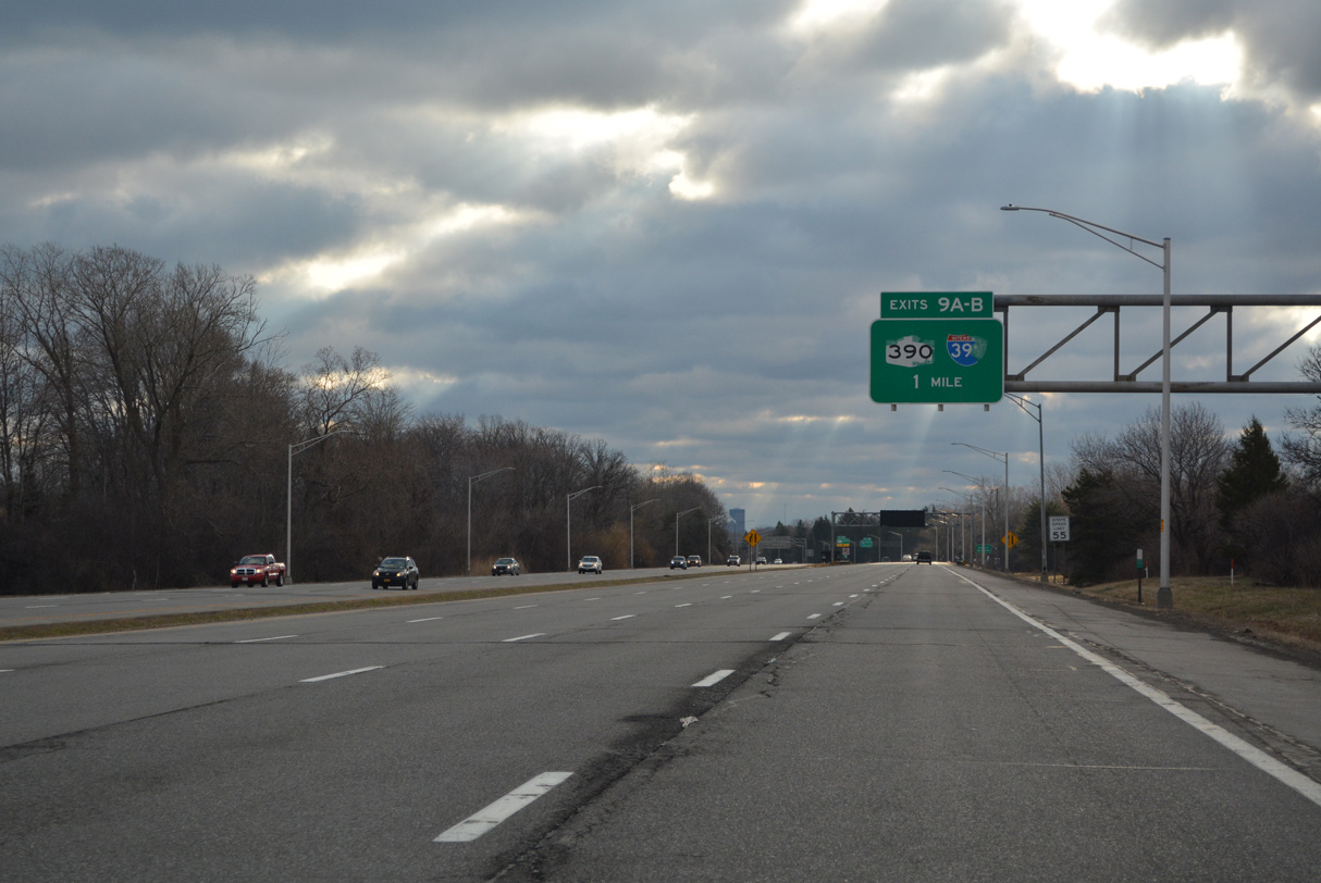
The Rochester Outer Loop extends 8.00 miles north along NY 390 to Lake Ontario State Parkway near Crescent Beach. 03/26/23
![]() East at
East at ![]()
![]()
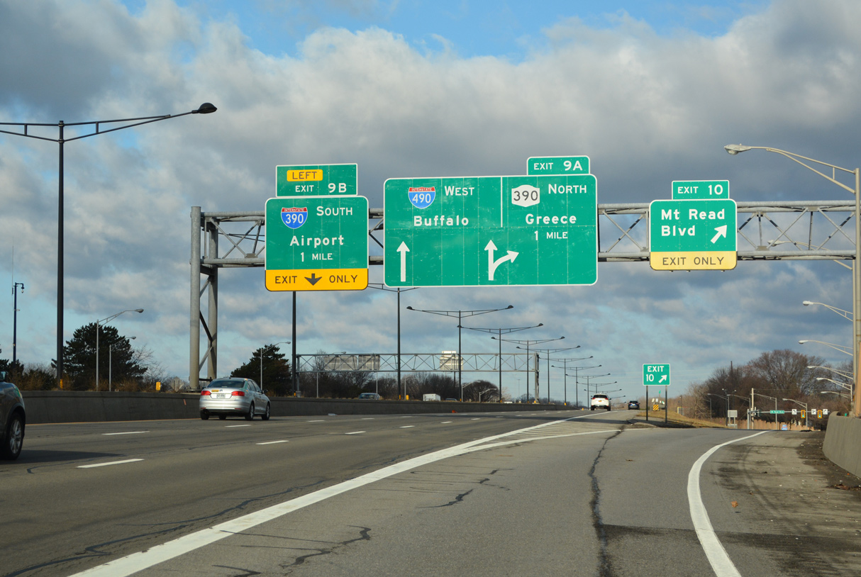
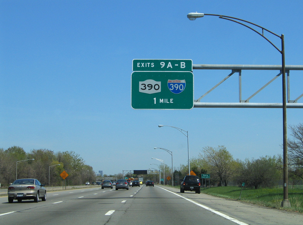
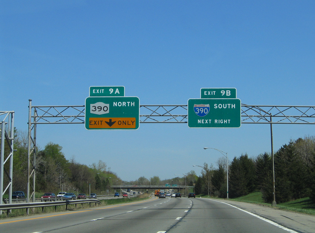
Advancing east from the three-wye interchange with NY 531 (Spencerport Expressway), Interstate 490 east expands to three lanes ahead of Exits 9 A/B with the Rochester Outer Loop. 03/26/23
The succeeding exit joins I-490 east with NY 390 to North Gates, Greece and Lake Ontario State Parkway. The western half of the Outer Loop is a full freeway, while the eastern half is not as a portion of the Sea Breeze Expressway was downgraded to an at-grade boulevard (Sea Breeze Drive). 03/26/23
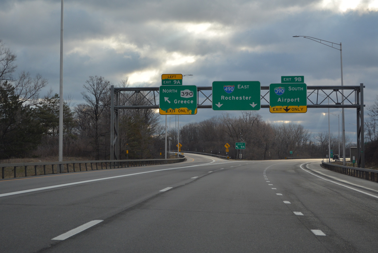
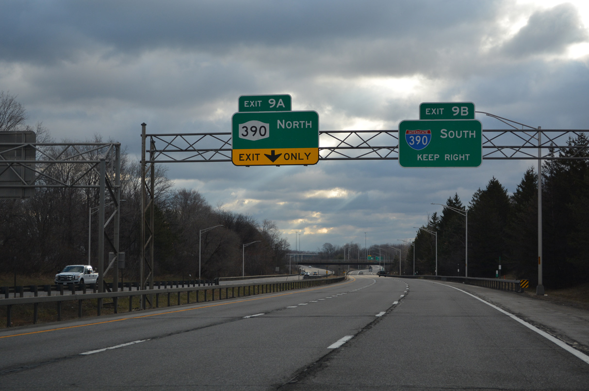
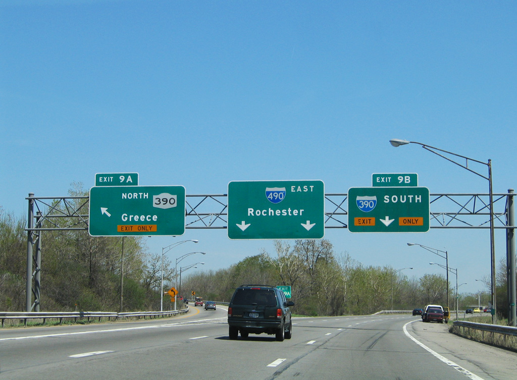
Left Exit 9 A departs Interstate 490 eastbound for NY 390 north. Exit 9 B follows for the Outer Loop southbound to Greater Rochester International Airport (ROC), west Brighton and the Genesee Expressway south to Henrietta. 03/26/23
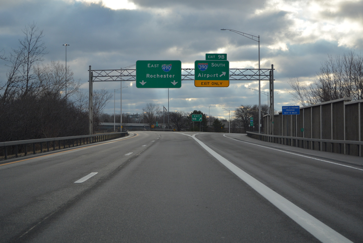
The roadways of Interstate 490 separate to accommodate left exit ramps with the Outer Loop. Airport is the initial control point for I-390 south at Exit 9 B. Corning is used at the exchange with Interstate 590. 03/26/23
![]() West at
West at ![]()
![]()
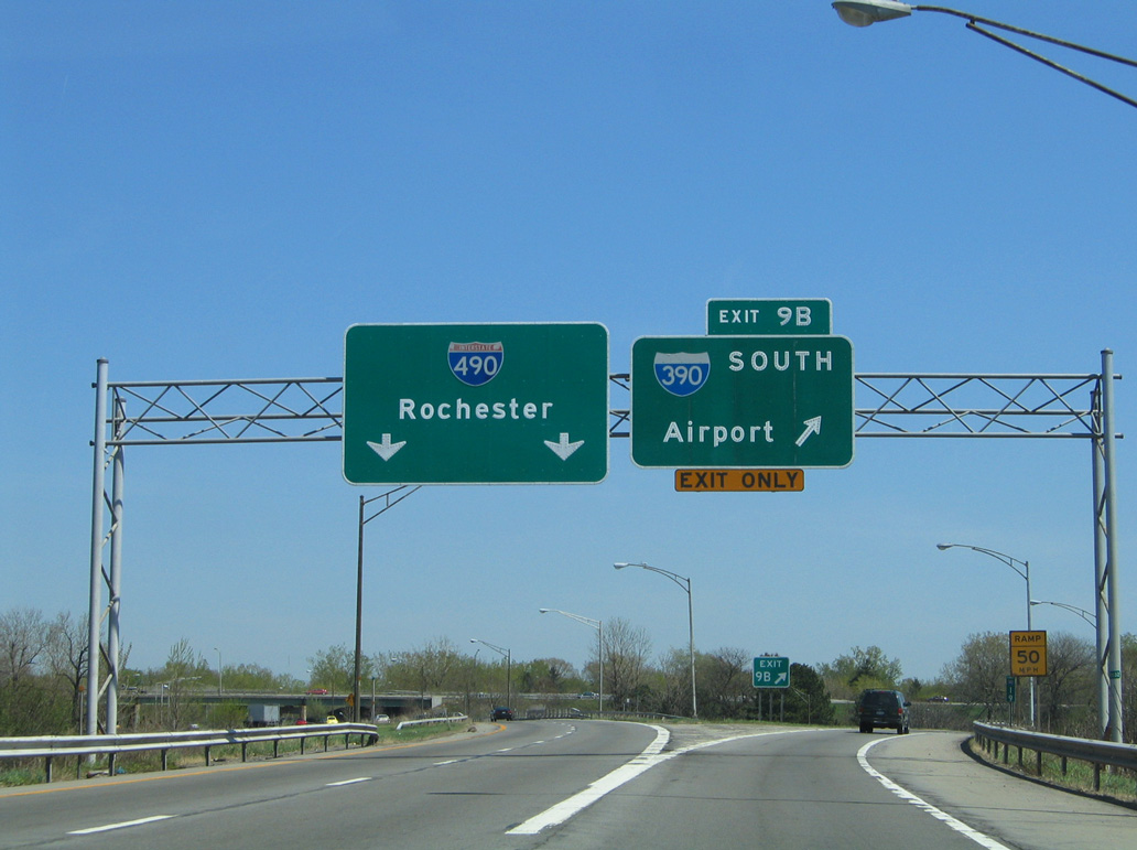
I-490 advances one mile west from the six-ramp parclo interchange (Exit 10) with Mt. Read Boulevard to the systems exchange (Exit 9) with I-390 south and NY 390 north. 03/26/23

Left Exit 9 B separates from I-490 a half mile west of the Rochester & Southern Railroad overpass for the Rochester Outer Loop south to Greater Rochester International Airport (ROC). 08/22/21

Sign changes made as part of the I-390/I-490 Interchange Improvement Project added APL’s for Exit 9 and Greece for New York Route 390 northbound. 08/22/21
![]() South at
South at ![]()
![]()
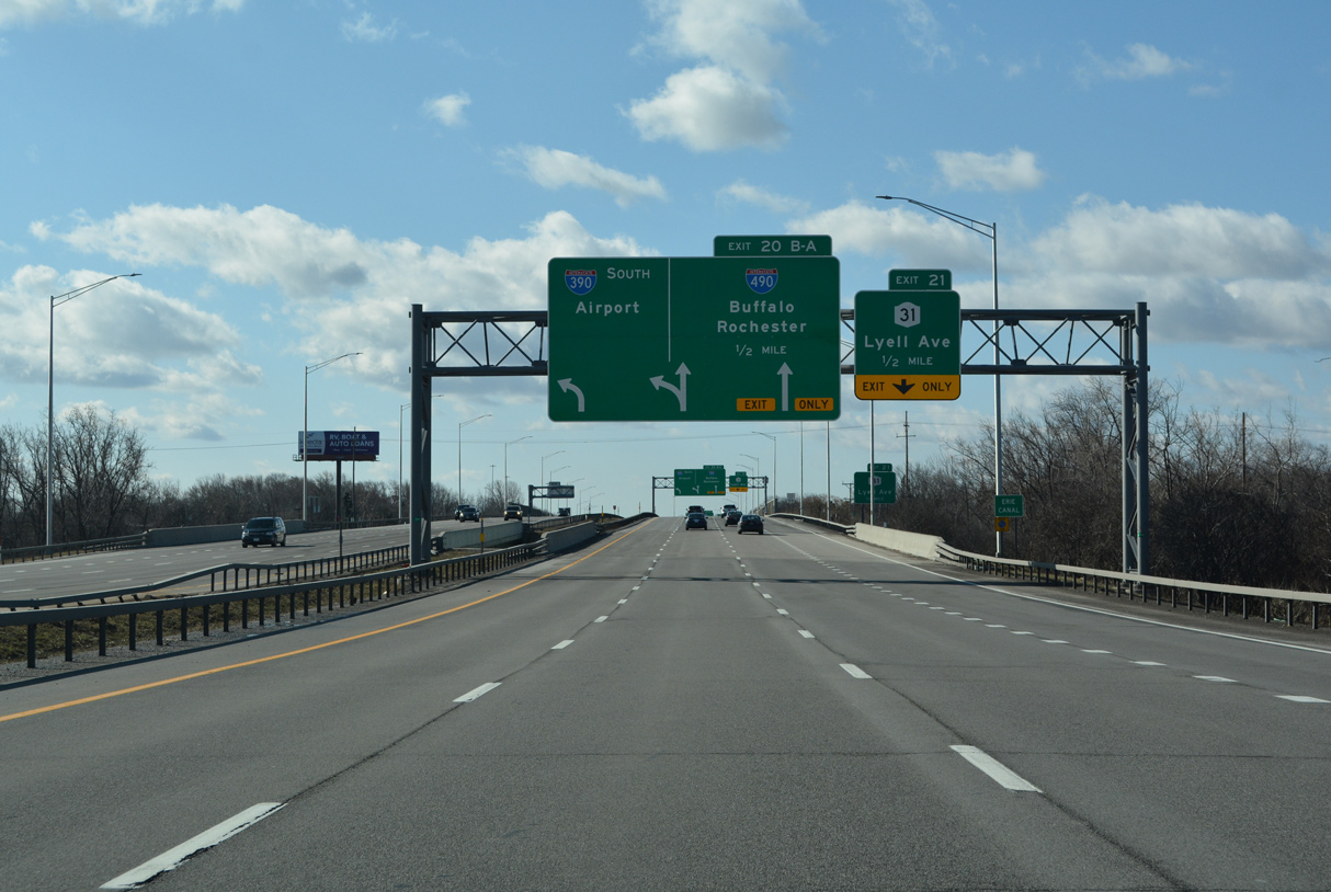
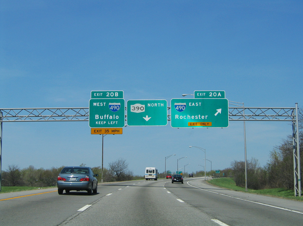
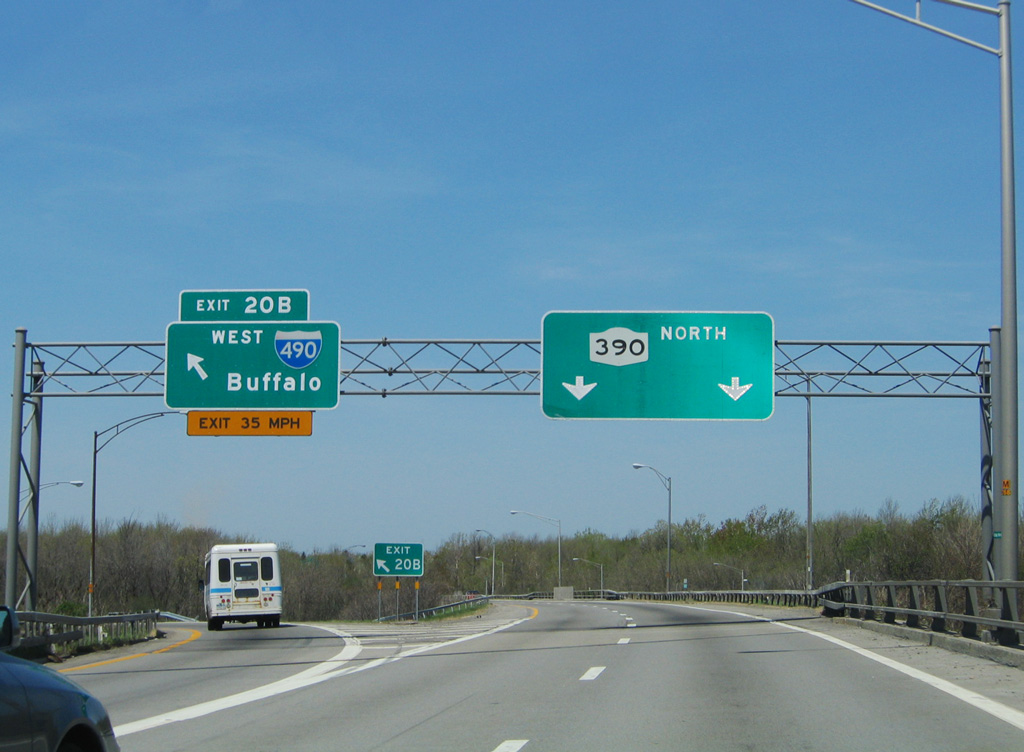
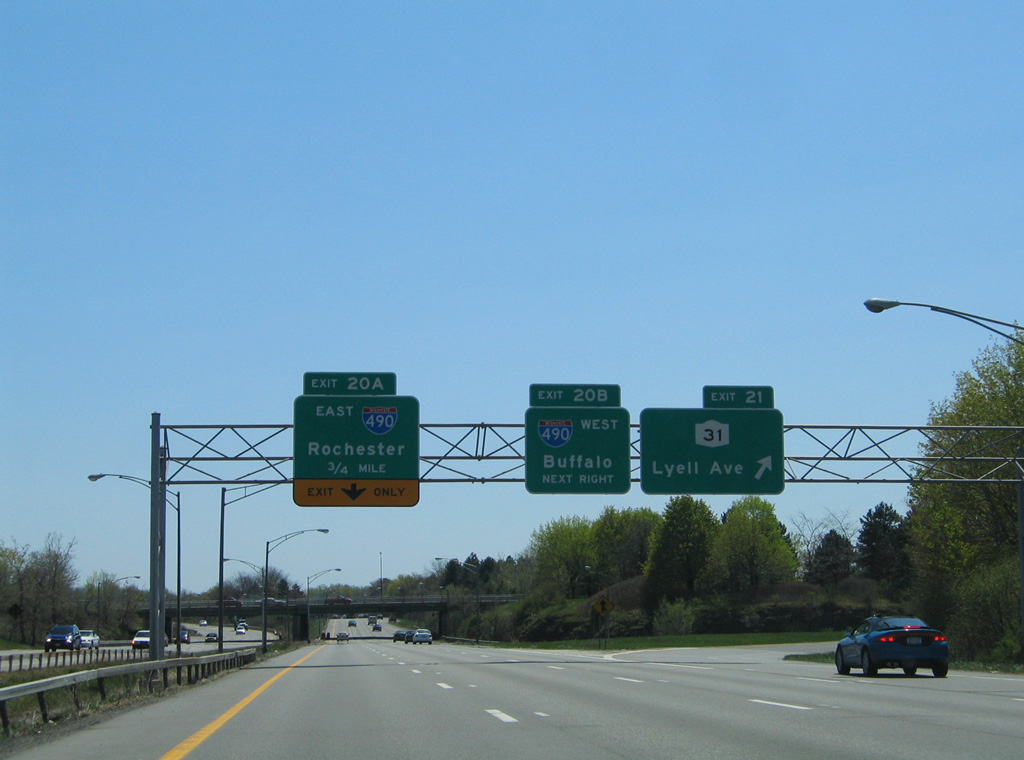
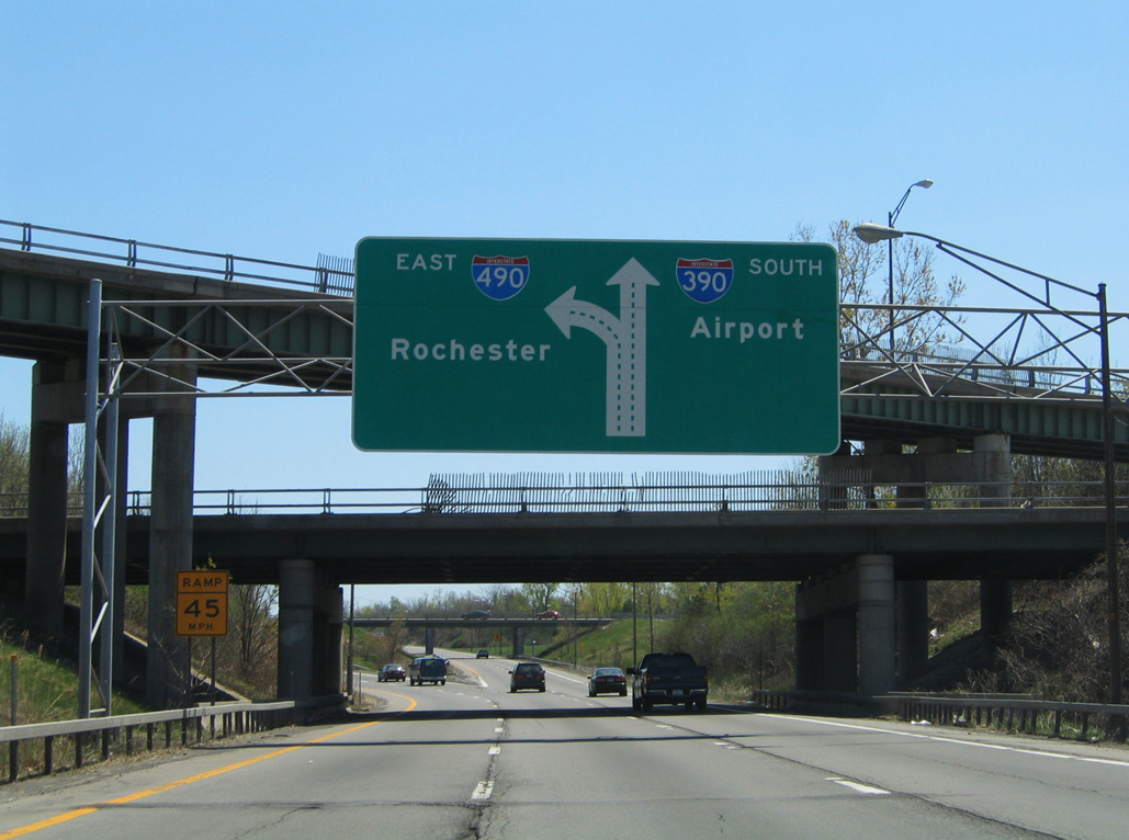
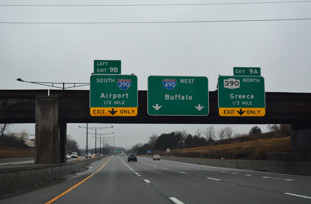
The Rochester Outer Loop continues the sequential exit number system for I-390 along NY 390. Exit 21 joins the freeway with NY 31 (Lyell Avenue) to the immediate north of Exit 20 for I-490. 03/25/23
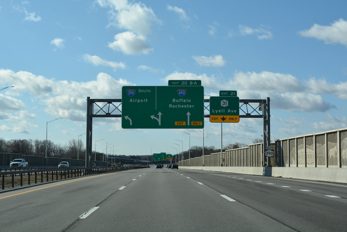
Paralleling I-490 a half mile to the north, NY 31 (Lyell Avenue) constitutes a commercial arterial east into the Lyell-Otis-Avery neighborhood of Rochester. 03/25/23

Exit 20 B leaves NY 390 south next for I-490 west through Gates to Chili, Riga and the NY Thruway to Buffalo. 03/25/23

NY 531 partitions with Interstate 490 nearby as a freeway extending west to Ogden and Spencerport. 03/25/23
A c/d roadway follows the former NY 390 southbound mainline to the ramps for Interstate 490 (Western Expressway). 03/25/23
Interstate 390 begins as NY 390 ends at Interstate 490. 03/25/23
North End Throwback
![]() North at
North at ![]()
![]()

Removed button copy signs at the CSX Railroad overpass a half mile south of I-490. 05/10/05
I-390 north at I-490 (Western Expressway) east. 05/10/05
I-390 north transitioned to NY 390 at Exit 20 B for I-490 west across Gates. 05/10/05
![]() South at
South at ![]()
![]()
NY 390 south at NY 31 (Lyell Avenue) prior to construction upgrading the adjacent exchange with Interstate 490. 05/10/05
The former southbound mainline of NY 390/I-390 was repurposed as a collector distributor roadway. 05/10/05
An arrow per lane sign (APL) replaced this diagrammatic sign for Exit 20 A to Interstate 490 east. 05/10/05
![]() East at
East at ![]()
![]()
This button copy guide sign on I-490 east for I-390/NY 390 was replaced by 2011. 05/10/15
Replaced button copy overheads for I-390 south and NY 390 north preceding the Howard Road (NY 940L) overpass in the town of Gates. 05/10/15
I-490 east at Exit 9 A for NY 390 north to Lake Ontario State Parkway. 05/10/15
Former button copy overheads at the southbound beginning of I-390 from I-490 (Western Expressway) eastbound. 05/10/15
![]() West at
West at ![]()
![]()

Construction during the Western Gateway Project slowed traffic along westbound I-490 leading to Interstate 390. Remaining button copy guide signs along the Western Expressway were replaced during the multi year project. 05/10/05

Sign changes made as part of the I-390/I-490 Interchange Improvement Project replaced all overheads for Exit 9 west from Mt. Read Boulevard with APL’s. 01/18/17
Overheads on the Rochester & Southern Railroad overpass were replaced with a sign bridge. 01/18/17

05/10/05

01/18/17
With the exception of a left exit tab for Interstate 390 south, overheads on I-490 west at the Outer Loop were carbon copied by 2012.
South End  – Kanona, New York
![]() South at
South at ![]()
![]()

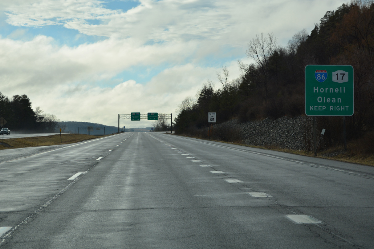
I-390 concludes at Interstate 86 (Southern Tier Expressway) just southeast of the village of Avoca in rural Steuben County. Dropping both NY 15 and NY 17, all guide signs for this rural exchange were replaced by 2012. 01/18/17

An unnumbered ramp links I-390 south with I-86 west to Hornell, Olean and Erie, Pennsylvania. Jamestown, a city of nearly 30,000 in Chautauqua County, lies 116 miles to the west. 01/18/17

Interstate 390 south defaults onto I-86 (Southern Tier Expressway) east ahead of Bath. The rural freeway waves alongside the Cohocton River southeast 24 miles to Interstate 99 at Painted Post. 01/18/17

A pair of end shields stand along Interstate 390 south by the overpassing carrying I-86 (Southern Tier Expressway) westbound. NY 15 formerly overlapped with NY 17 east to Painted Post, where U.S. 15 begins south to Presho and Mansfield, Pennsylvania. 01/18/17
![]()
![]() West at
West at ![]()
Spanning NY 53 at Kanona, I-86/NY 17 advances 0.75 miles west to split with Interstate 390. 03/25/23

The entrance ramp from NY 53 forms an auxiliary lane west from Fivemile Creek a third of a mile to the modified trumpet interchange with Interstate 390 north. 03/25/23
The rural route of I-86 and the Southern Tier Expressway (NY 17) serves the small cities of Olean and Jamestown along the 153 mile long course west to Interstate 90 in Pennsylvania. Olean, 66.3 miles away, lies at the west end of NY 417, which formerly carried NY 17 from Erwins. 03/25/23

Two lanes default onto I-390 north for Rochester and Buffalo via the New York State Thruway or U.S. 20 at an unnumbered exit from I-86/NY 17 westbound. Dansville, a village of over 4,000, is 22 miles to the northwest. NY 15 formerly overlapped with I-390 north to Exit 3 outside Wayland. 03/25/23
![]()
![]() East at
East at ![]()

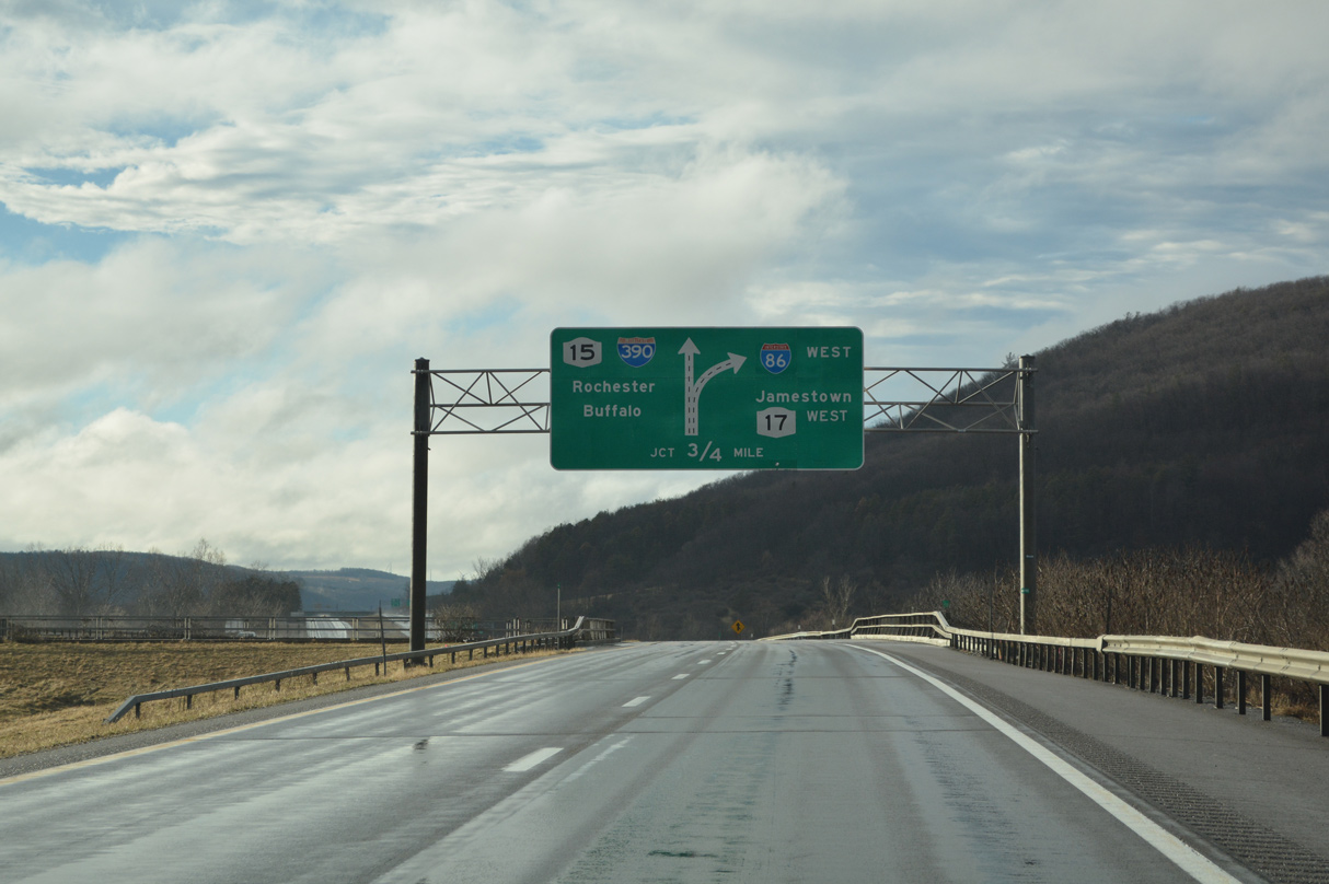
A 6.7 mile exit less stretch takes motorists along I-86 (Southern Tier Expressway) east from Howard to the south end of Interstate 390 in the town of Avoca. 08/23/21

The modified trumpet interchange at Exit 36 utilizes a 180 degree loop ramp from I-86/NY 17 east onto Interstate 390 north toward Rochester. 08/23/21

Interstate 86 narrows to a single through lane as Exit 36 departs for I-390/NY 15 north to Dansville, Geneseo and Avon. 08/23/21
Sources:
- Dansville History – Dansville Public Library.
- Interstate 390, New York Routes web site.
- The Genesee Expressway
http://home.rochester.rr.com/ kreativ/brian/genesee.htm, Brian Campbell. - “Major Milestone in the I-390/I-490/Route 31 Interchange Improvement Project Will Ease Travel and Enhance Safety.” New York Governor’s Press Office, September 16, 2021.
- “NYSDOT’s Interstate 390/Interstate 490/Lyell Avenue Interchange Reconfiguration Project Recognized by the American Public Works Association.” New York State Department of Transportation (NYSDOT), press release. March 25, 2022.
Page updated April 5, 2023.