Interstate 376 Pennsylvania
Overview
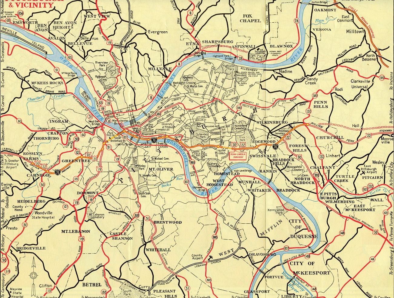
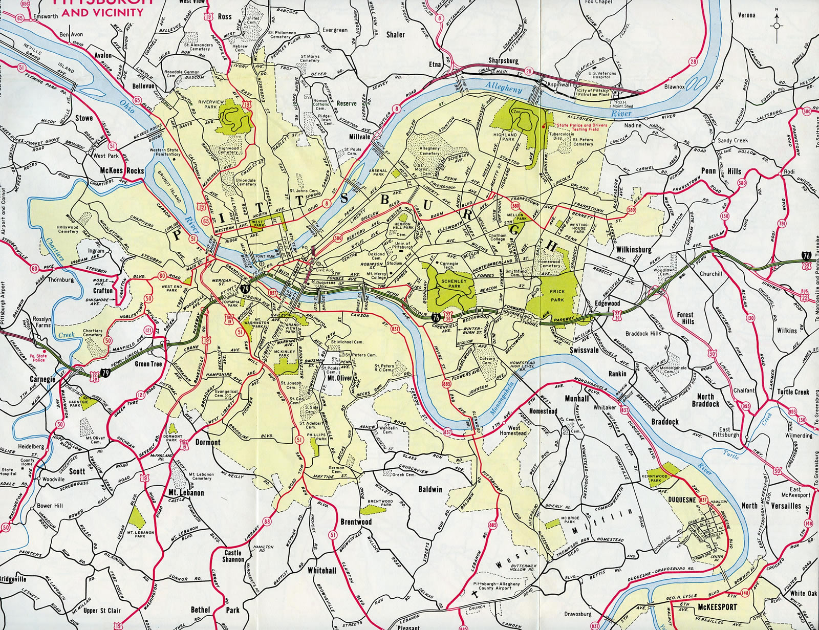
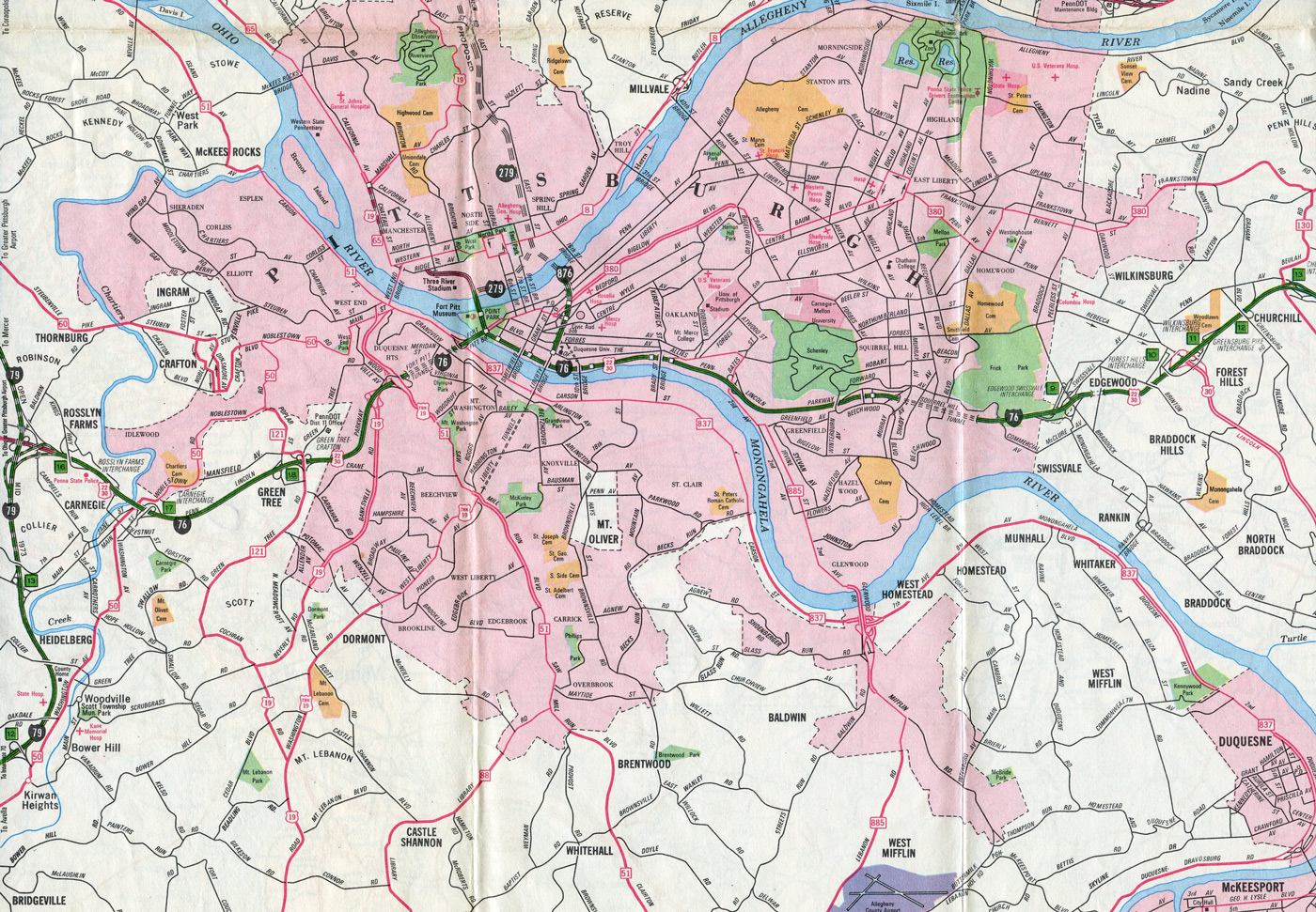
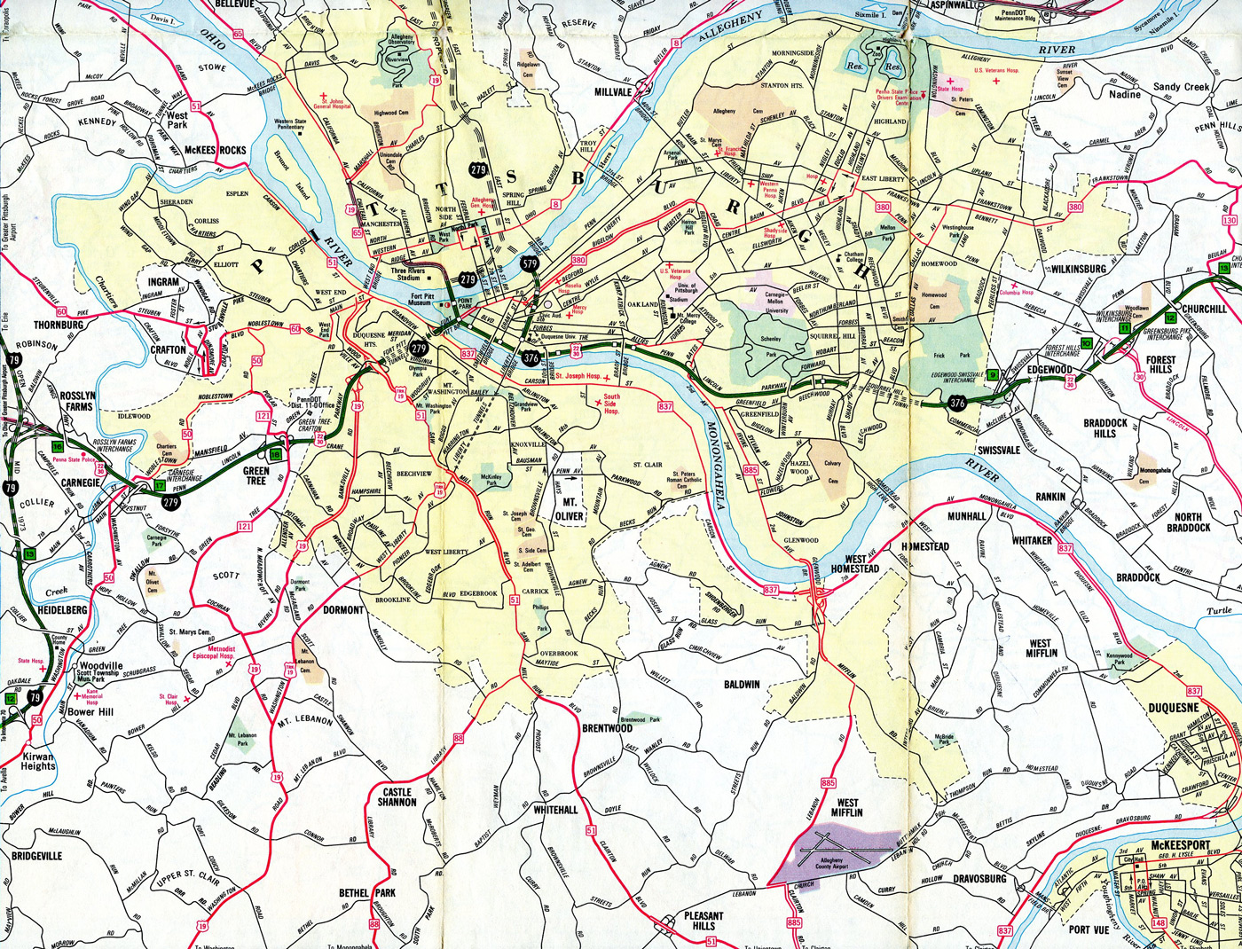
Interstate 376 originally ran along just the Penn-Lincoln Parkway East through Pittsburgh to the eastern suburbs of Edgewood, Forest Hills and Churchill. The freeway follows the Monongahela River initially, then turns away from the river via the Squirrel Hill Tunnel. Often referred to as the Parkway East, the parkway predated the Interstate system as U.S. 22/30 to connect Pittsburgh with the Pennsylvania Turnpike mainline at Monroeville.
In June 2009, the route was extended over Interstate 279 onto Parkway West to I-79 near Carnegie in preparation for its northward extension to I-80 near Sharon. With that action, Interstate 376 carries U.S. 22 (William Penn Highway) for its entire length along the Penn-Lincoln Parkway, and U.S. 30 (Lincoln Highway) from Wilkinsburg to Moon Run. Both U.S. routes are well-signed (except that the continuation of U.S. 22/30 west onto the Fort Pitt Bridge is unmarked).
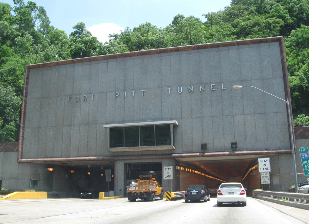
Eastbound I-376/U.S. 22-30 (Penn-Lincoln Parkway West) enter the Fort Pitt Tunnel. Measuring 3,614 feet in length,1 the tunnel passes under Mount Washington and emerges on the Fort Pitt Bridge. 06/12/10
Further extension of I-376 replaced the PA 60 (Airport Expressway) from Robinson Township, around Pittsburgh International Airport (PIT), to Beaver Falls. Additional lengthening of the route took place in November 2009, with I-376 overlaying the tolled Beaver Valley Expressway, which is maintained by the Pennsylvania Turnpike Commission (PTC), and the New Castle bypass to end at Interstate 80, five miles east of the Ohio state line.
The expressway / arterial route of PA 60 Business to Pittsburgh International Airport vicinity was redesignated Business Loop I-376 with the westward extension of the I-376 mainline. PA 60 otherwise was truncated north of I-376 and U.S. 22/30, leaving just a 9.4 mile route east to U.S. 19 in Pittsburgh. The 5.5 mile spur of PA 60 north from I-80 into Sharon was redesignated as PA 760.
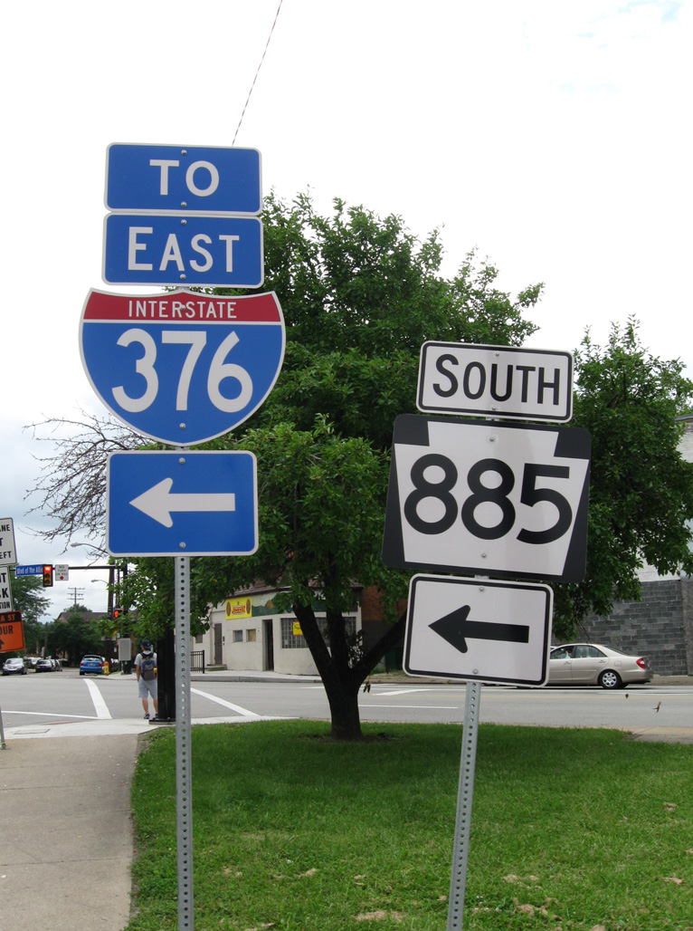
Interstate 376 connects with PA Turnpike 576 (Findlay Connector) near Penn Hills and Monroeville. PA 576 is the Southern Beltway, a planned toll road bypassing much of the Pittsburgh area to the south between I-376 near PIT Airport and I-376 at Monroeville. The segment leading southwest from Interstate 376 to U.S. 22-30 (William Penn Highway) opened to traffic on October 11, 2006.
High Priority Corridor
Interstate 376 in its entirety is part of High Priority Corridor 79: Interstate 376; its designation was written into law.
Route Information
East End – Monroeville, PA
West End – Sharon, PA
Mileage – 85.60
Cities – Pittsburgh, Monroeville, Wilkinsburg
- Junctions –


Source: December 31, 2021 Interstate Route Log and Finders List
I-376 Annual Average Daily Traffic (AADT)
Source: 2017 PennDOT Traffic Volume Maps

I-376 emerges from the Fort Pitt Tunnel through Mount Washington directly onto the Fort Pitt Bridge. The yellow tied arch bridge spans the Monongahela River east to Interstate 279 at the Point and Downtown Pittsburgh. The Monongahela River combines with the Allegheny River nearby to form the Ohio River. 11/01/04
 History
Construction of Interstate 376 began in 1946 on the Penn-Lincoln East Parkway, followed by work commencing on the Squirrel Hill Tunnel in 1948. Including the tunnel, the first section opened to traffic in June 1953. Work continued until 1959 on the parkway. Additional work, linking the parkway with the Pennsylvania Turnpike, was underway between 1961 and October 1962.2
The Parkway West was constructed in the 1950s as the new alignment for U.S. 22/30. Following three years of construction, the Fort Pitt Bridge opened on June 19, 19591 as a local link from Parkway East to Carson Street over the west banks of the Monogahela River.3 Painted Aztec Gold, the tied arch bridge provides 47.1 feet of vertical clearance with a main span of 640 feet in length.4 Concurrent construction was underway on the 3,614 foot long Fort Pitt Tunnel, which bored through Mount Washington. It opened on September 1, 1960.1,4
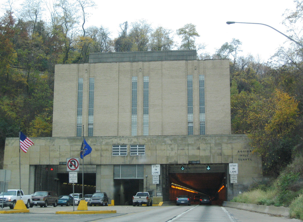
Opened to traffic on June 5, 1953, the Squirrel Hill Tunnel carries Interstate 376/U.S. 22-30 under Squirrel Hill in Pittsburgh. The 4,225 foot long twin-tube tunnel bypasses the neighborhoods east of Beechwood Avenue and south of Forward Avenue.5 Each tube accommodates two lanes of travel. The tunnel is an integral link between Downtown Pittsburgh and Monroeville, where Interstate 376 meets the Pennsylvania Turnpike (I-76). 11/01/04
Numbering Changes
Penn Lincoln Parkway West and East was initially included in the Interstate 70 mainline as it looped north through Pittsburgh from Washington to the Pennsylvania Turnpike at New Stanton. The current route of I-70 between Washington and New Stanton to the south was designated at that time as Interstate 70S while the PA Turnpike was labeled I-80S.
Several numbering changes were implemented by 1963, with I-70 shifted southward to its present alignment, I-80S dropped from Monroeville east to Philadelphia and replaced with new I-76, and Parkway West reassigned as the southern third of the Interstate 79 loop through Pittsburgh.
Changes approved by the American Association of State Highway Officials (AASHO) on June 30, 1970 reassigned Parkway West as an extension of Interstate 76 in place of I-279 between the Fort Pitt Bridge and the new alignment of I-79 near Carnegie. I-279 was redesignated along just the Fort Duquesne Bridge and unconstructed Parkway North.
A subsequent application sent to AASHTO in 1970 resulted in further changes for the Pittsburgh area. Approved on December 3, 1971 were:
- Renumbering I-80S northwest from Monroeville as an extension of I-76
- Reassigning I-76 between I-279 at the Fort Pitt Bridge east end and I-80S at Monroeville as new Interstate 376
- Extend Interstate 279 west over I-76 along the Fort Pitt Bridge and Parkway West to I-79
Also included in the 1971 application was the renumbering of Interstate 876 to 579, reflecting the change of Crosstown Boulevard from a complete loop into a spur with no direct connection to I-376.
Interstate 376 Extension
Discussions on extending Interstate 376 dated back to at least 1994, when officials toured the route.6 On July 10, 2003, a bill was introduced to the U.S. House of Representatives, HR 2695 IH that would legislatively convert Pennsylvania 60 into Interstate 376. The text of the bill, reads:
To designate Pennsylvania State Route 60 and United States Routes 22 and 30 as part of the Dwight D. Eisenhower National System of Interstate and Defense Highways, and for other purposes.
SECTION 1. DESIGNATION TO INTERSTATE SYSTEM. Pennsylvania State Route 60 from Interstate Route 80 south to United States Routes 22 and 30 Interchange at Steubenville Pike, Pennsylvania, and United States Routes 22 and 30 from Pennsylvania State Route 60 Interchange to Interstate Route 79 are designated as part of the Dwight D. Eisenhower National System of Interstate and Defense Highways as Interstate Route 376. Any segment of such routes shall become a part of the Interstate System at such time as the Secretary of Transportation determines that the segment meets the Interstate System design standards approved by the Secretary under section 109(b) of title 23, United States Code. On the date of the Secretary’s determination, such routes shall be designated as Interstate Route 376 and the State of Pennsylvania shall erect signs identifying such routes as segments of Interstate Route 376.
SEC. 2. REDESIGNATION OF INTERSTATE ROUTE 279 AS 376/279. Interstate Route 279 from Interstate Route 79 east to Interstate Route 376 at Point State Park, Pennsylvania, is redesignated as Interstate Route 376/279. The State of Pennsylvania shall erect signs identifying such segment of Interstate Route 279 as Interstate Route 376/279.
As this bill as written, an overlap would be created between I-279 and I-376 along the Parkway West and that almost all of Pennsylvania Route 60 would become part of Interstate 376, along with portions of U.S. 22-30 and U.S. 422 near New Castle. By adding this mileage, Interstate 376 would nearly triple in length, and intersect its parent (I-76 / Pennsylvania Turnpike) twice.
As of May 2004, it appeared that while the entire proposed corridor for I-376 could use upgrades, the Federal Highway Administration (FHWA) might not require PennDOT to spend the millions of dollars necessary to bring the road to modern engineering standards. FHWA engineers advocated for at least minimal improvements to make the corridor safer. As a result, needed construction would be much less expensive than originally considered, and Interstate 376 could have been fully signed by as soon as 2007.7
In May 2005, plans to extend Interstate 376 northwest grew one step closer to fruition. The FHWA provided PennDOT with a list of prioritized changes and modifications that were required to be made along the entire 90-mile route from Monroeville west to Pittsburgh International Airport (PIT) and north to Sharon. The areas of improvements were grouped into four categories, the first three were mandatory and the last could be waived via justifications from the state:6
- Category 1 — improvement of several sub-standard features of the 90-mile corridor, including guide-rail and median barriers, sign and lighting placements, and right-of-way fences. Cost: $21.8 million.
- Category 2 — improvement of deficiencies that required final designs to be completed and have funding in place for construction. This included the replacement of several older, button copy signs in Beaver County and Lawrence County. Cost: $12.4 million.
- Category 3 — these projects included an improvement to the cloverleaf interchange along the Parkway West at Routes 22, 30 and 60 in Robinson. Cost: $57.2 million.
- Category 4 — consisted of design deficiencies that would cost an estimated $83.1 million to correct but which the FHWA would not require, provided PennDOT makes a case for the exceptions.
Some officials wanted to see the Interstate 376 designation approved by the FHWA immediately, with a subsequent commitment to address those issues over time. The rational behind an extended I-376, was that travelers to the region would benefit from the reduced confusion that a single route number over the 90-mile corridor would provide. Additionally, supporters touted the potential economic development along a simplified route in place of the previous six routes between Sharon and Monroeville.8 A third benefit cited was that a single route number (I-376) would ease directions to Pittsburgh International Airport (PIT).
On August 10, 2005, the extension of I-376 from Downtown Pittsburgh to I-76 via I-279, U.S. 22-30, and PA 60 was made an official Future Interstate Corridor as part of the Safe, Accountable, Flexible, Efficient Transportation Equity Act: A Legacy for Users (SAFETEA-LU). The section of PA 60, from Interstate 76 (Pennsylvania Turnpike) north to I-80, would be added to the Interstate System once the highway met Interstate standards. An excerpt of language from SAFETEA-LU Section 1308(c), “Interstate Routes”:
(B) INTERSTATE ROUTE 376.-
- (i) DESIGNATION OF INTERSTATE ROUTE 376.-
- (I) IN GENERAL.-The routes referred to in subsection (c)(79), except the portion of Pennsylvania Turnpike Route 60 and United States Route 422 between Pennsylvania Turnpike Interchange 10 and Interstate Route 80, shall be designated as Interstate Route 376.
- (II) SIGNS.-The State of Pennsylvania shall have jurisdiction over the highways described in subclause (I) (except Pennsylvania Turnpike Route 60) and erect signs in accordance with Interstate signing criteria that identify the routes described in subclause (I) as Interstate Route 376.
- (III) ASSISTANCE FROM SECRETARY.-The Secretary shall assist the State of Pennsylvania in carrying out, not later than December 31, 2008, an activity under subclause (II) relating to Interstate Route 376 and in complying with sections 109 and 139 of title 23, United States Code.
- (ii) OTHER SEGMENTS.-The segment of the route referred to in subsection (c)(79) located between the Pennsylvania Turnpike, Interchange 10, and Interstate Route 80 may be signed as Interstate Route 376 under clause (i)(II) if that segment meets the criteria under sections 109 and 139 of title 23, United States Code.’
PennDOT and the FHWA negotiated terms by March 2006 to bring the extended route of I-376 to Interstate standards. Upgrades for the new designation would cost approximately $45 million.9 Improvements were targeted for ten interchanges, at specific median and guardrails, and for numerous sign changes. Plans called for Interstate 279 to end at the Fort Pitt interchange Downtown, and I-376 (and U.S. 22-30) to be signed solely along the route of I-279 along Penn-Lincoln Parkway West. Signs advertising Future Interstate 376 were planned for installation by May 2006, with the resigning of Parkway West to I-376, contingent upon funding availability, envisioned for 2008.
To that end, on May 6, 2006, The American Association of State Highway and Transportation Officials (AASHTO) Special Committee on Route Numbering approved the extension of Interstate 376 from Downtown Pittsburgh west to I-79 via Penn Lincoln Parkway West. This action eliminated I-279 from I-79 to the old west end of I-376, though the route remained signed along Parkway West through Summer 2009.10
The remainder of Interstate 376 north along PA 60 on the Airport and Beaver Valley Expressways was finally designated on June 10, 2009 per announcement from the Pennsylvania Department of Transportation, District 11-0. The extension coincided with $40 million in upgrades along the corridor.10 PennDOT received exemptions from bringing all of the route to modern highway standards, saving an estimated $150 million in costs. This included keeping several overpasses not meeting the 16 foot, 6 inch verticle clearance requirement. Sign installation and exit renumbering took place throughout Summer 2009. Mileposts and shields along the corridor in Beaver County were concealed pending federal approval of the full redesignation.11
A formal ceremony held near the Hopewell interchange in Beaver County on November 6, 2009 finalized the northernmost portion of Interstate 376. Signs for I-376 were unveiled in Beaver County as a $13.7 million project to reconfigure the cloverleaf interchange joining U.S. 22/30 with PA 60 near Robinson Town Centre continued.12,13 Sign changes continued throughout 2010, with crews replacing signs along the Beaver Valley Expressway (former PA Turnpike 60) by August 1.14 The Route 22/30/60 project ran through November 2010, with loop ramps removed from PA 60 west to I-376. The completed interchange work at U.S. 22/30 and PA 60 earned the American Council of Engineering Companies of Pennsylvania (ACEC/PA), 2012 Diamond Award Certificate for Engineering Excellence in Transportation.13
 Photo Guides
East End 
 – Monroeville, Pennsylvania
![]()
![]() East at
East at ![]()
![]()
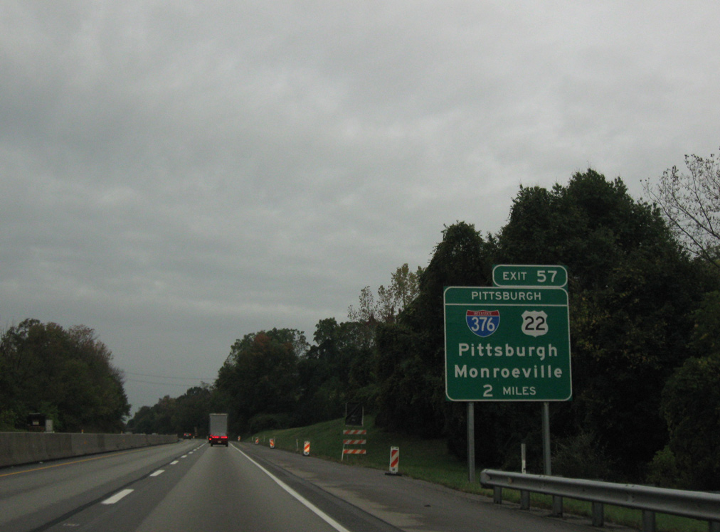
Two miles north of the trumpet interchange (Exit 57) and access road joining I-76 with Interstate 376 (Penn Lincoln Parkway East) west and U.S. 22 (William Penn Highway) on the Pennsylvania Turnpike eastbound. 09/30/10

Interstate 76 enters the borough of Monroeville by an industrial park on the one mile approach to Exit 57 with I-376 west and U.S. 22. 09/30/10
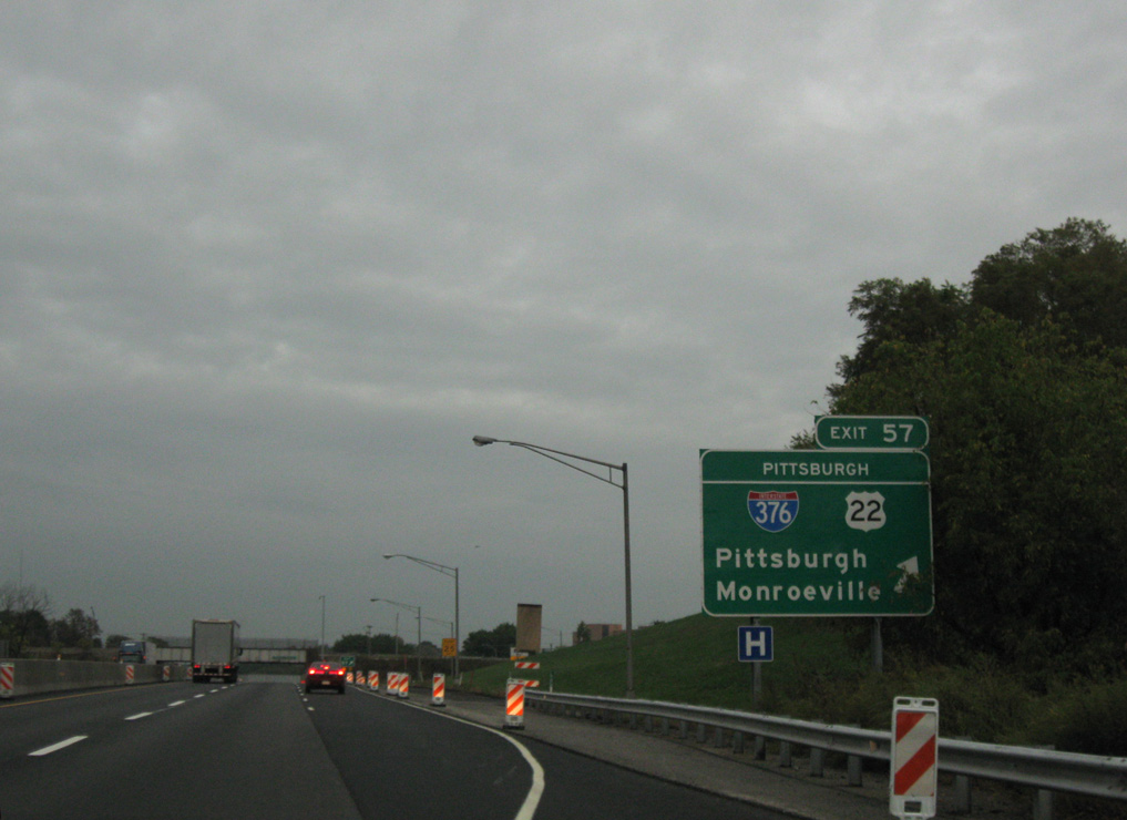
Exit 57 leaves I-76 (Pennsylvania Turnpike) east after the toll road crosses over U.S. 22 (William Penn Highway). U.S. 22 east travels at grade to Murraysville. The US route west combines with I-376 along Penn Lincoln Parkway West through Murraysville and Pittsburgh. 09/30/10

Ramps from both directions of the Pennsylvania Turnpike to I-376/U.S. 22 expand to two lanes, expanding the access road to four lanes ahead of the Pittsburgh Interchange toll plaza. 09/30/10
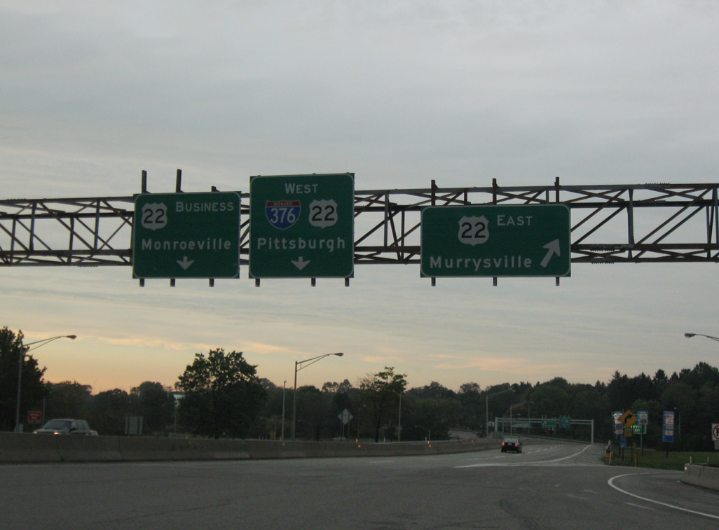
Vacating the toll plaza, traffic enters a trumpet interchange with U.S. 22 east and U.S. 22 Business west. 09/30/10
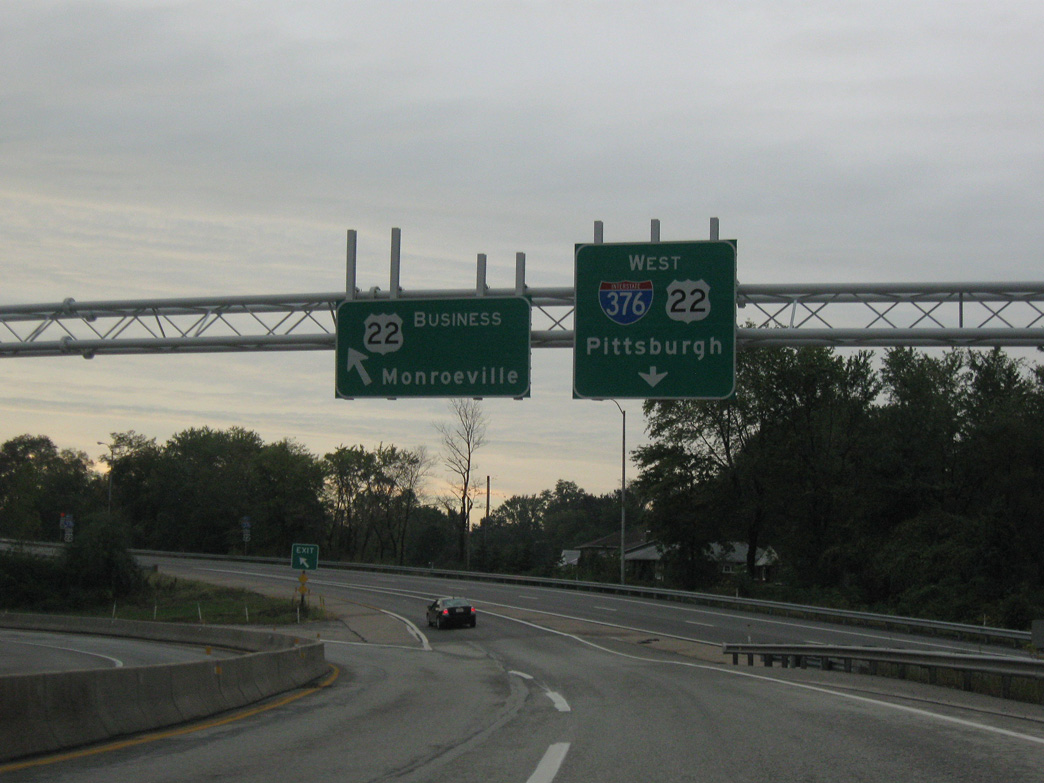
U.S. 22 shifts from William Penn Highway onto Penn Lincoln Parkway East via a wye interchange located within the exchange linking I-376 with U.S. 22 Business. A slip ramp forms the beginning of I-376 as traffic combines with U.S. 22 west. 09/30/10
East End Throwback
![]()
![]() Penn Lincoln Parkway East at
Penn Lincoln Parkway East at ![]()
![]()
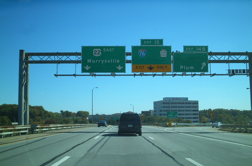
I-376/U.S. 22 part ways just beyond Exit 84 B for Haymaker Road to the borough of Plum. Two lanes depart for William Penn Highway while a slip ramp (Exit 85) joins an adjacent on-ramp to the Pennsylvania Turnpike access road. Signs pictured here for U.S. 22 and Plum remained in use as of 2015. The overhead for Exit 15 was replaced to show Exit 85 for Ohio and Harrisburg. 10/14/01
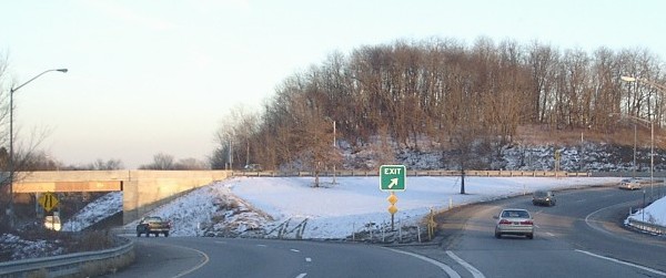
Traffic splits with U.S. 22 joining William Penn Highway to Murrysville and a single lane ramp combining with the U.S. 22 Business eastbound entrance ramp to I-76 (Pennsylvania Turnpike). There was an end shield for I-376 posted here previously. Photo by Jeff Kitsko (03/01).
Long since replaced, these button copy signs were posted just beyond the Pittsburgh Interchange toll plaza along the PA Turnpike access road. 10/14/01
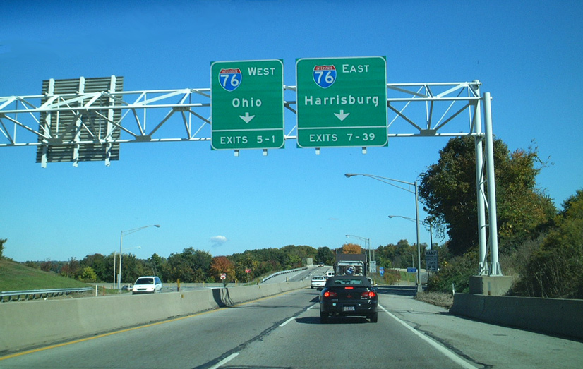
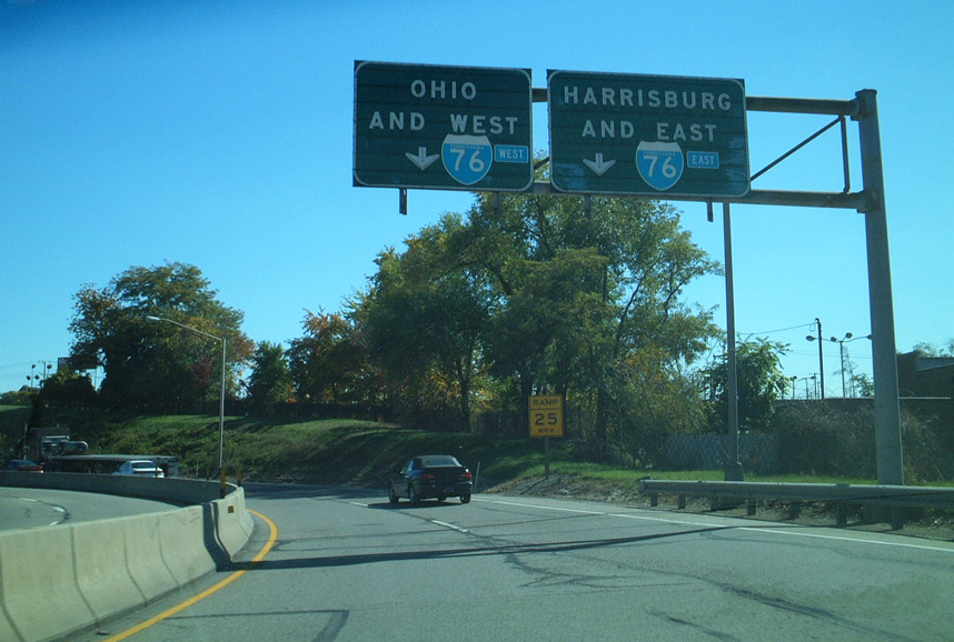
A trumpet interchange joins the I-376 access road with Interstate 76 (Pennsylvania Turnpike) leading northwest to Youngstown, Ohio and east to the capital city of Harrisburg. Green outs updated the sequential exit numbers here when the state converted to mileage based exits. 10/14/01
West End  – Sharon, Pennsylvania
![]() West at
West at ![]()
![]()
The first sign for Interstate 80 (Exits 1B/A) on I-376 west appears within the diamond interchange (Exit 2) at PA 18 outside West Middlesex. 06/10/10
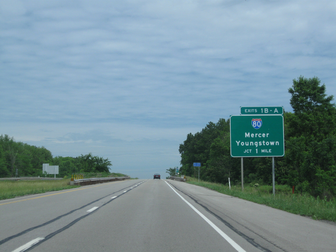
Forthcoming Interstate 80 travels a rural route for 311 miles across northern Pennsylvania, joining smaller cities, boroughs and towns east of Sharon including Mercer, Clarion, Dubois, Bloomsburg and Stroudsburg. 06/10/10
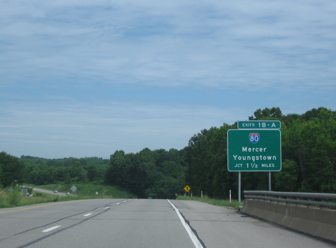
The half diamond interchange with PA 318 just south of I-80 was expanded to include new access from I-376. A $4.949 million contract built a new ramp at Exit 1C from March 10 to October 2014.15 Exit 1B follows just to the north for I-80 east to the nearby Mercer County seat. 06/10/10

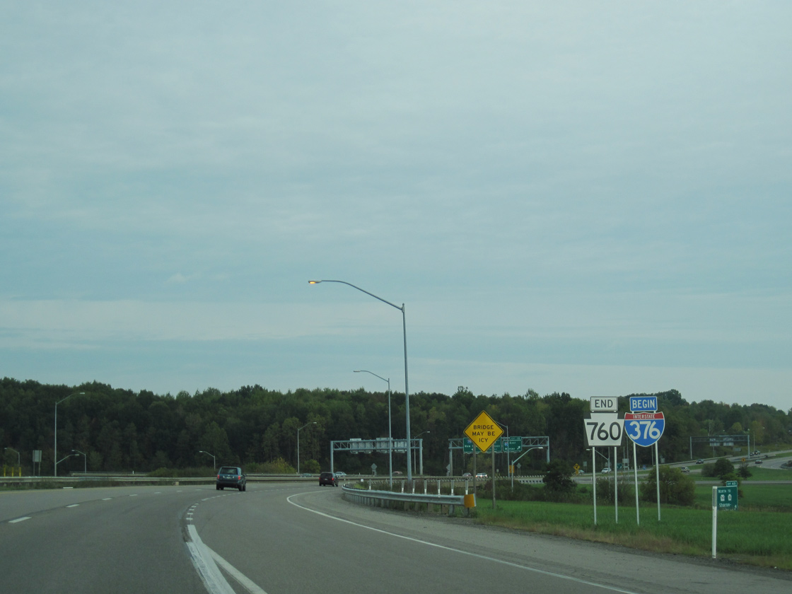
An end I-376 and begin PA 760 shield assembly stands within the cloverleaf interchange at Interstate 80. PA 760 replaced the northernmost extent of PA 60 when I-376 was designated in 2009. 06/10/10
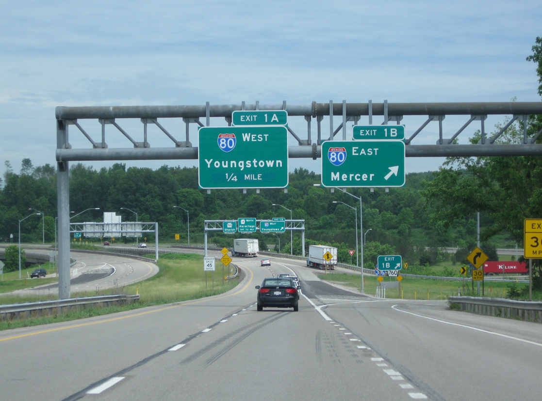
Exit 1A loops away from the ending Interstate 376 to I-80 west for Youngstown, Akron and Cleveland, Ohio. PA 760 curves sharply west to adjacent PA 18 south of the city of Hermitage. 06/10/10
![]() South at
South at ![]()
![]()
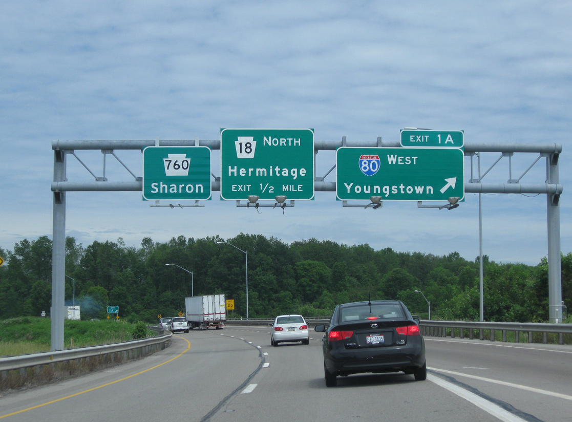
PA 760 transitions from two lane road into a freeway at the parclo interchange with PA 18 in Hermitage. The route quickly enters the cloverleaf interchange from there with I-80 and I-376. 09/30/10
Interstate 376 takes over for the ending PA 760 along the Beaver Valley Expressway leading south to New Castle. 09/30/10
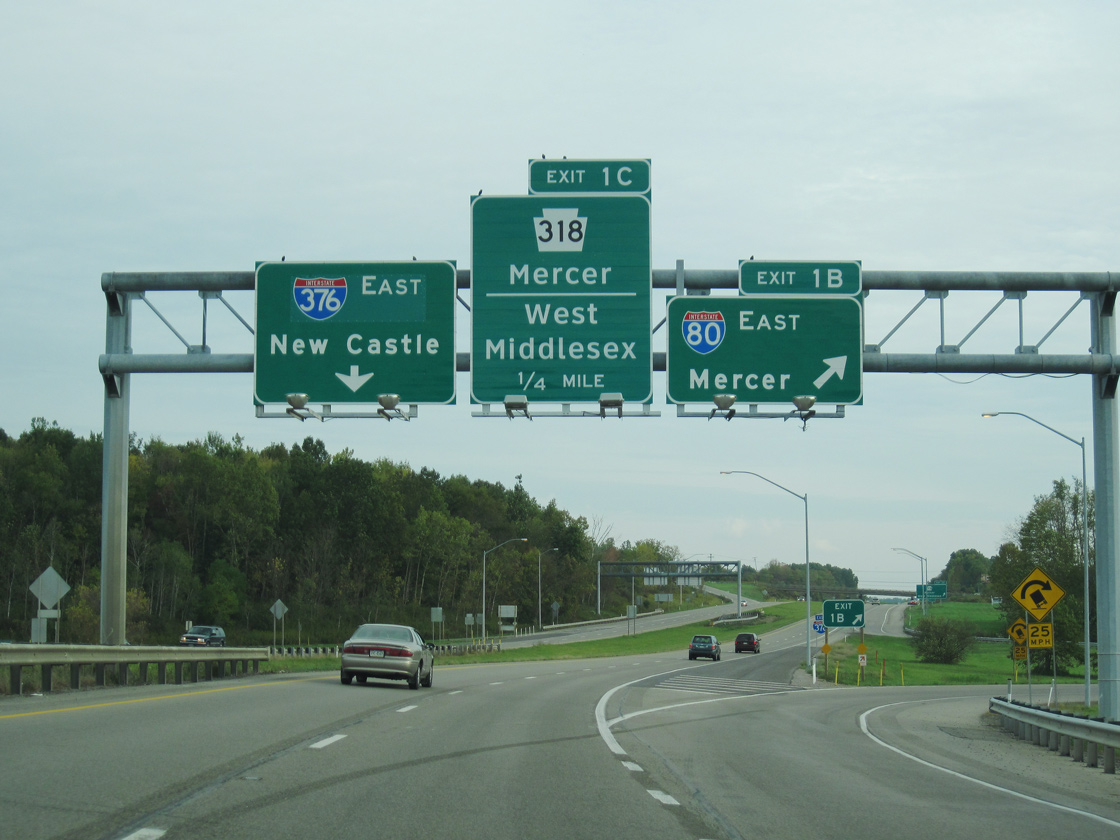
Exits 1B and 1C depart in quick succession from the initial stretch of I-376 east for Interstate 80 east to Mercer and State College and PA 318 into the nearby borough of West Middlesex. 09/30/10
![]() West at
West at ![]()
![]()

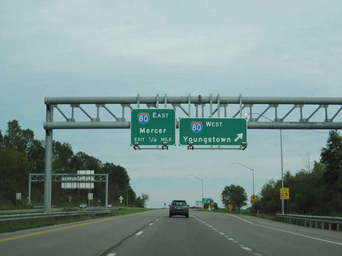
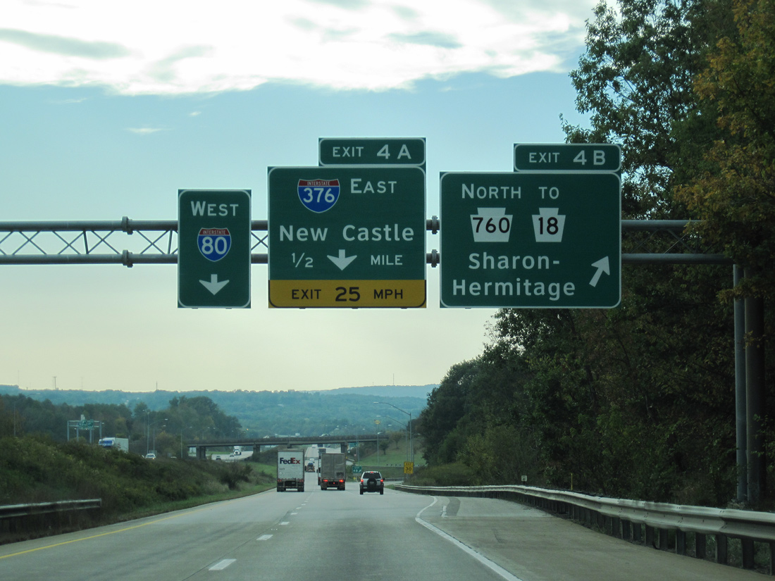
Two miles ahead of Exit 4 for PA 760 north to Sharon and Interstate 376 south to New Castle on I-80 west. 09/30/10
PA 318 passes under Interstate 80, a mile ahead of the cloverleaf interchange (Exits 4B/A) with I-376 and PA 760. I-376 and PA 318 meet just south of I-80 by the borough of Middlesex. 09/30/10
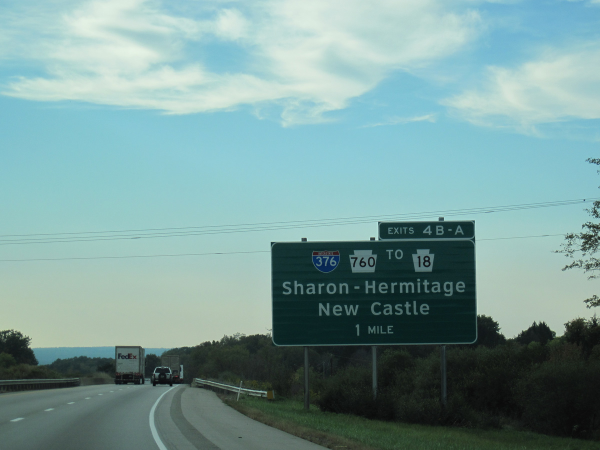
PA 760 spurs north from Interstate 376 as a freeway to nearby PA 18 (Hermitage Road), and a surface route from PA 18 into the city of Sharon. 09/30/10
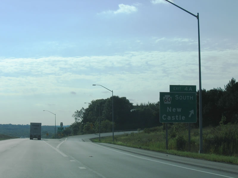
Exit 4A loops onto Interstate 376 (former PA 60) south. I-376 follows the Beaver Valley Expressway to New Castle, Beaver, Moon Township and Pittsburgh International Airport (PIT). 09/01/05
Historic West End –  – Pittsburgh, Pennsylvania
![]()
![]()
![]() Penn Lincoln Parkway East west at
Penn Lincoln Parkway East west at ![]()
Beyond the Smithfield Street overpass, I-376/U.S. 22-30 west approached Exit 1B for Stanwix Street, which connects to the western end of the Purple Belt encircling Downtown Pittsburgh. This button copy sign was carbon copied with Clearview font to display Interstate 376 west in 2009. 11/01/04
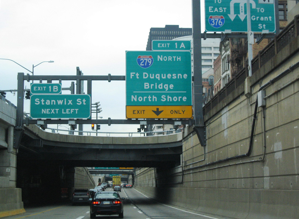
A third westbound lane accompanied I-376/U.S. 22-30 west from the Grant Street on-ramp. Back to back ramps followed for Stanwix Street (Exit 1B) and Interstate 279 north (Exit 1A). This configuration is the same for I-376 today, but with new exit numbers (Exits 70D/C). 11/01/04
Exit 1B ascended from Interstate 376 west as the last off-ramp for Downtown. Penn Lincoln Parkway East continued to I-279 and the Fort Pitt Bridge. 11/01/04
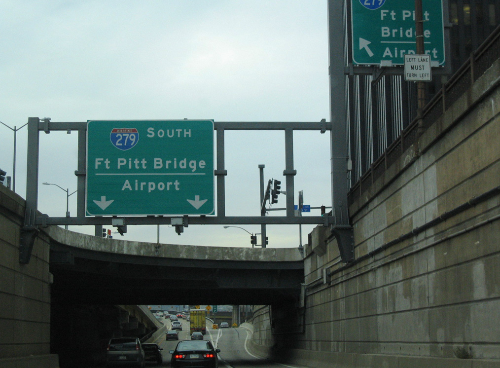
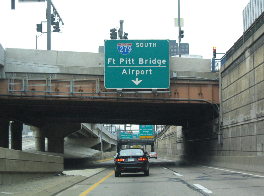
U.S. 22/30 transitioned from the ending I-376 west onto I-279 south across the Fort Pitt Bridge to Mount Washington. Sign replacements made by 2009 continue to omit the US routes, but added an exit only sign for I-279 north (Exit 70C). 11/01/04
I-376 west concluded with narrow ramps to Interstate 279. The overhead for I-279 here was renumbered to Exit 70C but otherwise carbon copied. The remainder of I-279 follows its original route to North Shore destinations via the Fort Duquesne Bridge. 11/01/04
A pair of end shields were posted on the transition ramp from I-376 west to the Fort Pitt Bridge (I-279 south) until 2009. The end banners were replaced then with west banners. Prior to 2002, both assemblies included state-named shields. 11/01/04
![]() Penn Lincoln Parkway North – South at
Penn Lincoln Parkway North – South at ![]()
![]()
![]()
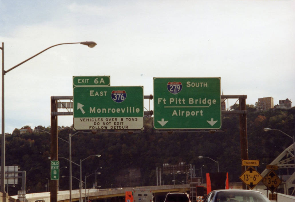
Interstate 279 south at I-376/U.S. 22-30 (Penn Lincoln Parkway East) was numbered as Exit 8 originally, then Exit 6 A when mile based exits were implemented across the Keystone State. With the truncation of I-279 here, the left exit ramp for Monroeville is now unnumbered. 10/14/01
Reconstruction of the Fort Pitt Bridge and an adjacent section of Parkway West through 2003 replaced this stretch of viaduct taking travelers from the Fort Duquesne Bridge south onto the then-eastbound beginning of Interstate 376. 10/14/01
![]()
![]()
![]() Penn Lincoln Parkway West – North at
Penn Lincoln Parkway West – North at ![]()
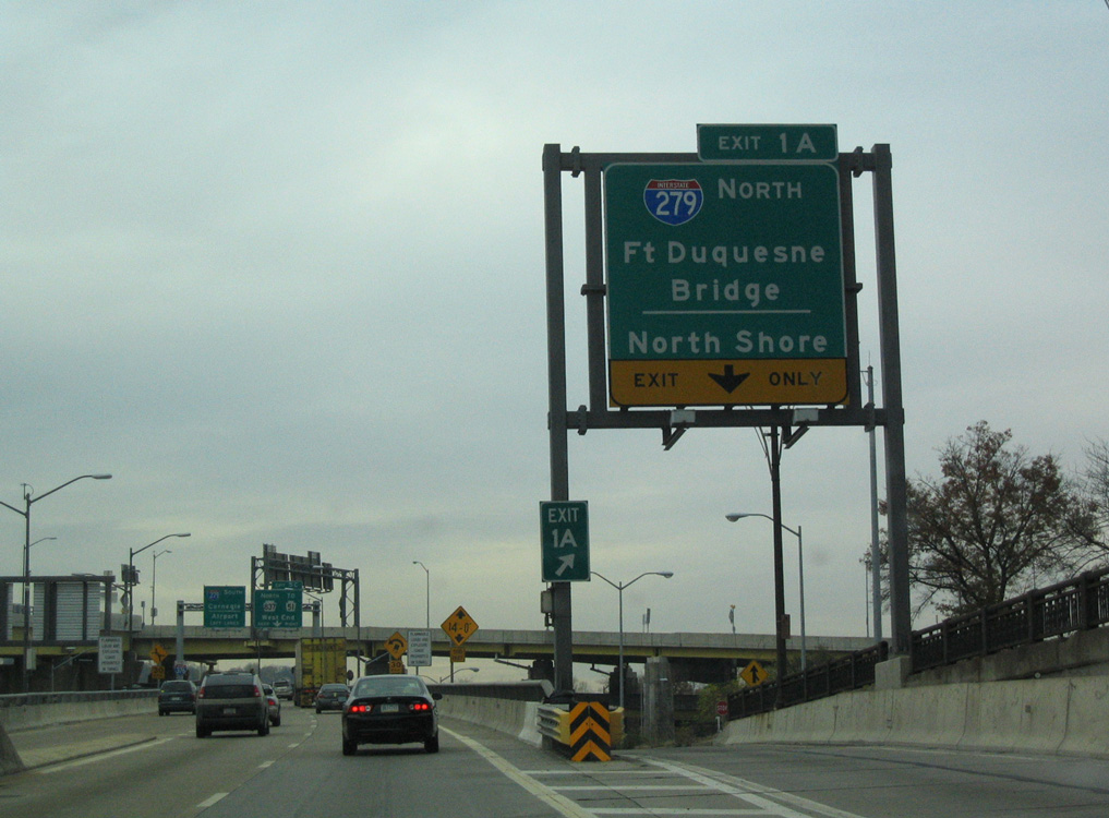
Interstate 279 split with the eastbound beginning of I-376 just beyond the forthcoming Fort Pitt Tunnel. Following the renumbering of Parkway West to Interstate 376, exits were renumbered and the pull through panel for I-279 was replaced with a one mile sign referencing North Shore. 10/28/04
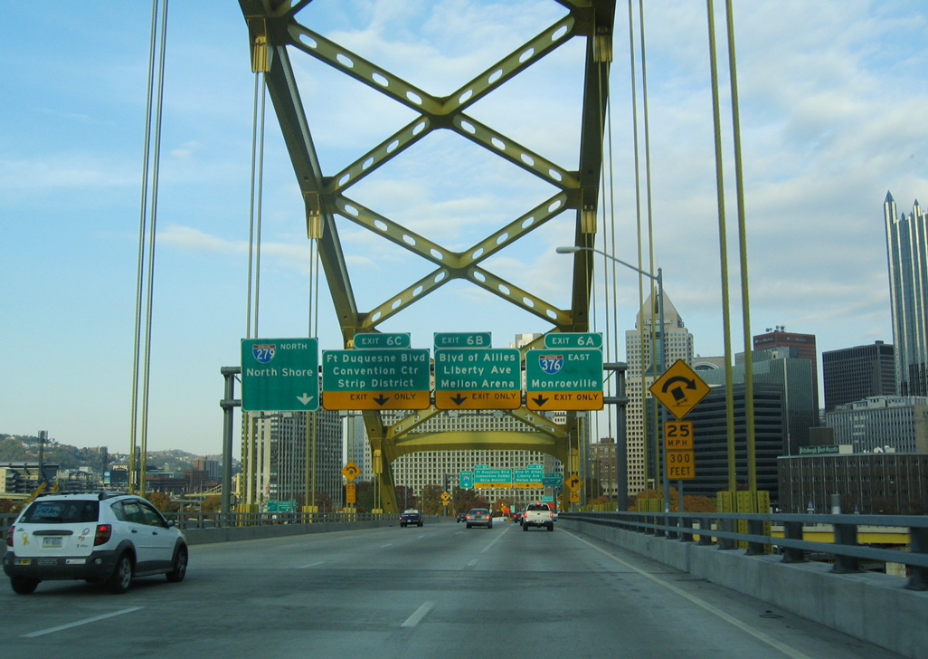
Northbound I-279/U.S. 22-30 traveled the upper deck of the Fort Pitt Bridge directly east from the Fort Pitt Tunnel to Exit 6A for I-376 (Penn Lincoln Parkway East) and two Downtown / Golden Triangle exits. Sign changes here added an exit only placard for I-279 north (now Exit 70C) and two pull through arrows for I-376 east. 10/28/04
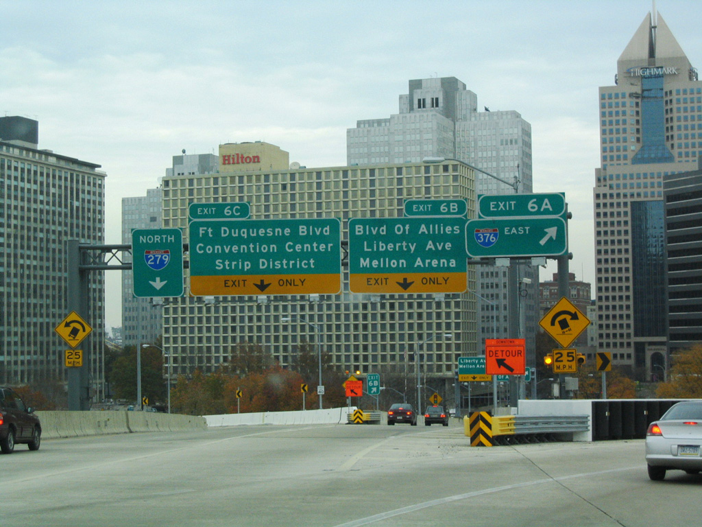
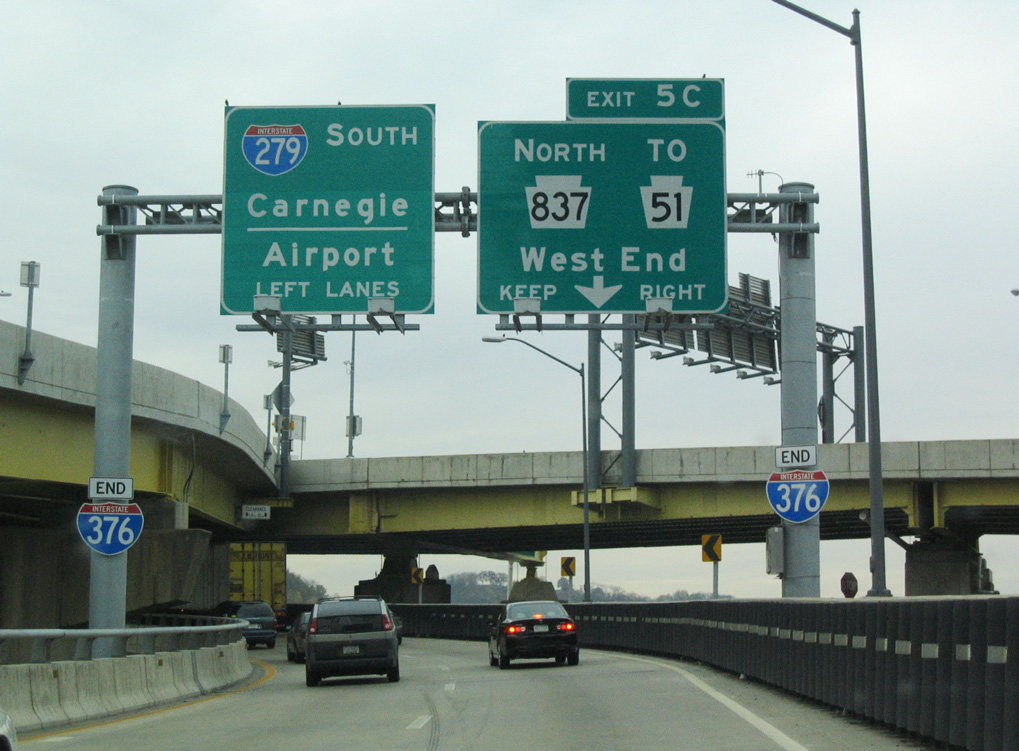
The Fort Pitt Bridge partitioned with two lanes for I-376/U.S. 22-30 east (Exit 6A), a single lane for Boulevard of the Allies (Exit 6B) and two lanes for I-279 north and the off-ramp (Exit 6C) for Fort Duquesne Boulevard. This configuration remains the same with I-376 as the through route and ramps renumbered to Exits 70C-A. 11/01/04
Sources:
- “250 Years of Pittsburgh History.” Pittsburgh Post-Gazette (PA), March 18, 2008.
- Pennsylvania Highways: Interstate 376.
- Fort Pitt Tunnel – Bridges and Tunnels of Allegheny County and Pittsburgh, PA (Bruce S. Cridlebaugh).
- “Tunnel Fun Facts.” Pittsburgh Post-Gazette (PA), March 31, 2002.
- Squirrel Hill Tunnel – Bridges and Tunnels of Allegheny County and Pittsburgh, PA (Bruce S. Cridlebaugh).
- “Cost to unify I-376 pieces into one: $91 million”, Pittsburgh Post-Gazette (PA), May 17, 2005.
- “Feds close to ruling on making road I-376.” Pittsburgh Post-Gazette (PA), May 16, 2004.
- “Plan to turn 60 miles of roads into I-376 advances.” Pittsburgh Post-Gazette (PA), September 18, 2003.
- “PennDOT says cost for I-376 redesignation reduced”, Pittsburgh Post-Gazette (PA), March 20, 2006.
- “Parkway West becomes Interstate 376.” Pittsburgh Post-Gazette (PA), June 10, 2009.
- “Changing signs do a number on Parkway West drivers.” Pittsburgh Post-Gazette (PA), July 16, 2009.
- “It’s Official: I-376 Corridor Christened.” Pittsburgh Post-Gazette (PA), November 7, 2009.
- “PennDOT’s Route 22/30/60 Interchange Reconstruction Earns Diamond Award Certificate for Engineering Excellence.” Pennsylvania Department of Transportation, press release. March 5, 2012.
- “Effective August 1 New Signage Marks Turnpike 60 Conversion to I-376.” Pennsylvania Turnpike Commission, press release. July 26, 2010.
- “Interstate 376, Route 318 Ramp Construction to Begin in Mercer County.” Pennsylvania Depart of Transportation, press release. March 5, 2014.
Page updated January 13, 2020.