Interstate 264 Virginia

Overview
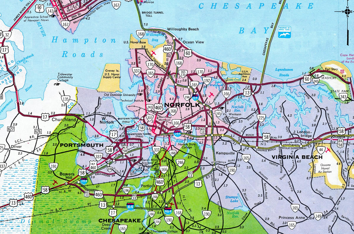
Interstate 264 in Virginia is an urban freeway paralleling U.S. 58 between Chesapeake and Virginia Beach in the Hampton Roads region. The eastern leg of the route is the Virginia Beach-Norfolk Expressway, a former toll road spurring east from I-64 (Hampton Roads Beltway) to Naval Air Station Oceana and the Virginia Beach Oceanfront. I-264 serves commuter interests from Suffolk east into Portsmouth and from Virginia Beach west into Norfolk.
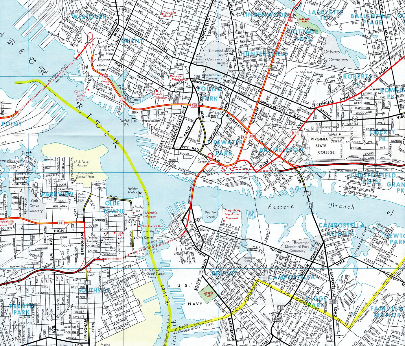
The tolled Downtown Tunnel carries Interstate 264 across the Elizabeth River Southern Branch between Downtown Portsmouth and Berkley in Norfolk. The Berkley Bridge, a double-leaf bascule bridge with a vertical navigational clearance of 50 feet,1 takes the route north from Washington Point to Downtown Norfolk over the Elizabeth River Eastern Branch. Further east, a lengthy collector distributor roadway system separates mainline traffic from ramps to U.S. 13 (Military Highway), Interstate 64 (Hampton Roads Beltway) and Newtown Road on the Virginia Beach and Norfolk city line.
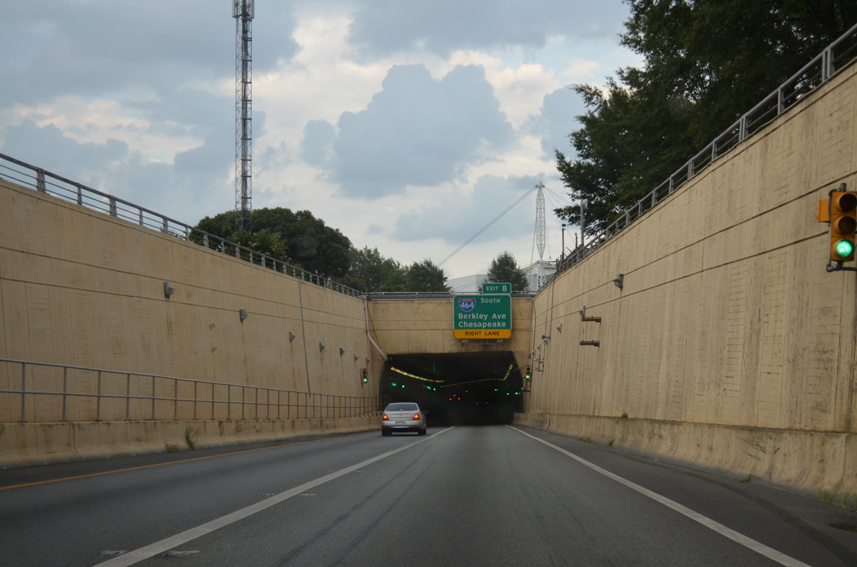
Entering the Downtown Tunnel along Interstate 264 eastbound. The eastbound tube starts at Court Street, while the westbound bore emerges a bit further east below Pavilion Drive. 07/28/13
 History
Originally planned as a route through Downtown Norfolk, most of the freeway was complete by 1972 with the exception of the Downtown Tunnel and Berkley Bridge. The Elizabeth River crossings between the cities of Norfolk and Portsmouth opened in 1952 with two lanes through the tunnel and four lanes on an undivided bridge. Federal Interstate funding, covering 90% of the costs, was approved to upgrade the 2.2 mile long bridge and tunnel complex in 1978.
Work involving construction of a second bore for the Downtown Tunnel, interchange upgrades, and a second four lane bridge over the Elizabeth River Eastern Branch commenced in 1982. Costing $18.5 million, the new tube for the Downtown Tunnel encountered construction delays for seven months. The opening date was pushed back from August 1, 1986 due to problems including a water leak and delays in installing electrical equipment. The revised target date for completion shifted to February 28, 1987, but ventilation fans failed to work properly, further offsetting the planned opening to March 7. The fans were repaired and the tunnel opening advanced to March 4, 1987 because of forecasted clear weather. When the new tunnel opened, the adjacent 1952 tunnel closed for a year long renovation project.2 It reopened in conjunction with the Berkely interchange and north end of Interstate 464 following a ceremony held on December 20, 1988.3
Construction continued with a new entrance ramp opening from Waterside Drive to Interstate 264 east on April 9, 1990. This eliminated the old entrance ramp and a contraflow lane.4 Adjacent work on the $41 million second Berkley Bridge continued to May 24, 1990, when eastbound traffic along I-264 shifted to the new span. The old Berkley Bridge was redesigned for westbound I-264 on the same day. Follow up work in 1991 closed the 1952 bridge for reconstruction.5 The refurbished bridge and an additional portion of the Downtown interchange opened to traffic on June 27, 1991.6
Virginia Beach-Norfolk Expressway
Measuring 12.8 miles in length, the Virginia Beach-Norfolk Expressway opened with four lanes in 1967. Construction in the 1980s expanded the toll road to six lanes, with subsequent work in the early 1990s adding two additional lanes. Toll revenue bonds for the expressway were completely paid off and tolls were removed in 1995.1
Virginia requested an extension of Interstate 264 along State Route 44 at the American Association of State Highway and Transportation Officials (AASHTO) meeting on November 14, 1997, after previous discussions in the works since 1996. The extension was sought by Virginia Beach to further attract businesses to a city that previously was served by just two miles of I-64. The request was approved by AASHTO, but subject to Federal Highway Administration (FHWA) approval. FHWA concurred with the redesignation in early February 1999.11 Sign changes were made starting on May 3, 1999, when crews began swapping out SR 44 signs for I-264 shields.12
Downtown Tunnel Tolling
The Downtown and Midtown Tunnels linking Portsmouth and Norfolk were tolled until August 1, 1986. Funds collected over a 34 year period for the Downtown Tunnel and nearly 24 years for the Midtown Tunnel amounted to $149.2 million. This money redeemed the bonds to pay for the original tunnel construction, cover operation and maintenance costs and pay for a refurbishment project on the Midtown Tunnel completed by 1988. The tunnels were paid for on August 1, 1984, and legislation passed by the 1986 General Assembly mandated their removal two years after the debts were paid off.7
Tolls returned to the Downtown Tunnel on February 1, 2014. Funds generated from the All Electronic Toll (AET) collection pay for improvements to the Downtown Tunnel, extension of the Martin Luther King Expressway south from London Boulevard to I-264, and expansion of the Midtown Tunnel with a new two lane bore. Rates are variable, with higher fees charged during peak hours (5:30-9 AM) and (2:30-7PM). Tolls were increased on January 1, 2015.8,9
Route Information
East End – Virginia Beach, VA
West End – Chesapeake, VA
Mileage – 25.07
Cities – Portsmouth, Norfolk, Virginia Beach
- Junctions –


Source: December 31, 2021 Interstate Route Log and Finders List
I-264 Annual Average Daily Traffic (AADT)
Source: 2016 VDOT Traffic Volume
Interstate 264 west from SR 141 (Effingham Street) to Military Highway and east from Brambleton Avenue was open traffic by December 1967.4
Excluding the Elizabeth River Branch crossings upgrade, the last segment of Interstate 264 built in Hampton Roads was the portion west from Brambleton Avenue to the Berkley Bridge. It opened in July 1972.4
 Photo Guides
East End – 21st/22nd Streets – Virginia Beach, Virginia
![]() East
East

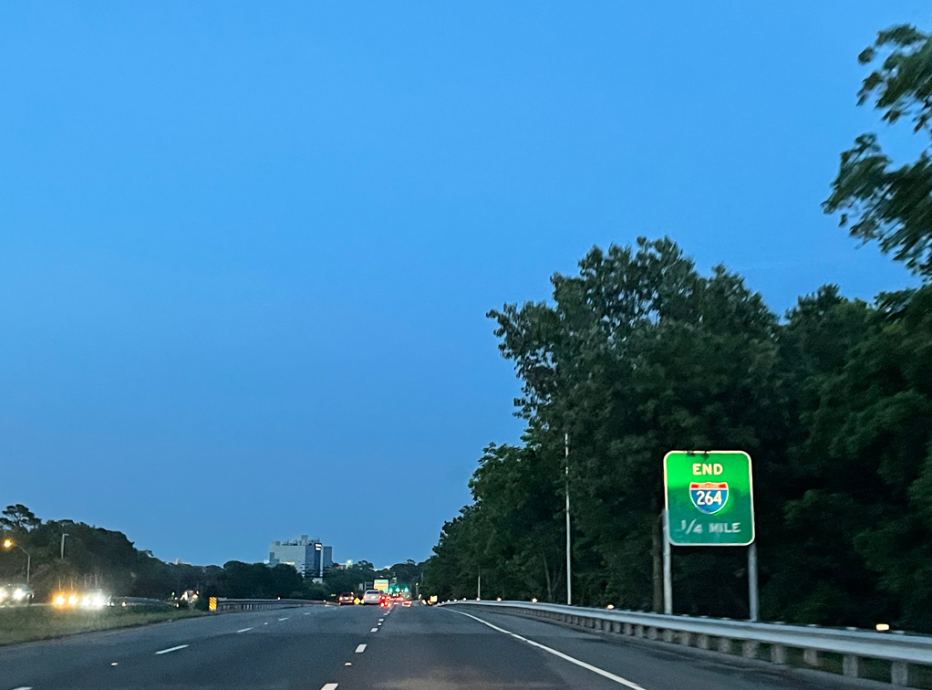
Interstate 264 (Virginia Beach-Norfolk Expressway) concludes one mile east of Great Neck Creek. 12/14/17

Beyond the exchange (Exit 22) with Birdneck Road, the roadways for I-264 separate leading to the couplet of 21st and 22nd Streets. 12/14/17
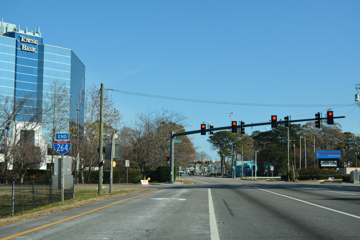
Replaced by 2016, the previous end sign for Interstate 264 was posted in 2002. Photo by Will Weaver (11/22/09).
Replacement end signage for I-264 added by 2016. Photo by Peter Johnson (06/06/21).

Speed limits decrease to 35 miles per hour as Interstate 264 transitions to 21st Street east between the Virginia Beach Information Center and Virginia Beach Convention Center. 12/14/17
An end shield for I-264 precedes the traffic light with Parks Avenue. 21st Street (SR 903) extends 0.60 miles east to Atlantic Avenue (SR 901) at the Virginia Beach business district. 12/14/17

A second end shield stands along the south side of 21st Street at Parks Avenue. 03/01
22nd Street – West at ![]()
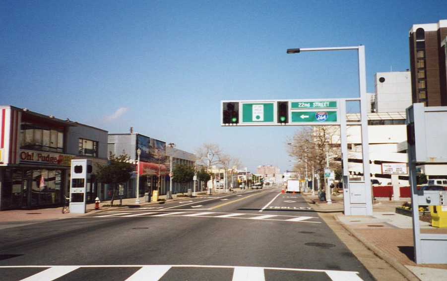
Atlantic Avenue (SR 901) north at 22nd Street west. 22nd Street (SR 903) transitions to Interstate 264 in six blocks. 03/01

The internally lit street sign for 22nd Street west with a state named shield above Atlantic Avenue north was replaced by 2014. 03/01

22nd Street (SR 903) proceeds west from Atlantic Avenue one block to U.S. 60 (Pacific Avenue). Interstate 264 begins in 0.53 miles. 12/14/17

Parks Avenue north at 22nd Street and the westbound beginning of Interstate 264. 12/14/17

Interstate 264 (Virginia Beach-Norfolk Expressway) extends 25.21 miles west from 22nd Street and Parks Avenue to I-64 at Bowers Hill. 12/14/17

The concrete roadway for Interstate 264 west from 22nd Street was paved with asphalt after 2011. 03/01
West End 
 – Chesapeake, Virginia
![]() West at
West at ![]()
![]()
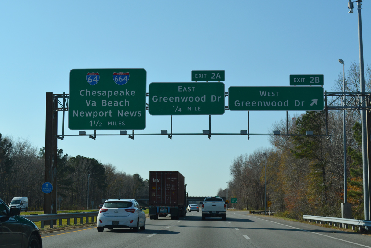
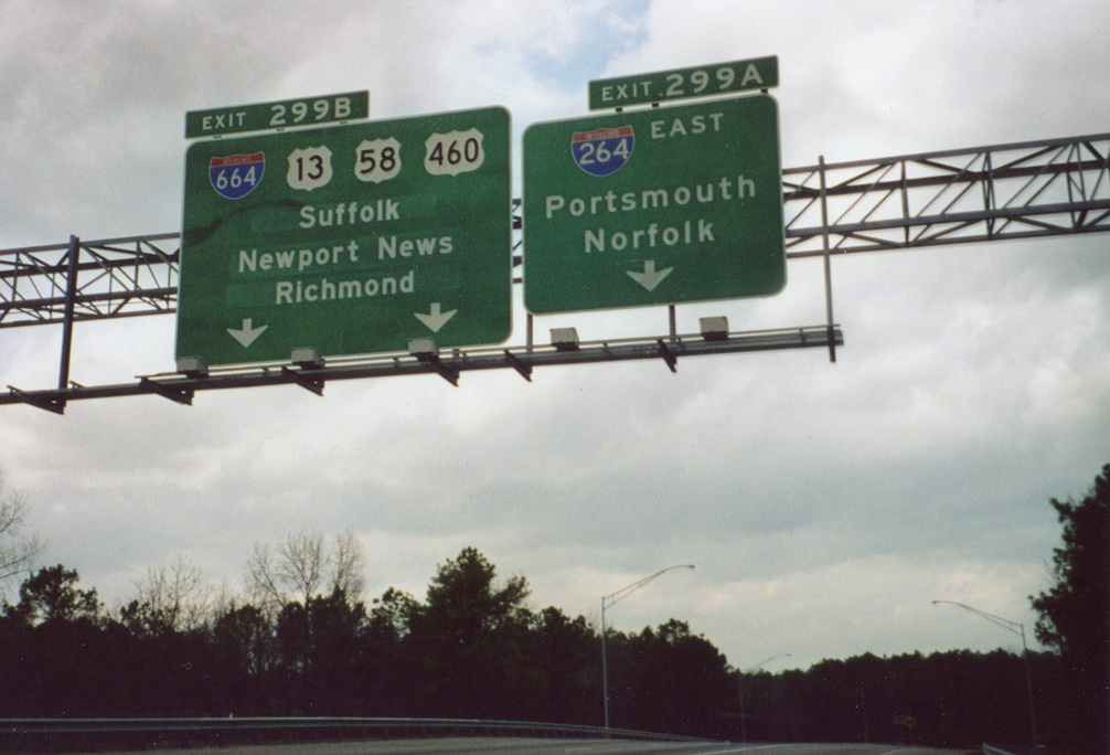
Interstate 264 leads southwest from the cloverleaf interchange (Exit 2) with Greenwood Drive 1.5 miles to end at a three-wye interchange with I-64 and I-664 north. 12/14/17

U.S. 13-58-460 tie into Interstate 664 just beyond I-264 at Bowers Hill. Crossing the Monitor Merrimac Memorial Bridge Tunnel, I-664 (Hampton Roads Beltway) reaches Newport News in 14.7 miles. 12/14/17

A left exit ramp joins I-264 west with Interstate 64 leading southeast back toward Chesapeake. The I-264 mainline defaults onto I-664 north to Bowers Hill and Suffolk. 12/14/17

An end sign for I-264 west stands along the transition to Interstate 664 north. 12/14/17
![]() South at
South at ![]()
![]()

Traffic merges onto Interstate 664 south from U.S. 13-58-460 east ahead of the three wye interchange (Exits 15A/B) with I-264 east and I-64. 07/28/13
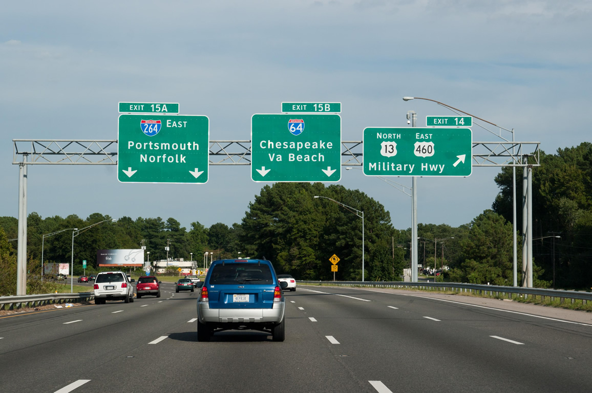
I-664 (Hampton Roads Beltway) advances east with three overall lanes from Exit 14 (Military Highway) to the split for I-264 east and Interstate 64. Photo by Will Weaver (09/05/10).
West End Throwback

These guide signs one half mile from the west end of I-264 were replaced in kind with Clearview font based overheads. 12/17/01
Interstate 64 concludes with two lanes continuing the Hampton Roads Beltway onto I-664 north and a single lane ramp for I-264 east into Portsmouth. 03/01

An end shield for I-64 stands along the exit ramp to the eastbound beginning of Interstate 264. 03/01
Sources:
- Hampton Roads Area Interstates and Freeways, Roads to the Future web site (Scott Kozel).
- “Tolls on Two Tunnels to End.” Richmond Times-Dispatch (VA), July 29, 1986.
- “After Delays, Tunnel to open in Portsmouth.” Richmond Times-Dispatch (VA), March 4, 1987.
- “Downtown Tunnel Officially Reopened after Renovation.” Richmond Times-Dispatch (VA), December 21, 1988.
- “New Waterside Ramp to I-264 to Open.” Virginian-Pilot, The (Norfolk, VA), April 7, 1990.
- “2nd Berkley Bridge Will Open this Morning.” Virginian-Pilot, The (Norfolk, VA), May 24, 1990.
- “Twice as Nice: At Long Last, It’s Berkley ‘Bridges,’ Plural.” Virginian-Pilot, The (Norfolk, VA), June 26, 1991.
- “Tolls now in effect at Downtown, Midtown Tunnels.” WTKR TV-3 (Norfolk, VA), January 31, 2014.
- “New toll rates in effect at Downtown, Midtown tunnels.” 13NewsNow (WVEC – Hampton, VA), January 1, 2015.
- I-264, Virginia Highways Project.
- “Expressway Renamed< Big Improvement< Final Approval Has Been Granted to Change Route 44 to I-264.” Virginian-Pilot, The (Norfolk, VA), February 6, 1999.
- “Next Week: HOV Access to Expand, Route 44 to become Interstate 264.” Virginian-Pilot, The (Norfolk, VA), April 29, 1999.
Page updated July 14, 2021.