Interstate 169 Texas

Overview
Interstate 169 overlays the westernmost 4.41 miles of SH 550, an 11.69 mile long toll road linking IH 69E/U.S. 77-83 in north Brownsville with SH 48 and the Port of Brownsville. Known as The Gap I and Gap II projects, construction along the two remaining portions of SH 550 kicked off in Winter 2016. Work finishes the expressway mainline between the companion frontage roads.5 The Gap I project was completed in June 2018. The Gap II project completes SH 550 from a point 0.2 miles south of FM 1847 to a point 1.13 miles south of the Union Pacific Railroad. Letting for construction of the estimated $21,072,00 million project was September 2021.
A group of Texas dignitaries gathered at the intersection of Baker Lane and Frontage Road by the SH 550 toll road to unveil the first sign for Interstate 169 on February 16, 2016.6 When the entire toll road is completed, SH 550 will be resigned as IH 169. Until that time, IH 169 is partially signed, sometimes as SH 169.
 History
The American Association of State Highway and Transportation Officials (AASHTO) approved the establishment of Interstate 169 at the Route Numbering Committee Meeting held on May 15, 2015. The U.S. Department of Transportation followed on November 5, 2015,5 and the Texas Transportation Commission approved 1.5 miles of IH 169 at their meeting on December 17, 2015. Managed by the Cameron County Regional Mobility Authority, SH 550 was developed to improve access to the Port of Brownsville and associated industrial areas to the east of Brownsville. The toll road overlays the route of FM 551.
The initial 1.9 mile long segment of the toll road opened on March 10, 2011 with new travel lanes and overpasses above FM 1847 (Paredes Line Road) and a Union Pacific Railroad line. This section of infrastructure cost $10 million and was untolled until May 10, 2011.1
Work continued on the second phase of SH 550, a 3.01 mile long stretch named the Port Spur. The $34 million project constructed new roadway from FM 3248 southeast to SH 48 (Brownsville-Port Isabel Highway) and a new main entrance to the Port of Brownsville. A ribbon cutting ceremony was held for the Port Spur on May 29, 2013.1,3 The SH 550 Port of Brownsville entrance opened following another ribbon cutting event held on February 19, 2014.4
Phase three of SH 550 consists of building the remaining portions of the expressway mainline and their companion frontage road system. This includes work to build a high speed interchange with IH 69E/U.S. 77-83.1 $44 million in construction on phase three commenced in March 2013, with direct connectivity between IH 69E and the Port established in January 2015.2
AASHTO conditionally approved a 0.4 mile extension of IH 169 east from FM 1847 (Old Alice Road) to the limits of access control on May 21, 2019.
Route Information
East End – Brownsville, TX
West End – Brownsville, TX
Mileage – 4.00
Cities – Brownsville
- Junctions –

Source: December 31, 2021 Interstate Route Log and Finders List
I-169 Annual Average Daily Traffic (AADT)
| Location | Vehicles per day |
|---|---|
| east of IH 69E | 18,107 |
| west of FM 1847 | 20,237 |
| east of FM 1847 | 18,347 |
| west of FM 3248 | 14,826 |
| east of FM 511 | 2,440 |
| north of SH 48 | 2,760 |
Source: 2020 AADT – TxDOT Statewide Planning Map
East End  – Brownsville, Texas
The current east end of IH 169 is located 0.4 miles east of Old Alice Road in north Brownsville. The east end will eventually be at the diamond interchange joining SH 550 with SH 44 and the Port of Brownsville main entrance.
![]() South at
South at ![]()

Entering the diamond interchange with SH 48 on SH 550 south. 08/03/19

SH 48 extends 21.94 miles east from U.S. 281 in Brownsville to SH 100 at Port Isabel. 08/03/19
![]() East at
East at ![]()

SH 48 crosses a Brownsville & Rio Grande International Railroad line east between FM 511 (Indiana Avenue) and SH 550 north. 08/03/19


SH 48 eastbound at the ramp for SH 550 north and Ray Windhaus Road south to the Port of Brownsville. 08/03/19
![]() North
North

Ray Windhaus Road connects with the south end of SH 550 at the exchange with SH 48. The SH 550 toll road commences just to the north. 08/03/19
Crossing the Rancho Viejo Floodway, SH 550 splits with a frontage road ahead of the western turn across the Brownsville & Rio Grande International Railroad. 08/03/19

The frontage road system for the SH 550 toll road is marked as SH 550. The southern segment constitutes a turnaround ahead of the forthcoming railroad underpass. 08/03/19
West End  – Brownsville, Texas
![]()
![]() North at
North at ![]()
![]()
![]()

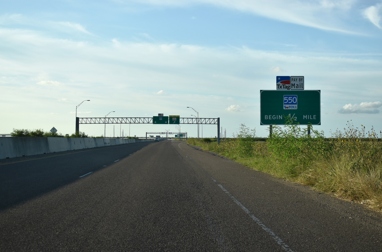
IH 169 ends at IH 69E/U.S. 77-83 on the north side of Brownsville. There is no direct access to IH 69E/U.S. 77-83 south to central Brownsville from the north end of SH 550/IH 169. 08/03/19

An end toll road sign appears along the flyover linking SH 550/IH 169 northbound with IH 69E/U.S. 77-83 north to Harlingen, McAllen and Raymondville. 08/03/19


High speed flyovers link southbound IH 69E with IH 169 and from IH 169 to IH 69E north. The remaining movements utilize the frontage roads of both highways. 08/03/19
![]()
![]()
![]() South at
South at ![]()

A direct connect flyover joins IH 69E/U.S. 77-83 south to the SH 550 toll road at Exit 10 B. 08/03/19

Succeeding ramps depart IH 69E/U.S. 77-83 southbound for the SH 550 frontage road system and FM 511 (Exit 10 A) and the SH 550 toll road (Exit 10 B). 08/03/19
![]()
![]()
![]() North at
North at ![]()

IH 69E travels 9.8 miles north from University Boulevard and East Avenue, just beyond the port of entry, to SH 550 and IH 169 at Exit 10 A. 08/03/19

Exit 10 A joins IH 69E/U.S. 77-83 northbound with the SH 550 frontage road system to FM 511 and the SH 550 toll road south. 08/03/19
Sources
- “SH 550: A direct connection to international trade.”
http://www.bedc.com/news/ sh-550-direct-connection-international-tradeBrownsville Economic Development Council, December 17, 2013. - “Big money transportation projects make gains in 2014.” The Herald (Brownsville, TX) January 2, 2015.
- “S.H. 550 ribbon-cutting crowd gets big I-69 news.” The Herald (Brownsville, TX) May 29, 2013.
- “Port of Brownsville – New State Highway 550 connector entry opens.” The Herald (Brownsville, TX) February 20, 2014.
- “SH 550 segment gets new name” The Herald (Brownsville, TX) November 9, 2015.
- “Portion of Cameron County highway gets new designation.” The Monitor (Brownsville, TX), February 16, 2016.
Page updated June 5, 2022.