Interstate 80
Overview
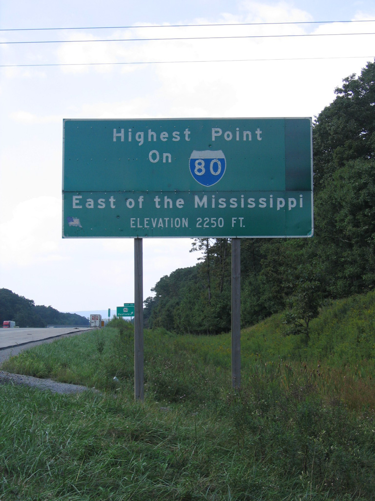
Interstate 80 is a major transcontinental corridor connecting California and New York City. From the city of San Francisco to four miles west of the Hudson River at Teaneck, New Jersey, I-80 traverses various terrain and 11 states. Its highest point is located at Sherman Hill Summit in Wyoming between Laramie and Cheyenne at an elevation of 8640 feet. The highest point of Interstate 80 east of the Mississippi, 2,250 feet above sea level, is near Milepost 111 in Pennsylvania.
Although Interstate 80 begins at U.S. 101 in San Francisco, original plans called for the route to continue west through Golden Gate Park to the Pacific Ocean near the famous Ocean Beach area. This plan was halted due to community opposition.
In the east, I-80 ends at Interstate 95 along the Teaneck Township and Ridgefield Park line in North Jersey. There was some debate as to whether or not I-80 ends at the Hudson River or at Interstate 95. Coincidentally, the exit numbering for I-95 in the Garden State approximates what the I-80 numbering would be if it continued east to the George Washington Bridge. However, that numbering is actually based upon the distance of I-95 had the Somerset Freeway between Trenton and New Brunswick been completed as planned.
Interstate 80 Split Routes
No other Interstate highway had as many split routes as I-80. No fewer than five suffixed routes split from I-80 at varying intervals prior to 1980; none of these split routes remain today. These routes included:
- I-80N from Portland, Oregon, to Echo Junction, Utah (now Western Interstate 84)
- I-80S from Denver, Colorado, to Big Springs, Nebraska (now Western Interstate 76)
- I-80N from Interstate 29 to I-80 north of Council Bluffs, Iowa (replaced by Interstate 680 and I-880)
- I-80S from Norwalk, Ohio, to Camden, New Jersey (the portion between Norwalk and Westfield Center was not constructed; the rest is became Eastern Interstate 76)
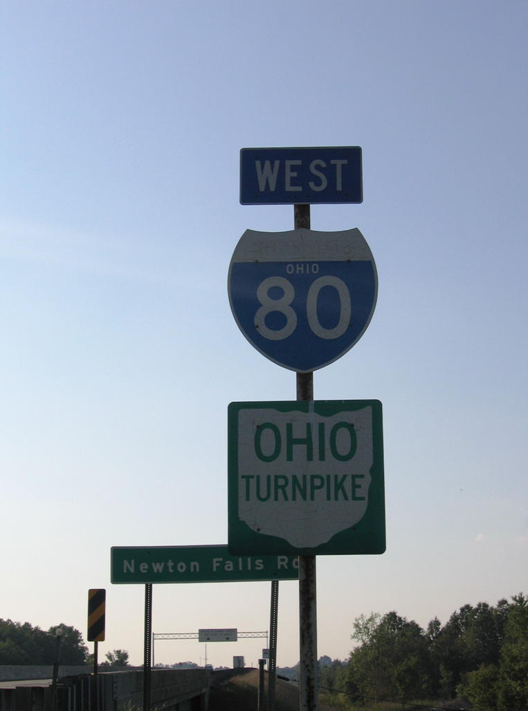
- I-80N from Norwalk, Ohio, to northwest of Youngstown, Ohio (parts of which are Interstate 480)
High Priority Corridor
Interstate 80 in New Jersey is part of High Priority Corridor 63: Liberty Corridor.
 Parallel U.S. Routes
Interstate 80 largely replaced its companion U.S. routes in the West and parallels them in the East. Between San Francisco and Park City, Interstate 80 replaced U.S. 40. Sections of original U.S. 40 are still in use as local county roads in California, while many segments of U.S. 40 in Nevada were directly replaced by I-80. Today, U.S. 40 begins eastward from an interchange with I-80 in Park City. Between Park City and Echo Junction, I-80 replaced U.S. 189 (and U.S. 530 before it). East from Echo Junction to Evanston and southwestern Wyoming, I-80 overlaid the historic route of U.S. 30S. U.S. 30 accompanies the cross country route east from Granger Wyoming to the Midwestern U.S.
U.S. 30 is the Lincoln Highway through Wyoming, Nebraska, Iowa, Illinois, Indiana and Ohio. It closely parallels Interstate 80 in Wyoming and Nebraska, combining with the freeway in the least populated areas (such as the cosigned portion between Granger and Walcott in Wyoming, a distance of 170 miles). Once at Grand Island, Nebraska, U.S. 30 shifts away from the freeway to the north of Lincoln and Omaha; Interstate 80 instead follows U.S. 34 between Grand Island and Lincoln and U.S. 6 from Lincoln to the Quad Cities via Omaha and Des Moines. Additionally U.S. 6 merges with I-80 several times through Iowa, and it closely parallels the freeway through Illinois before joining it again in Lansing.
U.S. 30 and I-80 meet again at Joliet, Illinois. Having avoided Des Moines and the Quad Cities, U.S. 30 heads southeast to avoid Chicago. U.S. 30 continues on this trajectory en route to Fort Wayne, Indiana and Pittsburgh and Philadelphia, Pennsylvania; it does not intersect I-80 again. Interstate 80 instead remains close to U.S. 6 and U.S. 20 as they skirt the southern edge of the Great Lakes. I-80 is tolled through Indiana and Ohio, so the parallel U.S. 6 and U.S. 20 provide free alternate routes.
Bypassing Cleveland to the south, Interstate 80 leaves both U.S. 6 and U.S. 20, as they follow I-90. Leaving the Ohio Turnpike at North Jackson, I-80 briefly parallels U.S. 62 through Sharon. Continuing east past Youngstown, I-80 follows a path that was not previously tread by a U.S. route. This solo route continues for the most part across Pennsylvania on what was designated the Keystone Shortway, with the exception of U.S. 322 from Clarion to State College and a brief merge with U.S. 220 near State College. Finally entering New Jersey, I-80 picks up U.S. 46, a route which is almost entirely located within New Jersey — it never went any farther west than PA 611 (former U.S. 611). U.S. 46 parallels the freeway east to I-95 at Ridgefield Park.
History
California
Within San Francisco, the west end of I-80 was originally proposed to be at Interstate 280, which was briefly considered as part of Interstate 480, in Golden Gate Park. The Western Freeway (I-80) would have originated at U.S. 101 / Central Freeway and traveled west toward the park, straddling Fell Street and Oak Street along the way. Once at the park, the freeway would have entered a major interchange with I-280, making an odd case where a parent route would have ended at one of its branch routes. However, that situation never came to pass. The freeway was never built as a result of substantial protests, and the western end of Interstate 80 was retracted to U.S. 101 / Central Freeway.
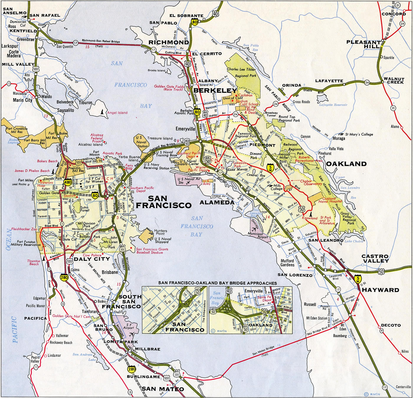
The westernmost alignment proposed for Interstate 80 across San Francisco in 1960. I-480 was envisioned as an urban loop extending west from the Embarcadero double deck freeway to the Presidio and south to I-80.
Since the Central Freeway viaduct was mostly torn down, I-80 concludes at the series of U.S. 101 exits near Van Ness Avenue. This end point is somewhat in dispute; some say that Interstate 80 actually ends at the Embarcadero exit. See the AARoads Guide for Interstate 80 in California for more history and information.
The San Francisco-Oakland Bay Bridge was dedicated on January 14, 1939.9 The bridge initially carried U.S. 40-50 across the bay; it was later redesignated as part of Interstate 80.
The first iteration of the Yolo Causeway, which carries Interstate 80 over the Yolo Bypass west of Sacramento and east of Davis, was completed in 1916. This causeway was the first highway project in the state of California to be financed with the sale of highway bonds; it has been expanded since the original facility opened.
Development of large sections of the freeway along U.S. 40, predecessor to I-80, between San Francisco and Reno occurred by 1947, excepting certain sections including much of the route in the mountains. The first Interstate in California to open using funds designated by the Federal Highway Act of 1956 was Interstate 80. Within the Sierra Nevada northeast of Sacramento, U.S. 40 was converted into I-80 between 1960 and 1964. The first 50 miles were built in 1960, and the ten mile stretch both over Donner Summit and through Truckee River Canyon to the city of Truckee was constructed in 1964.8
San Francisco-Oakland Bay Bridge
The San Francisco-Oakland Bay bridge, opened to traffic on November 12, 1936 as the route for U.S. 40/50, carries Interstate 80 across San Francisco Bay. The span consisted of three segments: the western suspension bridge with four towers, the Yerba Buena Tunnel on Yerba Buena Island, and the eastern cantilever through truss bridge. Earthquake retrofitting between 1994 and 2004 reinforced the suspension bridge west from Yerba Buena Island, bringing the span to current specifications. The eastern span was not reinforced and instead was replaced during an 11 year construction project commencing in 2002. The new Bay Bridge, a single-anchored suspension bridge with a lone tower, opened to traffic on September 2, 2013. This span accommodates side by side traffic rather than a double deck like its predecessor. It ties into a new causeway from the east and includes a bike/pedestrian path to Yerba Buena Island. The old bridge closed on August 28, 2012 and dismantling efforts continue into 2016.
Utah
The last section of Interstate 80 to be completed in any state was the segment west of Salt Lake City, Utah, between Redwood Road and 5600 West. This section was dedicated and opened to traffic on August 22, 1986, and it was the first transcontinental Interstate highway to be completed from coast to coast.7
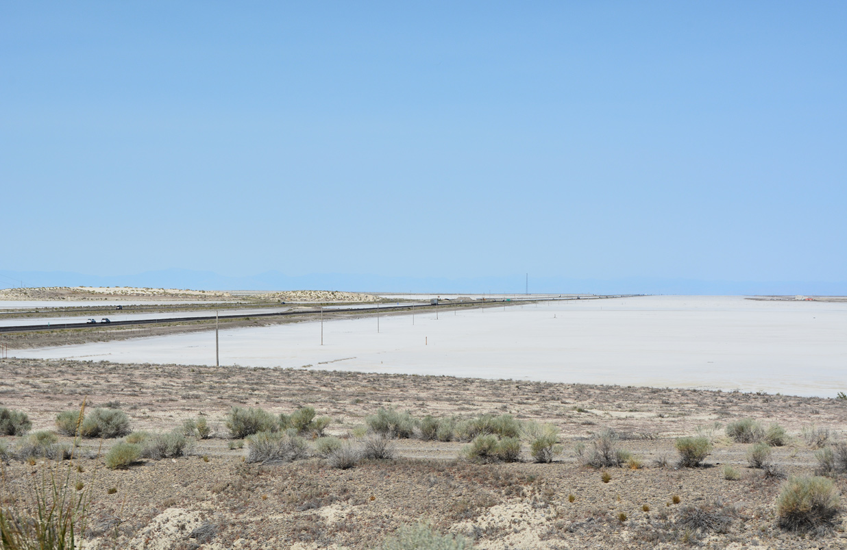
Interstate 80 traverses the wide open expanse of the Great Salt Lake Desert between Wendover and Knolls, Utah. A 36.6 mile exit less stretch ensues west from Old Highway 40 in this scene. 07/03/16
Wyoming
For a history of the completion of Interstate 80 in Wyoming, visit Interstate 80 – Wyoming.
Nebraska
A ribbon cutting ceremony preceded a motorcade led by Governor Frank Morrison on August 12, 1961 to celebrate the completion of Interstate 80 between Omaha and Lincoln. The 52 mile long stretch was dedicated at the Greenwood interchange.14 The final link of Interstate 80 in Nebraska opened was the section around Sidney on October 19, 1974.7
Long range plans originally called for the expansion of Interstate 80 in Nebraska to three lanes from Lincoln west to near Kearney. The project schedule was divided into phases: Phase 1 – between Omaha and Lincoln originally slated for completion by 2012 (final work at Exit 395 wrapped up Spring 2016); Phase 2 – between Lincoln and York originally proposed for completion by 2022; Phase 3 – between York and Grand Island originally proposed for completion by 2028; and Phase 4 – between Grand Island and Minden interchange (Exit 279, N-10) near Kearney originally proposed for completion by 2037.13 Work west of NW 56th Street and Lincoln was not highlighted on the previous Nebraska Department of Roads – I-80 Six Lane Expansion web page as of 2016.
The 45 mile long project widening Interstate 80 from four to six lanes extended from just west of NW 48th Street in West Lincoln (Exit 395) to the N-370 interchange (Exit 439) in West Omaha. The project began in 2002 and was vastly completed on November 8, 201315, with the exception of eastbound lanes at Lincoln and the diverging diamond interchange (DDI) project at NW 48th Street (Exit 395). This work followed previous projects in the late 1990s and early 2000s that widened I-80 to six lanes between N-370 and Interstate 680, and to ten lanes between I-680 and Interstate 480.1
In early 2006, widening to six lanes was completed from Ruff Road (Milepost 429) to N-370 (Milepost 439). Expansion followed between the N-66/Mahoney State Park Interchange (Exit 326) and Ruff Road (Milepost 429). This included rebuilding/widening of the long I-80 twin bridges over the Platte River near milepost 427. As of December 2006, the new three lane westbound bridge over the Platte River was under construction while traffic was maintained on the old twin two lane bridges just to the south. The new eastbound span later opened on January 4, 2008, nine months ahead of schedule, as part of an overall eastbound lane expansion between Mahoney State Park and Ruff Road. Removal of the old bridges and side work continued to Fall 2008. The $45 million project to replace the Platte River bridges started in August 2002.16
Meanwhile, widening to six lanes through northwest of Lincoln between the U.S. 77 South / Beatrice Interchange (Exit 397) and the Interstate 180/U.S. 34 Interchange (Exit 401) was slated for completion in early 2007. Just east of here, widening/rebuilding of the mainline commenced in early 2007 for the section between Interstate 180 and the U.S. 77 North/56th Street Interchange (Exit 405). However, the actual interchange between I-80 and I-180 was not rebuilt until late in the overall project (2010-2012).12 Widening of I-80 between Exits 420 (Greenwood) and 426 was completed in July 2012.17
The DDI at NW 48th Street was built as part of I-80 expansion west from U.S. 77 (Exit 397) to NW 56th Street. The $30 million project ran from 2014 to 2016.18
1956 plans for Interstate 80 provided for a route to traverse the Platte River across most of Nebraska, but did not specify whether the corridor would travel to the north or south of the waterway. The Iowa Highway Commission meanwhile opted for the I-80 mainline to run west from near Minden to the I-29 corridor at Loveland. Commissioners touted benefits to the Sioux City area while officials further south in Council Bluffs and Omaha were vehemently opposed, citing the need for improved connectivity to the growing Union Stock Yards in South Omaha. Adding to the debate was the north Omaha area and operators of the Mormon Bridge, which touted stimulating the Florence area and increasing revenue for the toll bridge.
Advocates pushing for the Council Bluffs and metropolitan Omaha corridor appealed to the federal government with the “Neola Diagonal,” the angled alignment I-80 takes today southwest from Neola to I-29 at Council Bluffs. Federal officials initially regarded the Diagonal as a secondary route, while Iowa and Nebraska continued to debate over the path of the main route. The Iowa Highway Commission won out temporarily, as it opted to route I-80 to Loveland and construct it ahead of the secondary route. The Loveland section opened in December 1966 as Interstate 80N. The Neola Diagonal was completed three years later as the I-80 mainline.23
Omaha-Council Bluffs
Interstate 80 across Omaha, from Harrison Street (near Exit 442) to the Iowa state line, was rebuilt over a ten year period starting in the Spring of 1989. The $325 million overhaul included expanding I-80 from six to ten lanes between I-680 and I-480. Work corrected flaws with the original design of the interchange at Interstate 480 and the Kennedy Freeway, where the I-80 mainline narrowed to a single lane. The project also rebuilt the I-80/680 interchange with c/d roadways to separate local traffic and made other system wide improvements. Work was completed two months ahead of schedule in August 1999 with the final segment involving I-80 east and west of the 60th Street interchange (Exit 450).20,21,22
The Council Bluffs Interstate System Improvement Program reconfigured the concurrent section of I-29 and I-80 through Council Bluffs, Iowa and I-80 northeast to Exit 8 with U.S. 6 east at Kanesville Boulevard. Work underway from January 2017 to August 2021 expanded the overlap into a dual freeway. The West and East System Interchanges joining the two routes were redesigned to eliminate of all left side movements with new high speed flyovers. Four local interchanges along Interstate 80 were also redesigned. Prior work between 2008 and 2012 expanded the Missouri River Bridge to seven lanes with the option to restripe the span to accommodate ten overall lanes

Phase I of the East System Interchange was completed from July 2014 to March 2016. Phase II, including I-29 at the U.S. 275/Iowa 92 interchange and the West System Interchange, was finished between May 2017 and October 2018. Phase III, which completes work at the East System Interchange, ran through September 2021 June 2020. Further east, construction for the Madison Avenue Interchange got underway in November 2021 and continues to May 2024.
Route Information
California – 199.24
Cities – San Francisco, Oakland, El Cerrito, Pinole, Vallejo, Fairfield, Vacaville, Davis, Sacramento, Auburn, Truckee
- Junctions –


Nevada – 410.67
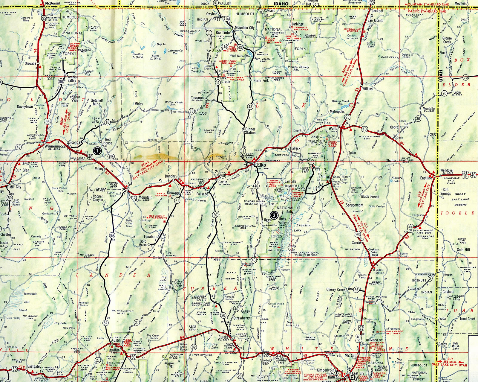
Cities – Verdi, Reno, Sparks, Fernley, Lovelock, Winnemucca, Battle Mountain, Carlin, Elko, Wendover
Junctions –
Utah – 197.51*
Cities – Salt Lake City, Park City, Echo
- Junctions –
Wyoming – 402.76
Cities – Evanston, Lyman, Green River, Rock Springs, Rawlins, Laramie, Cheyenne, Pine Bluffs
- Junctions –
Nebraska – 455.32
Cities – Kimball, Sidney, Ogallala, North Platte, Lexington, Kearney, Grand Island, Seward, York, Lincoln, Omaha
- Junctions –
Iowa – 303.23**
Cities – Council Bluffs, Des Moines, Newton, Iowa City, Davenport
- Junctions –
Illinois – 163.52***
- Cities – Moline, Genesco, Princeton, La Salle, Ottawa, Morris, Joliet, Chicago
- Junctions –
Indiana – 151.56#
Cities – Hammond, Gary, South Bend, Elkhart
Junctions –
Ohio – 237.48##
Cities – Toledo, Elyria, Cleveland, Youngstown
Junctions –
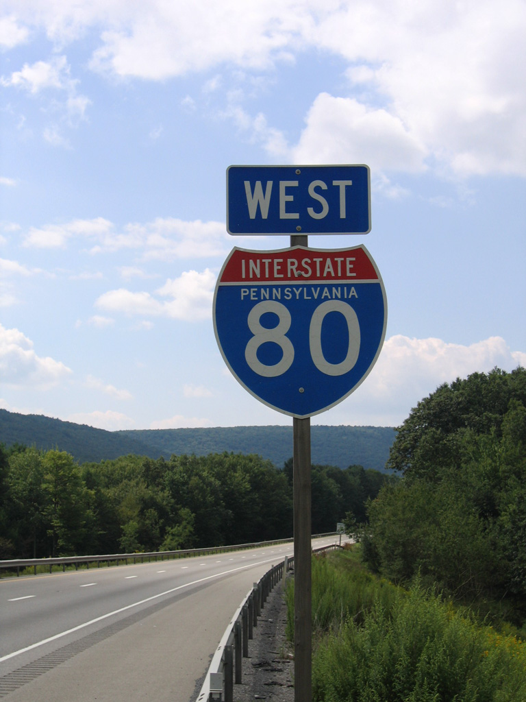
Pennsylvania – 311.12
Cities – Sharon, Mercer, Clarion, Dubois, Milton, Bloomsburg, Stroudsburg
Junctions –

New Jersey – 68.35
Cities – Paterson, Hackensack, Tenneck
Junctions –
Source: December 31, 2021 Interstate Route Log and Finders List
* – 3.31 miles on I-15
** – 3.00 miles on I-29, 14.29 miles on I-35
*** – 2.48 miles on I-94, 5.32 miles on I-294
# – 135.60 miles on I-90, 16.05 miles on I-94
## – 142.80 miles on I-90
I-80 Annual Average Daily Traffic (AADT)
Source: Caltrans, Traffic Operations Program – Traffic and Vehicle Data Systems [2002]
The Annual Traffic Report [2001] (Nevada Department of Transportation)
Utah Department of Transportation – Traffic on Utah’s Highways 2001
2002 Wyoming Vehicle Mile Book (WYDOT)
2002 Traffic Flow Map of the State Highways (State of Nebraska)
INDOT Traffic Count Database System (TCDS) 2018 AADT
ODOT Traffic Data Management System 2018 AADT
Pennsylvania Traffic Volume Map 2017 (PennDOT)
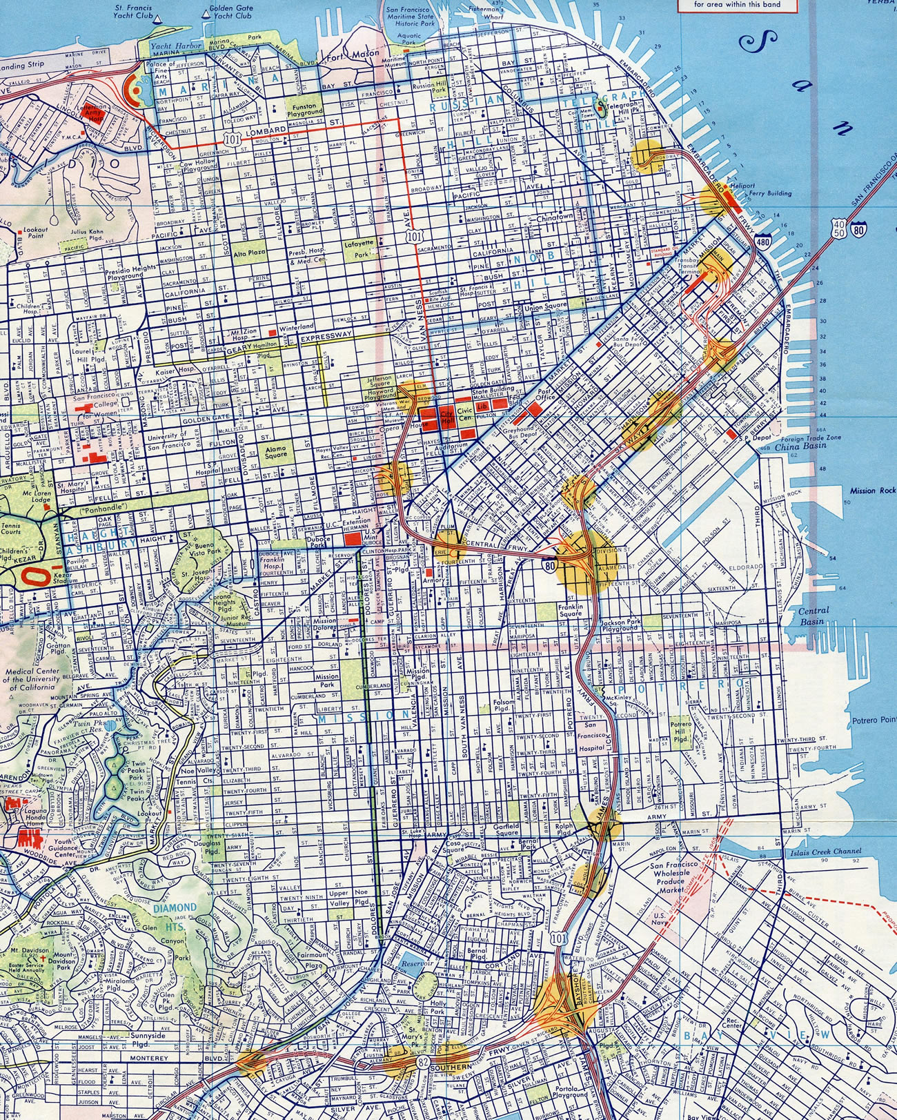
I-80 was dropped from the Central Freeway at the same time Interstate 480 along the Embarcadero Freeway was decommissioned in 1965.
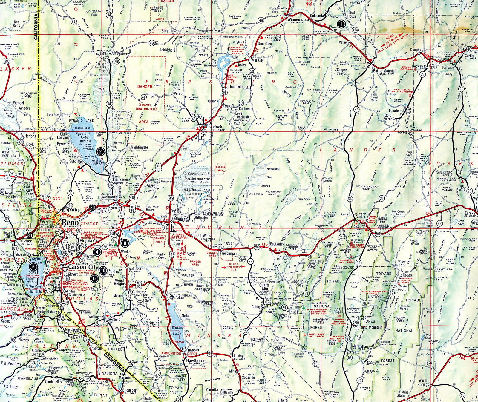
Short stretches of Interstate 80 in northwestern Nevada were complete in 1962: Between Mustang (Exit 23) and Exit 43 west of Fernley and northeast through the Fortymile Desert to Humboldt Sink.
U.S. 40 was upgraded to a freeway by 1962 for Interstate 80 between Golconda and Pumpernickel Valley, including the stretch through Golconda Summit (elevation 5,159 feet).
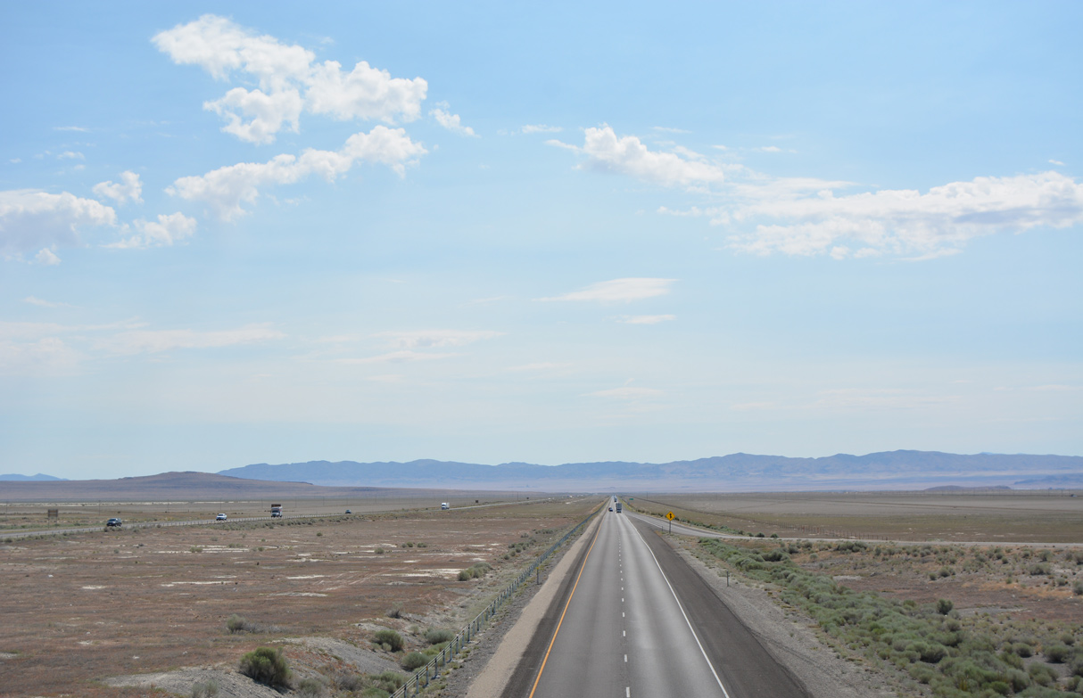
Interstate 80 progresses east from the Great Salt Lake Desert and Knolls, Utah toward Ripple Valley and the distant Cedar Mountains. 07/03/16
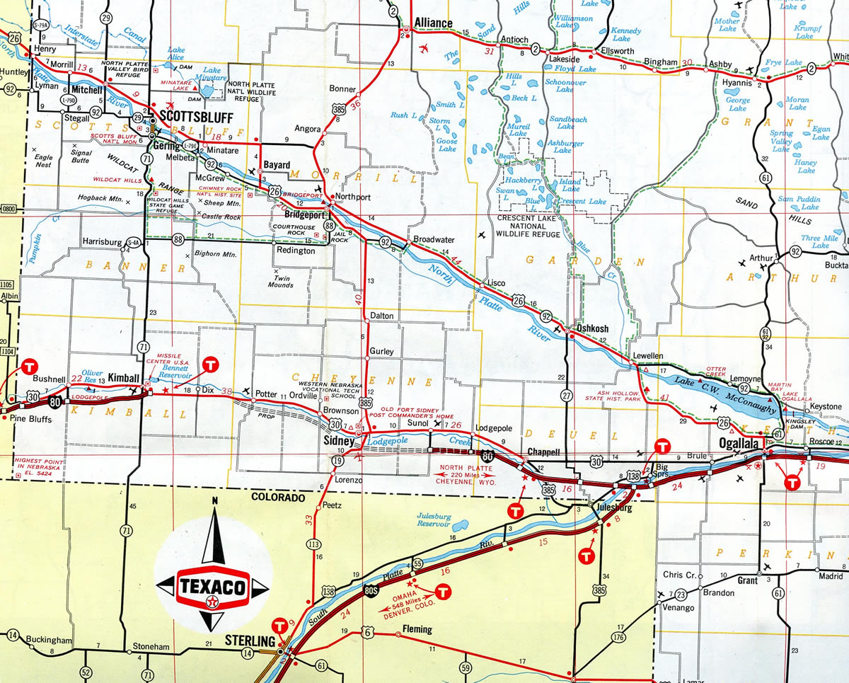
Interstate 80 ended at Kimball, Nebraska from the west and Chappell, Nebraska from the east until 1974, when the stretch by Sidney opened to traffic.
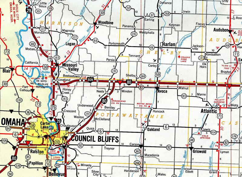
Interstate 80N traveled 17 miles east from I-29 at Loveland to I-80 near Minden, Iowa. The route was incorporated into an extended I-680 from Omaha as approved by AASHTO on November 10, 1973.
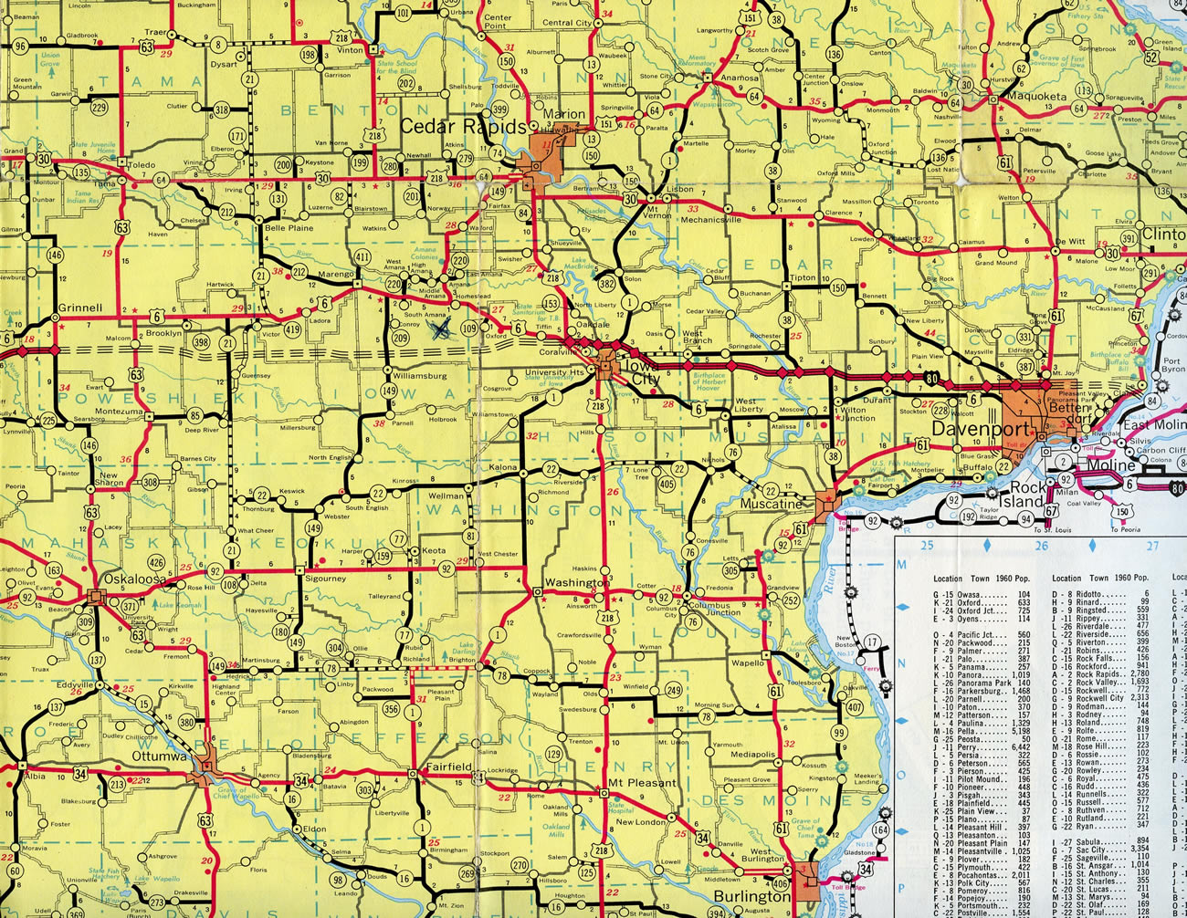
The 57.8-mile stretch of I-80 between Iowa 146 and Coral Ridge Avenue (former U.S. 218) in Iowa City completed the high speed route between Des Moines and the Quad Cities when it opened in October 1964.
The original alignment proposed for Interstate 80 took the route south from the Ohio Turnpike near Norwalk along a parallel alignment to SR 18 to Medina, Akron and the Youngstown vicinity. I-80 later shifted northward to the turnpike, but with a loop using what later became I-480. I-80 between Akron and Youngstown was later incorporated into I-80S and then I-76, while the route west from I-77 was never built.
Iowa
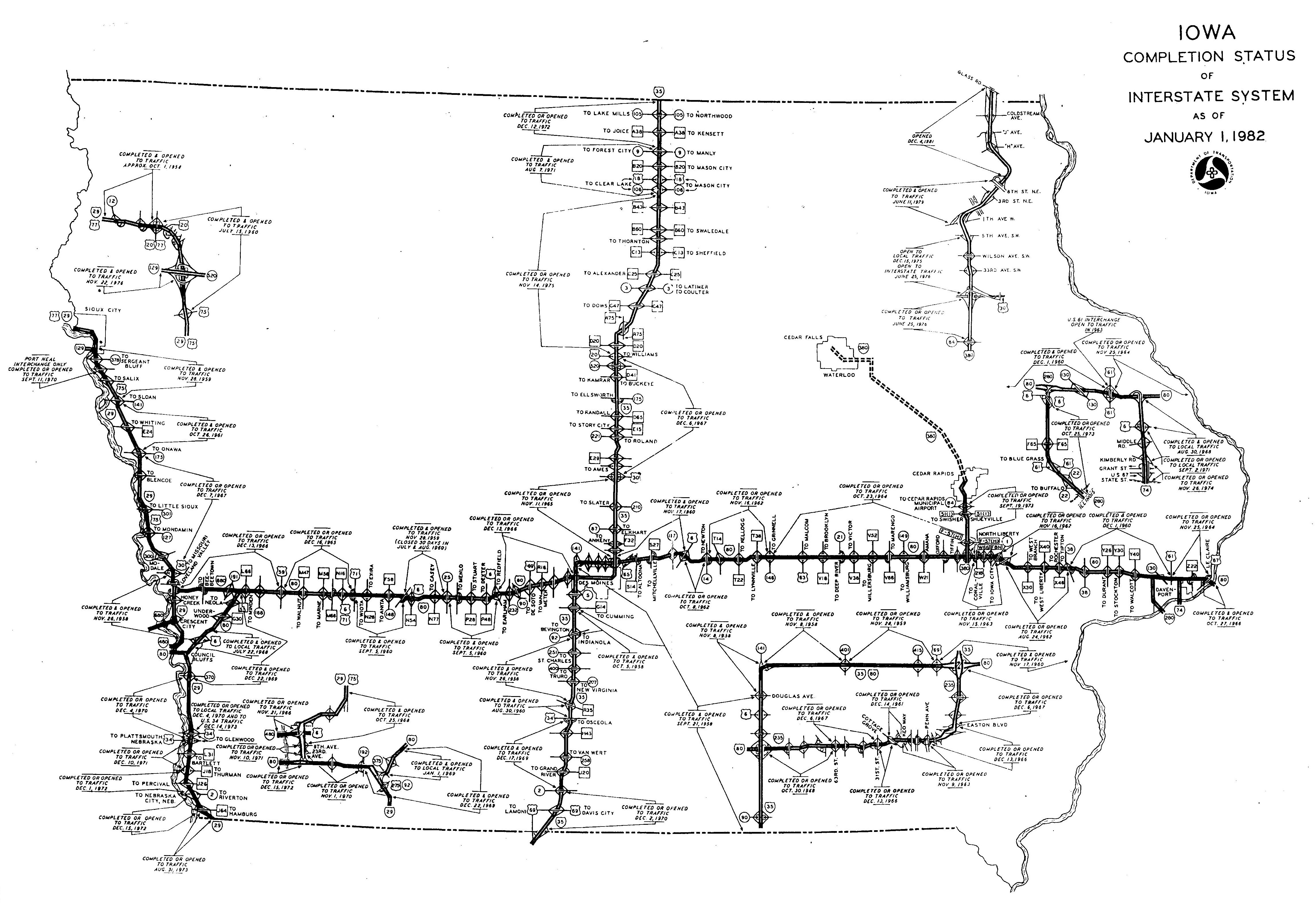
Interstate 80 was constructed in stages across the Hawkeye State. From west to east, the segments opened as follows:2
- Nebraska State Line east to Interstate 29 North: December 15, 1972
- Interstate 29 North to Iowa 192: November 1, 1970
- Iowa 192 to U.S. 6: January 1, 1969
- U.S. 6 to Interstate 880: December 22, 1969
- Interstate 880 to U.S. 59: December 13, 1966
- U.S. 59 to U.S. 71: December 16, 1965
- U.S. 71 to Exit 75, Adair: September 5, 1960
- Exit 75 to Iowa 25: November 28, 1959
- Iowa 25 to U.S. 6 (Adel): September 5, 1960
- U.S. 6 (Adel) to Interstate 235 East: December 13, 1966
- Interstate 235 East to Douglas Avenue: September 21, 1958
- Douglas Avenue to Iowa 28: November 8, 1958
- Iowa 28 to Interstate 235 South: November 28, 1959
- Interstate 235 South to Exit 159: October 8, 1962
- Exit 159 to Iowa 146: November 16, 1962
- Iowa 146 to Old U.S. 218: October 23, 1964
- Old U.S. 218 to Iowa 1: November 15, 1963
- Iowa 1 to Iowa 38 North: August 24, 1962
- Iowa 38 North to U.S. 61: December 1, 1960
- U.S. 61 to U.S. 67: November 25, 1964
- U.S. 67 to Illinois State Line, including the Mississippi River Bridge: October 27, 1966
A proposal arose by 1991 to reroute Interstate 80 over I-280 from northwest Davenport to Colona, Illinois, with Interstate 74 trading places with the existing I-80 around the north and east sides of the Quad Cities. The renumbering was sought to improve safety by eliminating the TOTSO (turn off to stay on) movements at the Big X interchange, the cloverleaf where Interstate 74, I-80 and I-280 meet in Illinois. It never came to pass because Iowa officials did not support the efforts from those in Illinois. See the Interstate 280 Iowa / Illinois guide for more details.
Illinois
Much of Interstate 80 across northern Illinois was constructed in the early 1960s, with the route through south suburban Chicagoland opened to traffic by 1964. The section that I-80 shares with Interstate 294 / Tri-State Tollway was constructed between 1956-1958, with the tollway opening in 1958. The original construction of the 83 mile long section of the Tri-State Tollway, and the other original tollways, was funded by a bond issuance in the amount of $415 million by the state tollway commission created in 1953.11 The Kingery Expressway section of I-80/94 and U.S. 6 is the oldest section of I-80, having opened in 1950.10
The Tri-State Tollway was reconstructed between January 2005 and Fall 2006 from the exchange with IL 394 and I-94 in South Holland northwest to the U.S. 12-20/95th Street interchange in Oak Lawn.3 The project included the installation of an additional through lane on I-80 and I-294. The Cal-Sag Channel Bridge near Alsip was planned for reconstruction, as were the Lincoln Oasis and the Markham Yard Bridge.
A companion project undertaken between January 2005 and July 2007 was the reconstruction of the Kingery Expressway in Illinois and the Borman Expressway in Indiana. Average daily traffic flow on I-80/94 was approximately 160,000 vehicles daily, with a quarter being large trucks.4 For the Kingery Expressway (I-80/94-U.S. 6), improvements included:
- Revision and reconstruction of the I-80, I-94, I-294, and IL 394 interchange
- Expansion to eight through lanes for through traffic on Interstate 80
- Reduction of weaving through reconfigured interchanges
- Installation of sound walls, replacement lighting, and landscaping
Indiana
Within Indiana, the Borman Expressway carries I-80/94 and U.S. 6 through Hammond and Gary. Most of the same improvements considered for the Kingery Expressway were likewise included in the Borman Expressway upgrade. Construction began in 2003. Work ran through Summer 2011 and included an $189 -million upgrade to the interchange with Interstate 65.5 Another proposal is to construct a south Chicago bypass, the Illiana Expressway, that could divert traffic from I-80/94 around the Chicago/Northeast Indiana metro area.
Ohio
Most of Interstate 80 across the Buckeye State was constructed as part of the Ohio Turnpike, the origins of which predate the establishment of the Interstate Highway System in 1956. The Ohio state legislature created the Ohio Turnpike Commission in 1949, which was the first step in designing and constructing the cross state highway. 38 months of construction began on October 27, 1952, and the toll road was completed on October 1, 1955.6
159 miles of the Ohio Turnpike were expanded to six overall lanes in a nearly two decade long project. First announced by the Ohio Turnpike Commission in April 1995, widening of the toll road was ultimately paid for by a toll increase of more than 80%. The added lanes run from U.S. 20 in Toledo east to the I-80 junction with I-76 outside Youngstown.
Work was slow with three sections entailing 59.3 miles completed by 1997. The initial 2000 completion date announced by the Turnpike Commission was moved back to 2004, then 2008. By 2004, expansion was completed except for three segments: I-280 to I-75, I-75 to U.S. 20 (Reynolds Road) and a four mile stretch east of the Cuyahoga River. The I-280 to I-75 stretch in Toledo was finished in 2007, however the economic turn down of the late 2000s led the Turnpike Commission to defer funding from the remaining two sections to instead replace its toll collection system. E-ZPass was implemented along the turnpike in 2009 upon completion of the $50 million upgrade.
A $33.5 million contract added a third lane in each direction of I-80/90 between I-75 and U.S. 20 started in early 2013. This added to the nearly $750 million total expenditure for the overall expansion project. The final 4.6 miles of the project were finished by November 2014.19
Pennsylvania
Just prior to Exit 111 with PA 153 south of Penfield, westbound Interstate 80 crests at the highest point east of the Mississippi River. Located within Moshannon State Forest along Pennsylvania’s section of the Appalachian Mountains, this location reaches 2,250 feet above sea level. Advancing west, I-80 leaves the Chesapeake Bay watershed and enters the Allegheny River watershed.
The Keystone Shortway, which carries Interstate 80 across Pennsylvania, was completed and fully opened to traffic on September 17, 1963. The last segment to be opened to traffic was the section from Stroudsburg to Scotrun.7
New Jersey
All segments of Interstate 80 were opened to traffic within the Garden State by November 1973.24
 Photo Guides
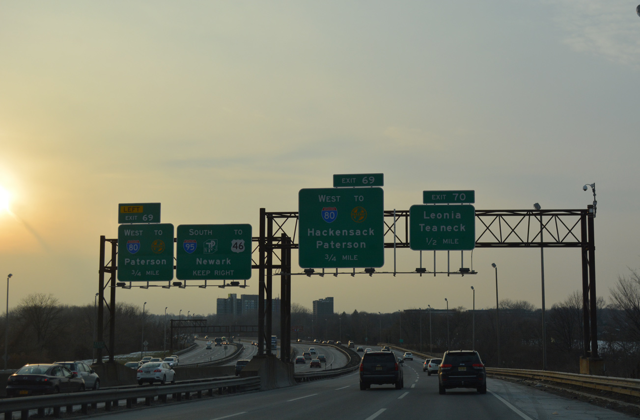
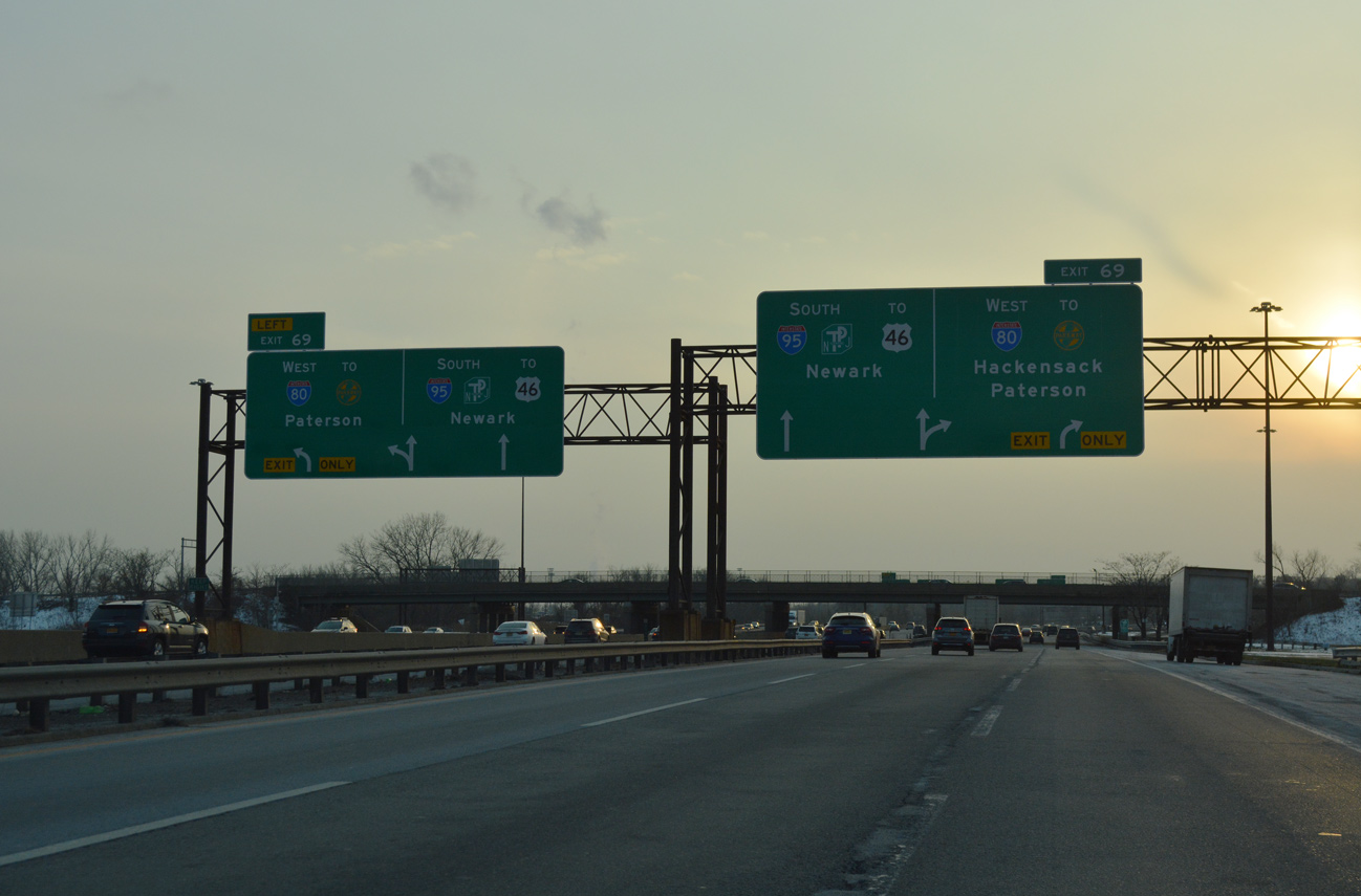
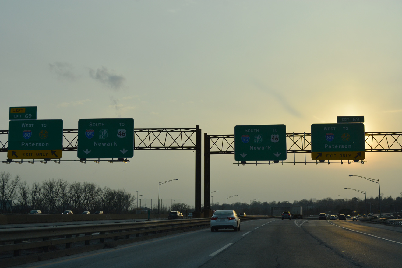
East End  – Ridgefield Park, New Jersey
![]() East at
East at ![]()
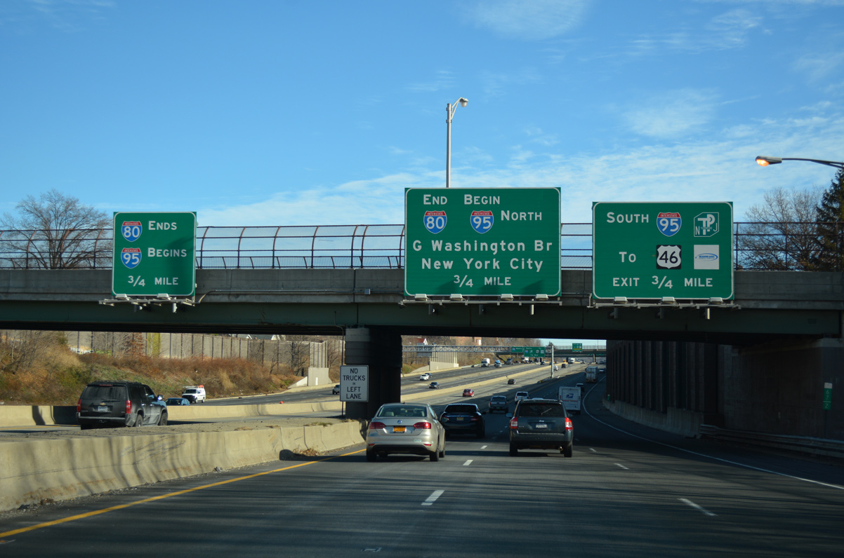
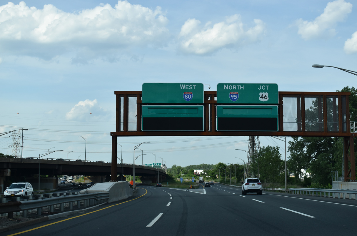
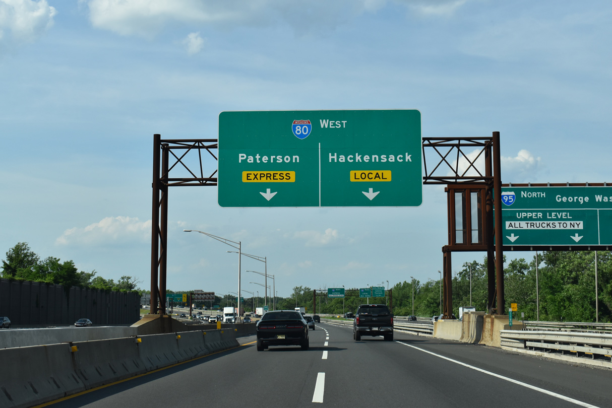
Several miles ahead of the Interstate 80 terminus, the eastbound freeway splits into Express and Local lanes. The I-80 Express lanes have no exits from the partition to I-95 while the Local lanes provide access to Hackensack and other nearby communities. The dual freeway configuration extends east along Interstate 95 to the George Washington Bridge Upper and Lower Level separation at Fort Lee. 12/19/16
Interstate 80 travels below grade across the Bogota borough and Ridgefield Park village line. The route ends one half mile ahead at an unnumbered directional T interchange. 12/19/16
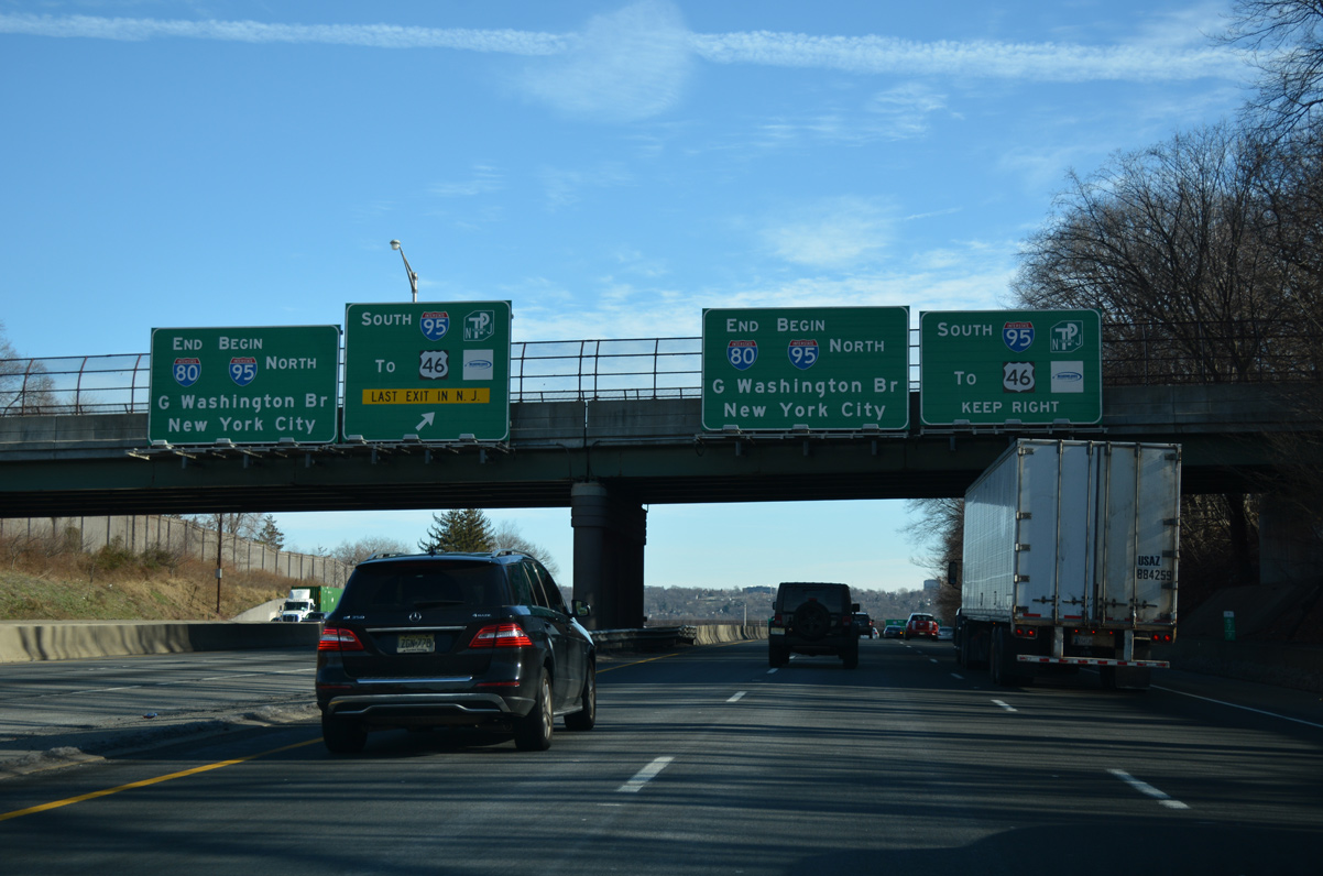
End signs for Interstate 80 appear above both the Local and Express Lanes as the freeway passes below Park Avenue along the Teaneck township and Ridgefield Park line. NJDOT typically posts end / begin signage at transitions of one freeway to another. Other examples are posted for I-676 south, Route 3 east and I-195 west. 12/19/16
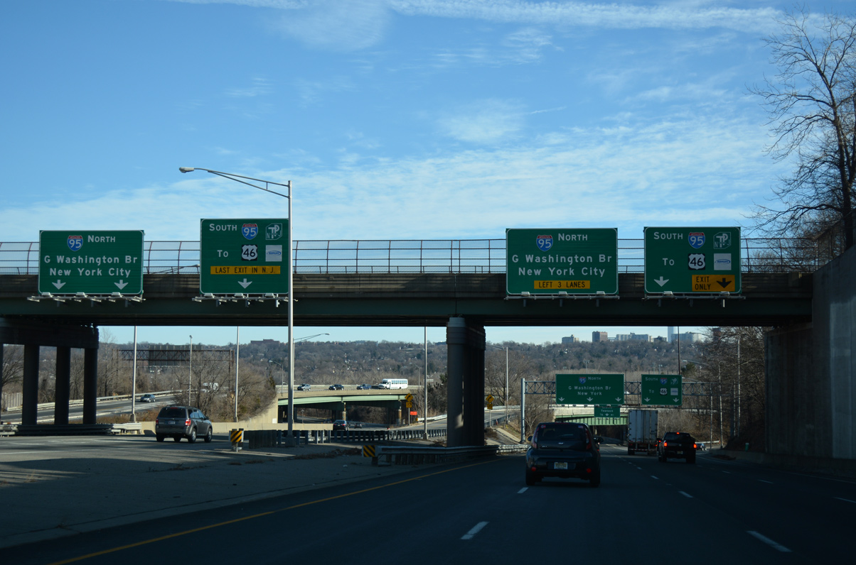
Ramps depart from both the Local and Express lanes of I-80 at the Teaneck Road overpass for I-95 and the New Jersey Turnpike south to U.S. 46 at Ridgefield Park, Newark and Trenton. A final off-ramp (Exit 73 to Route 67) departs from the I-80 Express lanes before the roadway defaults onto the George Washington Bridge Upper Level. 12/19/16
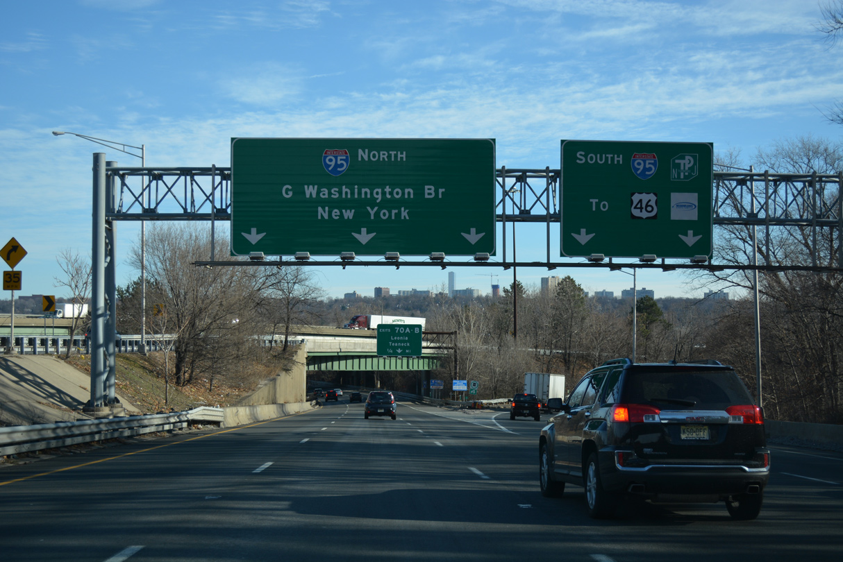
Interstate 80 concludes a 2,900 mile plus journey across 11 states. The Local Lanes advance east to Fort Lee and the George Washington Bridge. NY 9A (Henry Hudson Parkway) lies five miles ahead at the first exit in Manhattan. 12/19/16
![]()
![]() East Spur – North at
East Spur – North at ![]()
Beyond the Lincoln Tunnel interchange and near Bellmans Creek, the NJ Turnpike East Spur advances to the merge with the West Spur, where a dual freeway configuration commences north. The forthcoming inside lanes lead directly to I-80 while the outside lanes continue to Englewood and the George Washington Bridge approach. 05/31/22
The East and West Spurs of the NJ Turnpike combine just north of the Vince Lombardi Service Area. A wye interchange provides two lanes from the East Spur for I-80 west to Hackensack and Patterson. 05/31/22
New signs were installed in 2022 along the I-95 East Spur at I-80. The I-95 mainline follows the outer roadway to a cloverleaf interchange with U.S. 46 at Ridgefield Park. 05/31/22
![]()
![]() West Spur – North at
West Spur – North at ![]()
The New Jersey Turnpike splits into East and West Spurs around Secaucus. The separation disperses traffic to I-280 west through Newark, Route 495 east to the Lincoln Tunnel and Route 3 to the Meadowlands. The spurs recombine at Overpeck Creek, 1.5 miles ahead of the Interstate 80 east end. 12/19/16
The West Spur (unsigned I-95W) ends with a slip ramp taking motorists onto the inner roadway bound for Interstate 80 west and two lanes merging with the outer roadway ahead of U.S. 46, Challenger Road, and the eastern turn of I-95 to the George Washington Bridge. 12/19/16
![]() North at
North at ![]()
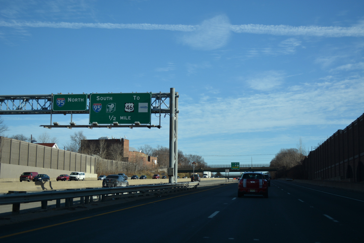
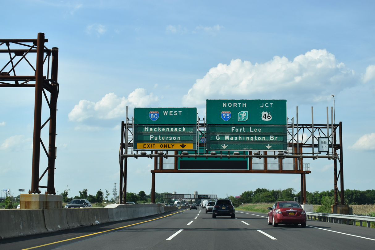
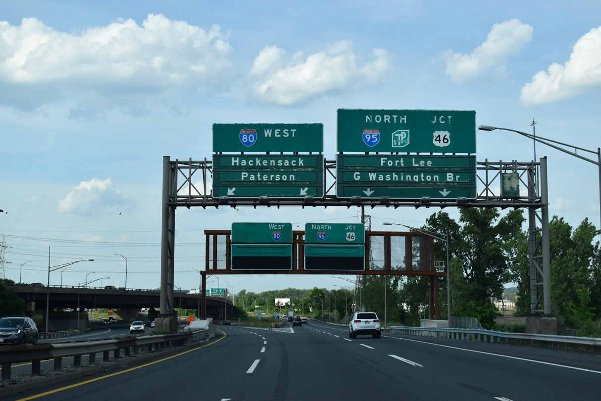
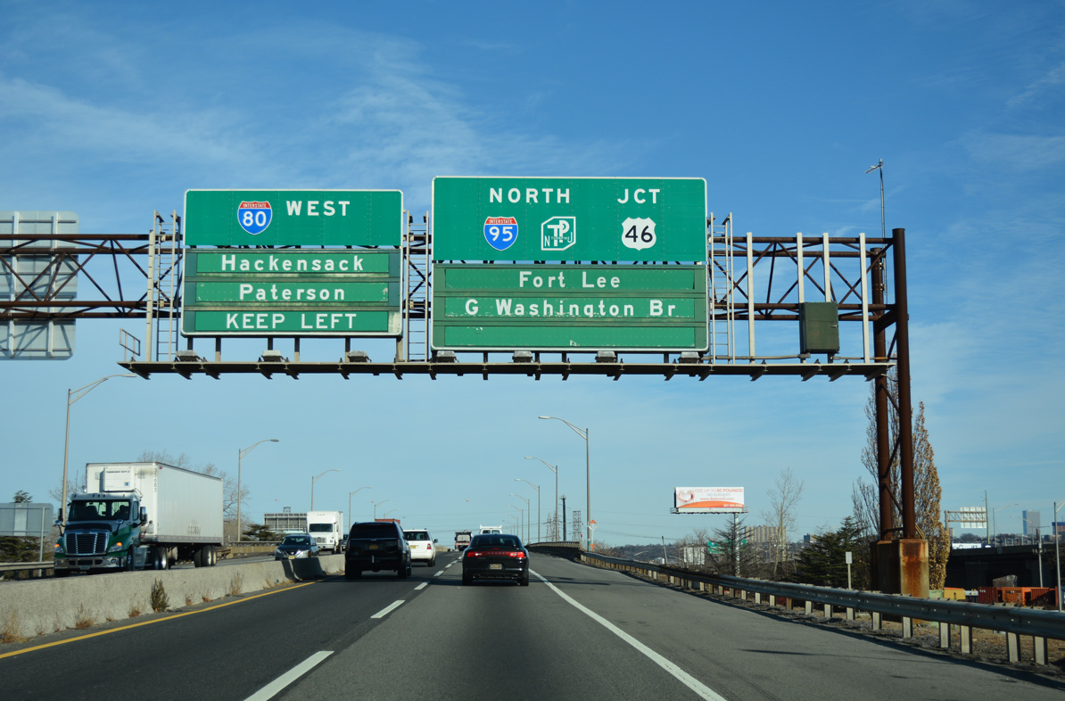
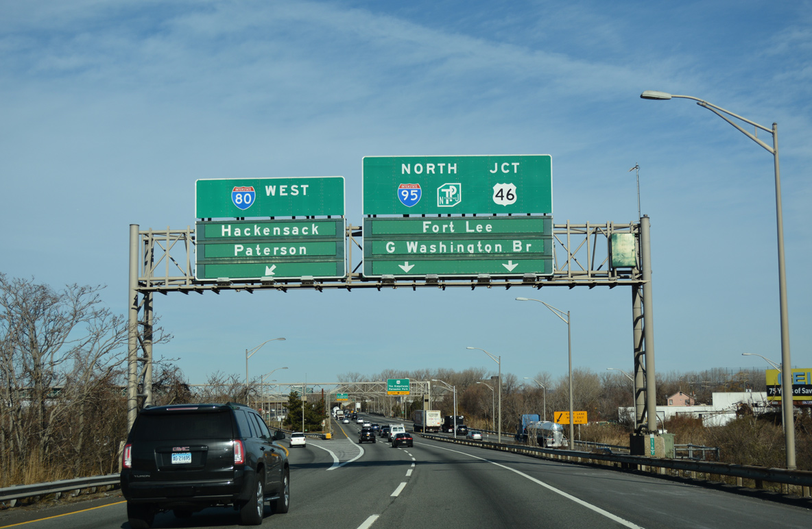
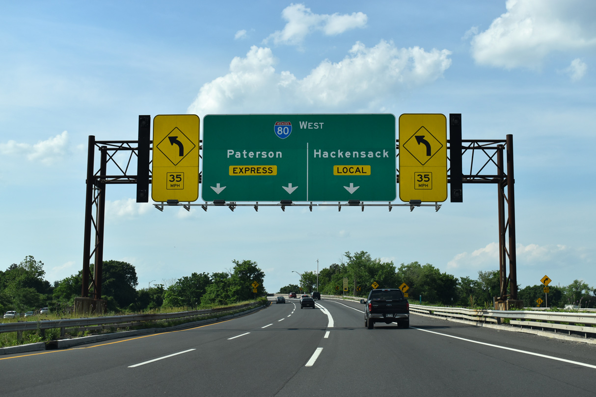
The inner roadway of I-95 leading north from the NJ Turnpike defaults travelers onto Interstate 80 west. I-80 separates into a Local / Express configuration to Paterson. 05/31/22
The Local / Express configuration of I-80 extends east onto I-95 toward the Upper and Lower Level split of the George Washington Bridge. The Local lanes of I-80 west provide access to all off-ramps while the Express lanes advance uninterrupted to Route 17 (Exit 63) at Lodi. 05/31/22
A three lane flyover branches west to slip ramps with I-80 Local to Hackensack and I-80 Express to Paterson and Netcong. 05/31/22
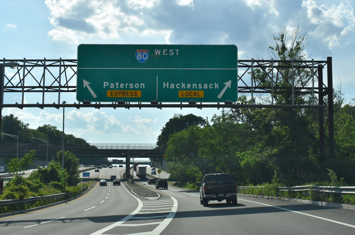
West from the directional-T interchange with I-95, Interstate 80 passes through Bogota and Ridgefield Park to Hackensack. 05/31/22
![]() South at
South at ![]()
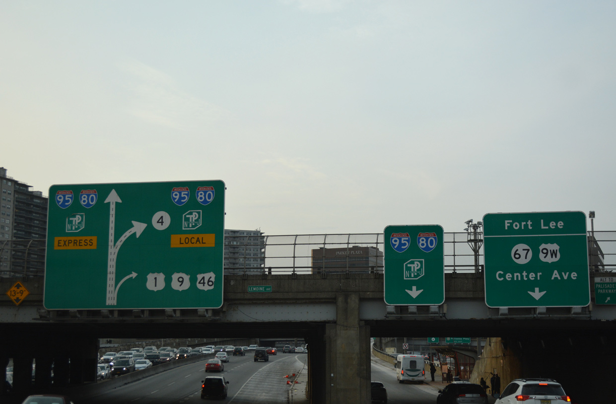
Passing below the Route 67 (Lemoine Avenue) overpass, the Upper Level of the George Washington Bridge transitions into the Express Lanes of I-95 south / I-80 west. 12/17/17
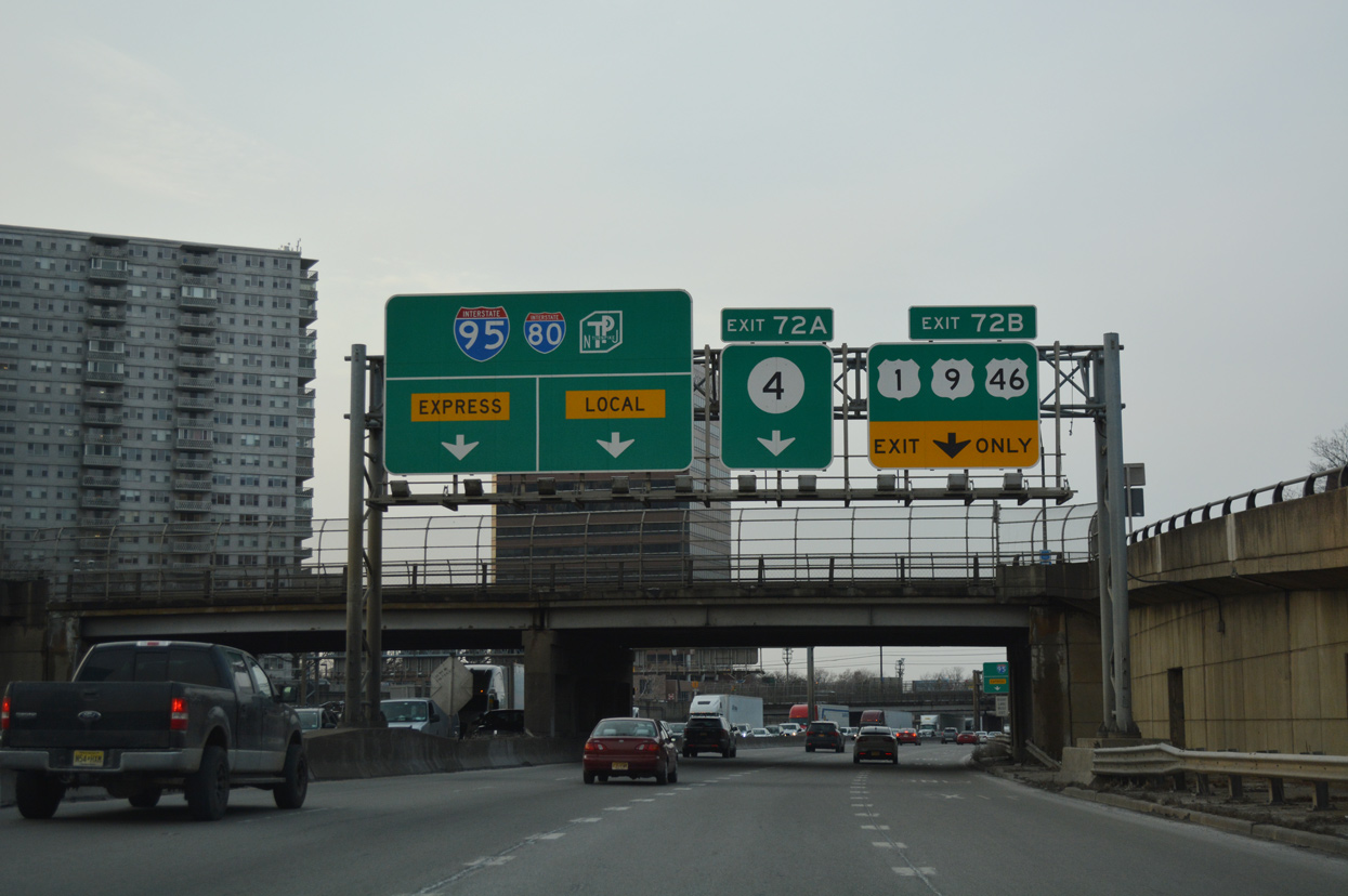
Succeeding ramps depart for U.S. 1-9 south / U.S. 46 (Bergen Boulevard) west (Exit 72B) and the I-95 south / I-80 west Local lanes at Route 4 (Exit 72). 12/17/17

U.S. 1/9/46 separate from I-95 to Palisades Park. U.S. 46 parallels Interstate 80 west to Ridgefield Park and Teterboro. 12/17/17
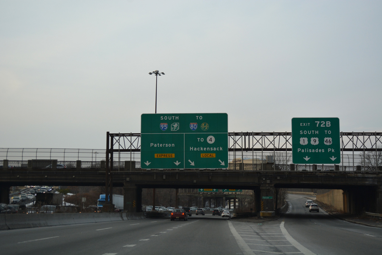
The Lower Level of the George Washington Bridge forms the Local Lanes for Interstate 95 leading west from Fort Lee to Leonia. Both the Express and Local Lanes eventually connect with I-80 west toward Paterson. 12/17/17
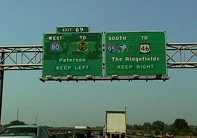
The c/d roadway for Route 4 (Exit 72) links the I-95 Express Lanes with the Local Lanes two miles ahead of Interstate 80 (Exit 69). 12/17/17
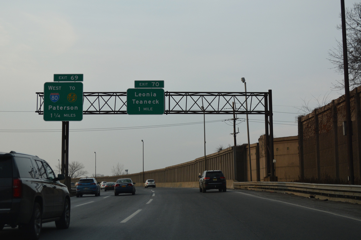
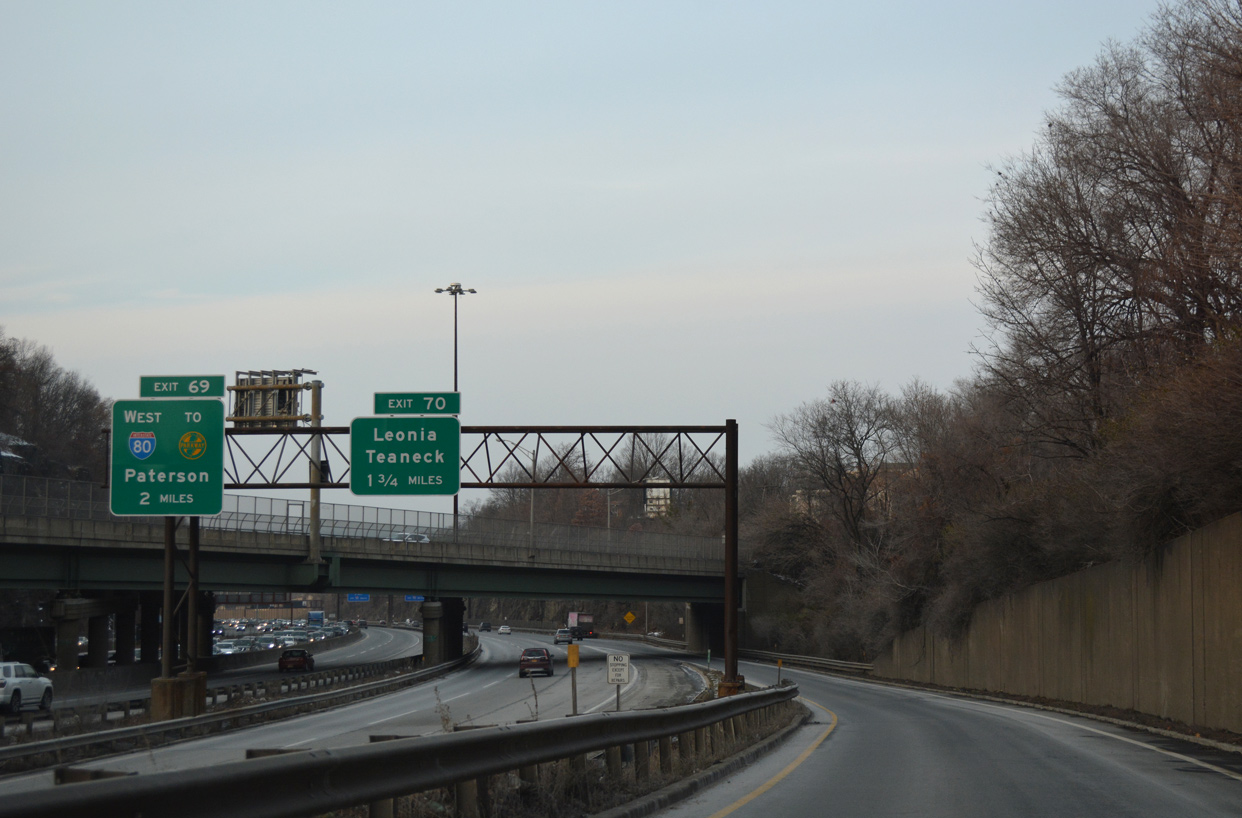
Interstate 95 arcs 1.25 miles west as a dual freeway to the westbound beginning of Interstate 80 in Teaneck township. The Local Lanes meet Degraw Avenue prior to I-80. 12/17/17
Nearing the crossing of Overpeck Creek along the Local Lanes of Interstate 95 south. The Local / Express Lanes extend west along I-80 through Hackensack. The continuation of both roadways are signed as Exit 69, which coincidentally is one mile higher than the I-80 mileage to the Pennsylvania state line. 12/17/17
Advancing west from the cloverleaf interchange with Degraw Avenue, simultaneous exit ramps depart from both roadways to I-95 and the New Jersey Turnpike south to Newark. Tolling commences along I-95 beyond the adjacent interchange with U.S. 46 (Winant Avenue) at Ridgefield Park. 12/17/17
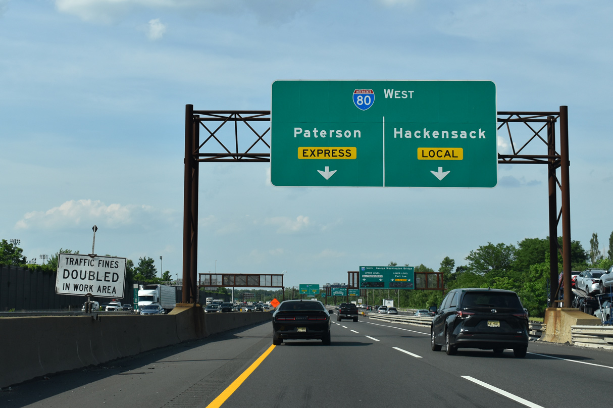
Two lanes proceed west from southbound I-95 onto Interstate 80. I-80 winds through urban areas of Hackensack and Paterson to suburban areas of Parsippany-Troy Hills, Dover and Netcong. 12/17/17
![]() West
West
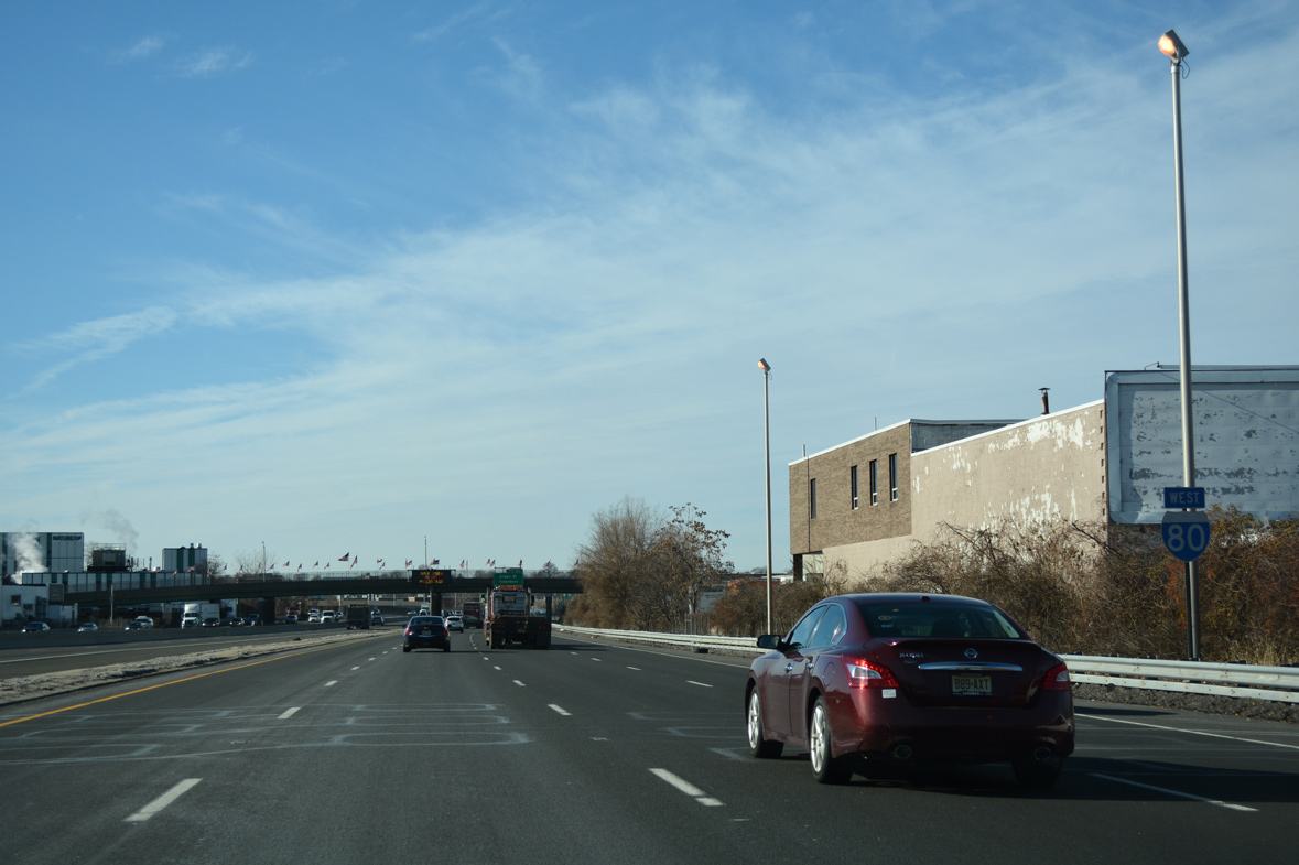
The first confirming marker for Interstate 80 west appears after the wye interchange (Exit 66) to Kennedy and Hudson Streets in Hackensack. 12/19/16
East End Throwback
Traffic emerges from the George Washington Bridge Lower Level to circumvent the eastbound toll plaza ahead of the Route 67 (Lemione Avenue) overpass. A button copy overhead directed motorists to remain along the I-95 mainline as it progressed west to I-80. This sign was replaced by late 2000 with a diagrammatic sign. Photo taken by Jim K. Georges (07/99).
As the Upper Level roadway transitioned into the Express Lanes, a set of button copy signs directed motorists onto the Local Lanes as Route 4. These trapezoidal type signs used to be found along I-95 between Fort Lee and the Cross-Bronx Expressway in New York. Photo taken by Jim K. Georges (07/99).
Button copy sign formerly posted at the Fletcher Avenue overpass for the impending ramp to both Route 4 north and the I-95 Local Lanes. Photo taken by Jim K. Georges (07/99).
The Local and Express Lanes of I-95 progressed south to Teaneck and the split with Interstate 80 west at Exit 69. Photo taken by Jim K. Georges (07/98).
Another set of button copy signs preceded the directional T interchange (Exit 69) with I-80 on I-95 Express south. I-80 connects with the Garden State Parkway at Exit 62. Photo taken by Jim K. Georges (07/99).


All guide signs along Interstate 95 leading west to the New Jersey Turnpike and I-80 were replaced in 2017 to be MUTCD complaint. 12/19/16
West End  San Francisco Oakland Bay Bridge / Embarcadero – San Francisco, California
![]() West
West
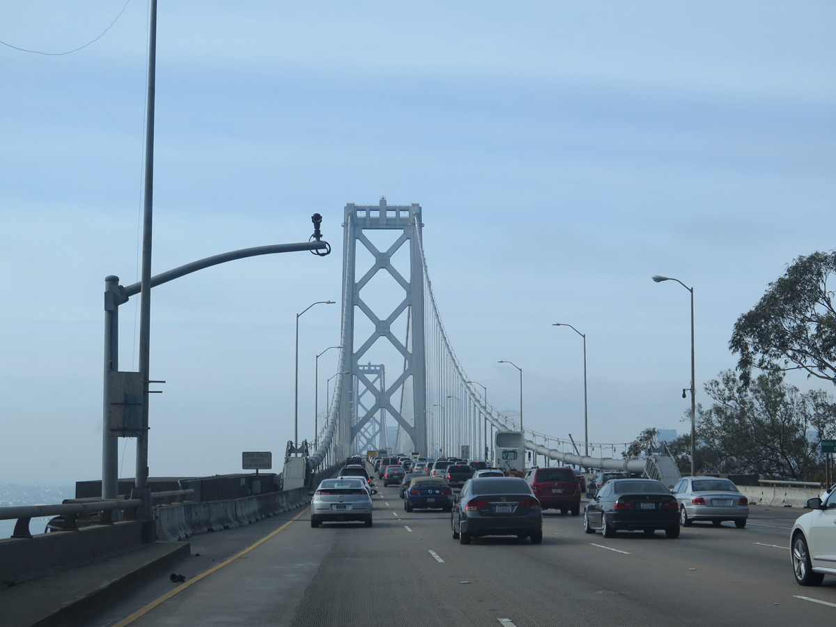
Interstate 80 passes through the Yerba Buena Island tunnel and emerges on the suspension bridge portion of the San Francisco-Oakland Bay Bridge. Bridge construction began on July 9, 1933, and it opened to traffic on November 12, 1936, as part of U.S. 40-50. I-80 replaced U.S. 40-50 legislatively in 1964, and signs were removed in the ensuing decade. Photo taken 03/09/15.
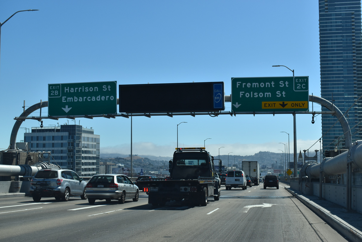
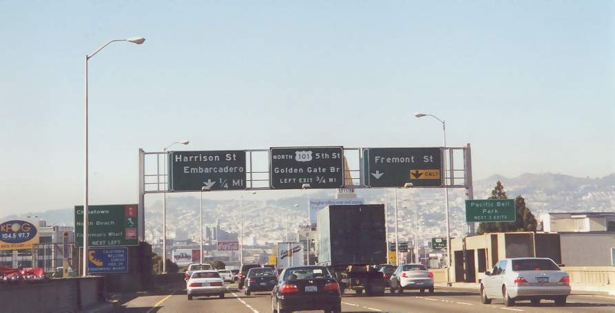
The San Francisco Oakland Bay Bridge reaches back to back ramps for Fremont Street (Exit 2C) and Harrison Street (Exit 2B) to Chinatown, the Embarcadero and Fisherman’s Wharf. The Fremont Street exit also connects to Interstate 280 via surface streets. 07/11/18

Exits 2 C/2 B lower from I-80 as the freeway transitions onto a viaduct ahead of the directional T interchange with U.S. 101. The Folsom-Fremont exit is the site of the former Embarcadero Freeway (SR 480) interchange. The freeway spur along SR 480 was dismantled after sustaining major damage during the 1989 Loma Prieta Earthquake. 07/06/22
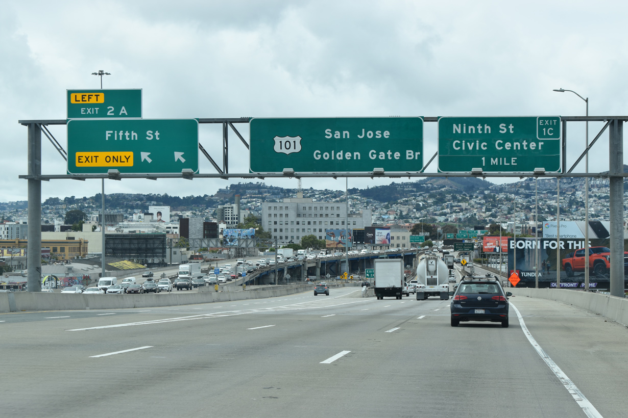
Left Exit 2 A follows from Interstate 80 west to Fifth Street. The Fifth Street exit is the original end of the western approach to the Bay Bridge; it was also the route U.S. 40-50 historically took off the bridge to their shared endpoint at U.S. 101. 07/06/22
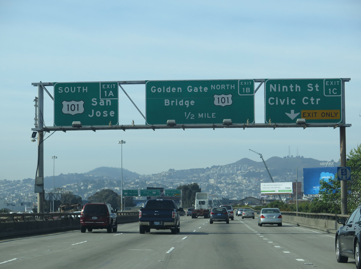
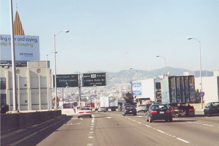
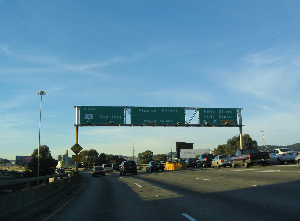
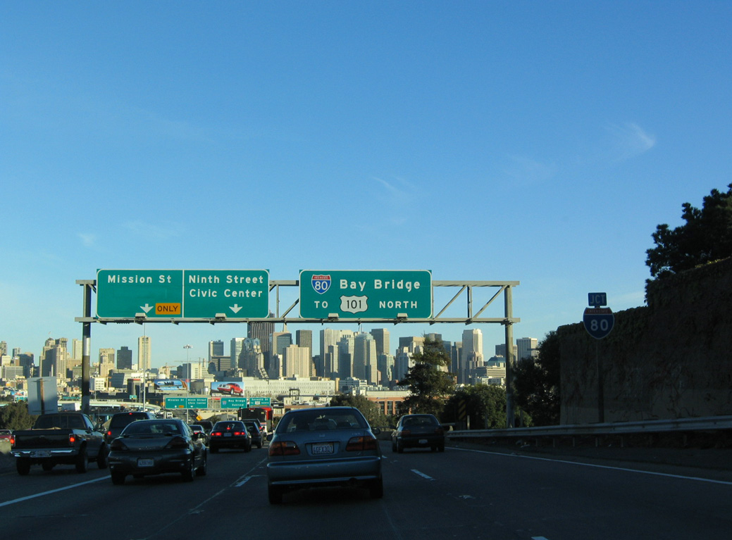
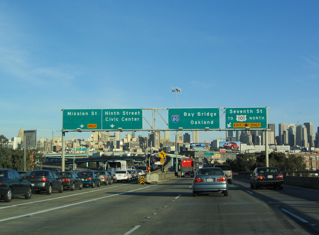
Remaining elevated along James Lick Skyway, a viaduct with some sections that predate the Interstate Highway System, I-80 west advances to Exit 1C for Eighth and Harrison Streets. Adjacent Ninth Street leads north to the Civic Center. 03/09/15
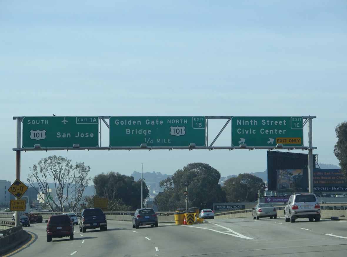
Exit 1C parts ways with I-80 (James Lick Skyway) as the freeway turns south to end at U.S. 101. U.S. 101 follows city streets between the Central Freeway spur and the Golden Gate Bridge approach. The route is not advised for truck traffic due to limited sight distance and turning radius. Historically, U.S. 101 was planned for a freeway north to the Golden Gate Bridge. 03/09/15
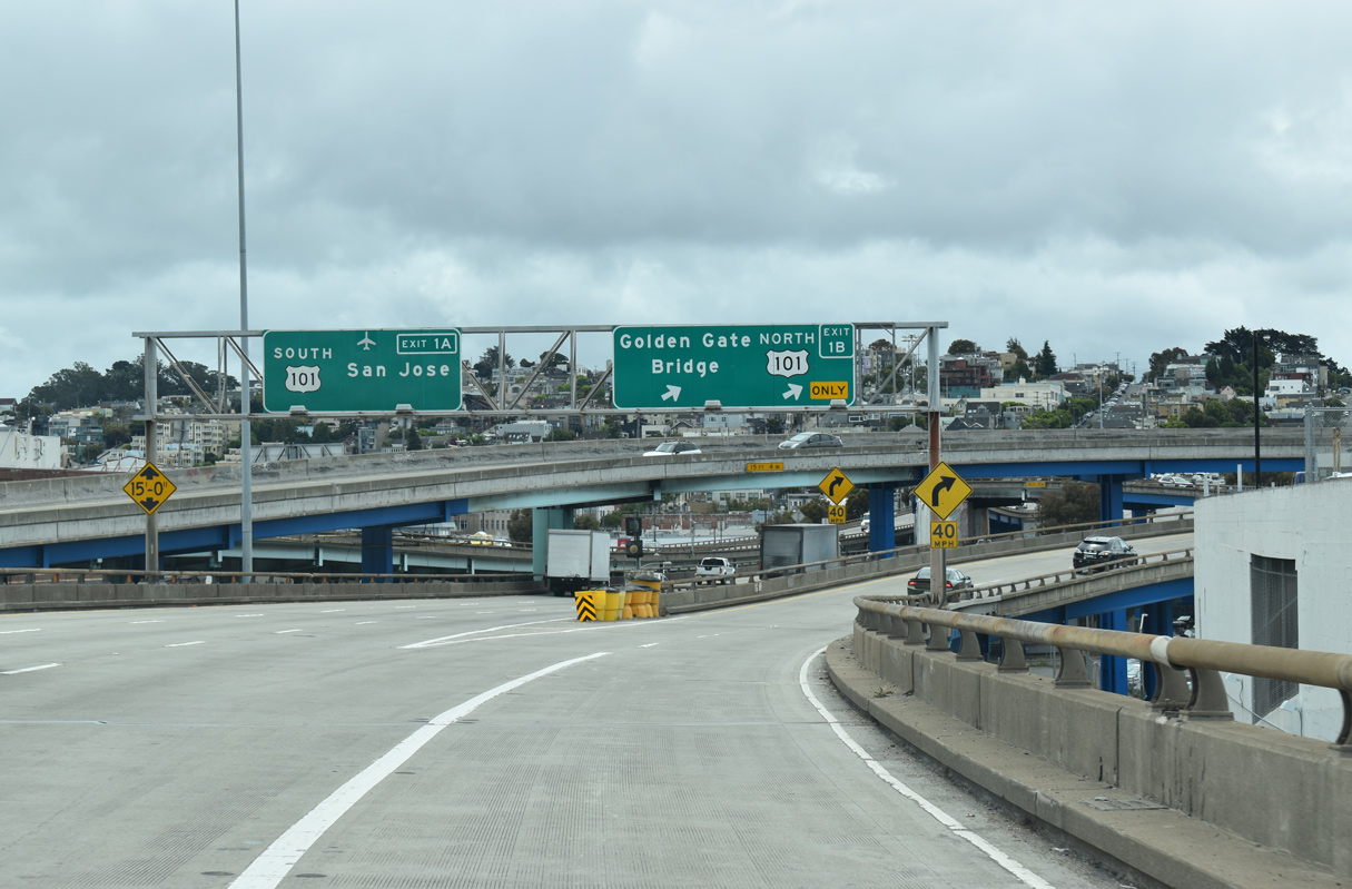
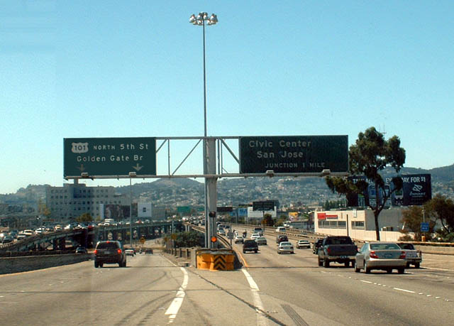
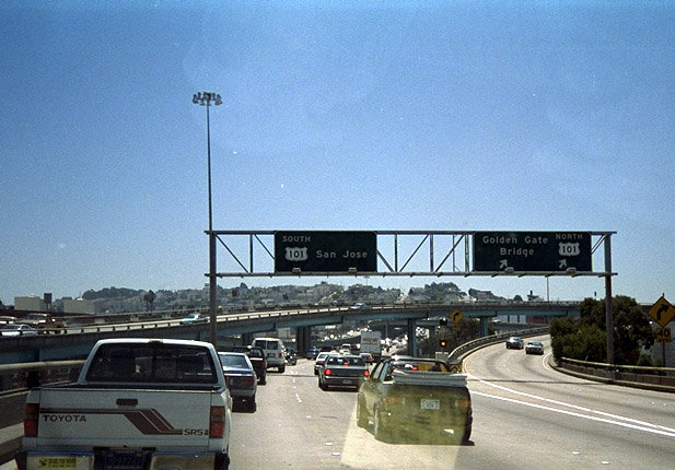
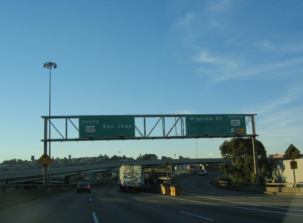
I-80 ends as traffic partitions at Exits 1 B/A. U.S. 101 north takes the Central Freeway west to Mission Street north to join Van Ness Avenue. The route formerly extended west to Market Street.
U.S. 101 south overtakes the freeway leading to South San Francisco, San Mateo and San Jose. 07/06/22
![]() North at
North at ![]()
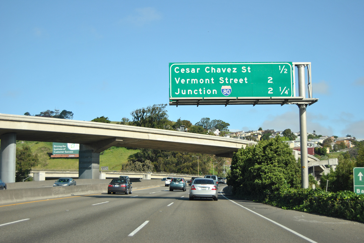
U.S. 101 winds northward between the Bernal Heights and Bayview neighborhoods beyond the exchange with I-280 to meet transcontinental Interstate 80 in 2.25 miles. 03/27/16
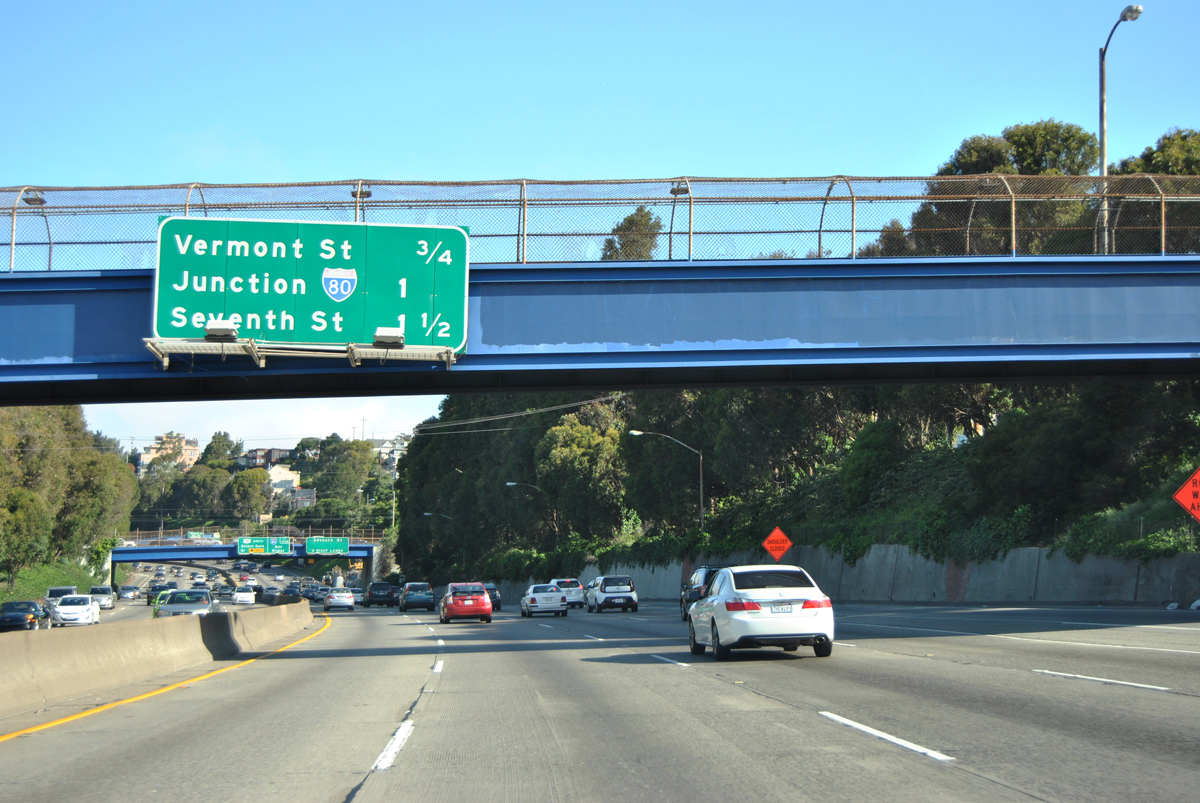
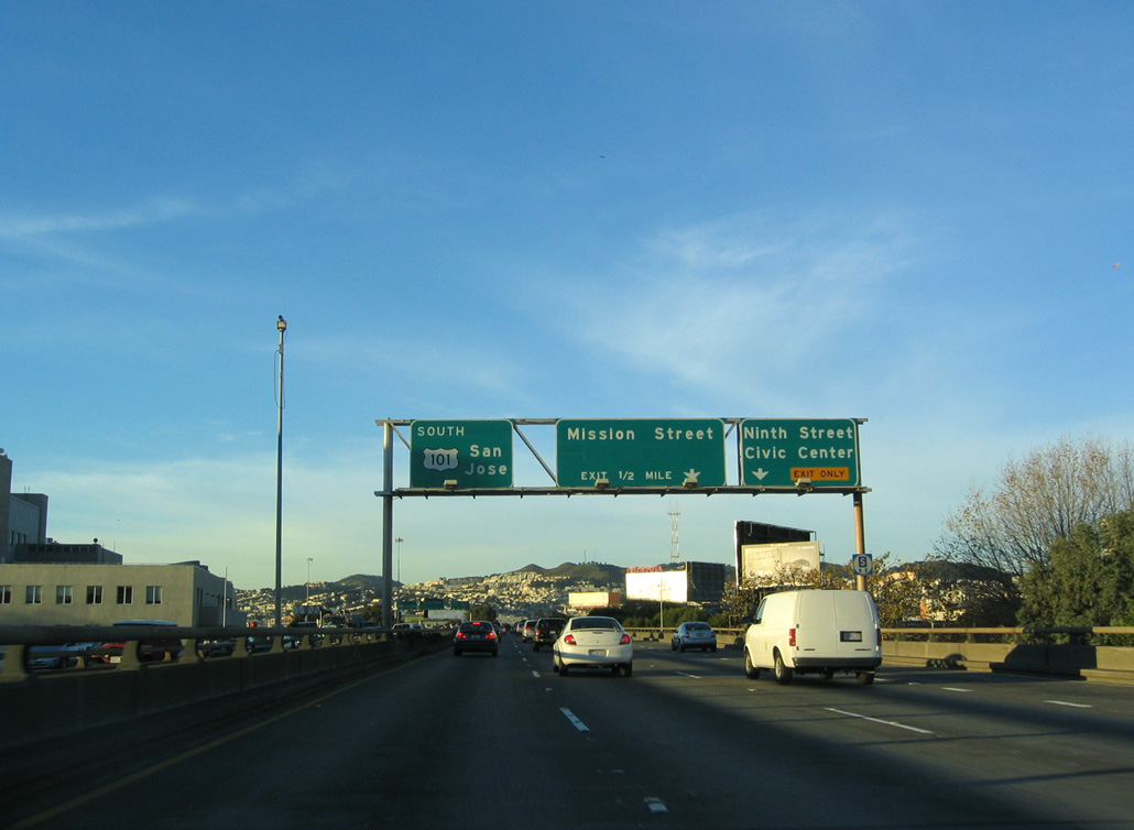
A second interchange sequence sign with I-80 appears after the Cesar Chavez Street interchange, one mile south of the split from U.S. 101. U.S. 101 runs between the Inner Mission and Potrero Hill communities to the ensuing Vermont Street off-ramp (Exit 433A). 03/27/16
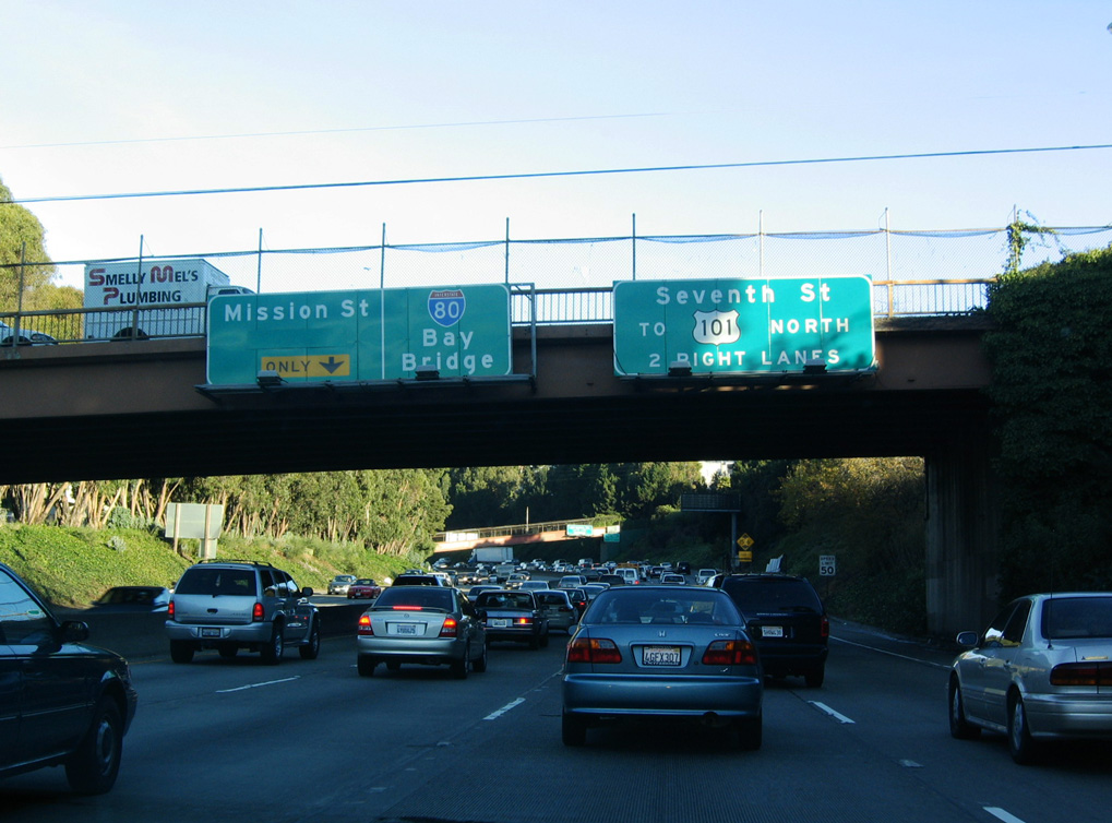
Passing under 23rd Street along U.S. 101 north. U.S. 101 branches westward at forthcoming I-80 for the Central Freeway spur west to Van Ness Avenue. Seventh Street (Exit 1) is the first off-ramp from Interstate 80 east. 03/27/16
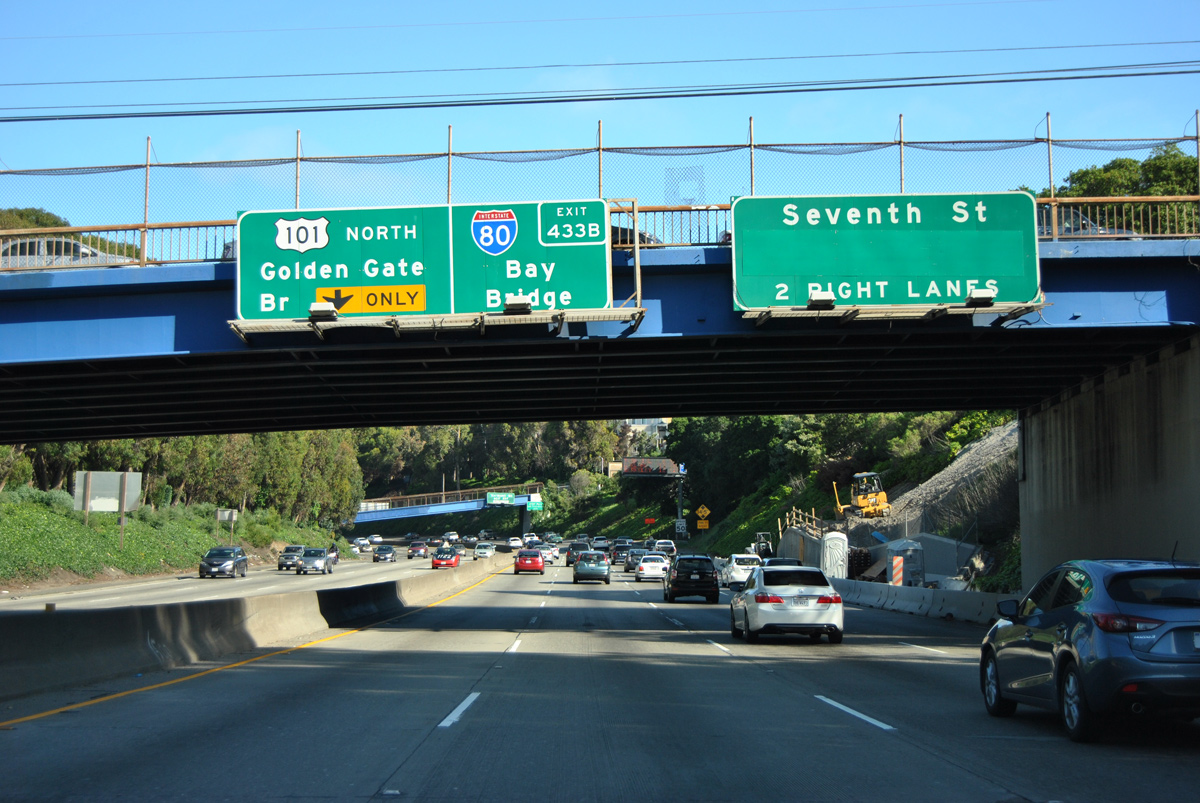
A junction I-80 shield assembly, normally reserved for a side street, appears on the U.S. 101 freeway mainline. U.S. 101 turns onto the Central Freeway west to Van Ness Avenue for the continuation to the Golden Gate Bridge. The number two lane also comprises a left exit for Ninth Street and the Civic Center. 03/27/16
Beyond Interstate 80 and the Central Freeway, U.S. 101 follows Van Ness Avenue, a major route through the city, to Lombard Street and the Golden Gate Bridge. Van Ness Avenue is six lanes wide, but nearly every major intersection is controlled by traffic signals. Trucks are not advised on the route. 03/27/16

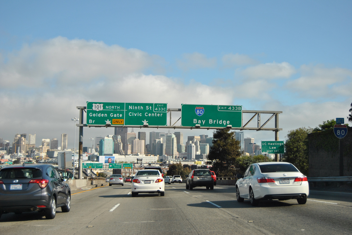
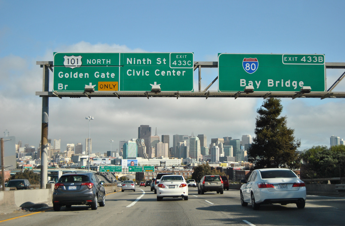
The skyline of the City by the Bay spreads across the horizon as Interstate 80 east begins via Exit 433B. The Central Freeway takes U.S. 101 west toward the Octavia Boulevard exit. This section of U.S. 101 was formerly planned as part of I-80 from a proposed to extend the freeway west along the Fell Street/Oak Street corridor to Golden Gate Park and SR 1. 03/27/16
![]() South at
South at ![]()
A loop ramp brings U.S. 101 south onto the Central Freeway from Van Ness Avenue. The elevated roadway proceeds east from there directly to Interstate 80. Overtaking the James Lick Freeway south, U.S. 101 forms an important corridor for the West Bay communities of San Bruno, San Mateo, Menlo Park and Palo Alto. 07/06/07
A left side ramp takes motorists from U.S. 101 (Central Freeway) south onto Interstate 80 (James Lick Freeway) east. I-80 travels through South of Market and Yerba Buena to the San Francisco-Oakland Bay Bridge into Alameda County. The city of Oakland is an eight mile drive to the east across the Bay Bridge. 07/06/07
![]() East
East
Exit 1 quickly departs I-80 east for Seventh Street after the split with U.S. 101 (Central Freeway) north. The final exit on the San Francisco Peninsula follows for Fourth Street and the Embarcadero. This was the former end of SR 480, which in the mid-1960s was designated I-480. SR 480 (Embarcadero Freeway) partially collapsed in the 1989 Loma Prieta Earthquake. It was demolished by 1993. The unconstructed connection with I-280, which currently ends near AT&T Park, would have met I-80 near that same point. Photo taken 03/27/16
The first shield for Interstate 80 east stands between the travel lanes ahead of Exit 1. 03/27/16
West End Throwback
![]() West at
West at ![]()
Upon leaving the suspension portion of the San Francisco-Oakland Bay Bridge, this set of button copy signs directed motorists to Fremont Street and Folsom Street to the Embarcadero. This sign bridge was replaced in 2006-2007. 10/15/00
Prior to the demolition of the original western approach to the Bay Bridge, a left exit lowered from the Skyway to the Embarcadero and Harrison Street. Exit 2B (Harrison Street) was located just a few hundred feet west of Exit 2C to Fremont Street. 10/15/00
The 5th Street exit from I-80 (James Lick Skyway) west was previously signed as a connection to U.S. 101 north. Back when U.S. 40 and U.S. 50 entered the city via the Bay Bridge, the pair took this ramp to meet U.S. 101 along a surface route. The former main line is now a left exit that connects to U.S. 101 and Van Ness Avenue. 08/23/03
The addition of exit numbers between 2004 and 2007 resulted in sign changes for U.S. 101 south (Exit 1A), U.S. 101 north to the Golden Gate Bridge in place of Mission Street (Exit 1B) and Ninth Street (Exit 1C). 11/29/04
These reflectorized signs at Ninth Street were also replaced between 2004 and 2007. I-80 is one of a handful of Interstates that end at a U.S. Route. Others include I-55 at U.S. 41 in Chicago, I-72 at U.S. 61 in Hannibal, and I-96 at U.S. 31 in Muskegon. 11/29/04
Porcelain enamel signs directed motorists onto U.S. 101 (Central Freeway) north toward the Golden Gate Bridge and U.S. 101 south toward San Jose. Photos taken by Kelly Kawamoto (11/07/93).
Sign replacements made at the I-80 west end replaced Golden Gate Bridge with Mission Street for the Central Freeway spur. A portion of the Central Freeway was demolished by the late 1990s. It was replaced by Octavia Boulevard, an at-grade parkway, by 2005. 11/29/04
![]() East at
East at ![]()
U.S. 101 was temporarily omitted on signs for the Central Freeway, with U.S. 101 through traffic directed instead onto the Seventh Street exit from I-80 east. This was done to reduce traffic flowing onto the Central Freeway stub. 11/29/04
During the early and mid 2000s, U.S. 101 north was temporarily detoured onto Seventh Street from I-80 due to the Octavia Boulevard construction project. Upon completion of the work, U.S. 101 was restored on the Central Freeway alignment. 11/29/04
Signs at the I-80 east and U.S. 101 northbound partition were also altered due to the Octavia Boulevard construction project. 11/29/04
Sources:
- Ryan Wanek, personal email, “Update to I-80 page on interstate-guide.com,” 12/09/04 and the official Nebraska Department of Roads webpage.
http://doroads.nol.org/projects/6-lanes-i-80/index.htm” - “Iowa Completion Status of Interstate System as of January 1, 1982.” Iowa Department of Transportation.
- Tri-State Tollway: Interstate 294 South Reconstruction – official site
- Kingery Expressway Reconstruction – official site
http://www.kingeryexpressway.com/ - “After seven years Borman Expressway backups in rear view mirror.” Indiana Economic Digest, August 19, 2011.
- Ohio Turnpike History – official site
http://www.ohioturnpike.org/history.html - Celebrating the 50th Anniversary of the Eisenhower Interstate Highway System: Previous Interstate Facts of the Day by the Federal Highway Administration (FHWA).
- California Celebrates 50 Years of the Interstate Highway System by Caltrans (California Department of Transportation).
- Images of America: The Bay Bridge by Paul C. Trimble and John C. Alioto, Jr., Arcadia Publishing, 2004.
- Encyclopedia of Chicago: Expressways by Dennis McClendon of the Chicago Historical Society
- Encyclopedia of Chicago: Tollways by David M. Young of the Chicago Historical Society
- Ryan Wanek, personal email, “Re: More Updates from Nebraska,” 12/19/06
- “Completion of I-80’s western leg is pushed to 2037.” Omaha World-Herald, December 18, 2006
- “Photofiles: Interstate 80 dedication in 1961.” Journal Star (Lincoln, NE), November 7, 2013.
- “I-80 Construction Project Almost Done.” WOWT (Omaha, NE), November 5, 2013.
- “New, wider stretch of I-80 opens.” Journal Star (Lincoln, NE), January 4, 2008.
- “East and west closer to meeting on widened I-80” Journal Star (Lincoln, NE), October 18, 2012.
- “State, city ready to begin work on diverging diamond at Northwest 48th Street” Journal Star (Lincoln, NE), January 27, 2014.
- “2 decades later, widening of turnpike finally finished – New lane open between Maumee, Perrysburg exits” The Blade (Toledo, OH) November 13, 2014.
- “Rebuilding of Interstate Is Set to Begin in 1987.” Omaha World-Herald (NE), September 8, 1985.
- “Decade of Work Money and Traffic Limit Speed of I-80 Rebuilding.” Omaha World-Herald (NE), April 5, 1989.
- “I-80 Upgrade Is Complete Billions of Pounds of Concrete, Decade of Work Improve Road The Rebuilding of Interstate 80 in Omaha.” Omaha World-Herald (NE), August 24, 1999.
- “Eisenhower Envisioned Highway Plan in 1919.” Omaha World-Herald (NE), June 29, 1986.
- Interstate 80 (New Jersey). NYCRoads.com.
Page updated July 12, 2022.