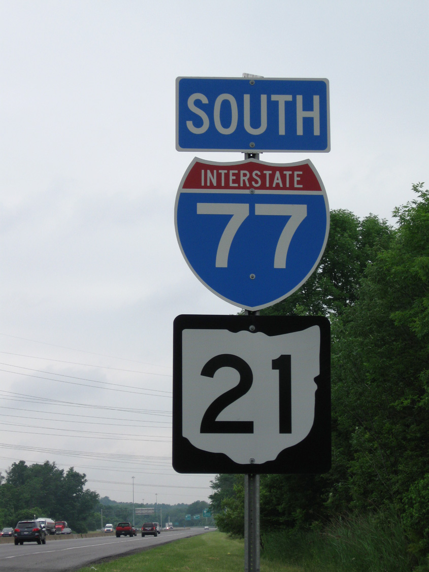
Interstate 77
Overview
Interstate 77 connects the eastern Great Lakes region with Appalachia and the Southeast. The freeway begins at Cayce on the south side of Columbia, following the Southeastern Beltway to Fort Jackson and I-20 near Forest Acres. The remainder of the route in South Carolina leads north to Rock Hill and the Charlotte metropolitan area.
Within the Tar Heel State, I-77 travels directly through the Queen City of Charlotte, serving Downtown in conjunction with Interstate 277, the John Belk and Brookshire Freeways. Leading north from Uptown Charlotte to Huntersville and Mooresville, I-77 constitutes a heavily traveled commuter route with Express Toll Lanes accompanying the route. The freeway remains well traveled to Statesville and the cross roads with Interstate 40.
I-77 north from Statesville to Fort Chiswell, Virginia is a rural but busy truck route. The stretch is punctuated by the Blue Ridge Mountains, which offers both scenery and potentially travel foggy conditions through Carroll County. A nearly nine mile overlap takes I-77 west along Interstate 81 to Wytheville. Coinciding with U.S. 11 and U.S. 52, cardinal directions along I-77/81 run opposite one another in what is sometimes referred to as a wrong-way concurrency.
Resuming a northward heading from Wytheville, Interstate 77 traverses a series of mountains to Bluefield, West Virginia. Tunnels take the route below Big Walker Mountain and East Mountain. Within the Mountaineer State, I-77 transitions into a toll road at U.S. 460 outside Princeton. The West Virginia Turnpike takes the route north to Beckley, where it combines with I-64 en route to Charleston.
Running along the Kanawha River into the capital city, I-64 and I-77 separate outside Downtown, with I-77 turning northeast briefly to Interstate 79. I-79 joins Charleston with Morgantown and Pittsburgh while I-77 remains along the former U.S. 21 corridor north to Parkersburg and Marietta, Ohio.
Advancing north through the Buckeye State, Interstate 77 stays rural to Cambridge, where it crosses paths with I-70. The route becomes increasingly busy from New Philadelphia into Canton, where U.S. 62 overlaps from separate east and west freeways. Suburban type development continues along the I-77 corridor from there north to Akron.
Interstate 77 forms an L-shaped route through Akron between I-277/U.S. 224 and a three mile overlap with I-76 south of Downtown. The freeway stays westerly to Ohio State Route 21 (former U.S. 21) near Fairlawn, where it makes the final turn toward the Cleveland area. I-77 and SR 21 parallel one another north to Independence and the Willow Freeway leading into the Forest City. The route concludes at Interstate 90 just south of Downtown.
Major Projects
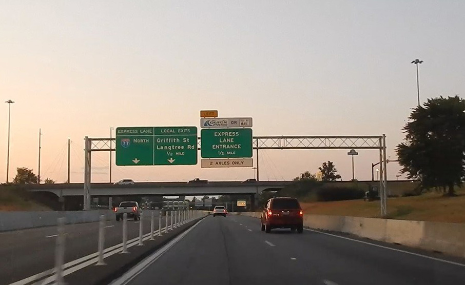
Within Iredell and Mecklenburg Counties north of Charlotte, the I-77 Express Lanes project rebuilt 26 miles of freeway. The project added one or two High Occupancy Toll (HO/T) lanes between Exit 11 / I-277 and Exit 36 / NC 150. The lanes run in tandem with the free general purpose lanes, but incorporate a variable toll rate on single occupant vehicles or HOV-2 traffic. HOV-3 eligible vehicles are permitted to use the roadway free of charge. Estimated to cost $647 million and highly contested by area residents, the public-private partnership based project was expected to take three years to complete.5 Weather, construction delays and design changes pushed work beyond the end of 2018.6
I-77 north at Catawba Avenue in Cornelius, North Carolina. 07/28/19
Work on the I-77 Express Lanes was announced by the I-77 Mobility Partners LLC for November 16, 2015. Construction took place in the median of Interstate 77, starting in area south of Exit 23 and north of Exit 28, with occasional lane shifts and closures take place during overnight hours.5 The first section of the I-77 Express Lanes opened to traffic on June 1, 2019. The 15 mile long segment runs between Hambright Road (SR 2117), north of I-485 in Huntersville, and NC 150 (Exit 36) in Mooresville. The remaining 11 miles south to Interstate 277 (Exit 11) in Charlotte opened on November 16, 2019. Overall construction on the project continued to December 2020.
 Parallel U.S. Routes
Largely following the original route of U.S. 21, Interstate 77 parallels or overlaps with U.S. 21 from Columbia, South Carolina to Wytheville, Virginia. Northward through West Virginia to Cleveland, Ohio, I-77 replaced U.S. 21, which was truncated in stages between 1974 and 1979.
History
With just two lanes, the West Virginia Turnpike opened to traffic on November 8, 1954. The toll road was later incorporated as parts of both I-64 and I-77. The project upgrading the turnpike from two to four lanes was completed on September 2, 1987.1
The 4,200 foot long Big Walker Mountain Tunnel in western Virginia took five years to build. Costing $30 million, the first mountain tunnel constructed in the state opened in 1972.2
Interstate 77 ended at Charlotte, North Carolina from the north until June 23, 1969, when the American Association of State Highway Officials (AASHO) approved the extension to Columbia, South Carolina.
Completion of I-77 southward to I-26 was formally recognized by the American Association of State Highway and Transportation Officials (AASHTO) on April 22, 1995. This extension lengthened Interstate 77 south from its previous end at I-20 to I-26. Interstate 326, which was briefly designated on the Southeastern Beltway between I-26 and S.C. 48 south of Columbia, was subsumed by the extended I-77. The gap between I-20 and S.C. 48 was closed prior to the renumbering. The Temporary Interstate 77, signed on I-20 and I-26 around Columbia, was also eliminated in 1995.
$36.3 million in construction at Exit 82 in Rock Hill, South Carolina improved the interchanges at Cherry Road (U.S. 21) and S.C. 161 (Celenese Road). Linking the two exchanges, a collector distributor roadway was added along both sides of I-77. Work also included widening the I-77 bridge over the Catawba River. This project was complete by September 2004.3
Route Information
Mileage
South Carolina – 91.05
Cities – Columbia, Rock Hill
- Junctions –

North Carolina – 105.50
Cities – Charlotte, Mooresville, Statesville
Junctions –

Virginia – 69.40*
Cities – Wytheville, Bluefield
- Junctions –
West Virginia – 187.21**
Cities – Bluefield, Princeton, Beckley, Charleston, Parkersburg
- Junctions –
Ohio – 160.13
Cities – Marietta, Dover, Canton, Akron, Cleveland
Junctions –
Source: December 31, 2021 Interstate Route Log and Finders List
* – 8.80 miles on I-81
** – 63.88 miles on I-64
I-77 Annual Average Daily Traffic (AADT)
| Location | Vehicles per day |
|---|---|
| Columbia, SC | 95,000 |
| Stover, SC | 43,600 |
| Rock Hill, SC | 89,300 |
| Fort Mill, SC | 130,400 |
Source: 2018 AADT – SCDOT Traffic Counts 2009-2018
Interstate 77 was constructed initially from Wytheville north to Princeton, West Virginia. This stretch includes the Big Walker Mountain Tunnel, which opened in 1972, and the East River Mountain Tunnel at the state line, which was completed in 1974.
Interstate 77 shares a 3.1-mile overlap with Interstate 76 through the city of Akron, Ohio. The portion of I-77 northwest from SR 162 to SR 18 was the last to be completed in the state. It opened fully in 1974.7
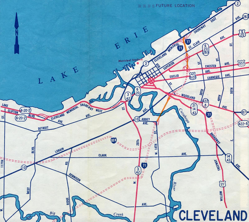
Early 1960s maps for Ohio showed I-71 and I-77 overlapped along the Innerbelt Freeway north to the Cleveland Memorial Shoreway. The Shoreway was proposed as the mainline for I-90 west from there to the unconstructed Parma Freeway. The Parma Freeway was to run south from the Shoreway to the Northwest Freeway (I-90 today) and York Road at North Royalton.

The original interchange layout joining Interstate 77 (Willow Freeway) with Interstate 90 (Innerbelt Freeway) – 1990 Cuyahoga County Engineers Map.
As part of the Innerbelt Project in Cleveland with I-71 and I-90, changes were made at the north end of Interstate 77. The southbound entrance ramps from 9th and Ontario Streets were removed and loop ramps along I-90 east replaced with a single ramp to E 9th Street north. This movement to the southbound beginning of Interstate 77 was replaced by an upgraded boulevard along Orange Avenue (U.S. 422/SR 14) to 30th Street.
Prior work of the Innerbelt Project eliminated the seldom used eastbound ramp from I-90 to I-77 south and the northbound ramp from I-77 north to I-90 west. Both ramps involved sharp curves with conflict points. They closed permanently on April 10 and 11, 2011, with Interstate 490 prominently signed to accommodate the former movements.4
 Photo Guides
North End  – Cleveland, Ohio
![]() North at
North at ![]()
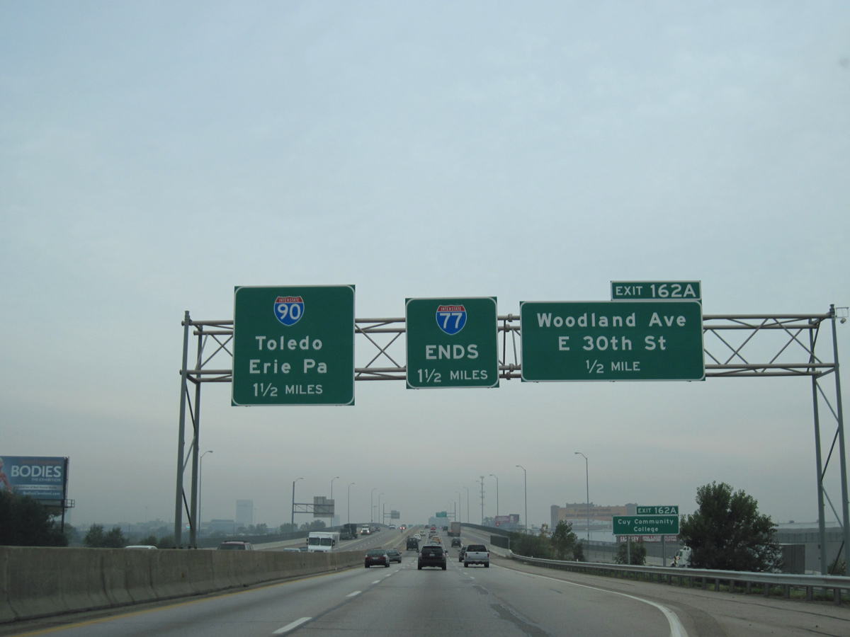
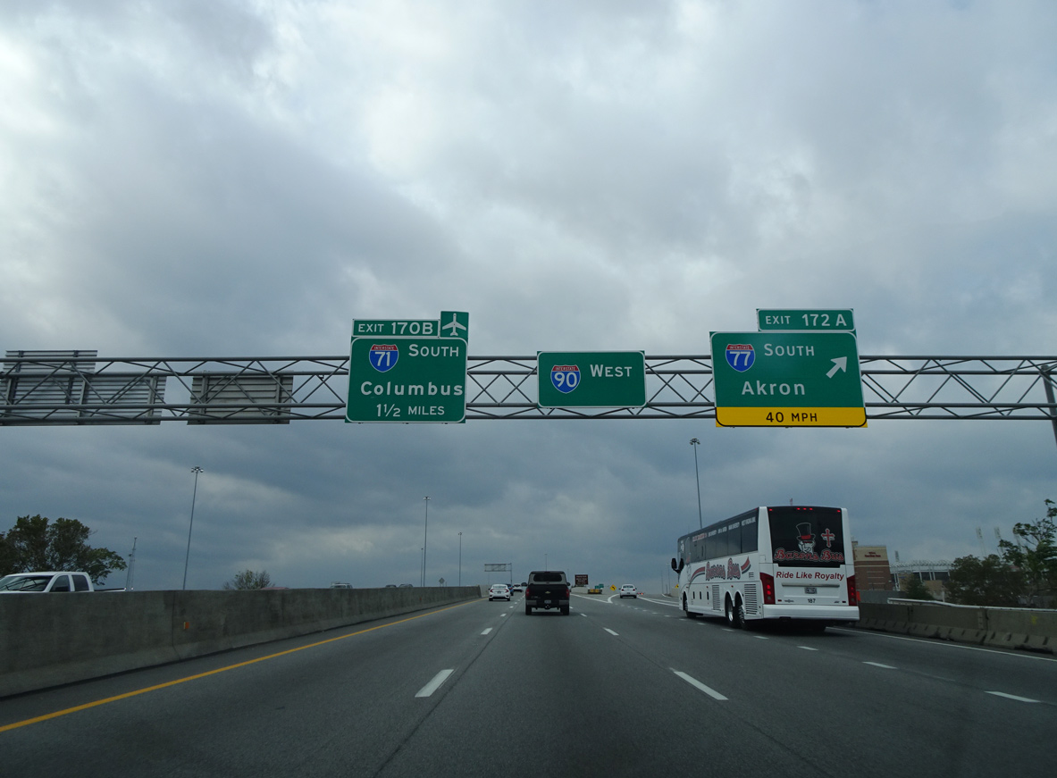
Leaving the four level interchange with Interstate 490, an end sign for I-77 appears next to the first overhead for Interstate 90.
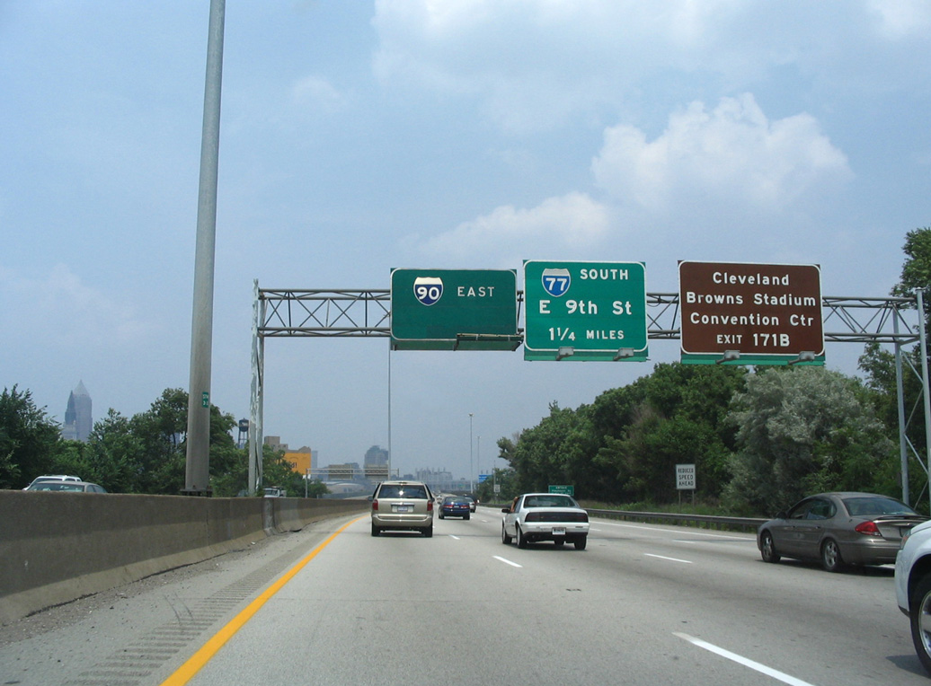
All signs for I-90 on I-77 north were changed to display Erie only as the westbound ramp to I-90 closed in April 2011. 09/30/10
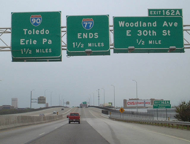
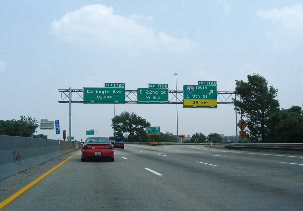
Four off-ramps depart from the northernmost mile of Interstate 77 starting with Exit 162 A to parallel Woodland Avenue (U.S. 422/SR 8) at the Central and Industrial Valley neighborhoods. 09/30/10
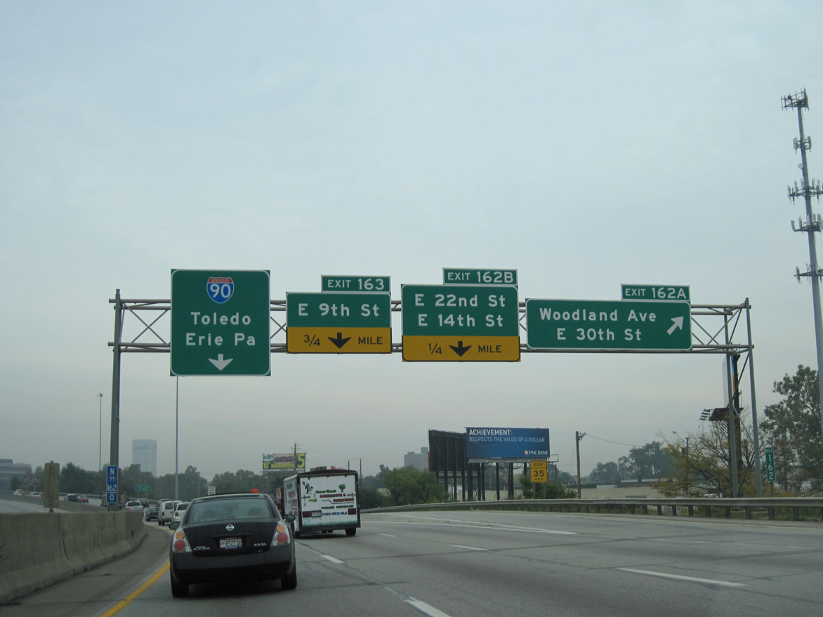
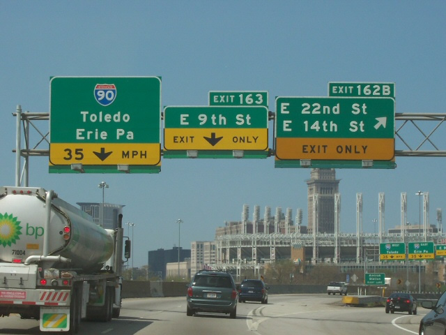
Three lanes of Interstate 77 north proceed to Exit 162 B for E 14th Street north to Downtown and E 22nd Street to Central Cleveland. I-77 north defaults onto I-90 east beyond the loop ramp for E 14th Street south. 09/30/10
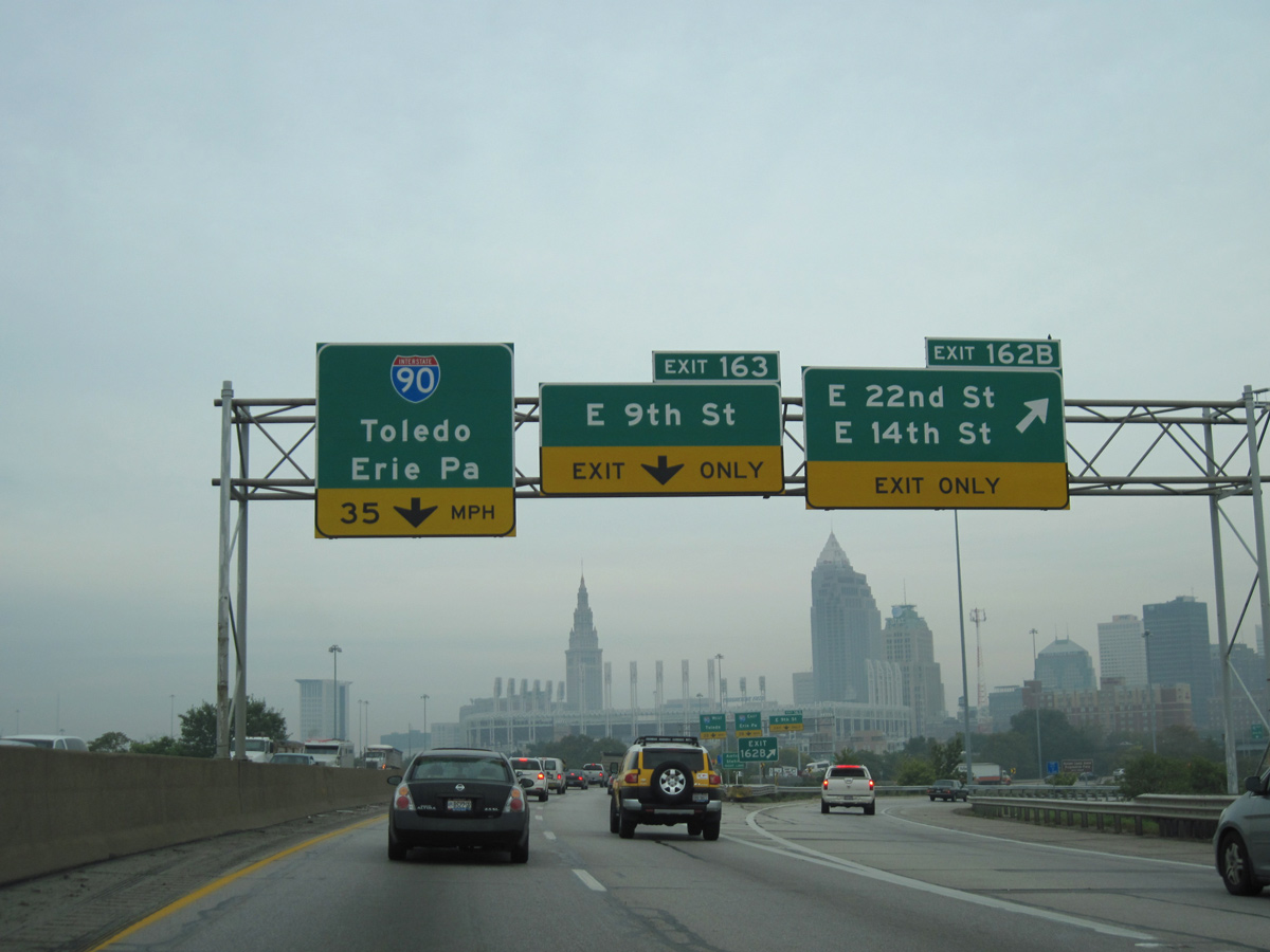
Progressive Field (home of the MLB Cleveland Guardians) comes into view as Exit 162 B departs for E 14th Street north to U.S. 20 (Euclid Avenue). I-90 encircles Downtown along the Innerbelt Freeway. Construction finished in October 2016 replaced the viaduct built in 1959 across the Cuyahoga River leading south from I-77. 09/30/10

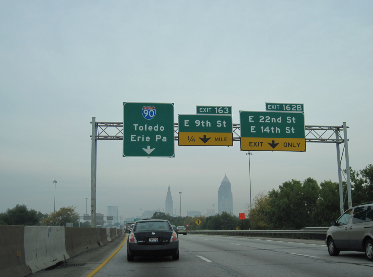
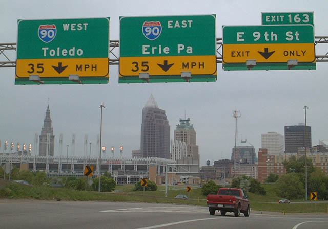
Northbound I-77 at the former westbound ramp for Interstate 90 toward Toledo. This ramp was removed as part of the Innerbelt Project. 09/30/10
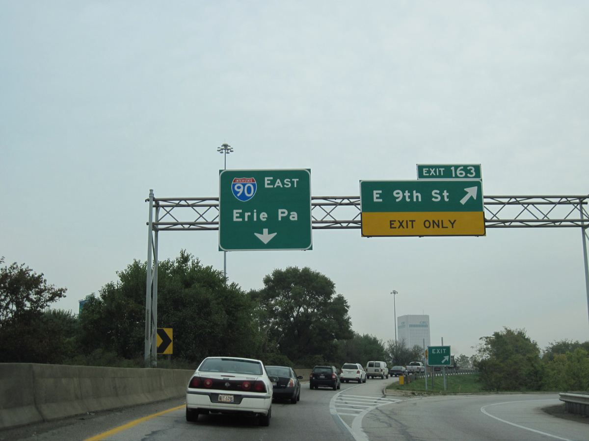
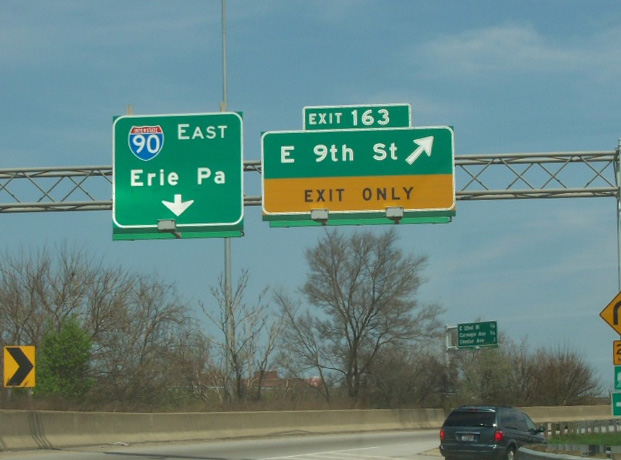
Exit 163 loops onto E 14th Street south ahead of Orange Avenue (U.S. 422/SR 8) for E 9th Street, Progressive Field, Rocket Mortgage FieldHouse (home of the NBA Cleveland Cavaliers) and Public Square. A single lane connects with I-90 east toward Erie, Pennsylvania. 09/30/10
![]() West at
West at ![]()
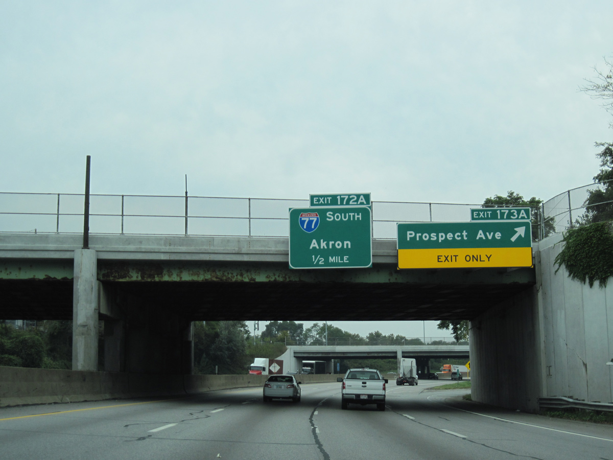
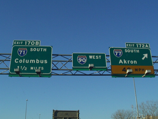
One half mile north of the wye interchange (Exit 172 A) with I-77 south on I-90 west. Exit 173 A leaves here for Prospect Avenue, one block south of U.S. 20 (Euclid Avenue). 09/30/10
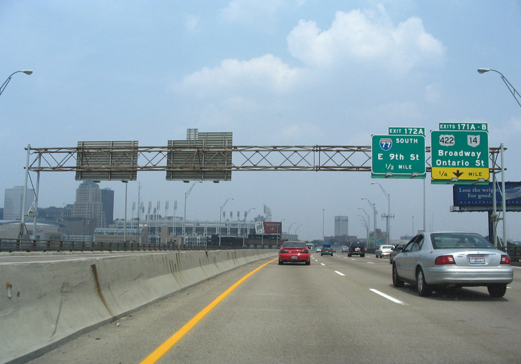
Interstate 90 remains below grade by the Cedar Avenue and E 22nd Street overpasses ahead of Exit 172 A for I-77. 09/30/10
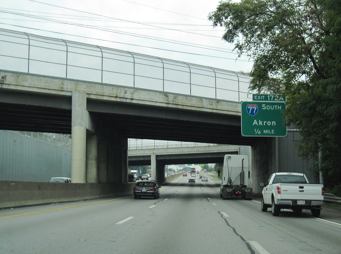
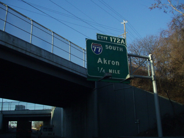
Interstate 77 heads 30 miles south from Exit 172 A to Akron. Photo by Eric Stuve (10/15/17).
North End Throwback
![]() North at
North at ![]()
Replaced button copy signs posted 1.5 miles ahead of the Interstate 77 end at I-90 outside Downtown Cleveland. 05/25/02
With Jacobs Field in the background, button copy signs advised motorists of the sharp ramp for Interstate 90 west toward Toledo as Exit 162 B parted ways for adjacent E 22nd and 14th Streets. Photo by Tim Kubat (04/06).
A directional T interchange formerly joined the north end of Interstate 77 with both directions of I-90 (Innerbelt Freeway). The southbound I-77 entrance ramp from E 14th Street included a connection to the westbound ramp from I-77 north as well. 05/25/02
Replaced signs at the I- 77 northbound separation for Exit 163 / E 9th Street into Downtown Cleveland and Interstate 90 east. Erie, Pennsylvania is 96 miles to the northeast. Photo by Tim Kubat (04/06).
![]() East at
East at ![]()
The eastbound ramp from Interstate 90 to I-77 south closed permanently by April 11, 2011. The 1959 truss bridge carrying I-90 across the Cuyahoga River was fully demolished on July 12, 2014. Construction on the replacement commenced afterwards. The $273 million project wrapped up in Octotober 2016.
Leading away from the four level interchange with I-71, the Innerbelt Freeway turned northward by Industrial Valley toward both E 9th Street and Interstate 77 south at Exit 172 A. Photo by Steve Hanudel (06/18/06).
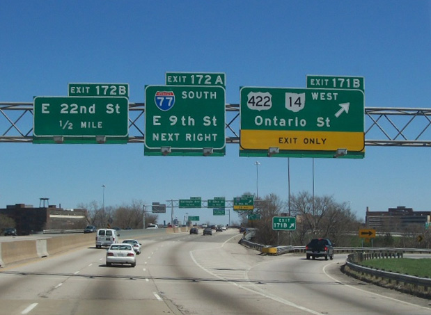
Exits 171 A-B and 172 A departed in quick succession from the north end of the I-90 viaduct. U.S. 422/SR 14 originate from U.S. 20 at Public Square and run south along Ontario Street to Orange Avenue. Interstate 77 parallels the pair to E 30th Street. Photo by Steve Hanudel (06/18/06).
New ramps as part of the Innerbelt Project join E 9th Street to provide access to U.S. 422/SR 14 (Orange Avenue). The ramp for I-77 south permanently closed. Photo by Tim Kubat (04/06).
A sharp ramp (Exit 172 A) parted ways with I-90 east for both E 9th Street north to Jacobs Field and Interstate 77 (Willow Freeway) south. Innerbelt Project work reconfigured this exit to improve the ramp geometry for 9th Street while eliminating the prong for I-77. Photo by Steve Hanudel (06/18/06).
![]() West at
West at ![]()
Passing under Cedar Avenue on I-90 west, one quarter mile ahead of the original directional T interchange (Exit 172A) with Interstate 77 south. Photo by Kevin Vance (01/22/02).
Replaced signs at the southbound beginning of Interstate 77 from the Innerbelt Freeway west. Early 1960s Ohio maps showed I-71 overlapping with I-90 west 1.25 miles from here to the Medina Freeway. Photo by Kevin Vance (01/22/02).
South End  – Cayce, South Carolina
![]() South at
South at ![]()
![]()
![]()
![]()
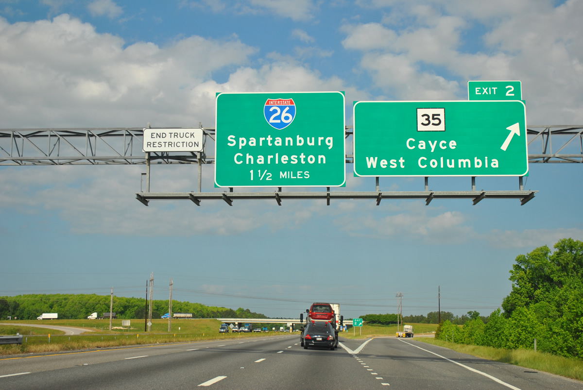
The first sign for Interstate 26 appears as I-77 south enters the diamond interchange (Exit 2) with S.C. 35. This exit opened to traffic with the 12th Street Extension south from the city of Cayce in December 1999. 04/16/12
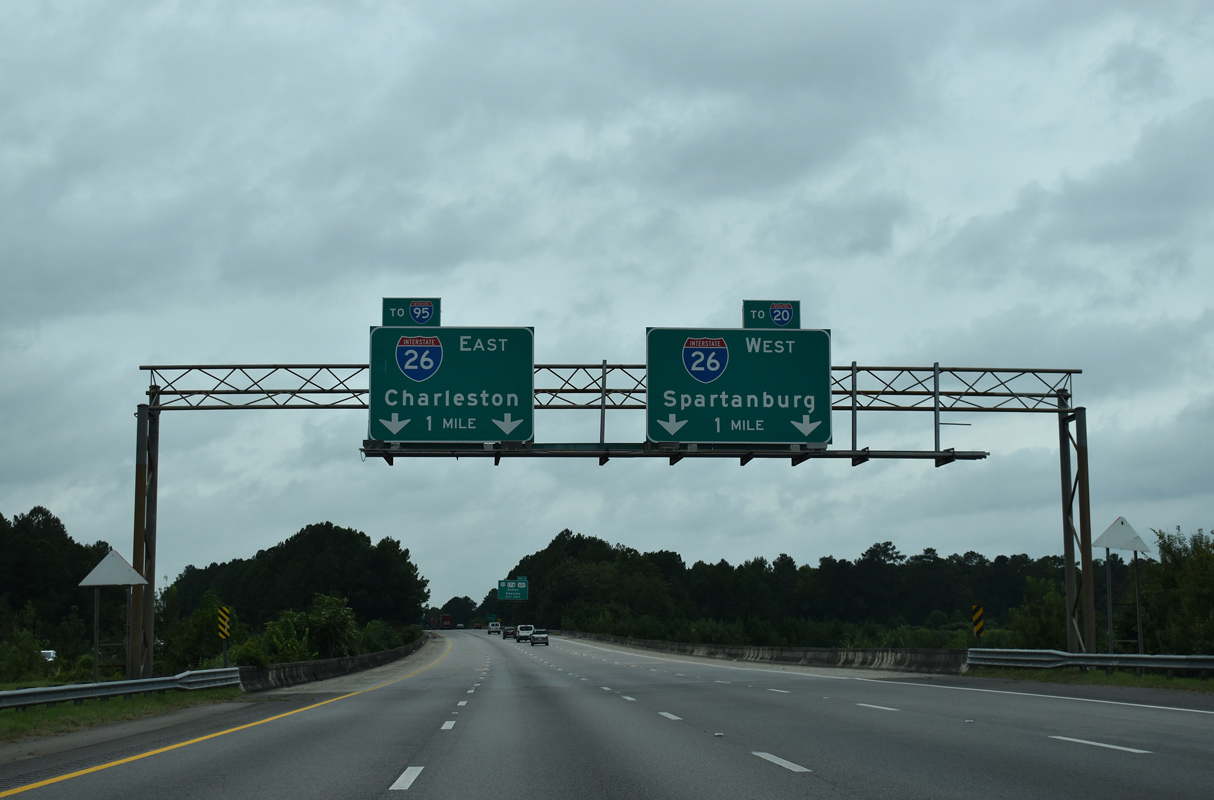
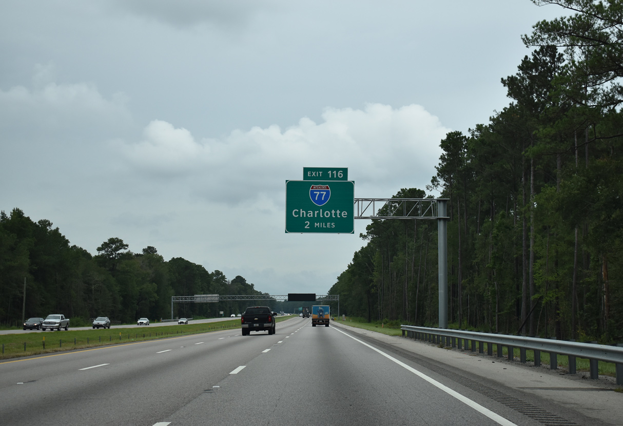
I-77 south spans an area of wetlands one mile from Interstate 26. Trailblazers affixed to the overheads reference the connections with I-20 (Malfunction Junction), eight miles to the north, and I-95 for motorists headed to Georgia and from the Great Lakes region. 09/20/21
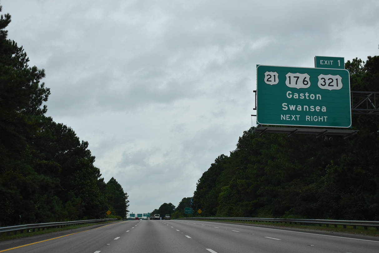
Exit 1 separates from the southbound mainline for an extend ramp and flyover to U.S. 21-176-321 and Fish Hatchery Road. 09/20/21
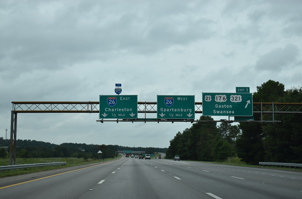
U.S. 21/176/321 parallel I-26 north into Cayce and south to a nearby split. Fish Hatchery Road stems west from the ramp end into the town of Pine Ridge. 09/20/21
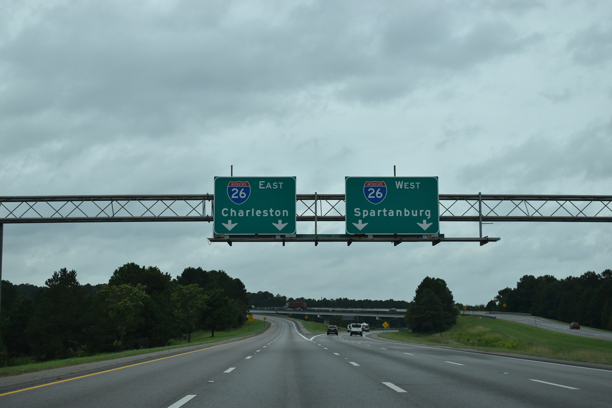
Interstate 77 ends as two lanes turn northwest along I-26 to West Columbia, Greenville and Spartanburg. The mainline defaults onto a flyover leading south toward Orangeburg and Charleston. 09/20/21
![]() West at
West at ![]()
![]()
![]()
![]()
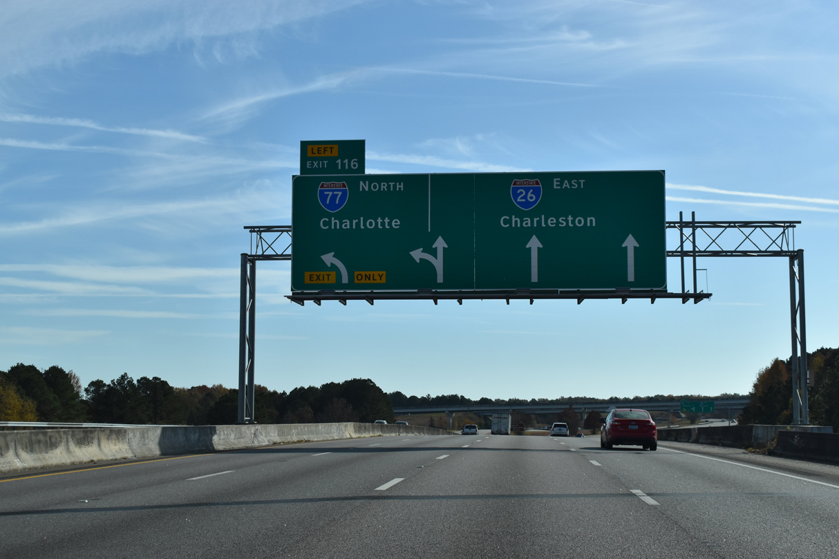
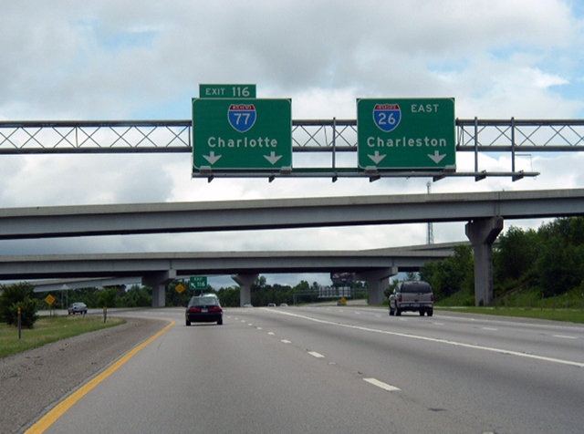
Interstate 26 passes through an area of industrial parks and distribution centers at Dixiana ahead of the directional T interchange (Exit 116) with I-77 north. 09/16/21
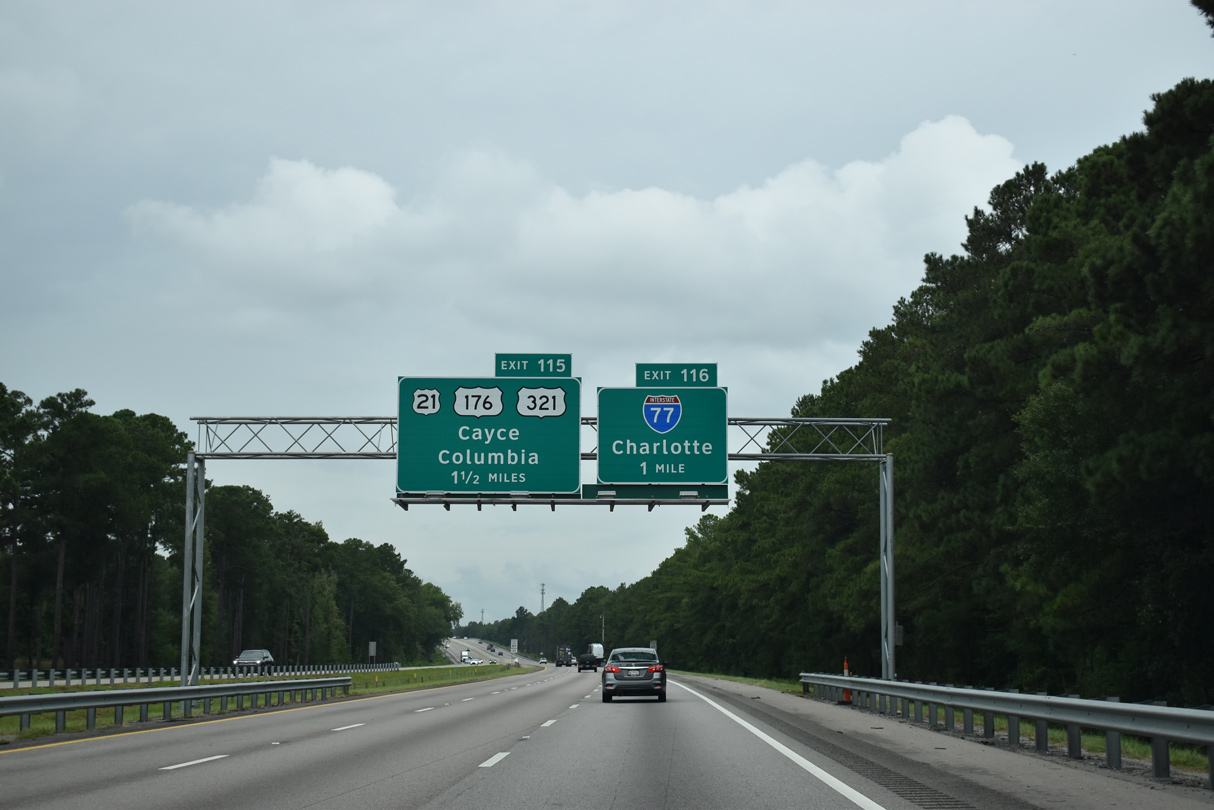
Back to back ramps leave I-26 west for I-77 north to Fort Jackson and Charlotte and U.S. 21-176-321 north into Cayce. The initial five mile stretch of I-77 east opened as S.C. 48 in August 1986. This segment was previously designated as Interstate 326, but it was never signed in the field. 09/16/21
Exit 116 leaves I-26 west for I-77 (Southeastern Beltway) north at Cayce. Interstate 77 reaches Downtown Charlotte, North Carolina in 101 miles. 09/16/21
![]() East at
East at ![]()
![]()
![]()
![]()

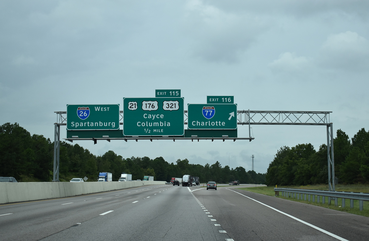
Heading south from S.C. 302, two additional exits over the ensuing two miles join I-26 east with the city of Cayce. Exit 115 departs next for U.S. 21-176-321 (Charleston Highway) adjacent to ramps with I-77. 11/21/21
Construction from 2014 to 2016 extended the six lane portion of Interstate 26 southward into Calhoun County. The widening added a third southbound lane through the directional T interchange (Exit 116) with I-77 north. 11/21/21
The next APL for I-77 north at Exit 116 appears at the U.S. 21-176-321 (Charleston Highway) underpass. I-77 (Southeastern Beltway) comprises a commuter route for the growing suburbs of Cayce, eastern reaches of Columbia and the Fort Jackson area to Blythewood. 11/21/21
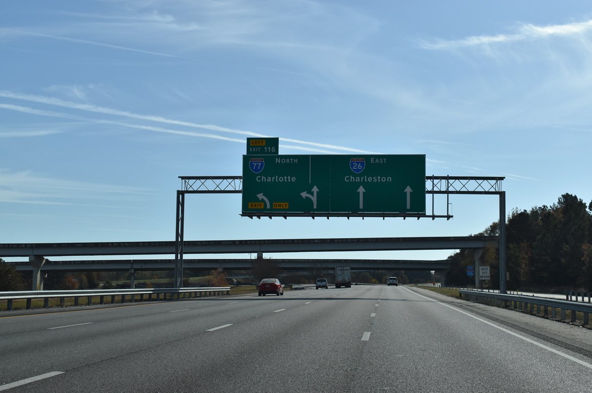
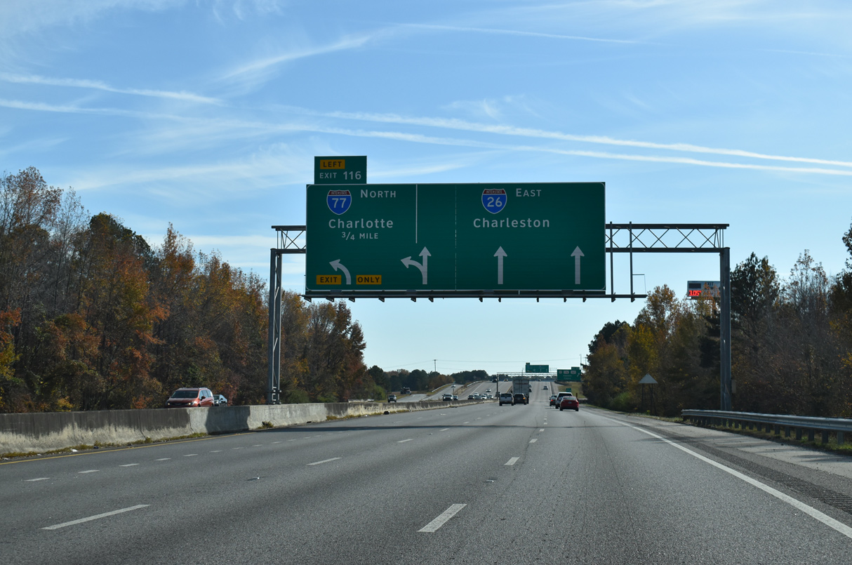
Left Exit 116 separates from I-26 east with two lanes for Interstate 77 north to Rock Hill and Charlotte. Flyovers here also connect the freeway end with Charleston Highway and Fish Hatchery Road to the west. 11/21/21
![]()
![]()
![]() South at
South at ![]() Fish Hatchery Road
Fish Hatchery Road
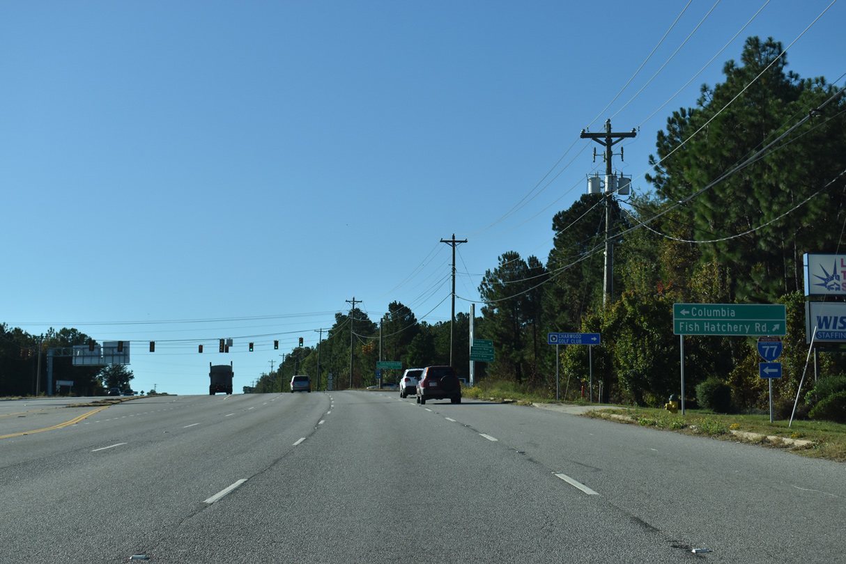
U.S. 21/176/321 (Charleston Highway) run just west of the systems interchange joining I-26/77 in south Cayce. An entrance ramp connects Charleston Highway and Fish Hatchery Road (Road 73) with the northbound beginning of Interstate 77. 10/15/23
U.S. 21/176/321 (Charleston Highway) run just west of the systems interchange joining I-26/77 in south Cayce. An entrance ramp connects Charleston Highway and Fish Hatchery Road (Road 73) with the northbound beginning of Interstate 77. 10/15/23
South End Throwback
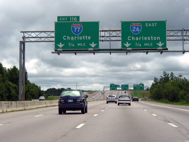
I-26 east expands to four lanes ahead of both Exit 115 to U.S. 21-176-321 and the northbound beginning of I-77. These signs were replaced by 2007; That set was replaced again in 2016 with an arrow per lane overhead. Photo by Chris Patriarca (06/08/03).
Prior to 2016, Interstate 26 reduced to a four lane rural freeway from I-77 south to Summerville. I-77 comprises a six lane freeway east toward Fort Jackson. Photo by Chris Patriarca (06/08/03).
Sources:
- Celebrating the 50th Anniversary of the Eisenhower Interstate Highway System: Previous Interstate Facts of the Day by the Federal Highway Administration (FHWA).
- “Highway System’s Impact Vast.” Richmond Times-Dispatch (VA), October 7, 1991.
- “Officials: Interstate construction at halfway point.” The Herald, South Carolina, October 5, 2003.
- “Two Interstate 77/90 Ramps to Close Permanently as Part of Innerbelt Work.” Ohio Department of Transportation, April 5, 2011.
- “Construction on I-77 toll lanes to begin Monday.” WCNC (Charlotte, NC), November 12, 2015.
- “Northern Section Of I-77 Toll Lane Project Opens Saturday.” WFAE (Charlotte, NC), May 31, 2019.
- Route 77 – The Unofficial Ohio State Highways Web Site (John Simpson).
http://pages.prodigy.net/ john.simpson/highways/077.html
Page updated January 25, 2024.