Interstate 73

Overview
Interstate 73 was first planned in 1991 as part of High Priority Corridor 5 as defined by the Intermodal Surface Transportation Efficiency Act of 1991 (ISTEA). Amendments to the routing of I-73 occurred in 1995 with the passage of the National Highway System Designation Act and in 1998 with the passage of the Transportation Efficiency Act for the 21st Century (TEA-21). In addition to providing for I-73, High Priority Corridor 5 includes the extension of the preexisting Interstate 74 from Cincinnati, Ohio, east to Myrtle Beach, South Carolina.
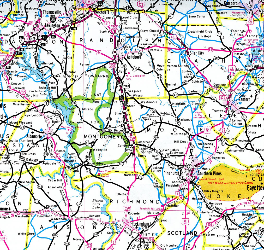
Presently Interstate 73 runs in tandem with I-74 and U.S. 220 from a point south of Ellerbe northward to Randleman, and then without I-74 from there to the Greensboro Outer Loop (Painter Boulevard). U.S. 220 extends north as a freeway to Interstate 40 in Greensboro, while I-73 turns northwest alongside U.S. 421 to meet I-40 near Piedmont Triad International Airport (PTI). U.S. 421 departs for I-40 west while I-73 combines with Interstate 840 northward to Joseph M. Bryan Boulevard.
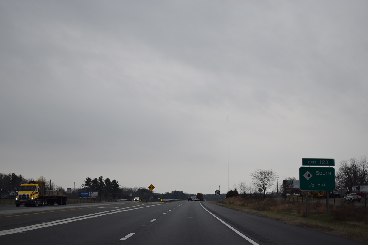
Overtaking Bryan Boulevard around the north side of PTI Airport, I-73 turns west to NC 68. Interstate 73 intertwines with NC 68 before angling northeast 7.5 miles to combine with U.S. 220 at the Haw River. The two routes extend 4.5 miles to Stokedale and the north end of NC 68 at Exit 123.
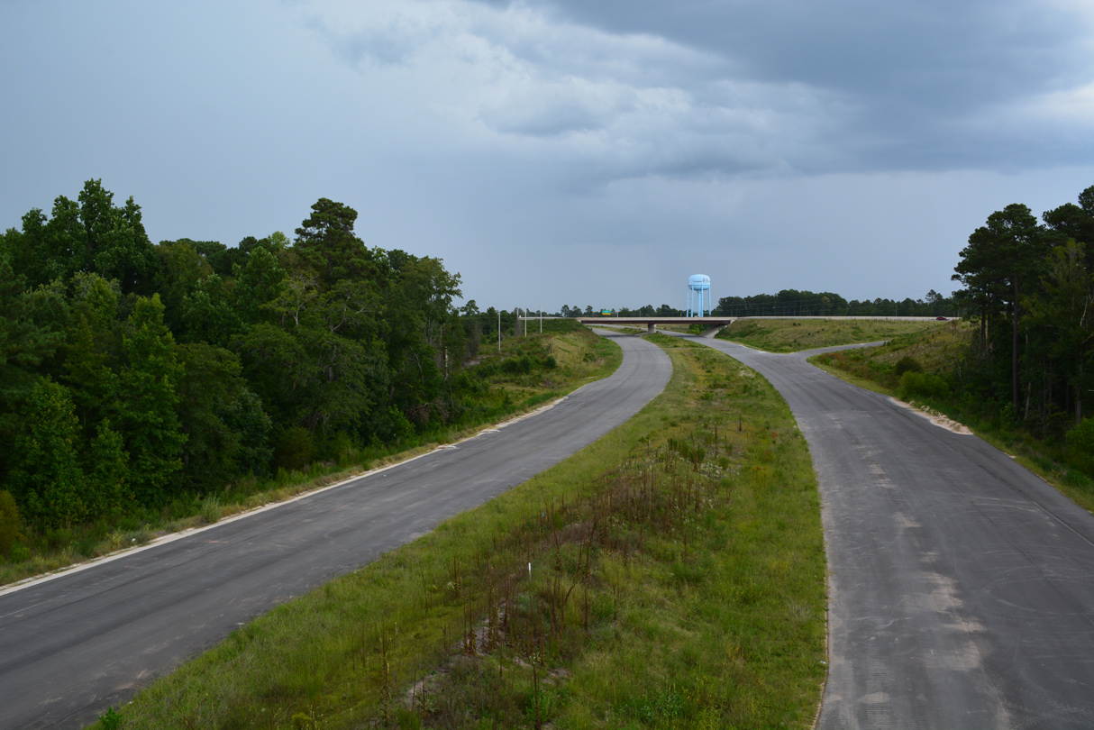
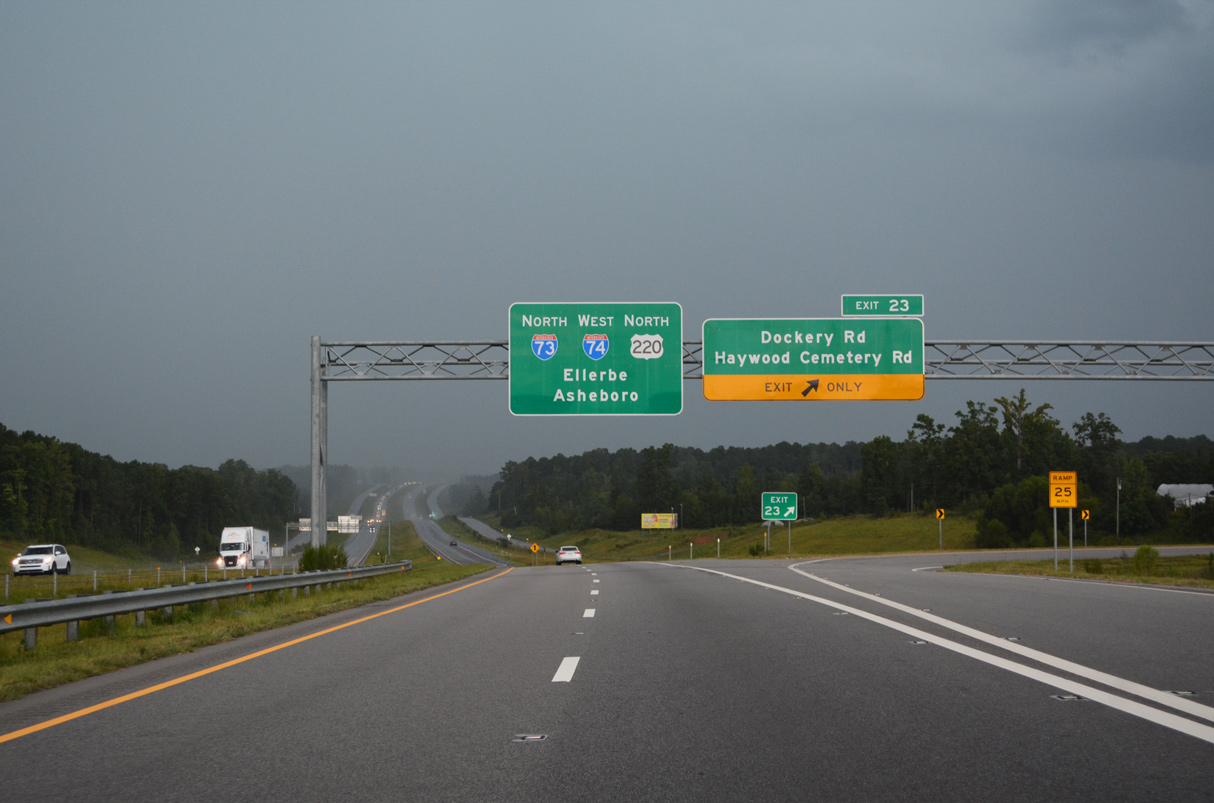
The next section of I-73/74 to open is the Rockingham Bypass, an overall 10.5 mile long route branching southwest from U.S. 220 by Harrington Road (SR 1304) to U.S. 74 at U.S. 74 Business. Visible east of the Harrington Road overpass here, roadways for the northernmost section of the bypass were built during the first phase of the project underway from March 2014 to June 2018. 08/14/21
High Priority Corridor
Interstate 73 in its entirety is part of High Priority Corridor 5: I-73/74 North-South Corridor. Its designation is written into law.
 Parallel U.S. Routes
Interstate 73 runs concurrent with U.S. 220 from north of Rockingham to I-85 in south Greensboro. I-73 rejoins U.S. 220 north from Summerfield into Rockingham County. The planned route north to Roanoke continues along U.S. 220. If it were extended northwest to Michigan, I-73 would follow sections of U.S. 52, U.S. 23 and U.S. 127. The proposed route southeast to Myrtle Beach, South Carolina will coincide with U.S. 501.
History
The first time Interstate 73 and I-74 were submitted to the American Association of State Highway and Transportation Officials (AASHTO) for approval was at the Special Committee on Route Numbering meeting on April 19, 1996. During that meeting, North Carolina submitted three requests under Section 332(a)(2) of the National Highway System Designation Act of 1995. None of the three requests were approved at that time:
- Establish Interstate 73
Beginning at the intersection of U.S. Route 220 at the Virginia State Line, then southerly over U.S. Route 220 to the intersection of State Route 68 northwest of Greensboro, then southerly over U.S. Route 68 (sic) to the intersection of Interstate Route 40 in Kernersville, then southeasterly over I-40 to the intersection of U.S. Route 220 in Greensboro, then southerly over U.S. Route 220 to the intersection of U.S. Route 1 in Rockingham, then southwesterly over U.S. Route 1 to the South Carolina State Line.
The action to establish this route was continued at the April 1996 meeting, and it was subsequently amended in future iterations by North Carolina and adjacent states.
- Establish Interstate 74
Beginning at the intersection of Interstate Route 77 at the Virginia State Line, then southerly over I-77 to the intersection of U.S. 52 south of Mount Airy, then southeasterly over U.S. Route 52 to the intersection of U.S. Route 311 in Winston-Salem, then easterly and southeasterly over U.S. Route 311 to the intersection with U.S. Route 220 in Randleman, then southerly over U.S. Route 220 to the intersection of U.S. Route 74 in Rockingham then southeasterly over U.S. Route 74 to the intersection of U.S. Route 76 in Whitehall, then westerly over U.S. Route 76 to the South Carolina State Line.
The action to establish this route was continued at the April 1996 meeting, and it was subsequently amended in future iterations by North Carolina and adjacent states.
- Establish Temporary Interstate 74 – a request was made to establish a temporary designation along U.S. 52 from Interstate 40 north 11.22 miles to the intersection with North Carolina 1840. This request was disapproved in favor of “To Interstate 74.”
Once the proposals for I-73 and I-74 were resubmitted in a joint proposal by Virginia, North Carolina and South Carolina, AASHTO approved them as Interstate Highways via a mail ballot completed on July 25, 1996. The results of this ballot were approved as part of the meeting of October 5, 1996. The routes were modified into the following descriptions:
- Establish Interstate 73
Beginning at the intersection of Interstate Route 81 and Interstate Route 581 north of Roanoke, Virginia, then southeasterly over I-581 to the intersection of U.S. Route 220 at the Virginia State Line, then southerly over U.S. Route 220 to the intersection of State Route 68 northwest of Greensboro, then southerly over U.S. Route 68 (sic) to the intersection of Interstate Route 40 north of High Point, then southeasterly over I-40 to the intersection of U.S. Route 220 in Greensboro, then southerly over U.S. Route 220 to the intersection of U.S. Route 1 in Rockingham, then southwesterly over U.S. Route 1 to the intersection of State Route 9 near Cheraw, South Carolina, then southerly over S.R. 9/38 to the intersection of U.S. Route 501 near Marion, then southerly over U.S. Rout(e) 501 (sic) to the intersection of U.S. Route 701 in Conway, then southwesterly over U.S. Route 701 to the intersection of U.S. Route 17 in Georgetown, then southerly over U.S. Route 17 to the terminal interchange of Interstate Route 26 in Charleston, South Carolina.
The south end of this route, along with certain other segments, was modified in the ensuing years.
- Establish Interstate 74
Beginning at the intersection of Interstate Route 81 and Interstate Route 77 east of Wytheville, Virginia, then southerly over I-77 to the intersection of U.S. Route 52 south of Mount Airy, then southeasterly over U.S. Route 52 to the intersection of U.S. Route 311 in Winston-Salem, then easterly and southeasterly over U.S. Route 311 to the intersection with U.S. Route 220 in Randleman, then southerly over U.S. Route 220 to the intersection of U.S. Route 74 in Rockingham then southeasterly over U.S. Route 74 to the intersection of a new facility to be constructed west of Whiteville, then southerly over the new facility to the intersection of U.S Route 17 southwest of Wilmington, then southwesterly over U.S. Route 17 to the intersection of proposed Interstate Route 73 at a point yet to be determined in near Myrtle Beach, South Carolina.
Route Information
North End – Stokesdale, NC
South End – Rockingham, NC
Total Mileage – 99.43*
- Cities – Asheboro, Emery, Ellerbe, Greensboro
Branch Routes – 0
- Junctions –


Source: Source: December 31, 2021 Interstate Route Log and Finders List
* – 3.56 miles on I-840, 19.17 miles on I-74
Bob Malme covers both I-73 and I-74 extensively through his web site. Find construction information, a time table for when the next segments will open, exit lists, and more.
When first signed, I-73/74 ran just 31.5 miles from U.S. 220 south of Candor to the exchange with U.S. 64 in Asheboro. The freeway was extended south to Ellerbe by 2008.
South Carolina
Within the Palmetto State, Interstate 73 will begin at U.S. 17 in Myrtle Beach, using S.C. 22 along the Conway Bypass / Veterans Highway. Interstate 74 will go northeast via Carolina Bays Parkway (S.C. 31) and NC 211 to Whiteville, North Carolina. I-73 will turn northwest via U.S. 501 and U.S. 1 to the North Carolina State Line. I-73 would meet a proposed eastern extension of I-20 near Marion, South Carolina. I-73/74 were originally slated to begin in Charleston under the 1991 legislation, but it was moved back to Myrtle Beach as a result of 1995 and 1998 actions. These actions were the result of Governor Mark Sanford, then 1st District U.S. representative. Gov. Sanford heeded the objections of residents in both Charleston and Georgetown Counties relating to historical and ecological impacts that may incur with the construction of Interstate 73. These legislative actions were reconsidered in 2004, but unchanged, reaffirming that I-73 will not continue south of Myrtle Beach. No southern extension to the I-73 high priority corridor was included in the 2005 Safe, Accountable, Flexible, Efficient Transportation Equity Act – A Legacy for Users (SAFETEA-LU); however, a significant sum of money was appropriated in that bill to I-73 north of Myrtle Beach in South Carolina.
A 2003 article in The Sun News (Myrtle Beach) indicated that state officials touted a southward extension of Interstate 73 to Georgetown, potentially in the overall U.S. 17-701 corridor, and ultimately to I-26 in Berkeley County. In 2003, funding of the South Carolina segment of I-73 was inserted into the federal budget by U.S. Rep. Henry Brown, R-SC in the form of $3 million pertaining to preliminary studies. The new routing would not affect Charleston County and would avoid U.S. 701, site of the previous I-73 proposed alignment. These areas are important in that they relate to the population proportion of those who opposed the original routing. With all of that stated, the U.S. 701 corridor was in need of improvements such as widening. Funding for this and other related projects however was not readily available and thus the discussion of extending I- 73 southward grew out of the funding debate as the designation would allow U.S. 701 related projects to receive federal funding. Other environmental concerns and objections from additional conservationists continued opposite proponents of Interstate 73 progress with their agenda.1
A later development surrounded the routing of Interstate 73 to the north in Marion County, South Carolina. Announced in early October 2003, plans for I-73 suggested the 1997 alignment through the Pee Dee county. This announcement countered an August 2003 proposal by the South Carolina Department Transportation of four routes, none of which enter the northern half of Marion County, for I-73. Representative Jim Battle, D-Nichols met with delegates in Washington, D.C. to request $4 million in funds for Environmental Impact Studies and Right-of-way purchases for the Marion County corridor. It was anticipated that the 90 mile long corridor will run north to south between the towns of Marion and Mullins while joining U.S. 501 and S.C. 38. When finalized, the Interstate 73 project would take about 10 years to complete and cost between $1 and 2 billion. 3 A proposal arose in December 2003 to construct I-73 as a toll road, and that remains one of many options on how to fund the project.4
For more on the South Carolina section of Interstate 73, visit:
- National I-73/I-74/I-75 Corridor Association
- Interstate 73 in South Carolina: Environmental Impact Study
The S.C. 22 (Veterans Highway) freeway fully opened to traffic on May 4, 2001 after 15 years from planning to completion. Constructed over the course of three years at a cost of $368 million, the highway was completed six months ahead of schedule.7 The southern portion of Veterans Highway, between S.C. 90 and U.S. 17, opened on June 29, 2000. It includes the Intracoastal Waterway Bridge, which saw initial work in 1994.8 Following that portion was the completion between S.C. 90 and S.C. 905, including the crossing over the Waccamaw River on November 6, 2000.9 The 28 mile long roadway provides an easterly bypass of Conway from U.S. 501 to U.S. 17 west of Windy Hill Beach.
Construction of Interstate 73 north from S.C. 22 (Veterans Highway) to the Marion and Mullins vicinity moved closer with the final permit application submitted by SCDOT to the Army Core of Engineers on May 20, 2016. Included was a wildlife mitigation plan for the project, which involves the South Carolina Department of Transportation (SCDOT) purchasing nearly 6,000 acres of Gunter’s Island to be turned over to the South Carolina Department of Natural Resources. This land exchange would offset the 250 acres of wetlands needed for the I-73 corridor. If approved, state certification would be needed next before the project goes out for public notice.13
North Carolina
Interstate 73 in North Carolina will parallel NC 38 from the state line and join Interstate 74 to the south of Rockingham and Hamlet. U.S. 74 bypasses the two cities along a freeway, which I-73/74 will take west to a new alignment, the Rockingham Bypass. The Rockingham Bypass is a new terrain alignment under construction from U.S. 74 northeast to U.S. 220 south of Ellerbe.
The February 2016 version of the 2016-15 NCDOT STIP allocated funding for both the upgrade of U.S. 74 around Rockingham to Interstate standards and construction of the Rockingham Bypass. Construction was anticipated from 2022 to 2025.12 The 2018-2027 Draft STIP for NCDOT Division 8 included funding for completion of the I-73/I-74 Rockingham Bypass.18 Work got underway in November 2019 and runs through 2024.
North from Rockingham, Interstate 73 supplants U.S. 220 from Ellerbe to Greensboro. I-74 overlaps with I-73 north to Randleman, where it turns west to High Point. With AASHTO approving I-73 and I-74 in 1996, both were signed along the freeway for U.S. 220 opened in 1996 between Seagrove and Ulah. I-73/74 were also designated along the preexisting freeway along U.S. 220 north to U.S. 64 at Asheboro.
$700 million in transportation bonds released by Gov. Mike Easley were allocated for Randolph County, North Carolina. Of these funds, three projects were under consideration involving the I-73 and I-74 corridors. The first of which made safety improvements and upgraded U.S. 220 to Interstate standards from the Asheboro city limits northward to the Greensboro Urban Loop. This eight mile segment was scheduled for construction between 2007-08. A second major project involved the construction of an 11.5 mile section of freeway between U.S. 220 and the city of Archdale. This included the U.S. 311 connector to Interstate 73 and joined the area with Piedmont Triad International Airport (PTI). Work on this project was also scheduled for 2007-08. A third project was the upgrade of the I-73/74 rest area at Seagrove to a full tourist information center. Construction on the 20 acre site was slated for 2006.2 Funds were previously appropriated to several sections of Interstate 73 in North Carolina as part of SAFETEA-LU in 2005.
Interstate 73 was eventually completed south from Candor south to Ellerbe in 2008, as was the southwest quadrant of the Greensboro Urban Loop (Painter Boulevard). The new alignment for I-74 from I-73/U.S. 220 at Randleman northwest to Archdale opened to traffic in stages between November 2010 and June 2013. Upon completion, I-73 was made official northward from Randleman to Greensboro.
Work continued on the next section of I-73, a 9.4 mile long segment from Bryan Boulevard near PTI Airport to U.S. 220 at Haw River. Also referenced as the U.S. 220/NC 68 connector, anticipated completion advanced from April 25, 2017 to December 2016. The accelerated time line was the result of efforts by NCDOT with local and state officials, as the project ran in tandem with construction to build a taxiway bridge for Piedmont Triad International Airport (PTI) across the new freeway.11
Governor Roy Cooper and transportation officials attended a ribbon cutting ceremony on June 9, 2017 for I-73 north from Bryan Boulevard/Airport Parkway to U.S. 220 at the Haw River. Including the new taxiway bridge for PTI Airport, the project cost $176.5 million. Of the 9.4 mile section, six miles opened to traffic between U.S. 220 and NC 68 on May 19.16 The remainder between NC 68 and I-840, including the rebuilt stretch of Joseph M. Bryan Boulevard, opened to traffic on July 3, 2017.17
For more on the North Carolina section of Interstate 73, visit:
Virginia
Within Virginia, Interstate 73 is proposed to enter the state along the U.S. 220 corridor leading north from Greensboro, North Carolina. The planned route for I-73 parallels U.S. 220 from the state line north to Roanoke and replaces Interstate 581. Beyond there, plans outline overlapping I-73 with I-81 south to connect with the U.S. 460 corridor west to Blacksburg and the West Virginia state line via the “Smart Road.” The Smart Road segment of I-73 is the “proposed highway to demonstrate intelligent transportation systems authorized by item 29 of the table in section 1107(b) in the vicinity of Christiansburg.”
The segment of I-73 from Interstate 81 northeast to I-77, including the Smart Road near Virginia Tech, was initially not scheduled for construction until after 2020, and even then there were significant environmental obstacles to overcome, including the area through Narrows and Rich Creek.5
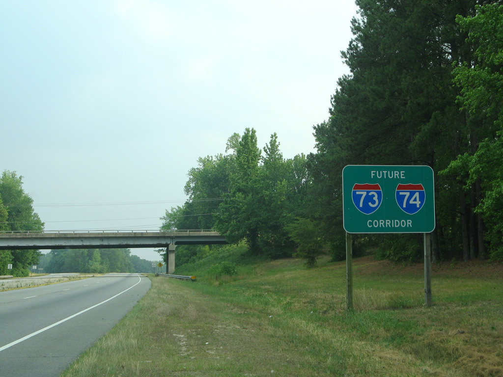
Nonetheless, five signs were installed in April 2015 along Interstate 581 and the Roy L. Webber Expressway referencing the route as the Future 73 Corridor. Costs to upgrade U.S. 220 between Roanoke and the North Carolina state line to Interstate standards were estimated then at $4 billion. Only $11 million was made available for the I-73 corridor in Virginia at the time. If all monies were available, an estimated ten years of construction would be required to complete the I-73 corridor.10
An announcement made by Ronald “Skip” Ressel, Jr., president of the I-73 Committee of Martinsville and Henry County, indicated that the I-73 project in Virginia formally ended. The corridor was envisioned to run northwest from the freeway end along U.S. 58 at Laurel Park, across Virginia Route 57 and end near Virginia Route 174 north of Martinsville.14 Preceding this news was the halting of further study for the I-73 Corridor Project by the Virginia Office of Transportation Public-Private Partnerships on February 21, 2014.15
West Virginia
In West Virginia, Interstate 73 was planned to enter from the east, following the corridor connecting Blacksburg, Christiansburg, and Roanoke in Virginia with U.S. 52 in Bluefield. The I-73/74 route through West Virginia was split into three segments: Huntington area, Huntington to Williamson (Tolsia Highway), and Williamson to Bluefield (King Coal Expressway). At Bluefield, Interstate 73 was to pick up I-74 and U.S. 52 from the south. The pair would combine in a northwesterly direction along an upgraded U.S. 52 corridor all the way to Huntington, where they would cross into Ohio.
A significant sum of money was appropriated toward the construction of the Tolsia and King Coal Highways in the 2005 SAFETEA-LU transportation reauthorization bill. However, the corridor was not envisioned as an interstate grade route, and instead to expressway standards with at-grade intersections.
Earlier estimates to bring U.S. 52 to Interstate standards in West Virginia were forecast at $2 billion. Possibly due to a lack of funding, Efforts instead focused on bringing U.S. 52 up to “corridor standards,” which includes interchanges at key junctions but not full access control.6
Resources for I-73/74 in West Virginia include:
Ohio
The Interstate 73 Corridor is probably the least likely to be constructed in Ohio, despite the federal law designating the route. As proposed in the 1995 National Highway System Act, Interstate 73 would enter Ohio via the U.S. 52 corridor. It would join with Interstate 74 between Huntington, West Virginia and a point near Lucasville, Ohio. Interstate 73 would then supersede U.S. 23 and follow it north to Portsmouth and Columbus, including the Portsmouth bypass project. Within Columbus, Interstate 73 might have followed Interstate 71 and Ohio Route 315, but those plans were not clear. The proposed route in Delaware County would follow U.S. 23 south from Waldo, then skirt the northeast edge of Delaware to U.S. 36, following that route toward Interstate 71. Then it would head northwest via U.S. 23 from Columbus toward Toledo via Marion and Ottawa. I-73 would likely loop around Toledo via I-475 or via I-280. The route would leave Ohio via the freeway along U.S. 23/223 or via U.S. 127.
“Ohio has no plans to pursue I-73,” said Joel Hunt, Ohio Department of Transportation spokesman. “It’s not part of our long-range plan.” While there are many other projects requiring funding in the Buckeye State, the Interstate 73 corridor was no longer considered. However, individual projects to upgrade roads along the corridor, including U.S. 23, were still pursued at a local level rather than a statewide level.5
Michigan
In Michigan, I-73 was proposed to follow U.S. 223 northwest from Toledo to Adrian, then turn north along U.S. 127 through Lansing to Interstate 75. Interstate 73 would then run tandem with I-75 from Grayling north to Sault Ste. Marie, but it was unclear if it would be cosigned all the way to Canada. Most of this corridor was already freeway, except for U.S. 223.
Between 1999 and 2001, the Michigan Department of Transportation (MDOT) studied the feasibility of the Interstate 73 Corridor in that state. The study was completed in December 2001, with a decision not to proceed with I-73 due to lack of funding and a lack of need along certain portions of the route. As part of this study, various corridors were considered, including an option to route the freeway through Toledo or to send it south on U.S. 127 to the Ohio Turnpike rather than using U.S. 223. On April 16, 1999, AASHTO’s Route Numbering Subcommittee approved the elimination of U.S. 27 north of Lansing and the designation of U.S. 127 over the same route. By 2001, signs for U.S. 127 appeared on the route.
Another reason why I-73 was deferred in Michigan was because the State of Ohio also stopped its feasibility study for Interstate 73. This left the freeway in doubt for both Michigan and Ohio. Furthermore no appropriations for this portion of the corridor were made in the 2005 SAFETEA-LU transportation reauthorization bill.
Due to the gap in the route from states to the south, Michigan formally abandoned long range plans for Interstate 73. However, it pursued local improvements to the route, including the section of freeway along U.S. 127 that is missing north of Lansing.5
 Photo Guides
North End 
 – Stokesdale, North Carolina
![]()
![]() North at
North at ![]()
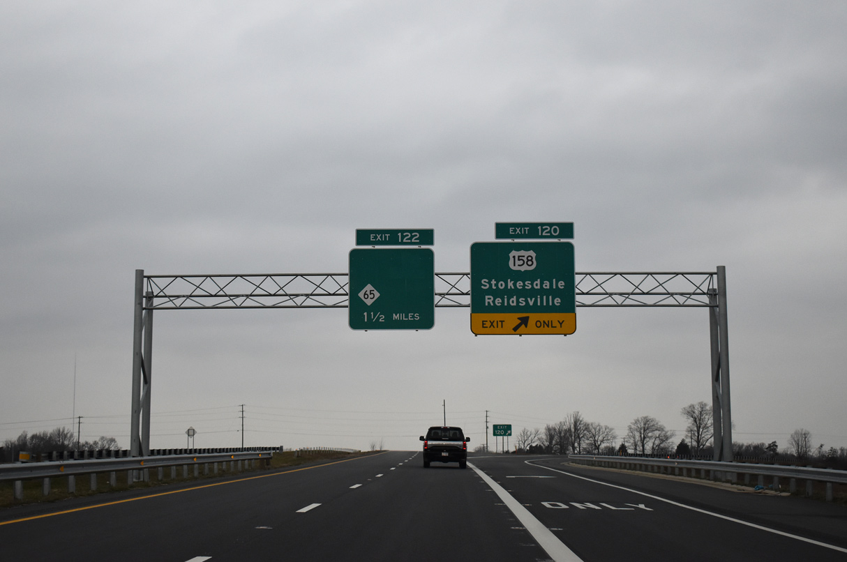
I-73 and U.S. 220 combine north of Summerfield ahead of U.S. 158 and eastern reaches of Stokesdale. 01/17/19
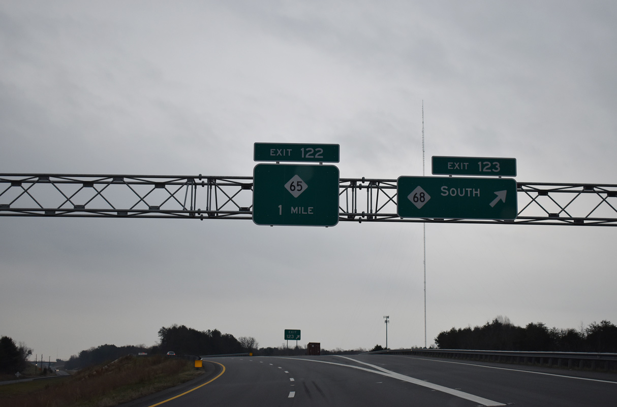
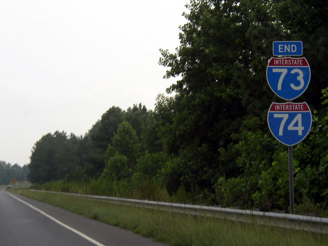
NC 65 branches east of NC 68 and the town of Stokesdale to meet Interstate 73 at the last northbound exit. 01/17/19
The final northbound confirming marker for Interstate 73 stands beyond Exit 122. 01/17/19
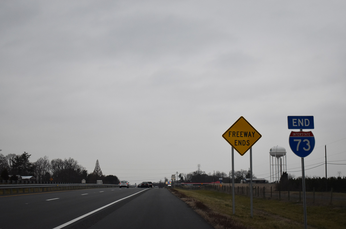
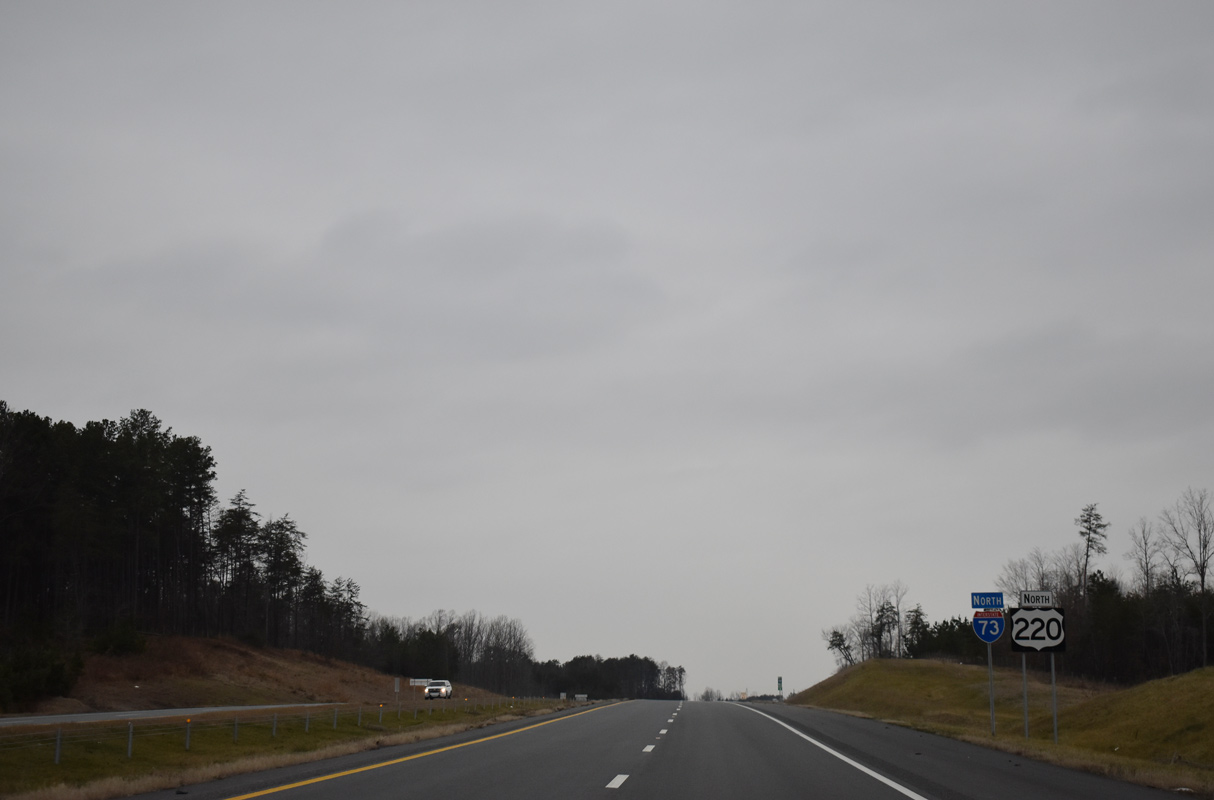
An end shield for Interstate 73 stands beyond the merge of NC 68 north onto U.S. 220. U.S. 220 continues to Madison and Mayodan. 01/17/19
![]() South at
South at ![]()
![]()
U.S. 220 upgrades to Interstate 73 at the wye interchange (Exit 123) with NC 68 south to Stokesdale. 01/17/19
The first mile marker for Interstate 73 appears beyond the gore point for Exit 123. 01/17/19
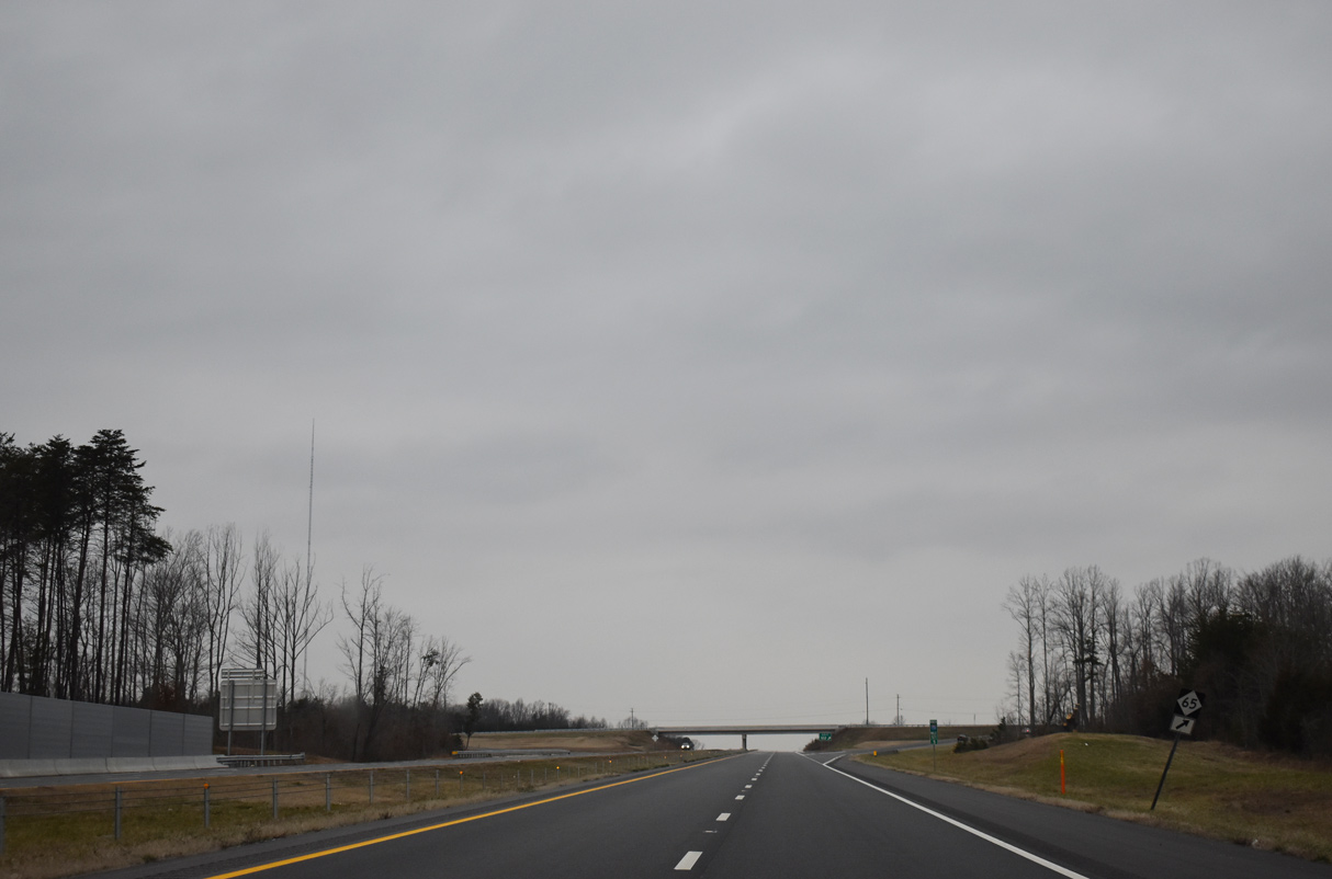
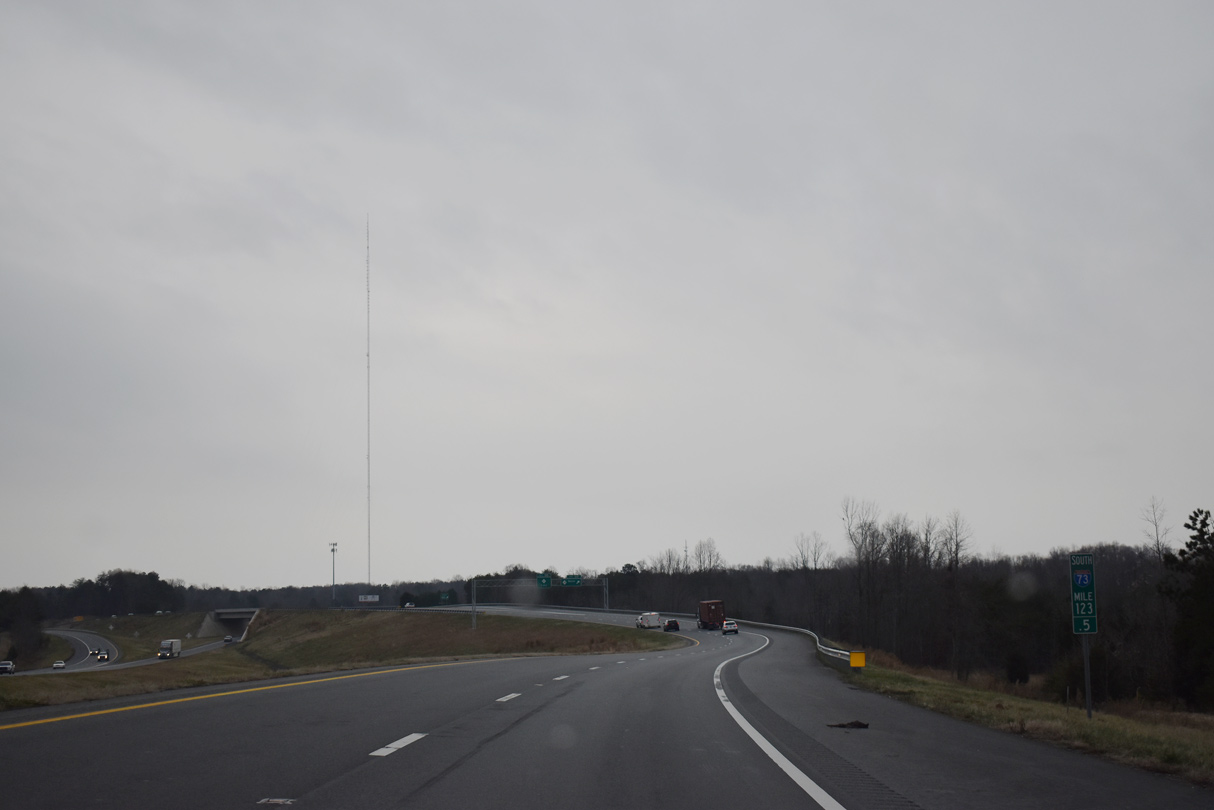
I-73/U.S. 220 bypass Stokesdale to the east en route to Greensboro. NC 68 angles southwest to the town center. 01/17/19
Interstate 73 and U.S. 220 overlap 4.5 miles southeast to Summerfield. 01/17/19
South End – north of Rockingham, North Carolina
![]() North at
North at ![]()
![]()
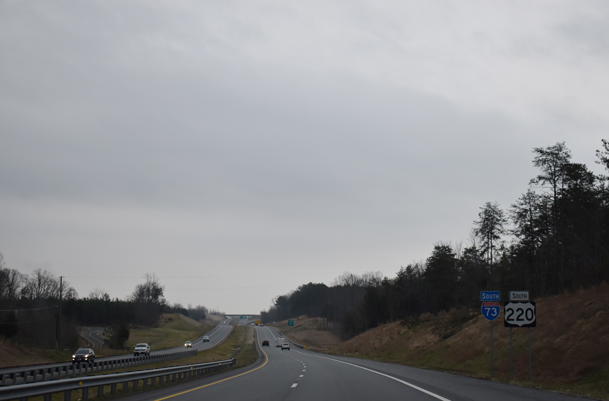
U.S. 220 north at the partially opened trumpet interchange with the Rockingham Bypass where I-73/74 begin. 08/14/21
A 3.7 mile extension of I-73/74 opened in June 2018 along U.S. 220 north from Harrington Road in Richmond County. The Federal Highway Administration (FHWA) approved a 2.91 mile addition of I-73/74 to the Interstate System on September 27, 2018. 08/14/21
Historic South End – Candor, North Carolina
I-73/74 previously concluded along U.S. 220 four miles south of Candor. Photo by Chris Patriarca (08/16/03).
U.S. 220 shifted from I-73/74 back onto its former alignment (U.S. 220 Alternate). U.S. 220 Alternate extends north through Candor, Biscoe, Star, Ether and Seagrove. Photo by Chris Patriarca (08/16/03).
The two lane section of U.S. 220 south to Norman was bypassed in January 2008 with the succeeding section of I-73/74 south beyond Ellerbe. Photo by Chris Patriarca (08/16/03).
Sources:
- “Activists vow fight if I-73 plans move farther south.” The Sun News (Myrtle Beach), July 19, 2003.
- “Citizens prioritize for NCDOT.” The Courier-Tribune, October 14, 2003.
- “Interstate corridor might go through Marion County.” Florence Morning News, October 2, 2003.
- “I-73 proposed as toll road.” John Lansford, post to MTR, December 16, 2003.
- “Interstate 73 backers look to other states” by Zane Wilson, The Myrtle Beach Sun News
- “Re: S.C.: Interstate 73 backers look to other states.” Sherman Cahal, post to MTR, Wednesday, April 13, 2005.
- “Short Road Has Wide Influence.” Sun News (Myrtle Beach, SC), May 4, 2001.
- “Veterans Highway Offers Some Relief (Conway Bypass Opens).” Sun News (Myrtle Beach, SC), June 30, 2000.
- “Part Of S.C. 22 Opening Monday.” Sun News (Myrtle Beach, SC), November 3, 2000.
- “New I-73 signs go up, but not the highway.” The Roanoke Times (VA), April 3, 2015.
- “New leg of I-73 in Triad to open this year.” Triad Business Journal, January 26, 2016.
- “Re: Interstate 73/74” online posting by bob7374, AARoads Forum, February 26, 2016.
- “I-73 project closer than it’s ever been to construction.” WMBF, May 25, 2016.
- “County supervisors told I-73 project appears to be over.” Martinsville Bulleton, May 24, 2016.
- “Re: I-73 in VA” online posting by Grzrd, AARoads Forum, May 26, 2016.
- “Governor Cooper Celebrates New Section of Interstate 73.” North Carolina Department of Transportation (NCDOT), news release. June 9, 2017.
- “Bryan Boulevard reopens following construction.” WGHP (High Point, NC), July 3, 2017.
- “Four New Projects for Division 8 in Updated Draft Transportation Plan.” North Carolina Department of Transportation (NCDOT), news release. June 29, 2017.
Page updated April 12, 2023.