Interstate Business Route 90

Business Loop I-90 and U.S. 14 travel together through Sundance, Wyoming. The two routes intersect WY 585 at the center of town. This view looks westbound along Cleveland Street at Sixth Street. 06/28/13
Transcontinental Interstate 90 has approximately 39 active off-Interstate business loops and spurs throughout the Northwest, Rocky Mountain and Great Plains states. There are no business routes posted east of Austin, Minnesota for the remainder of the 1,360 mile route of I-90 to Boston.
Idaho | Montana | Wyoming | South Dakota | Minnesota
Washington
Cle Elum

The former business loop through Cle Elum connected with I-90 from Exit 84 to Exit 85 via old U.S. 10 and Washington 903. As of June 1999, there was at least one Business Loop I-90 shield still posted in Cle Elum. It could not be found in August 2006.
Ellensburg

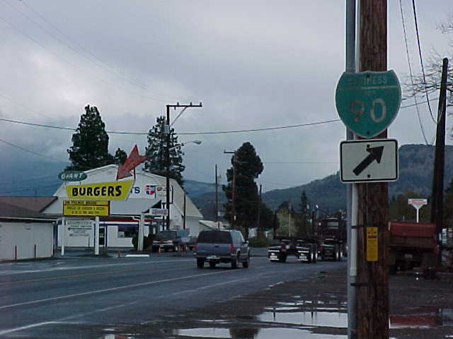
This business route forms a 5.2 mile loop from I-90 between Exits 106 and 109 along portions of old U.S. 10 and U.S. 97. Business Loop I-90 briefly overlaps with U.S. 97 east from a parclo interchange next to the Yakima River to Dolarway Road. U.S. 97 branches north from there while the business route stays east along University Way to Main Street and the Ellensburg street grid. Main Street takes the route south through the city center to Canyon Road. Canyon Road (former U.S. 97) expands the route into a five-lane commercial arterial with an array of motorist services (gas, food, lodging) to I-90.
This business loop was field-checked by Mark Bozanich in May 1999 to reveal signs throughout Ellensburg. Some of these remained as of June 2012. However, guide signs on the Interstate 90 main line omitted the route.
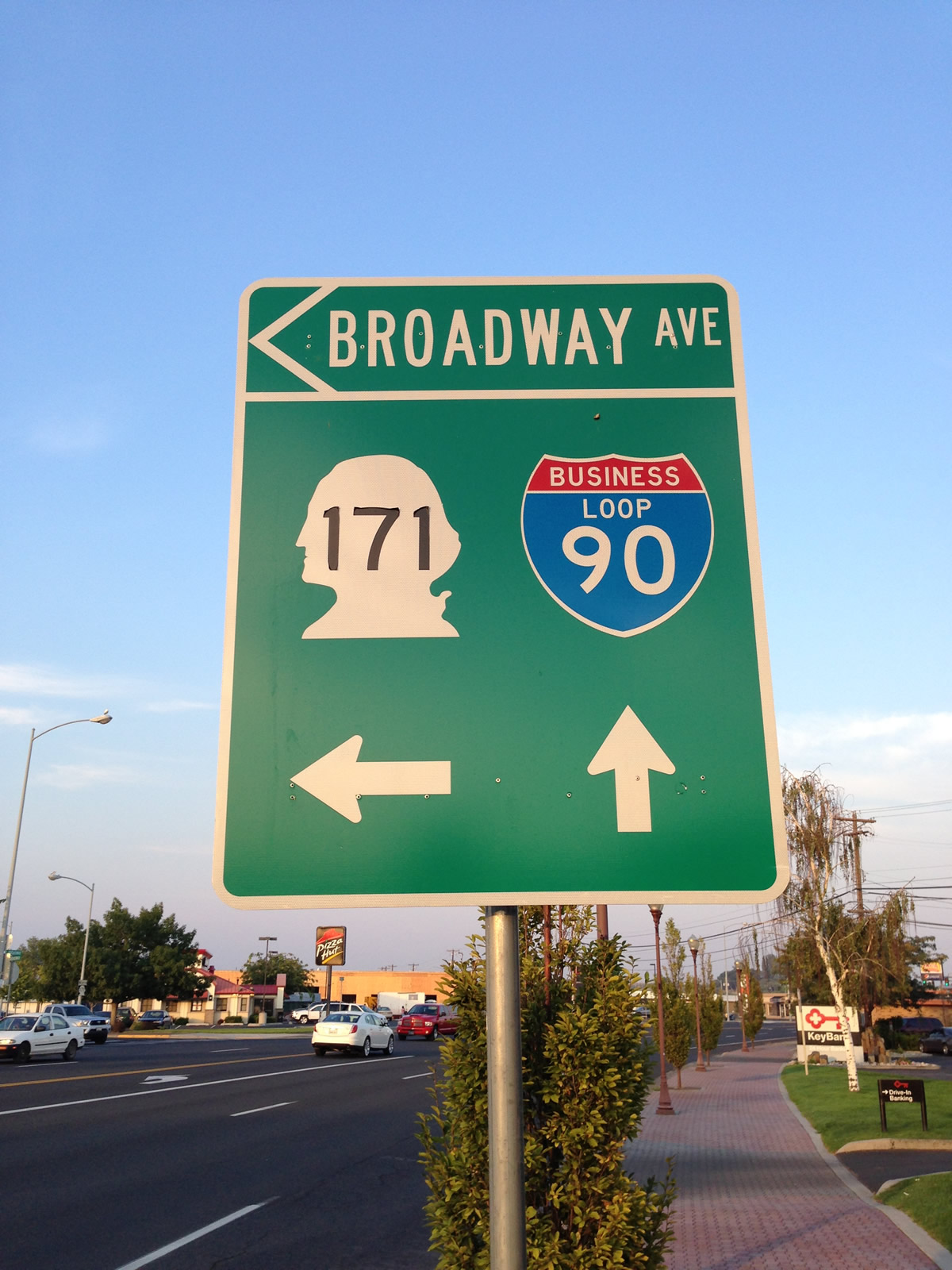
Moses Lake
Ritzville
This business loop served Ritzville north from I-90 between Exits 220 and 226 via old US 10-395. The 6.8-mile route followed west 1st Avenue northeast to the city center, and Danekas Road northeast from there to Schoessler Road and a return to I-90.
The Ritzville business loop was field-checked by Mark Bozanich in May 1999 and again in 2000. Signs remained within the Ritzville city limits at that time, but are none were posted by 2006.
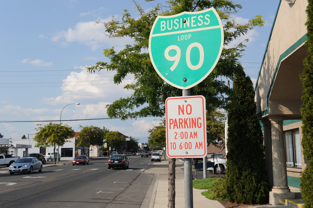
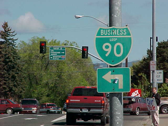
Spokane
Business Loop I-90 in Spokane followed a ten-mile course from Exit 276 to Exit 285 along portions of old U.S. 10. Portions of old U.S. 2, U.S. 195, and U.S. 395 ran concurrent with parts of old U.S. 10 in the Spokane area.
The Spokane Business Loop varied in signing by the early 2000s. Mark Bozanich added:
Entering Spokane from the west, Business Loop I-90 is posted from both I-90/U.S. 395 and U.S. 2. From the east, the traditional business route is posted at the Interstate 90 exit as the Sprague Avenue Business Route. Spokane County not only does not do a good job of posting Business Loop 90 signs along East Sprague Ave, it also avoids posting trailblazer signs to Interstate 90 from those north-south arterials that cross Sprague and [the] interchange with Interstate 90.
A visit to Spokane in 2006 revealed no signing for Business Loop I-90 along the mainline in the city center. The only signs remaining for this business loop are posted at the interchange between U.S. 2 and Sunset Highway, northeast of Spokane International Airport (GEG).
Spokane Valley
AASHTO approved this non-state maintained business loop on May 5, 2013. Continuing along portions of historic U.S. 10 east from the former Spokane business route, the Spokane Valley Business Loop for I-90 extends east from Exit 285. Business Loop I-90 travels along the Valley Couplet of Appleway Boulevard east and Sprague Avenue west between I-90 and University Road. The Valley Couplet was completed in 2000. Construction converted East Sprague Avenue from two-way traffic into a four-lane westbound roadway, complementing the new four-lane eastbound Appleway Boulevard.
East from University Road, Business Loop I-90 carries two-way traffic along East Sprague Avenue, the former alignment of U.S. 10, before returning to I-90 by way of Appleway Avenue east to Barker Road north. The route is approximately 8.21 miles long. It ends at Exit 293.
Business Loop I-90 guide signs are posted on both I-90 east at Exit 285 and I-90 west at Exit 293 for the Spokane Valley business route as of 2015.
Idaho
Post Falls
Business Loop I-90 in Post Falls starts at Exit 5 (Spokane Street) and heads north to old U.S. 10 (Seltice Way). Following old Seltice Way east, the 1.114-mile loop returns to I-90 at a half-diamond interchange (Exit 6).1
Signs are posted at the turns of Business Loop I-90 in Post Falls and at the ramp ends from Interstate 90 as of 2015.
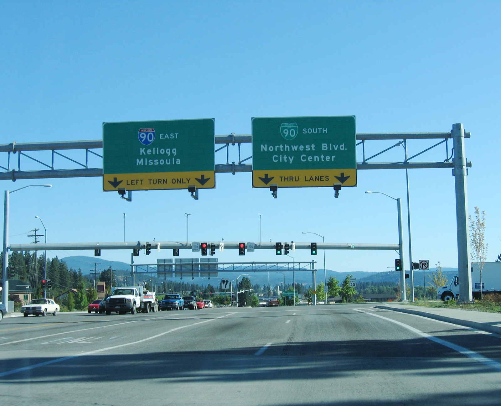
Coeur d’Alene

Business Loop I-90 followed the course of old U.S. 10 for 3.8 miles between Exits 11 and 15. The route followed Northwest Boulevard south to the city center and Sherman Avenue east back to I-90. Two segments remain state maintained as of 2016. These include a 0.116 mile section of Northwest Boulevard within the diamond interchange at Exit 11 and what the ITD Milepoint Log labels as the 0.147 mile long I-90 Spur between 23rd Street / Coeur d’ Alene Lake Drive and the east side ramps with I-90 at Exit 15.1
All signed references to the Business Loop were removed by August 2012. This included green outs over signs posted at Northwest Boulevard.
Back in 1989, when Interstate 90 along the northern edge of Lake Coeur d’Alene was incomplete, the business loop designation continued even further east beyond Exit 15 along what is now Coeur d’Alene Lake Drive (former U.S. 10). Coeur d’Alene Lake Drive provided a temporary routing for I-90 pending completion of the freeway. Today, this segment is a 5.5-mile long scenic drive that culminates at a dead-end in the shadow of the freeway. It was still maintained by the state as of October 2013.2,3
Kellogg
The Kellogg Business Loop was dropped from the ITD Milepost log by 2006. Shields were removed from guide signs on I-90 and replacement signs installed by 2012 omitted the space previously allocated for the business route.
The route followed Cameron Avenue (old U.S. 10) from Exit 49 with Bunker Avenue southeast to Exit 51 at Division Street. As of 2012, shield assemblies remain at Hill Street and near Cedar Street.
Osburn
What was originally Business Loop I-90 connecting Osburn with Silverton was split into separate state-maintained Business Spurs by 2013. The Osburn Business Spur travels 1.52 miles from Exit 57 south along Third Street to Mullan Avenue (former U.S. 10). Business Spur I-90 follows Mullan Avenue east to Silver Valley Road, concluding at the Osburn city line.1 The loop used to continue beyond this point on Silver Valley Road into unincorporated Silverton. It may remain signed as a full loop despite the middle portion no longer being maintained by the state.
Silverton
The Silverton business spur links the diamond interchange (Exit 60) at Silverton with Silver Valley Road (old Business Loop I-90) to the south and Yellowstone Avenue to the north. The spur travels 0.119 miles along Markwell Avenue.1
Business Spur I-90 at Silverton represents the eastern extent of the former I-90 Business Loop leading back to Osburn. A 1.1 mile gap separates the two along Silver Valley Road (old U.S. 10) as it parallels the Coeur d’s Alene River South Fork.
Wallace
The Wallace business loop travels 1.243 miles through Wallace along portions of old U.S. 10. Beginning at Exit 61, Business Loop I-90 connects I-90 with Front Street (Harry F. Magnuson Way) via North Frontage Road. The route follows Front Street east along the South Fork of the Coeur d’Alene River to 5th Street and the Wallace street grid. 5th Street south to Bank Street east returns the route to I-90 at Exit 62.
Until September 12, 1991, the business loop represented the Interstate 90 mainline through the city of Wallace. The 1970 plan for I-90 took the freeway through the historic town, but efforts made by 1976 added most of Wallace to the National Historic Register. This lead to a shift of the freeway to bypass the community, which it does on a viaduct north along side the Coeur d’Alene River South Fork. A quote from Idaho Transportation Department (ITD) states: “To avoid complications from having the interstate pass through the heart of Wallace as originally planned, residents added the city to the National Register of Historic Places in 1976. As a result, I-90 was routed away from town through a narrow mountain corridor by constructing a viaduct. U.S. 10 became Business Loop I-90, and the business loop was the defacto route for the interstate through the mid to late 1980s while the bypass was constructed. The I-90 bypass opened to traffic in 1991, and the traffic signal was retired a short time thereafter. That traffic signal later was returned to service on a Wallace intersection and remains functioning today.”4
On May 8, 2010, the Wallace business loop was renamed “Harry F. Magnuson Way” in honor of Harry Magnuson, who was instrumental in seeing Interstate 90 bypassed around Wallace rather than through it. Mr. Magnuson sued the Idaho Transportation Department in 1970, claiming that the route of Interstate 90 through the city would have violated the federal Environmental Protection Act of 1970 by not conducting an environmental impact study. After years of lawsuits to 1976, the final alignment was recommended to take Interstate 90 north of Wallace and avoid its historic downtown.5
Mullan
The Mullan Business Loop follows River Street (former U.S. 10) and Friday Avenue east from a wye interchange (Exit 68) with Interstate 90 east to the Atlas Road interchange (Exit 69) through the historic downtown area. The route tallies 1.00 mile.1
Montana
Alberton
This business route follows Montana Secondary 507 (old U.S. 10) through Alberton between Exits 75 and 77 via Railroad Street and Adams Street.
Missoula
This business route begins at Exit 101 and turns south alongside U.S. 93 (Reserve Street) to a folded diamond interchange with Broadway Street (old U.S. 10). U.S. 93 remains south on Reserve Street to U.S. 12, while Business Loop I-90 turns southeast along Broadway Street to the Missoula city center and the University of Montana via U.S. 12 (Madison Street Bridge) west. A five block section of the route doubles as Business U.S. 12 between Higgins Avenue and Madison Street. U.S. 12 joins Business Loop I-90 east from there to Van Buren Street, where the two turn north to meet Interstate 90 at Exit 105.
The route is well signed as of 2016, with an array of traveler services and lodging lining the Reserve Street leg.
Deer Lodge
Business Loop I-90 serves Deer Lodge along a 3.5 mile route between Exits 184 and 187. The loop doubles as unsigned Montana Secondary Highway 275 along Main Street, which is also old U.S. 10. Deer Lodge provides several lodging options for travelers and is a tourist destination with points of interest including the Old Prison Museums, Montana Auto Museum and Frontier Montana Museum.
One final business loop on the day. 1996 date sticker on the back. Lone shield for the route.
Posted by AARoads on Monday, August 8, 2016
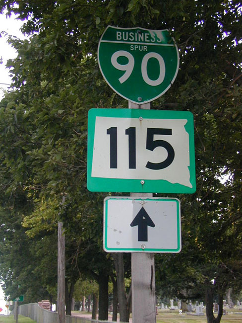
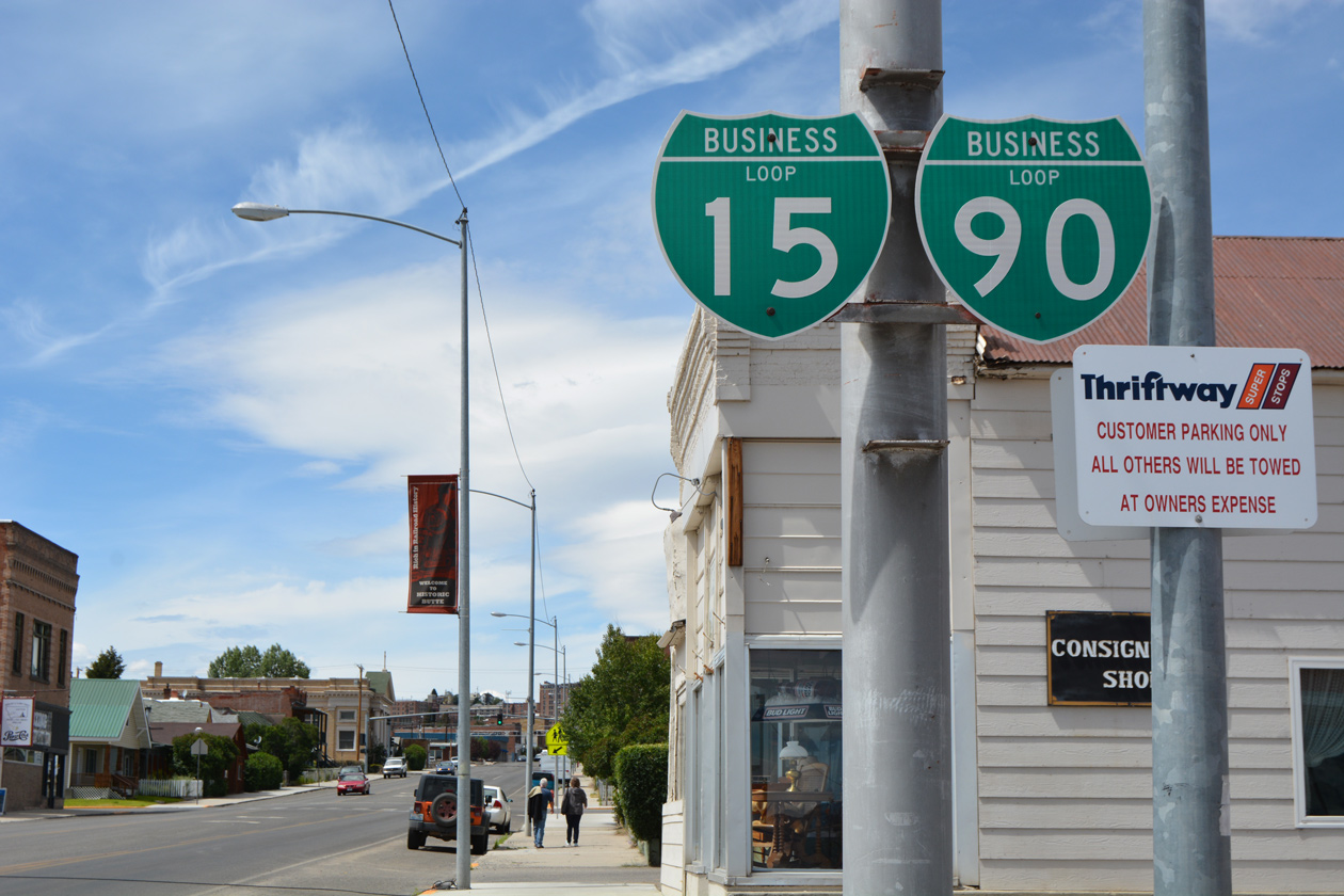
Butte
The Butte business loop follows the route of Interstate 115 and old U.S. 10-91 to Downtown Butte along a series of five streets. Cosigned with Business Loop I-15 for its entirely, the 5.5 mile route forms an Omega-shaped arc between Exits 124 and 127 along I-15/90. The route is fairly well posted as it extends east from I-115 along Iron Street to Montana Street north and Park Street east to the city center. Arizona Avenue turns the pair south to a seamless transition onto Utah Avenue South to a T-intersection with Front Street. Front Street curves the routes southeast below a Union Pacific Railroad bridge to Harrison Avenue, a four and five-lane commercial boulevard. Harrison Avenue returns the loops to I-15/90 at a parclo interchange, opposite the north end of MT 2 and Butte Plaza Mall.
Good morning from Butte, Montana!
Posted by AARoads on Tuesday, August 9, 2016
Bozeman
Forming a 3.3-mile L-shaped route, Business Loop I-90 joins I-90 with the Bozeman city center between Exits 306 and 309. Seventh Avenue leads the route south along a commercial arterial into the Bozeman street grid, where the loop turns east along side U.S. 191 on Main Street (old U.S. 10). Main Street bisects Downtown northeast of Montana State University to Lindley Park while U.S. 191 south provides a gateway to Yellowstone National Park. Eastern reaches of Main Street expand into a commercial arterial leading into the parclo interchange with Interstate 90 opposite old U.S. 10 and 191. A 2016 drive along the loop yielded sporadic signing of the business route.
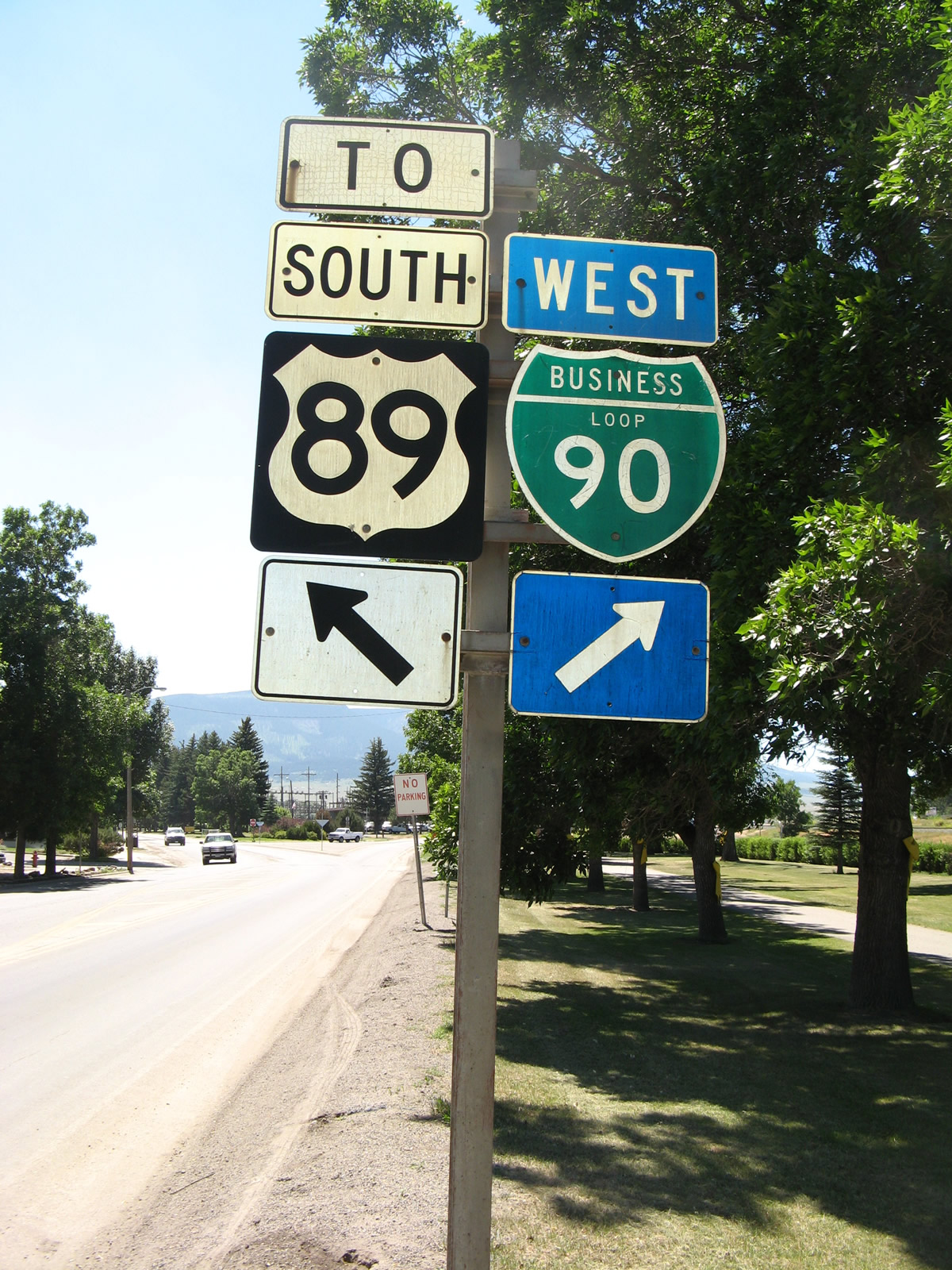
Livingston
Interstate 90 & U.S. 191 bypass the city of Livingston to the south while Business Loop I-90 connects the freeway with the city center via a 6.7-mile route. The route begins at Exit 330 and quickly overtakes Highway 10 West, east into the city. Park Street (old U.S. 10 and 89) extends Business Loop I-90 through the business district to the Yellowstone River, where the route becomes rural ahead of the east end at Exit 337. U.S. 89 ties into I-90 at Exit 333 from Yellowstone National Park to the south. The route north to Business Loop I-90 is unnumbered.
Big Timber
Business Loop I-90 at Big Timber arcs 4.2 miles north from Exits 367 and 370 of Interstate 90. The western half of the route doubles as U.S. 191 along 1st Avenue (old U.S. 10), while the eastern section takes Big Timber Loop Road across the Boulder River back to I-90. One shield per direction was noted on a 2016 visit to the city.
Laurel
This business route follows Main Street (old U.S. 10) east through Laurel from an access road linking it with I-90 at Exit 433 to Exit 437 east of the city line. Totaling 5.0 miles, Business Loop I-90 once intersected the north end of U.S. 310 at 1st Avenue in Downtown Laurel. The US route was truncated to its interchange (Exit 434) with I-90 and U.S. 212 just to the south by 2008. Several shields were observed along Main Street for the business route in 2016.
Billings
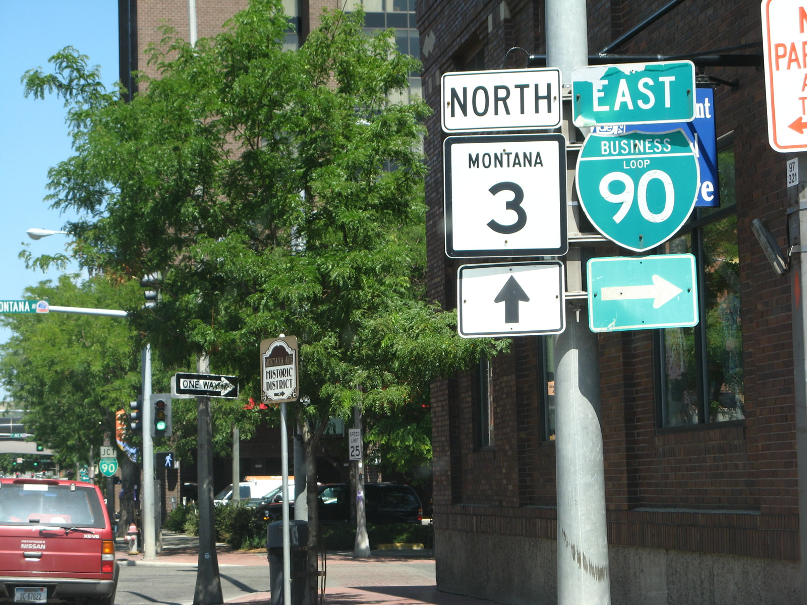
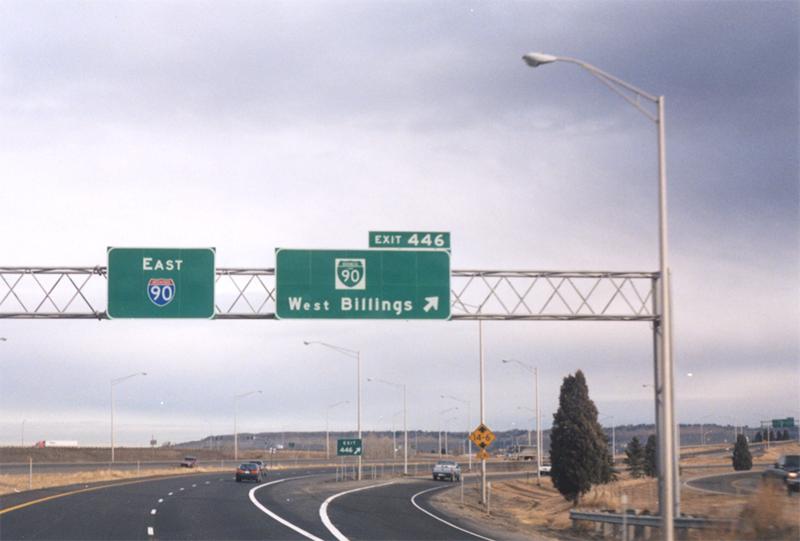
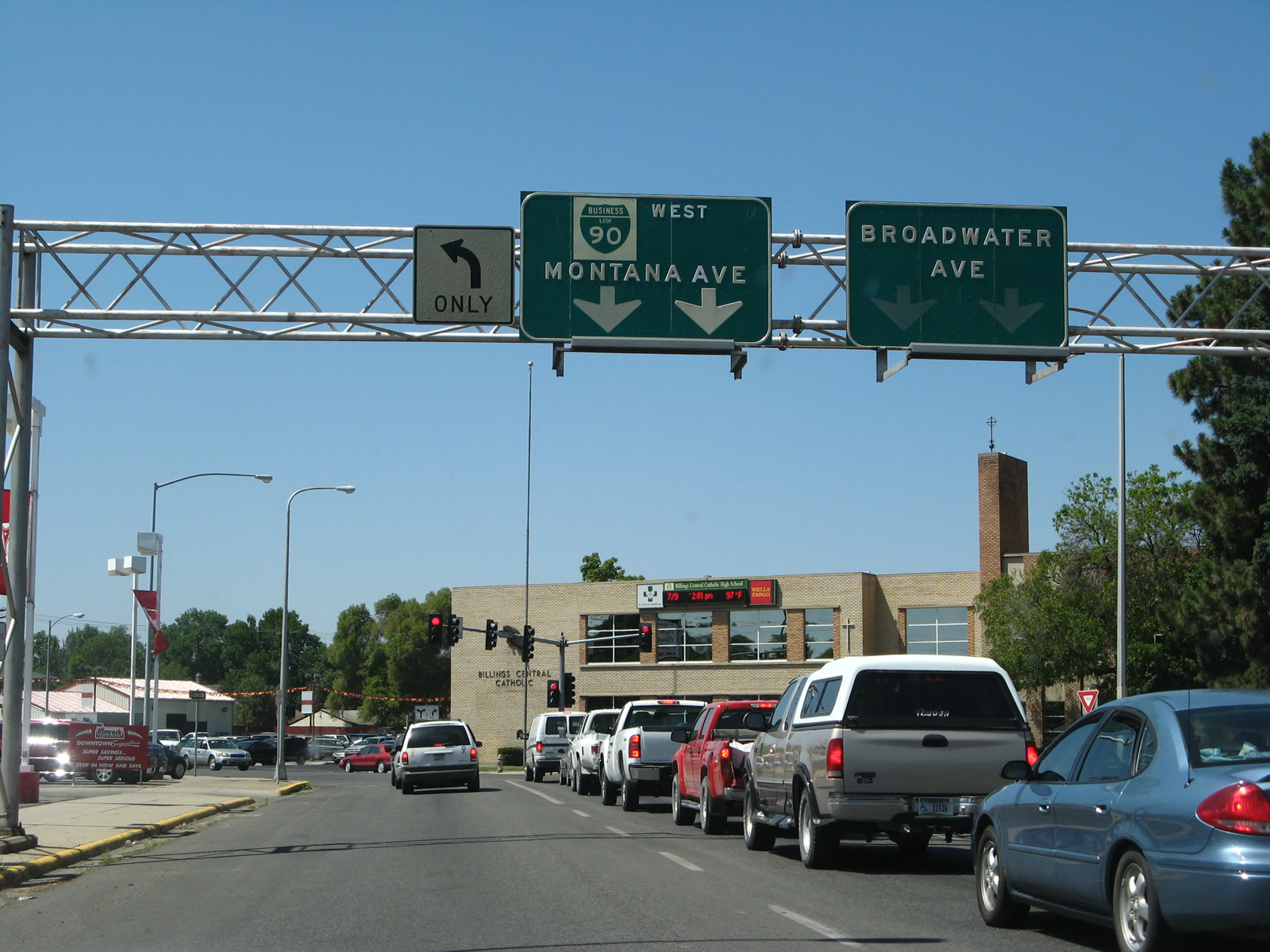
Comprising a multi-lane route for 7.0 miles, the Billings business loop angles northeast from an interchange complex (Exit 446) linking Interstate 90 with Mullowney Lane and Laurel Avenue. The route parallels Montana Rail Link (MRL) lines to a viaduct carrying traffic over the railroad and onto Montana Avenue. Business Loop I-90 runs along the north side of the MRL yard to Division Street, where it separates into a couplet using Montana Avenue east and 1st Avenue North west. The one-way pair intersect Montana 3 (27th Street) at Downtown Billings. The state highway leads northwest to Montana State University Billings and Billings Logan International Airport (BIL).
Remaining along old U.S. 10, the couplet of Business Loop I-90 recombines at North 18th Street along a five-lane section of 1st Avenue North. U.S. 87 ties into the route just west of the Yellowstone River, with the two highways spanning the river east to Interstate 90 at Exit 452. Traveler services cluster around the east and west ends of the route, while the central portion serves interests to Downtown. The business route remains well signed as of August 2016.
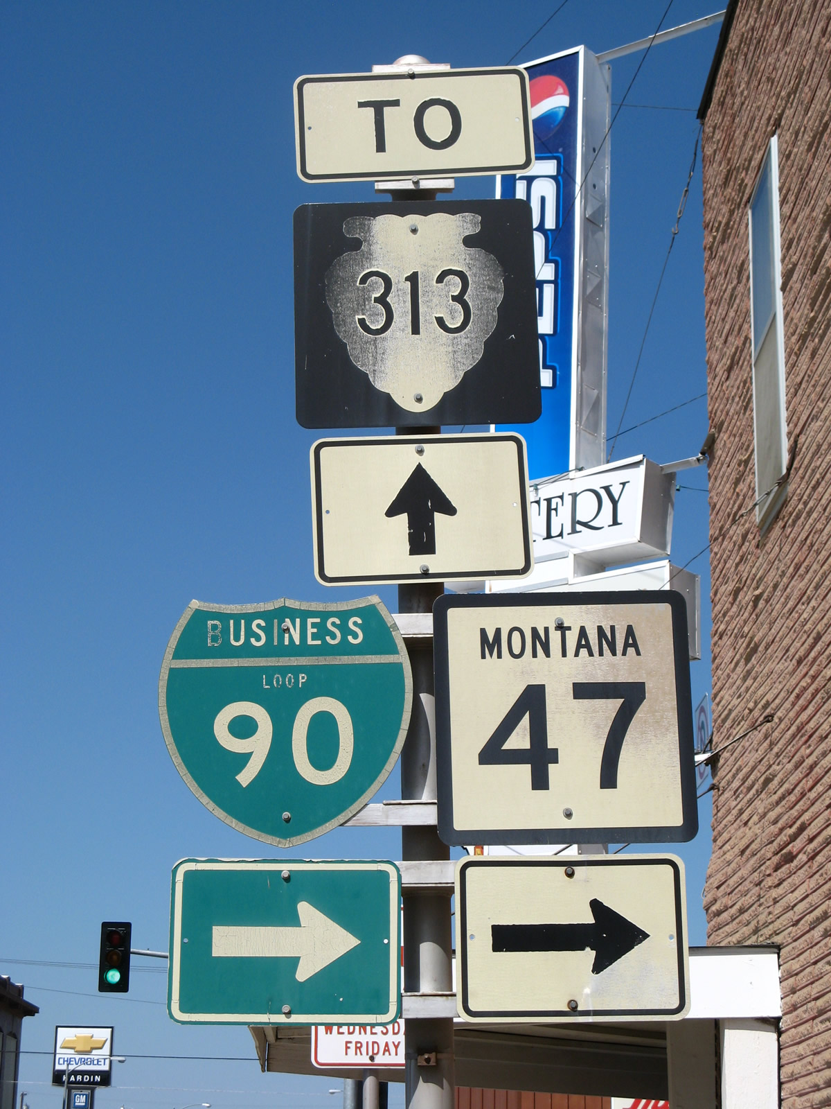
Hardin
Business Loop I-90 forms a 2.9 mile arc south from I-90 through the city of Hardin. The route overlays portions of MT 47 and old U.S. 87-212 along a combination of Crawford Avenue, 14th Street West, Center Avenue and Third Street East between Exits 495 and 497. The route is well marked in both directions.
Business Loop I-90 east & #Montana 47 south in Hardin. #roads pic.twitter.com/wDjzEasWWQ
— AARoads (@AARoads) August 8, 2016
Wyoming
Sheridan
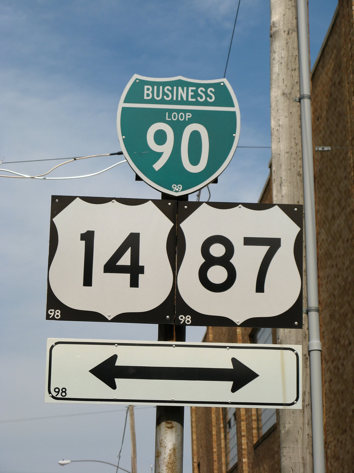
Sheridan represents the main service center along Interstate 90 between Billings and Buffalo, in addition to a tourism hub for visitors to the Big Horn Mountains. A 4.8 mile long business loop serves the city between Exits 20 and 25. Business Loop I-90 branches south from a trumpet interchange with I-90 along Main Street to the city center. The route returns to I-90 via Coffeen Avenue southeast and Brundage Lane via U.S. 14. Following standard Wyoming practice, the business route is also signed as Business U.S. 14-87.
Northbound (westbound) Business Loop I-90 and US 14-87 in Sheridan, Wyoming on Coffeen Avenue. pic.twitter.com/wE8XbtZeK7
— AARoads (@AARoads) May 11, 2015
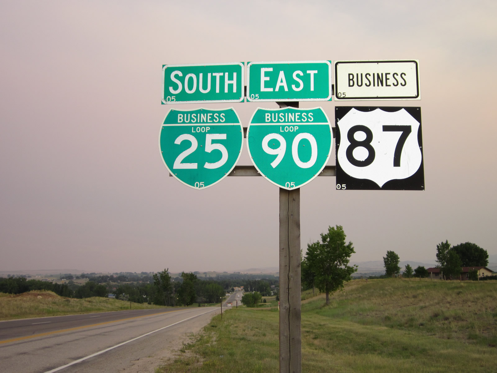
Buffalo
The 3.9 mile business loop for I-90 in Buffalo forms an L-shaped route between Exits 56A and 58. The route is cosigned with Business Loop I-25/U.S. 87 Business along north-south Main Street and with U.S. 16 along east-west Hart Street. Business Loop I-25/U.S. 87 Business follow Main Street south through the city center to I-25 while U.S. 16 branches west from the pair to Worland. All motorist services are available along the Hart Street segment between Main Street and the diamond interchange (Exit 299) with Interstate 25.Both routes are well signed, with business route signs posted en route to the city center and trailblazers for I-25 and/or I-90 leading away from the business district.
Saw BL I-15 & 84 last month and here's another Interstate Business Loop tandem.
Posted by AARoads on Sunday, August 7, 2016
Gillette
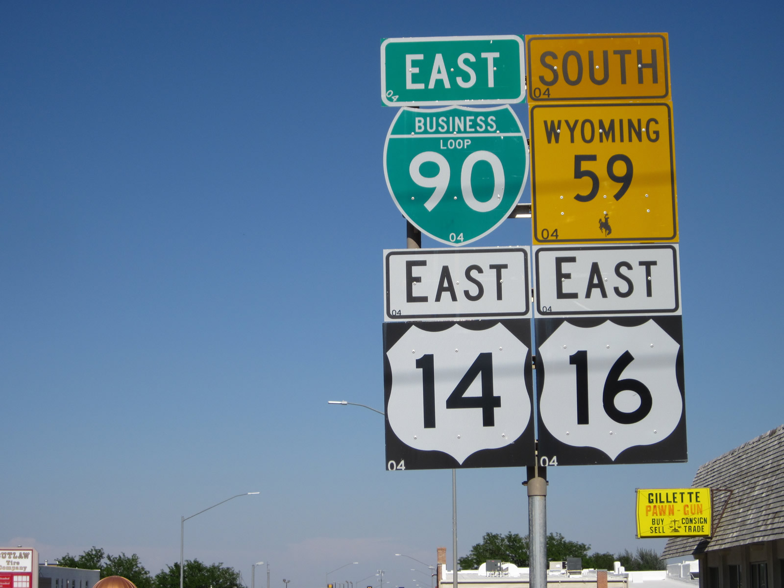
Interstate 90 arcs across Gillette while a business loop connects the freeway with Downtown along Second Street. The 3.9-mile route runs between Exit 124 at Skyline Drive (Wyoming 50) and Exit 128. With the exception of a very short segment at the western end along WY 50, this business route is also signed in part as U.S. 14, U.S. 16 and Wyoming 59.
With the development of Gillette into one of the largest cities in northern Wyoming, several motorist services are found along Wyoming 59 (Douglas Highway) via Interstate 90 at Exit 126 rather than along the business loop. Guide signs along I-90 eastbound at Exit 128 omits all signed routes and instead displays “Port of Entry”.
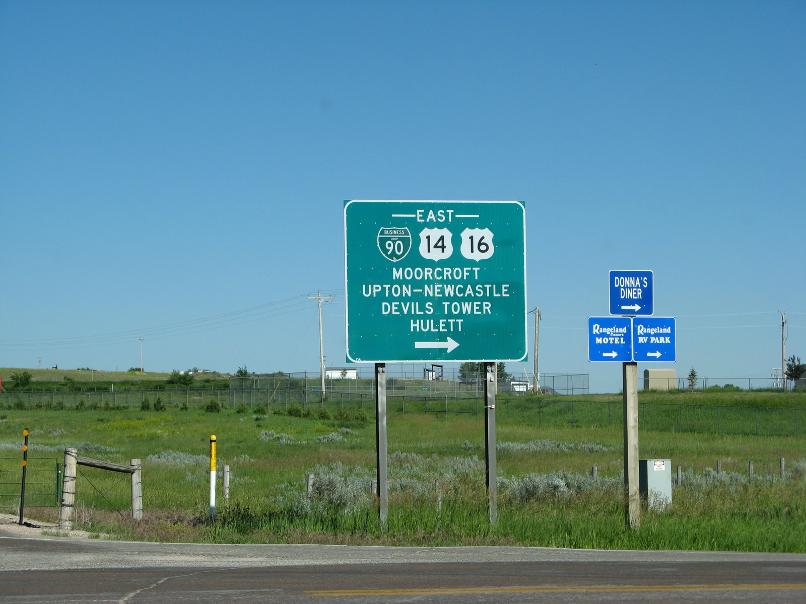
Moorcroft
Traveling 1.9 miles, Business Loop I-90 follows U.S. 14/16 through Moorcroft via Converse Street. Per a visit in July 2008, the loop is not signed from either direction on the freeway mainline, but shields are present along the loop itself. This remains the case of August 2016.
This kind of error happens in Wyoming from time to time. Business 90 is shown as I-90 on this recently replaced shield….
Posted by AARoads on Tuesday, August 9, 2016
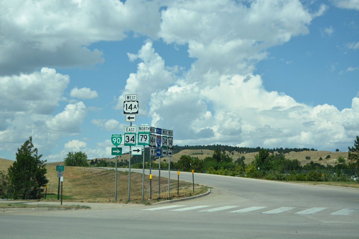
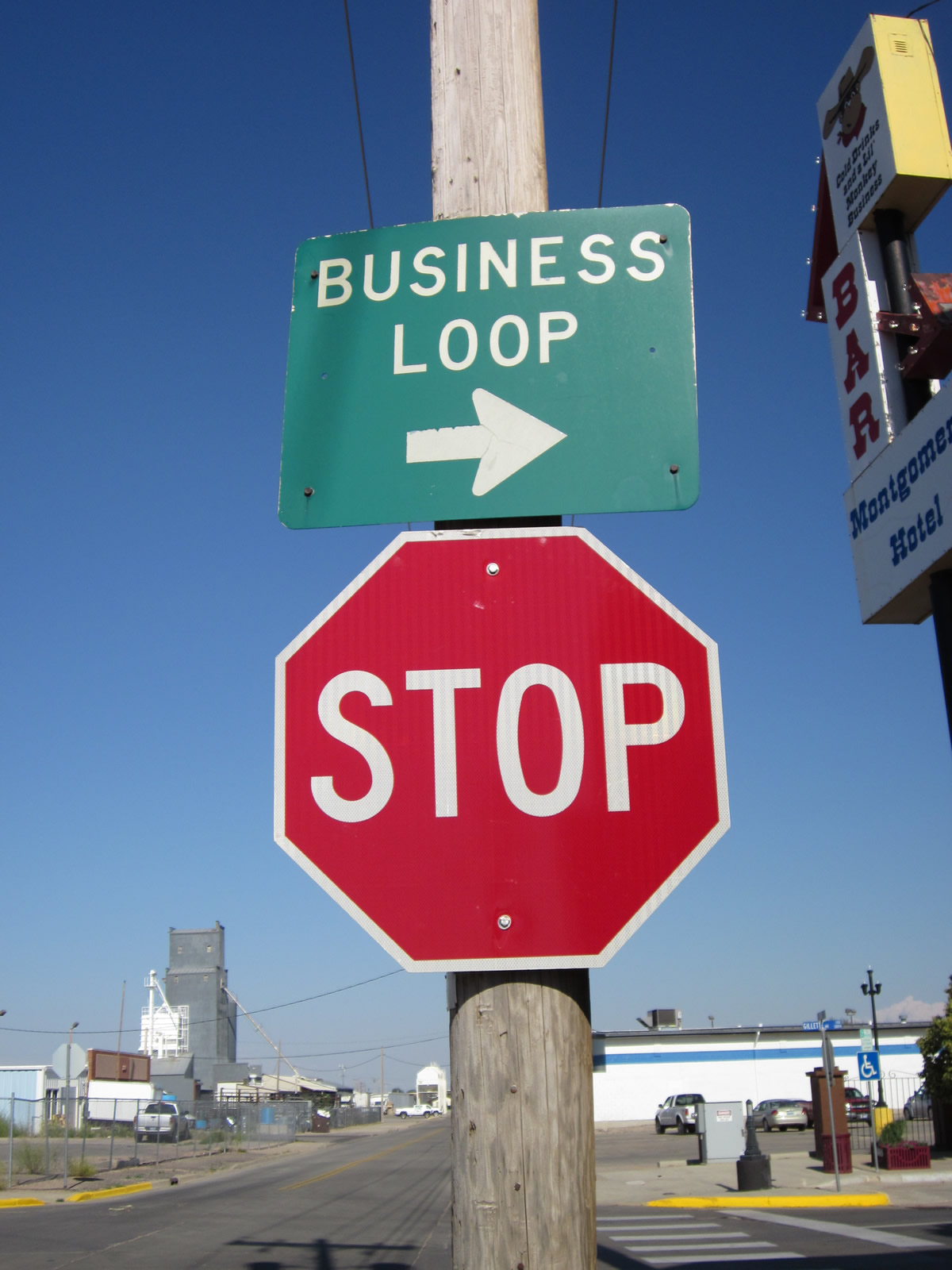
Sundance
Cosigned with U.S. 14 for its entire length, the Sundance business route intertwines with I-90 between Exits 185 and 191 via West and Cleveland Streets. The east end of the loop utilizes an access road between Old U.S. 14 and the Sundance Port of Entry.
South Dakota
Spearfish
The Spearfish business loop for I-90 begins at Exit 10 opposite U.S. 85 north to Belle Fourche. The 5.2 mile route follows North Avenue through North Spearfish and Main Street along the old alignment of U.S. 14 and 85 to the Spearfish city center. Turning east along Colorado Boulevard, U.S. 14A accompanies the business loop as it reconnects with the freeway at Exit 14. The route is referenced from the I-90 mainline and somewhat signed across the city.
A $28 million project redesigns the diamond interchange at the east end into a single point urban interchange. The project runs through June 1, 2018.
Sturgis
Business Loop I-90 serves Sturgis, and its annual bike rally, along a 3.3-mile route between Exits 30 and 32. The east-west portion doubles as South Dakota 34 & 79 (and old U.S. 14) to the city center, while the north-south component is locally maintained. Per a 2016 drive through the city, Business Loop I-90 is marked in both directions.
Rapid City
The longest Business Route for I-90, the Rapid City area route loops south from Exit 52 at Blackhawk to Exit 60 by Rushmore Crossing shopping center. Traveling 11.8 miles overall, Business Loop I-90 begins at the diamond interchange with Peaceful Pines Road, which it takes west to Sturgis Road (old U.S. 14/SD 79). This configuration replaced a direct off-ramp to Sturgis Road when I-90 was realigned at Blackhawk by 2009.
The Sturgis Road alignment south to Chicago Street in west Rapid City is state maintained and designated SD 231. The route is unmarked otherwise as it forms part of a truck route with SD 445 to SD 44 on Omaha Street. Business Loop I-90 parallels these routes to the south along locally maintained Main Street to SD 44 and Baken Park Shopping Center. The commercial arterial advances east to split into a couplet using St. Joseph Street (east) and Main Street (west) through Downtown Rapid City.
The one-way pair of Business Loop I-90 combines along East Boulevard as the route turns north to intersect SD 44 (Omaha Street) again and cross Rapid Creek. Arcing east, North Street comprises a four to five lane commercial boulevard carrying the business route back toward I-90. The loop concludes at a single point urban interchange in a growing retail area.
Possibly relating to the fact that the majority of the route is no longer state-maintained, many commercial mapping companies dropped Business Loop I-90 references from their Rapid City insets in the late 1990s. The loop however remained signed in the field as verified in September 2004, August 2014 and August 2016.
2008-09 work realigned I-90 at Black Hawk #SouthDakota to improve a substandard curve. Included was a new BL-90 exit pic.twitter.com/78p2ShYdeR
— AARoads (@AARoads) August 12, 2016
Wall
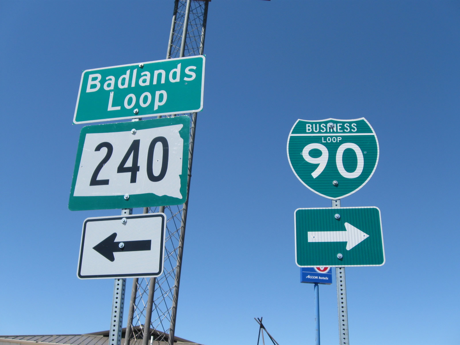
Business Loop I-90 at Wall travels 1.8 miles between diamond interchanges at Exits 109 and 110 within the town. The route bypasses the city center and the regionally famous Wall Drug Store in favor of a surface route bypass along South Boulevard, from Airport Road (old U.S. 14/16) to Glenn Street. Glenn Street returns the route to I-90/U.S. 14, opposite the beginning of South Dakota 240, the Badlands Loop to Badlands National Park.
The Wall #SouthDakota Business Loop for I-90 bypasses the business district and instead serves a school & just a handful of services #roads
— AARoads (@AARoads) August 12, 2016
Kadoka
Business Loop I-90 in Kadoka begins at Exit 150 and follows SD 73 south to SD 248 (Highway 16) east through the city business district. The 2.9 mile route concludes via South Creek Road north to Interstate 90 at Exit 152. SD Hwy 248 is not shielded and instead signed as the formal street name.
The Kadoka Business Loop for I-90 is alive and well. Serves a number of motels and is well signed. #SouthDakota #roads
— AARoads (@AARoads) August 12, 2016
Belvidere
The 1.1 mile business spur departed Interstate 90 at Exit 163 and followed SD 63 (Main Street) south into the rural town of Belvidere. The business spur signs were removed as of 2009.
A lone service station was in operation on Main Street at I-90 in August 2016. It appeared the remaining businesses in the community of 63, including a post office, were shuttered.
Murdo
This business loop serves the city of Murdo along a 2.3 mile route from Exit 191 with SD Hwy 248 to Exit 192 with U.S. 83. The route follows Fifth Street (old U.S. 16) east to Kennedy Avenue south, with most services located toward or at the east end. Where Business Loop I-90 east ends, U.S. 83 north combined with I-90 from Valentine for 20 miles toward Vivian.
Murdo #SouthDakota Business Loop I-90.
Short loop with several motels. Decently signed. #roads pic.twitter.com/tHItIQvmd0— AARoads (@AARoads) August 12, 2016
Vivian
This 3.6 mile long business loop served Vivian between Exits 212 and 214 via U.S. 83 north, SD Hwy 248 (Old U.S. 16) east, and 293rd Avenue south. No signs for the business loop were posted in 2009, and as of 2016, just one service station was located along the former route.
Presho
The Business Loop for I-90 at Presho follows a portion of SD Hwy 248 (old U.S. 16) east from 305th Avenue to Willow Street. Only 2.0 miles in length, the business route connects with I-90 via rural diamond interchanges at Exits 225 and 226.
The Presho Business Loop for I-90 ties into the north end of US 183. US 183 runs south 1,250 miles to Refugio, TX.
Posted by AARoads on Friday, August 12, 2016
Oacoma and Chamberlain
This 7.4 mile route of Business Loop I-90 begins at Exit 260 and Dougan Avenue at the town of Oacoma. Overtaking Highway 16 parallel to the freeway, the business route passes by a number of services including Al’s Oasis en route to the American Legion Memorial (Chamberlain-Oacoma) Bridge across Lake Francis Case of the Missouri River. East into Brule County, Business Loop I-90 enters the Chamberlain city center with it combines with South Dakota 50 along King Street. The pair curve southward and expand into a four-lane boulevard to Sorensen Drive. The route ends south of there as SD 50 east commences a 6.7 mile overlap with Interstate 90 east from Exit 265.
The Chamberlain-Oacoma Bridge opened to traffic on September 25, 1925. Due to the construction of the Fort Randall Dam, the span was relocated and expanded in 1953 to accommodate the creation of Lake Francis Case. Dedicated on December 7, 1953, the bridge has five through truss spans in each direction, connected to the west banks of the Missouri by a long causeway. The crossing was added to National Register of Historic Places in 1995 and refurbished in 2011-12.
White Lake
Designated as Business Spur I-90P but not signed in the field, the 0.513 mile route followed 374th Avenue north from Exit 296 to Old Highway 16 at Main Street in the rural city of White Lake. The route is no longer listed in the South Dakota Codified Laws for the State Trunk Highway System.
Plankinton
The former business route for I-90 at the city of Plankinton looped north from Exits 308 and 310. The western 2.552 miles of the route, consisting of Main Street north and Davenport Street (historic U.S. 16) east double as SD 258. SD 258 is an unsigned municipal and state secondary highway.
The eastern leg of the route follows U.S. 281 between Old Highway 16 and Interstate 90 for 1.3 miles. Signs for the Plankinton business loop were removed by 2009 and South Dakota 258 remains unposted as of 2016.
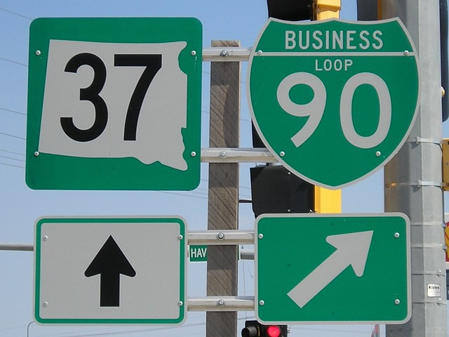
Mitchell
The state maintained business route for I-90 through Mitchell begins at Exit 330 and ends at Exit 332. The loop initially runs along side South Dakota 37 (Ohlman Street) north to Havens Street (old U.S. 16). Havens Street crosses the Mitchell street grid east as a five lane boulevard to Sanburn Boulevard, south of the city center. The 1.426 mile segment on Havens Street leads Business Loop I-90 east to South Dakota 37 and 38 at Burr Street. Burr Street takes the loop southeast along side SD 37 to a commercialized diamond interchange with I-90 while SD 38 lines the next 12 mile segment of old U.S. 16 east toward Alexandria.
The famous Corn Palace, a converted municipal gymnasium located at the intersection of Main Street and Fifth Avenue, is located a mile north of the business loop in Downtown Mitchell. The Business Loop is well signed, with a trailblazer posted at Havens and Sanborn Boulevard as well.
Sioux Falls
Uniquely signed as “Downtown Spur” I-90, the Sioux Falls business spur extends south from Exit 399 to the city center along a 5.1 mile course. Cosigned with South Dakota 115, the route utilizes portions of old U.S. 77 along a route using Cliff Avenue, Benson Road and Minnesota Avenue. Business Spur I-90 south ends at the one-way couplet of 10th Street and 11th Streets in Downtown Sioux Falls, where Business Spur I-29 ends from the west and Business Loop I-229 makes a 90 degree turn from Minnesota Avenue (SD 115) onto the couplet of 10th & 11th Streets. The northbound direction of the business spur is generally signed with trailblazers for Interstate 90 in lieu of business route markers.
According to Brad Schwartze, in 2006 SD 42 and SD 115, along with the cosigned Business Loops/Spurs for I-29, I-90 and I-229, within the city of Sioux Falls were turned over to the municipality for maintenance. South Dakota DOT’s Transportation Inventory Management group indicated that these actions occurred so that the city could overtake traffic management along the respective routes. The state and business spur designations remained signed, although with less attention under city maintenance.
The old alignment of U.S. 77 through Sioux Falls took Minnesota Avenue (SD 115) to North Drive, which it followed northeast to Cliff Avenue. This changed when the eastern most section of North Drive permanently closed, severing the connection with Cliff Avenue.
Remaining Downtown Spur I-90 shield on Cliff Avenue.
Posted by AARoads on Saturday, August 6, 2016
Minnesota
Worthington
Traveling 3.2 miles, this business loop begins at Exit 42 and ends at Exit 45. Diagonal Road (CR 25 / former MN 266) takes the route southeast to Oxford Street. Oxford Street, the historic alignment of U.S. 16, extends east to the Worthington city center, where it combines with U.S. 59 from Humiston Avenue to a roundabout with Minnesota 60. MN 60 (Oxford Street) returns the route to I-90 by a pair of truck stops and an industrial plant.
Fairmont
Forming a U-shaped route south from Interstate 90 for 6.1 miles, this business loop begins at Exit 99 and ends at Exit 102. Bixby Road and 190th Avenue lead the route south along side CR 39 to the Martin County Fairgrounds and Lake Avenue (CR 26). Lake Avenue, the former alignment of U.S. 16, continues the business route east to the city center and one block section on Main Street. Blue Earth Avenue crosses the Fairmont street grid east to Minnesota 15 (State Street). A commercial arterial, MN 15 leads due Business Loop I-90 due north to a folded diamond interchange with Interstate 90.
Small guide signs direct Business Loop I-90 between Downtown Fairmont and Minnesota 15.
Austin
Business Loop I-90 through the city of Austin follows a 4.2 mile route to the south of Interstate 90 along old U.S. 16. Beginning at Exit 175 on the west side of Austin, the route combines with MN 105 along Oakland Avenue from Mower County 46 east to 12th Street NW/SW. There the route separates into a couplet (former Minnesota 116) to Downtown as MN 105 turns south. 1st Avenue SW carries eastbound traffic while Oakland Avenue flows west from 4th Street NE/SE.
Two way traffic resumes along Oakland Avenue east across the Cedar River, where it changes names to Oakland Place. Oakland Place runs alongside East Side Lake to a wye interchange (Exit 180 A) with I-90.
MN 105 and I-90 Business Loop in Austin.
Posted by AARoads on Monday, June 15, 2015
Sources:
- Idaho Transportation Department, Milepoint Log – State Highway System.
- “City to discuss taking over maintenance of Coeur d’ Alene Lake Drive.” Coeur d’Alene Press (ID), October 1, 2012.
- “Drive delay: Coeur d’Alene City Council in no hurry over ITD road offer.” Coeur d’Alene Press (ID), May 21, 2013.
- Celebrating 50 Years of Idaho’s Interstates: Interstate 90
http://www.itd.idaho.gov/.
50.years/I-50_I-90.html - “Business loop to be named for man who helped reroute I-90.” Shoshone News Press April 1, 2010.
Page updated August 22, 2016.
Removed by 2006, this trailblazer posted along Business Loop I-90 (old U.S. 10) preceded the shift of the business loop (SR 903) southeast from 1st Street in Cle Elum, Washington. Photo by Mark Bozanich (06/99).
Reassurance marker for Business Loop I-90 west at the Ellensburg city center on Main Street north between 1st and 2nd Avenues. Photo by Jeff Royston (08/29/09).
Business Loop I-90 turns west from Main Street onto University Way in the Ellensburg, Washington city center. This older design shield was still posted as of 2012. Photo by Mark Bozanich (05/99).

Reassurance sign for Business Loop I-90/SR 171 north posted at Broadway and Driggs Drive in Moses Lake, Washington. Stand alone shields replaced this assembly by 2012. Photo by Mark Bozanich (05/99).
Business Loop I-90 overlaps with SR 171 north from I-90 to the Moses Lake city center. SR 171 and Broadway Avenue branch north from the loop to SR 17 north for interests to Ephrata and Soap Lake. Business Loop I-90 transitions onto Pioneer Way back to the south. Photo by Jeff Royston (07/15/13).
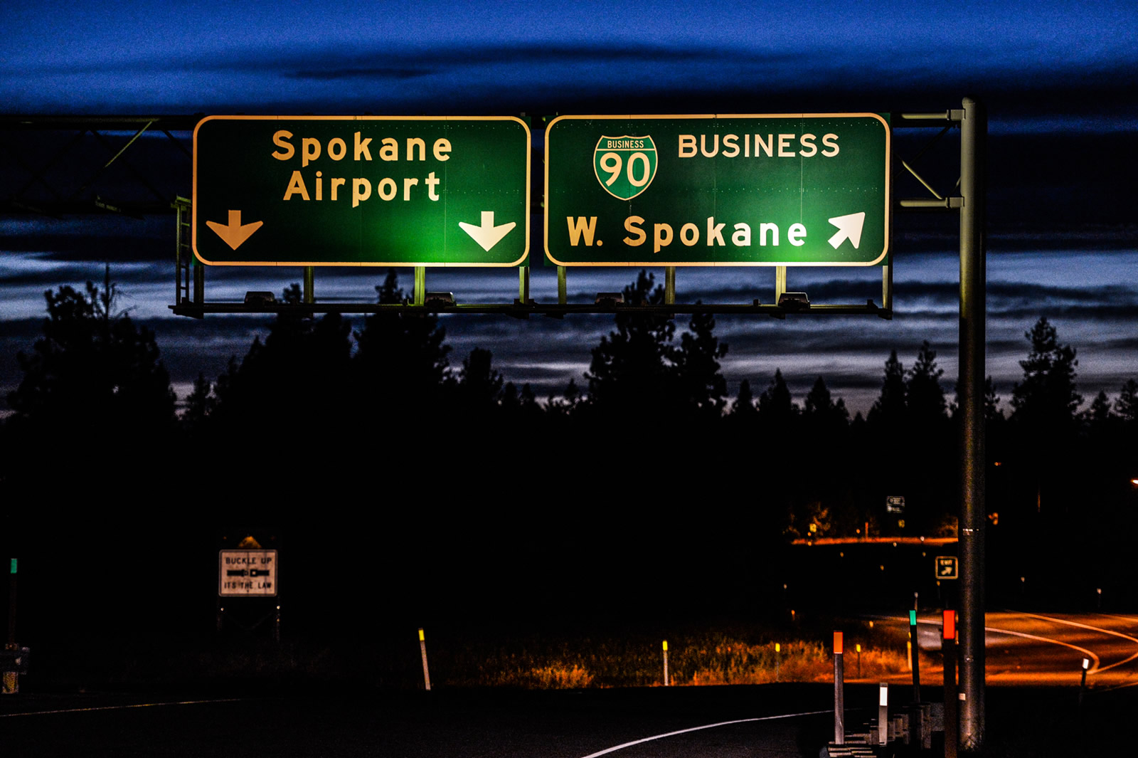
Guide signs on U.S. 2 west are the only remaining signs referencing the Spokane Business Loop for I-90.

Maple Street south between the former Business Loop I-90 couplet of West 2nd and 3rd Avenues in Spokane, Washington. This sign was removed by 2006. Photo by Mark Bozanich (08/00).
Ramsey Road travels south over Interstate 90 at Exit 11. Business Loop I-90 in Coeur d’Alene, Idaho began at this interchange.
The overhead pictured here was adjusted by 2012 to remove the business loop shield. 09/02/06

Trailblazers posted along Highway 10 West ahead of Park Street, where Business Loop I-90 overtakes old U.S. 10/89 to the Livingston, Montana city center. U.S. 89 bypasses the city via I-90 and U.S. 191 to the south but otherwise connects Livingston with Yellowstone National Park. 07/09/08
Older shield styles previously posted along Park Street west at the Business Loop I-90 (old U.S. 10) westbound split with old U.S. 89 in Livingston, Montana. This assembly was replaced by 2016. 07/09/08

Business Loop I-90 (Main Street) east at S-532 and 1st Avenue in Downtown Laurel. U.S. 310 formerly began here, but now starts 0.4 miles to the south at I- 90 and U.S. 212. As of 2016, two shields still allude to the original end point. 08/08/16
The weather worn shield for Business Loop I-90 here was replaced by 2011. 07/09/08

Along the northern tier of Wyoming, Interstate 90 has five business loops, one each for Sheridan, Buffalo, Gillette, Moorcroft and Sundance. Each of these routes overlap with U.S. highways.
Guide sign posted at the ramp end of Exit 153 for Business Loop I-90/U.S. 14-16 east into the Crook County, Wyoming town of Moorcroft. A replacement made here by 2016 incorrect displayed the business loop with a tri-color I-90 shield. 06/30/08
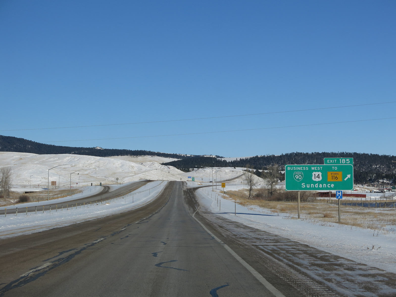
Interstate 90 east ahead of Exit 185 for Business Loop I-90/U.S. 14 east to Sundance, U.S. 14 west to Devils Tower and Hulett and WY 116 south to Upton. The business route serves the Crook County seat along a 3.9 mile long course. 12/28/12