
Interstate Business Route 80
Interstate 80 retains 19 business loops across the Western United States, including a business loop freeway in Sacramento.
California
Sacramento


Business Loop I-80 in Sacramento is a limited access highway encircling Downtown and Midtown. U.S. 50 overlaps with the business loop for the westernmost 5.5 miles. California State Route 99 also joins the loop between Exit 4 / I-5 and Exit 6 / Sacramento Freeway.
The route was established in 1980 over the former routing of Interstate 80 between West Sacramento and Sacramento near the community of Carmichael. This action occurred as the planned new alignment for I-80 replacing the substandard section along the eastern leg, including the Marconi Curve, was deleted by a Sacramento City Council vote taken in 1979.1 Instead of constructing a new section of freeway for I-80, the alignment was shifted northward over the Sacramento bypass, Interstate 880.
Subsequent actions by the Federal Highway Administration (FHWA) reclassified the old I-80 alignment from FAU (Federal-aid Urban) 6380 to FAP 51. State Senate Bill 191 followed these actions by deleting I-880 and formally rerouting I-80 over it.1 As defined in the California State Highway Code, legislative Route 51 was to be signed and designated as “Interstate Business Loop 80.” Route 51 runs from the U.S. 50/SR 99/Business 80 Northeast to the I-80/SR 244 (Auburn Boulevard) junction along the Elvas Freeway. To complete the loop, the section of Route 50 between the I-80/U.S. 50 junction in West Sacramento and the U.S. 50/SR 99/Business 80 junction is signed and designated Business Loop I-80 and U.S. 50.
An application to the American Association of State Highway and Transportation Officials (AASHTO) finalized the route changes. As approved on November 14, 1980, I-80 was rerouted over eliminated I-880, old I-80 was renumbered as Interstate 305 between the west end at former I-880 and the junction with U.S. 50 and SR 99 in Sacramento, while U.S. 50 was extended west. This kept the western portion of the route in the Interstate system as unsigned I-305. The substandard eastern section became unsigned SR 51.
Lastly, the California State Highway System Signing Log (October, 1991) defines the Sacramento business loop as from “Interstate 80 near West Sacramento over Legislative U.S. 50 to Legislative 50/51/99 Separation and over Legislative State Route 51 to Interstate 80 east of Watt Avenue.”
Business Loop I-80 was renamed the Capital City Freeway in 1996. The freeway serves commuters from the eastern suburbs and U.S. 50 through traffic as it links Interstate 80 to the west with Folsom, Placerville and Lake Tahoe to the east. The U.S. 50 component factored into a sign replacement project (Contract No. 03-4F7104) along Business Loop I-80 in 2015. Details from the project manager via Joe Rouse indicated that the de-emphasis of Business 80 on the U.S. 50 section is to simply things by providing motorists with a single route versus an overlap. This philosophy was reinforced with the 2014 completed “Fix50” project, where an increasing number of motorists referred to the jointly signed route as simply U.S. 50. Additionally, the legislative descriptions of Business Loop I-80 specify that the Route 51 section be signed as Business 80, while the Route 50 section includes no such requirement. Joe concluded that the loop essentially is now a spur, though formal sign changes reflecting that are not planned.2
Business 80 and Interstate 5 signage along westbound W Street near 5th Street in Sacramento, Calif. pic.twitter.com/tBjU202Q0A
— AARoads (@AARoads) May 22, 2015
Sacramento

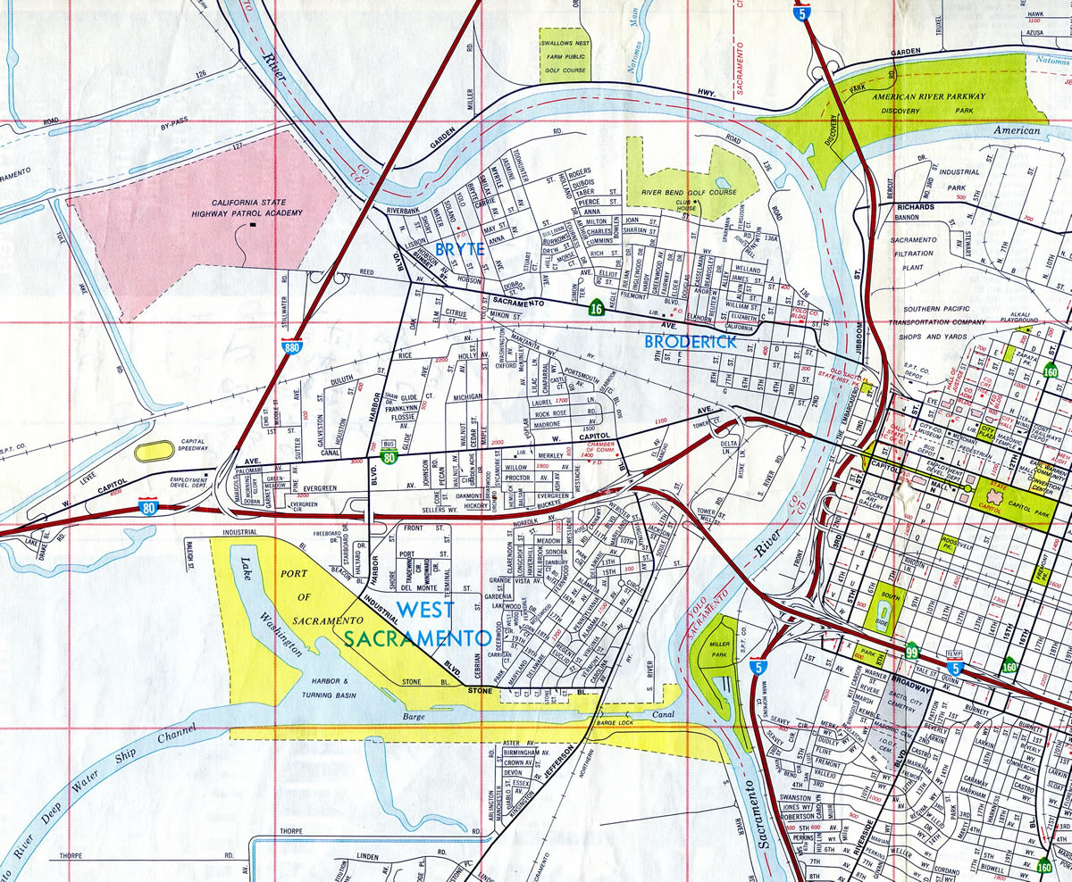
A possible earlier business route from Interstate 80 in Sacramento appeared on a 1963 Gousha map of Sacramento as U.S. 40 Business along West Capitol Avenue [see map at right]. The route parallel the West Sacramento Freeway (U.S. 40/99W) to the north from what is now Exit 81 east to the Tower Bridge. This includes a portion that no longer exists east of 5th Street.
According to Jerry Mullady, the route was later designated as Business Spur I-80. If the route was signed, it was not posted when the Business Loop 80 Freeway was commissioned in 1982.
Old 1970s AAA maps of Sacramento displayed Business Loop I-80 along W Capitol Avenue.
Truckee
Prior to 2002, there was exactly one Business Interstate 80 shield in the city of Truckee, and the business loop was only marked off of Interstate 80 heading westbound. When the signs were replaced in 2003-2004 as part of the reconstruction of I-80 near Truckee, all remaining references to the business loop were removed.
The business loop used to follow Donner Pass Road (old U.S. 40) and SR 267 between the Donner Park and SR 267 exits. The California State Highway System Signing Log (October, 1991) inventoried Business Loop I-80 in Truckee as running from
Interstate 80 and Donner Park overcrossing over Donner Pass Road and SR 267 to Interstate 80 and Legislative SR 89/SR 267 Separation.
The route today is signed as Historic U.S. 40.
Nevada
Verdi
Business Loop I-80 through Verdi forms a 4.5 mile arc from Exit 5 west to Exit 1. The eastbound beginning starts at Exit 2, while the southernmost extent comprises a west side frontage road to I-80. The business route runs concurrent with the partially signed Nevada State Route 425.
Supplemental signs reference the business loop in each direction of the Interstate 80 mainline.
Reno and Sparks
The Reno-Sparks business route from I-80 follows Fourth Street in Reno and Victorian Drive in Sparks. Beginning at Exit 12, the business loop lines a commercialized stretch of Keystone Avenue south from I-80 to 4th Street. Business Loop I-80 then follows 4th Street (old U.S. 40) east with local maintenance through Downtown Reno to the Sparks city line at Galletti Way. There it becomes SR 647 (Prater Way) through a diamond interchange (Exit 16) with Interstate 80.
The remainder of the route in Sparks parallels I-80 just to the north along Victorian Avenue. The east end ties into the McCarron Boulevard (SR 659) parclo interchange (Exit 19) with Interstate 80.
A handful of signs stand along the route through Sparks while the business loop through Reno is vastly unsigned.
Wadsworth and Fernley
Business Loop I-80 meanders 7.2 miles north from I-80 into Wadsworth and south to the city of Fernley along old U.S. 40. The business route overlaps with SR 427 east from Exit 43 to U.S. 50 ALT and U.S. 95 ALT in Fernley. Main Street carries the three routes east to a roundabout to SR 828 (Farm District Road). There Business Loop I-80/U.S. 95 ALT branch northeast to Interstate 80 at Exit 48.
Signs on the I-80 mainline omit the business loop and SR 437 for Wadsworth. The east Fernley exit acknowledges Business Loop I-80 with a stand alone shield assembly ahead of the westbound off-ramp.
Lovelock
The Lovelock business loop was formally approved by the AASHTO Route Numbering subcommittee on April 7, 2000, even though it had been signed throughout the 1990s. 1.6 miles in length, Business Loop I-80 runs along old U.S. 40/95 on SR 396 (Cornell Avenue) north from Exit 105 to SR 856 and a half diamond interchange at Exit 107.
Winnemucca
This business route follows old U.S. 40 along Winnemucca Boulevard for 7.5 miles. The western part of this route is cosigned with SR 289 as it parallels I-80 closely from Exit 173 to Exit 176, where U.S. 95 departs the freeway for Downtown Winnemucca via Business Loop I-80. U.S. 95 turns northwest along Melarkey Street while SR 289 remains along Winnemucca Boulevard to Exit 178. Business Loop I-80 turns just prior to that interchange and overlaps with SR 794 by the Humboldt County Fairgrounds to end at Exit 180.
Battle Mountain
The Battle Mountain business loop follows old U.S. 40 along Front Street through the unincorporated community. The route runs concurrently with SR 304 for 3.4 miles. End shields are posted at both Exit 229 / Allen Road and Exit 233 / Hill Top Road.
Carlin
Part of unsigned Nevada State Route 221, this business loop follows Chestnut Street (Old U.S. 40) through Carlin. Traveling 3.0 miles overall, Business Loop I-80 begins at SR 278 and Exit 279 to the west and ends at Susie Creek Way and Exit 282 to the east.
Elko
One of the larger cities between Reno and Salt Lake City, Business Loop I-80 through Elko joins portions of old U.S. 40 along a 5.5 mile route. The drive east from Exit 298 to SR 227 (5th Street) in Downtown Elko is state maintained and designated as SR 535. The route northeast along Idaho Street to Jennings Way and Exit 303 is locally controlled.
Wells
Business Loop I-80 through Wells navigates along the main streets through the city, Humboldt Street and Sixth Avenue (old U.S. 40). The 2.6 mile loop overlaps with SR 223 north from Exit 351 and east to U.S. 93 (Great Basin Highway). The east end separates between ramps from U.S. 93 south to I-80 east and from Exit 352 B west onto 6th Street.
Utah
West Wendover, Nevada and Wendover
The 2.9 mile route runs concurrent with U.S. 93 ALT in Nevada and with SR 58 east to Exit 2 in Utah. The Wendover Boulevard section of Business Loop I-80 between the junction with U.S. 93 ALT and the state line is locally controlled; it was formerly designated as Nevada State Route 224. A number of casinos along this stretch offer the closest gambling opportunity for residents of Salt Lake City.
U.S. 93 Alternate splits with I-80 at Exit 410 to connect with Lincoln Highway south via the business route. The Utah portion is only marked with one shield for SR 58 westbound.
Coalville
The State Road Commission approval of the Interstate business route policy in 1973 referenced a number of cities across Utah that qualified for business loops and spurs. Many were implemented, but some were not, including the potential Business Spur I-80 at the city of Coalville.3 The short route might have taken SR 280 (100 South) east from Exit 162 to Main Street (old U.S. 40/189).
Wyoming
Evanston
Evanston represents the first traveler services along Interstate 80 since the exchange with I-84 at Echo Junction. There Business Loop I-80 overlaps with U.S. 189 Business along a 3.2 mile route across the city from Exits 3 to 6.
Replacing U.S. 30S, the business route follows Harrison Drive east to Front Street south through the city center. Wyoming State Highway 89 combines with the route at 6th Street as the loop turns north onto a viaduct connecting with Bear River Drive. Bear River Drive returns the business route pair east while WY 89 ventures north to Bear River.
Meanwhile, in Evanston, Wyoming…
Posted by AARoads on Friday, August 12, 2016
Fort Bridger and Lyman
Green River
Named Flaming Gorge Way, Business Loop I-80 through Green River overlaps with U.S. 30 Business and marked with trailblazers for WY 530 south. The 2.5 mile route is a bypass for vehicles prohibited from passing under the Castle Rock tunnels along I- 80/U.S. 30 between Exits 89 and 91.
Interstate 80 and US 30 east approaching Green River …. the tunnels were fully open this summer (no lane restrictions).
Posted by AARoads on Tuesday, August 9, 2016
Rock Springs
Navigating along a winding course for 4.1 miles, the Rock Springs business route for I-80 arcs east from Exit 102 along the commercial arterial of Dewar Drive to Center Street. Business Loop I-80/U.S. 30 Business continue east from Elk Street along Bridger Avenue and Pilot Butte back to Interstate 80 at Exit 107.
A few newer signs are posted along Interstate 80 and US 30 eastbound around the Rock Springs area, some of which are…
Posted by AARoads on Tuesday, August 9, 2016
Rawlins
This business route branches north from I-80 at Exit 211 alongside U.S. 30 Business/WY 789 (Cedar Street) to the Rawlins city center. There WY 789 turns north onto 3rd Street as U.S. 287 south combines with the business routes. The three routes run south three blocks to Cedar Street, which directs them eastward to a trumpet interchange with I-80 at Exit 215.
Laramie
Business Loop I-80 through Laramie stems east 1.3 miles from Exit 310 along Curtis Street to U.S. 30/287 (3rd Street). 3rd Street, a four to five lane commercial boulevard, takes all three routes south 1.1 miles to Grand Avenue at the city center. The eastern four miles of the business route travel solo on Grand Avenue to the University of Wyoming campus, War Memorial Stadium and growing suburban areas to rendezvous with Interstate 80 at Exit 316.
Cheyenne
Serving Wyoming’s capital city, Business Loop I-80 doubles as U.S. 30 (Lincolnway) along a 6.9 mile artery. The route separates with I-80 on the western outskirts of Cheyenne at Exit 358, opposite WY 225 (Otto Road). The initial stretch of Lincolnway parallels a Union Pacific Railroad corridor east as a four lane divided highway by a number of motorists services and business parks.
Shifting into the Cheyenne street grid, Business Loop I-80/U.S. 30 transition into a five lane boulevard to Downtown, where they intersect Interstate 180, Business Loop I-25/U.S. 85-87 Business. This rare meeting of two Interstate business routes coincides with the north end of the expressway along I-180 leading south to Exit 352.
Continuing east, Business Loop I-80/U.S. 30 wrap around Holliday Park to a business district across east Cheyenne. The two routes separate by Cheyenne Plaza Shopping Center, with U.S. 30 remaining east along Lincolnway to growing suburban areas and Business Loop I-80 combining with WY 212 (College Drive) south to reconnect with I-80 at Exit 364.
Pine Bluffs and East Pine Bluffs, Nebraska
The final business route for I-80 follows Parsons Street and Lincoln Highway (old U.S. 30) through the town of Pine Bluffs. Beginning opposite the Wyoming welcome center at Exit 402, the business route overlaps with U.S. 30 Business to the state line and the intersection with Link 53B. U.S. 30 turns south from Bushnell along L-53B to converge with I-80 at a rural diamond interchange.
Business Loop I-80 was omitted from Interstate 80 mainline guide signs in both states by 2005. Two shields remained in 2009 along the Nebraska side of the loop at both the westbound off-ramp (Exit 1) from I-80 and at the north end of Nebraska L53B. They were taken down by 2012, reflecting a likely decommissioning of the route in the Cornhusker State.
Several assemblies for Business Loop I-80/U.S. 30 Business were posted by 2012 in Pine Bluffs, Wyoming. These appear along Parsons Street at WY 215 (8th Street) and at the turn of the loop east onto Lincoln Highway (old U.S. 30).
Nebraska
Sidney
The nine mile route of Business Loop I-80 through Sidney served the largest city along the I-80 corridor between Cheyenne, Wyoming and North Platte, a distance of 210 miles. The business route overlapped with Nebraska Highway 19 north from Exit 55 to U.S. 30 (Lincoln Highway) east through the city center to L-17J south back to I-80 at Exit 59.
All signs for the Sidney business route from I-80 were removed or greened out by Spring 2009.4
Sources:
- Interstate 80. California Highways web site (Daniel Faigin).
- “Re: District 3/Sacramento – Sign Replacement Project” online posting by jrouse, AARoads Forum, September 26, 2015.
- “Utah Okays Business Loop Policy.” The Deseret News, April 30, 1973.
- “I-80 Sidney Nebraska Business Loop decommissioned” online posting by corco, AARoads Forum, April 2, 2009.
Page updated August 26, 2016.
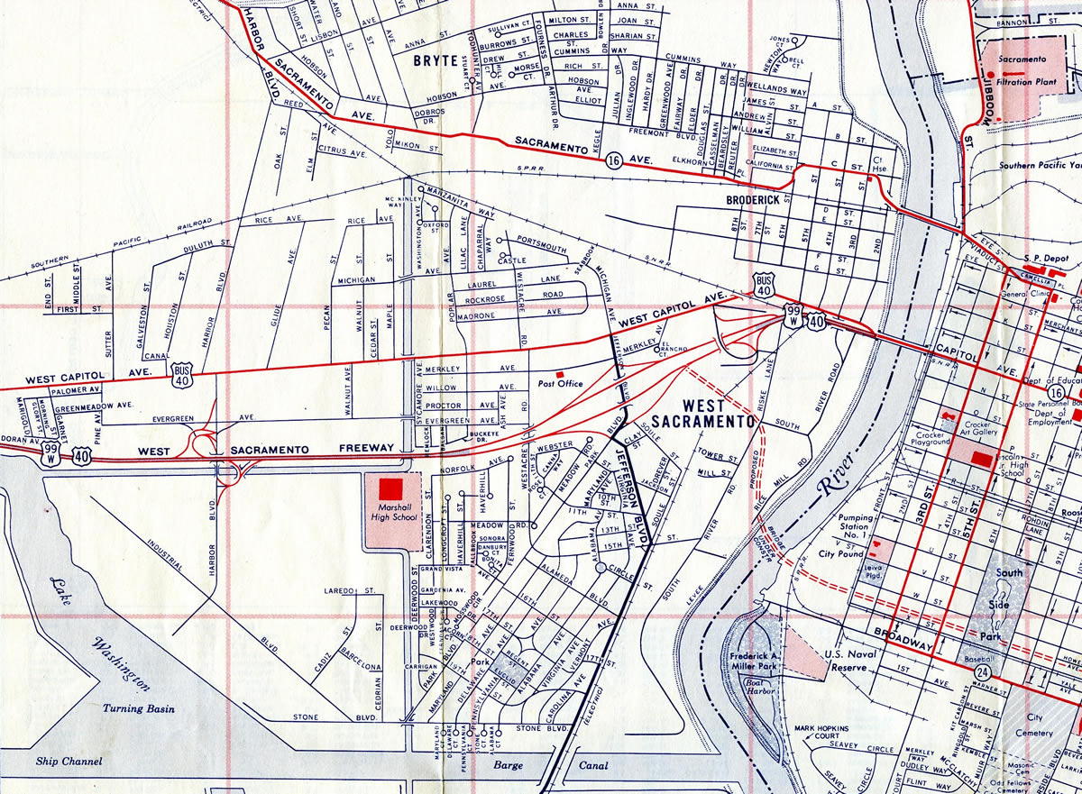
U.S. 40 Business assigned to West Capitol Avenue – 1963 Gousha map of Sacramento. This route may have been the predecessor of the first Sacramento business loop for Interstate 80.
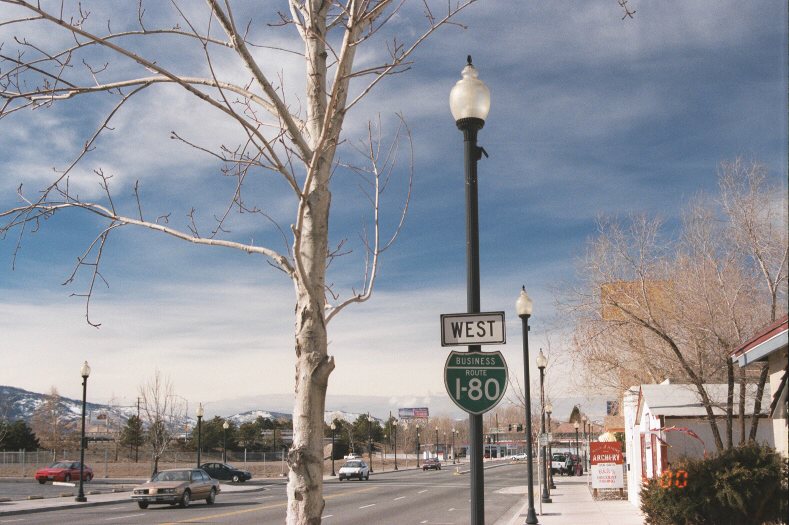
Reassurance marker for Business Loop I-80 west along Victorian Way (old U.S. 40) through Sparks, Nevada. Photo by Jeff Royston (01/14/00).
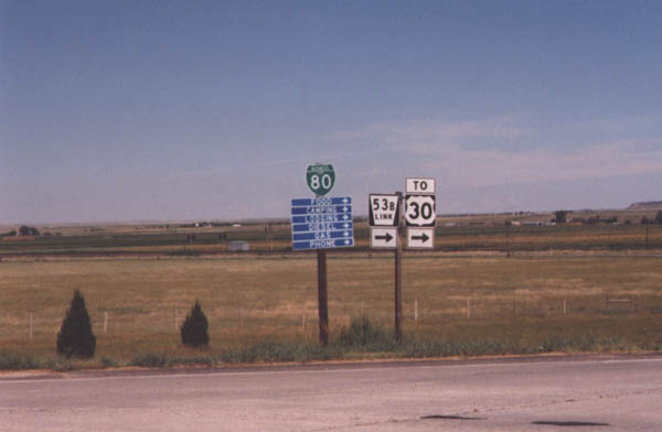
One of two shields for Business Loop I-80 formerly posted for the Pine Bluffs, Wyoming business route along L-53B in Nebraska. August 1998