Interstate Business Route 15
Interstate 15 has 25 active business routes, almost all of which replaced U.S. 91.
California
Escondido


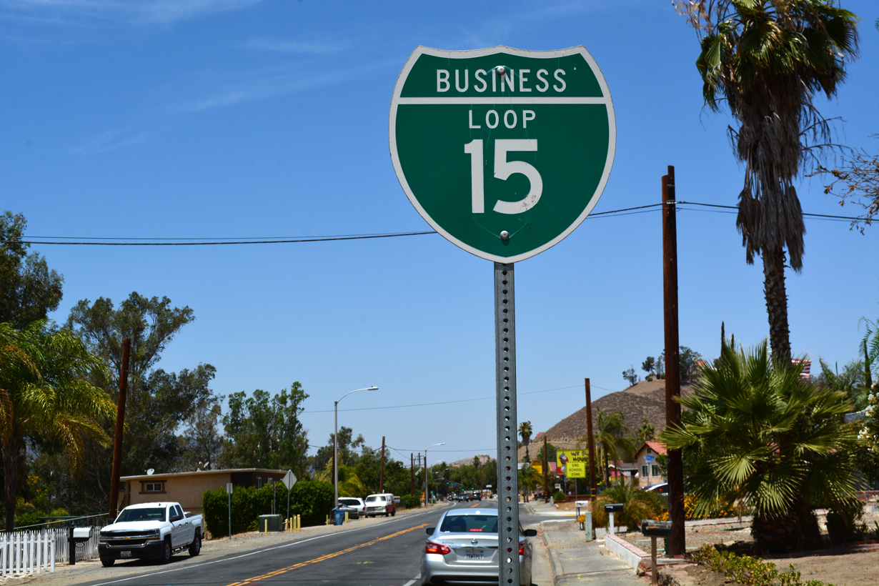
Business Loop I-15 through Escondido is one of the best signed business routes in California. It follows Centre City Parkway, an expressway grade route through Escondido between Exits 28 and 34 from I-15. Business Loop I-15 represents a former routing of U.S. 395 through North San Diego County. An even older alignment for U.S. 395 traveled through the city along Escondido Boulevard.
The California State Highway System Signing Log (October, 1991), lists the Escondido business loop from
Interstate 15 and South Direct Connection under crossing near Escondido south city limits over Centre City Parkway to Interstate 15 and Escondido Expressway near Escondido north city limits.
Lake Elsinore


The Lake Elsinore business route for I-15 comprises both a 3.3 mile loop along Diamond Drive, Lakeshore Drive and Main Street (old SR 71) between Exits 73 and 75, and also a 2.6 mile long spur extending west on Lakeshore Drive to SR 74. According to the California State Highway System Signing Log (October, 1991), Business Loop I-15 runs from Interstate 15 and Main Street over Main Street to Graham Avenue. Loop 15 “north” runs from Main Street over Graham Avenue to Riverside Avenue (SR 74), and Loop 15 “south” runs from Main Street over Lakeshore Drive and Railroad Canyon to Interstate 15.
Business Loop I-15 through Lake Elsinore is locally maintained and poorly signed beyond the freeway. A sign assembly previously acknowledged the north end of the business loop at SR 74. It was removed sometime after 2011 during a landscaping project for a local business.
Norco
Norco is short for “North Corona.” Business Loop I-15 here follows Second Street west from Exit 98 to Hamner Avenue (old SR 31) north. Hamner Avenue parallels I-15 north to Sixth Street, which returns Business Loop I-15 to Interstate 15 at Exit 100. The 2.6 mile route is locally maintained. It was not inventoried in the 1991 state signing log.
Victorville
The Victorville business route is locally maintained with the exception of its concurrent section with California 18. Business Loop I-15 follows Seventh Street and D Street (California 18) between Exits 150 and 153A. Forming an L-shaped route for 3.8 miles, Business loop I-15 is also part of Historic U.S. 66-91.
As inventoried in the California State Highway System Signing Log (October, 1991), Business Loop I-15 in Victorville runs
from Interstate 15 and Palmdale Road overcrossing over Seventh Street and State Route 18 (D Street) to Interstate 15 and Legislative State Route 18 separation.
San Bernardino County 66 signs were posted along the former route of U.S. 66 in 2012. This included installations along the business loop segment in Victorville.
Barstow
Business Loop I-15 serves Barstow via L Street and Main Street along portions of Historic U.S. 66 and old U.S. 91 between Exits 181 and 184. This 4.8 mile business loop is somewhat unusual in that the northern terminus is actually located at Interstate 40, east of I-15. The California State Highway System Signing Log (October, 1991) inventoried the Barstow business loop as following Main Street.
The route is well posted in both directions. County Road 66 shields were added to the route in 2012 to acknowledge the former alignment of U.S. 66.
Baker

Baker provides a major oasis in the Mojave Desert for food, gas and lodging. The census designated place is also home to the 134 foot high Baker Thermometer, the world’s largest. Locally maintained, the 3.6 mile long business loop for I-15 through Baker follows old U.S. 91-466 between wye interchanges at Exits 245 and 248. No signage, either from the freeway or along the main street, is posted for Business Loop I-15. The Baker loop was also not listed in the 1991 state signing log.
Nevada
Las Vegas

A few maps, including a Compass map of Las Vegas, referred to former Nevada State Route 604 (Las Vegas Boulevard and The Strip), and possibly former SR 601 (Main Street), as Business Loop I-15 in the 1980s. Despite the map references, no signs for the business route have ever been observed along the Strip.
Mesquite
SR 144 was decommissioned in 2005, but signage for the business route remains. With local maintenance, it is unclear if the business route will continue to be signed.
We found two Nevada 144 shields at the intersection of Business Loop I-15 (Mesquite Blvd) and Nevada 170 (Riverside…
Posted by AARoads on Sunday, August 14, 2016
Utah
St. George
Business Loop I-15 through St. George travels 4.4 miles. The route travels north alongside SR 18 (Bluff Street) between Exit 6 and SR 34. SR 34 (St. George Boulevard) leads the route east back to I-15 at Exit 8.
Cedar City
Business Loop I-15 through Cedar City follows SR 130 and portions of former U.S. 91 between Exits 57 and 62. The route is unmarked along Cross Hollow Road and Main Street.
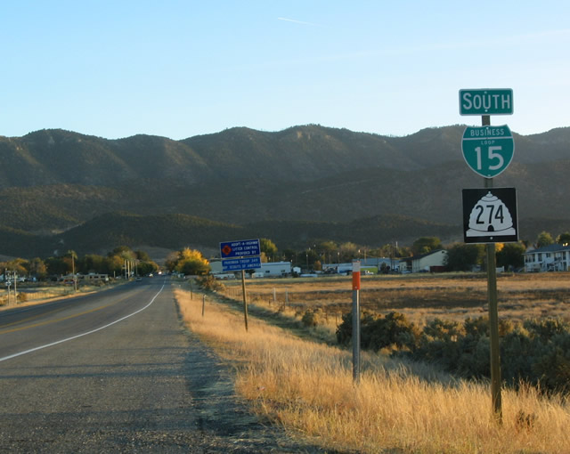
Parowan
Business Loop I-15 follows SR 143 (200 South) east from Exit 75 to Main Street and the Parowan city center. The nearly four mile long route returns to I-15 via SR 274 (Main Street) along old U.S. 91 to Exit 78.
Beaver
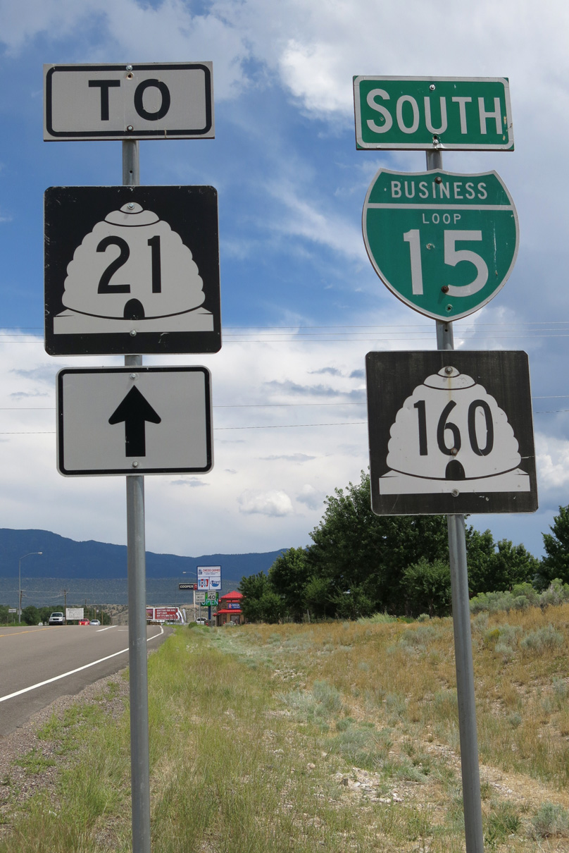
Business Loop I-15 overlaps with SR 160 over the former route of U.S. 91 (Main Street) between Exits 109 and 120. SR 21 east and SR 153 west end at the business route in the Beaver city center.
Fillmore
Traveling 4.2 miles east from Interstate 15, Business Loop I-15 overlays SR 99 along old U.S. 91. The route angles northeast from Exit 163 to 500 South. Main Street leads the business loop north to the city center en route to a diamond interchange (Exit 167) at Cedar Mountain Road.
Holden
Business Loop I-15 used to follow SR 64 north from Exit 174 to Main Street (old U.S. 91) through the town of Holden. The 2.02 mile long route of SR 64 ends at the turn of U.S. 50 north of the town limits. U.S. 50 extends northeast from there to combine with I-15 at Exit 178. This was the northern extent of the former business loop.
No signs of a business loop remain in Holden. Furthermore, a no services sign was added for the SR 64 exit from I-15 as of July 2008.
Nephi
The Juab County seat of Nephi has three interchanges from Interstate 15. Two represent the end points of Business Loop I-15, which follows old U.S. 91 on Main Street. The 4.9 mile route runs in tandem with SR 28 north from Exits 222 to 228. SR 28 replaced SR 41 along the loop when it was extended north from Exit 222.
Payson
The Interstate Business Route policy was approved in Utah by the State Road Commission in April 1973. A number of routes were established, while other qualifying cities never implemented them. Payson could have posted a business spur from I-15.1 The route may have utilized 800 South (SR 178) east to old U.S. 91 (SR 198) from Exit 249 or Main Street (SR 115) south from Exit 250 to the city center.
Spanish Fork
Spanish Fork qualified for a business loop from I-15 per the 1973 policy adopted by Utah.1 A possible route included 8000 South and Arrowhead Trail (SR 164) east from Exit 253 to old U.S. 91 (Main Street), and Main Street (SR 198 / SR 156) north to Exit 257.
Springville
The 1973 policy specified that a second business spur from I-15 could have been implemented from I-15 east to the city of Springville.1 The route likely would have used 400 South (SR 77) east from Exit 260 to U.S. 89 (Main Street) at the city center. It was not posted in 1990 and probably never was.
Layton
This business loop was previously routed along SR 126 (Main Street) through Layton. Dan Stober reported that guide signs posted on I-15 north for Exit 332 referenced Business Loop I-15, but that beyond the freeway along SR 126 and Main Street, signs were not present. A follow up visit by July 2008 revealed no signs for the route along Interstate 15.
Brigham City
As first reported by Dan Stober on November 21, 1998, the Brigham City business route for I-15/84 consists of a 7.7 mile long loop east through the Box Elder County seat. The south leg of the route follows U.S. 91 from a diverging diamond interchange (Exit 362) completed in July 2014 east to U.S. 89 and SR 13 at Main Street. SR 13 (Main Street) leads the route north through the city center to SR 38, where the pair turn west to I-15/84 at Exit 365.
Business Loop I-15/84 run concurrent throughout the alignment, with shields posted along Main Street, at the junction of U.S. 89 and U.S. 91 and on the southbound off-ramp to SR 13. These were noted in July 2016. Mainline signs from I-15 and I-84 omit the business routes and instead display U.S. 91 at the south end and SR 13 at the north end.
The Brigham City Business Loop is unsigned from the I-15/84 mainline but acknowledged by this assembly on the southbound off-ramp. Several fires underway in the area too.
Posted by AARoads on Wednesday, August 10, 2016
Tremonton and Elwood
A second cosigned route for Business Loop I-15/84 branches north from I-15/84 at Exit 376 in the town of Elwood. The pair follow SR 13 (5200 West) north to a rural intersection with SR 102 (Main Street), where they turn west into the city of Tremonton. Beyond the city center, Business Loop I-15 rejoins I-15 via the locally maintained roads of 1000 West and 1000 North to Exit 381. Business Loop I-84 remains paired with SR 102 to I-84 at Exit 40.
Shields or trailblazers for I-15 and I-84 were posted on Main Street at 1000 West and other turns the routes make as observed in July 2016.
Tremonton Business Loop. Signed well for the most part.
Posted by AARoads on Friday, July 8, 2016
Idaho
Malad City
The 1995 DeLorme Idaho Atlas indicated that a connection to old U.S. 191 in Malad City was a business route. However, subsequent field inspection in 2008 confirmed that this business spur was not posted.
McCammon
Business Loop I-15 serves the city of McCammon, partially along the old route of U.S. 91/191. The route stems east along Jensen Road to State Street from Exit 44. State Street winds northward across agricultural areas to the city street grid, where Business Loop I-15 shifts to Center Street to the McCammon business district. A short overlap with U.S. 30 returns the loop to Interstate 15 at Exit 47.
Several shields were observed along the route in August 2016.
Inkom
Business Loop I-15 overtakes a portion of old U.S. 30-91-191 between a wye interchange (Exit 57) and half diamond interchange (Exit 58) through the city of Inkom. An end sign stands at the split with Old Highway 91 southbound as of August 2016. A handful of services line the route.
Pocatello
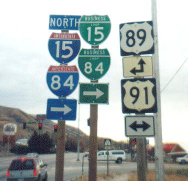
Interstate 15 travels along the east side of Pocatello on a hill overlooking the city while Business Loop I-15 provides direct routes to both the city center and Idaho State University.
The route branches northwest from Exit 67 along 5th Avenue, which doubles as U.S. 30/91. The three routes separate into a couplet with 4th Avenue carrying southbound traffic to Pocatello Avenue. U.S. 30 splits with the business route at Oak Street while U.S. 91/Business Loop I-15 shift to Yellowstone Avenue, a five lane commercial boulevard.
U.S. 91 remains north along Yellowstone Avenue en route to Chubbuck while Business Loop I-15 turns east along Alameda Road and Pocatello Creek Road to end at Exit 71. The Business Loop I-15 overlap with U.S. 91 was well signed as of August 2016, while the branch to Exit 71 was less acknowledged.
Good morning from Idaho!
Posted by AARoads on Friday, July 8, 2016
Blackfoot
The Blackfoot business route for I-15 overlays U.S. 91 (Broadway and Main Streets) from Exit 89 north to the city center. This section was previously the alignment of U.S. 191. The remainder of the route west along the couplet of Bridge and Judicial Streets and the commercial arterial back to I-15 at U.S. 26 / Exit 93 is a stand alone route.
During the late 1980s and early 1990s, Rand McNally incorrectly showed Business Loop I-15 following all of U.S. 91 between Blackfoot and Idaho Falls. Several shields were noted between Exit 93 and U.S. 91 during a August 2016 visit.
Business Loop I-15 north split with US 91 in Blackfoot #Idaho #roads pic.twitter.com/an46anDYq8
— AARoads (@AARoads) August 9, 2016
Idaho Falls
Beginning at Exit 116, Business Loop I-15 combines with U.S. 26 east along a four lane arterial to cross the Snake River and intersect the north end of U.S. 91. U.S. 26/Business Loop I-15 turn north at Sunnyside Road to parallel a railroad corridor northward to Yellowstone Avenue (old U.S. 91) and Downtown Idaho Falls.
Broadway Street takes Business Loop I-15/U.S. 20 Business west across the Snake River at the actual Idaho Falls to Exit 118. U.S. 26 east overlaps with U.S. 20 Business northeast to Northgate Mile.
Turn of Business Loop I-15 in Downtown #Idaho Falls. #roads pic.twitter.com/WfuMlXBS81
— AARoads (@AARoads) August 9, 2016
End for both I-15 Business Loop and the U.S. 20 Business loop at I-15.
Posted by AARoads on Tuesday, August 9, 2016
Montana
Dillon
Dillon represents the main service center along the I-15 corridor between Idaho Falls, Idaho and Butte, Montana. A 3.3 mile business loop there joins the city center with Interstate 15 from Exits 62 and 63. The route zigzags through the street grid along a combination of Atlantic, Helena and Montana Streets, which collectively represent old U.S. 91. Business Loop I-15 also provides the connection between Interstate 15 and MT 41 north to Twin Bridges.
The Dillon #Montana Business Loop for I-15 is well signed with a good array of services. #roads
— AARoads (@AARoads) August 9, 2016
Butte
I-15/90 overlap for 7.65 miles across Butte and Silver Bow County. The pair combine in a rural area west of Rocker and split outside the Floral Park neighborhood of the city. A cosigned business route connects I-15/90 with Downtown Butte between Exits 124 and 127. Business Loop I-15/90 overlap with I-115 east to Iron Street, where they make a horseshoe shaped route north along a combination of Montana Street, Park Street and Arizona and Utah Avenues. Harrison Avenue (old U.S. 10/91) angle the routes southeast along a commercial boulevard to I-15/90 opposite the north end of MT 2.
The USGS Topo map shows Business Loops I-15/90 taking a shorter route from Interstate 115 and Iron Street east to Montana Street south and Front Street east. A pair of older shields stand at the Front Street intersection with Utah Avenue, where the two different alignments combine east to Harrison Avenue.
Business Loop pair on #Montana Street in Butte. #roads pic.twitter.com/Yu8nWcPzU4
— AARoads (@AARoads) August 9, 2016
Helena
The capital city business loop for I-15 takes a convoluted 4.4 mile route west from Exits 192 to 193. Signs reference the route from the freeway mainline, but the route itself is poorly posted. U.S. 12 runs concurrent with Business Loop I-15 along a couplet of Prospect Avenue west and 11th Avenue east between a parclo interchange with I-15 and Montana Avenue. Trailblazers for U.S. 12 take the place of Business Loop I-15 shield along westbound while I-15 trailblazers are posted eastbound.
U.S. 12 turns north onto Montana Avenue and west along Lyndale Avenue to bypass the Helena city center. The business loop extends west along 11th Avenue through residential neighborhoods to Cruse Street and Last Chance Gulch at Downtown Helena. This stretch of the route is unmarked.
An array of trailblazers for both Interstate 15 and U.S. 12 stand at the five point intersection of Cruse Street, Helena Avenue, Neill Avenue and Last Chance Gulch. These assemblies direct traffic on Last Chance Gulch north and 11th Avenue east for Business Loop I-15 and 11th and Neill Avenues for U.S. 12 Business.
Last Chance Gulch leads northeast to become Cedar Street, a commercial arterial returning Business Loop I-15 to I-15 across from Helena Regional Airport (HLN). Erroneous trailblazers for Business Loop I-15 are posted along the route eastbound at both U.S. 12 (Lyndale Avenue) and Montana Street while U.S. 12 trailblazers line westbound.
Vastly unsigned Business Loop for I-15 in Helena.
Posted by AARoads on Thursday, July 7, 2016
Great Falls
Two of the three Great Falls interchanges from Interstate 15 connect with Business Loop I-15. The southern extent commences from a trumpet interchange (Exit 278) alongside unsigned Interstate 315, U.S. 89, MT 3/200. A short freeway ensues east to the signalized intersection with 6th Street (old U.S. 89 Bypass/U.S. 91) north across the Sun River. With I-315 ended, Business Loop I-15 transitions to 10th Avenue South across the Missouri River.
East of the river, 10th Avenue South constitutes a busy commercial arterial to Holiday Village Mall, U.S. 87 (14th / 15th Streets) and the University of Great Falls. Business Loop I-15 splits with U.S. 89/MT 3-200 for the couplet of 5th and 6th Streets. The street pair take the route north to Downtown Great Falls, where a second couplet (1st and 2nd Avenue N) turns the business loop back west toward the Missouri River.
1st Avenue N carries two way traffic west from Park Drive and Gibson Park across the Missouri River to Central Avenue. Central Avenue concludes Business Loop I-15 at a diamond interchange (Exit 280).
Old spec Business Loop shields remain in service along the couplet in Great Falls, #Montana #roads pic.twitter.com/lP7Jh5Hh1e
— AARoads (@AARoads) July 7, 2016
Conrad
The Conrad business loop for I-15 overlays a portion of old U.S. 91 along a 5.7 mile loop west from Interstate 15. The route starts at a rural diamond interchange (Exit 335), south of the city, to overtake Highway 91 west from Midway Road. Main Street leads the route north to the city center and back to I-15 at Exit 339.
A number of traveler services line the route at the north end of Conrad. The route is well posted in each direction.
Last sign for BL I-15 in Conrad. 2013 shield, 2016 banner.
Posted by AARoads on Monday, August 8, 2016
Shelby
Shelby lies at the crossroads of Interstate 15 and U.S. 2 in far northern Montana. The regional service center is also the site of the BNSF Intermodal Hub. The two interchanges for the Tooele County seat represent the end points of the 3.0 mile long Business Loop I-15 through Shelby.
Business Loop I-15 combines with U.S. 2 east from Exit 363 along Front Street to the city center, where both routes dog leg south on 5th Avenue to Main Street. U.S. 2 takes Main Street east to exit the city while the business route ascends onto a viaduct over the BNSF Railroad yard. Oilfield Avenue (old U.S. 91) returns the route north to I-15 at Exit 364.
Shelby, Montana Business Loop. The loop also has it's own truck route to circumvent downtown from the east.
Posted by AARoads on Thursday, July 7, 2016
Sources:
- “Utah Okays Business Loop Policy.” The Deseret News, April 30, 1973.
Page updated June 28, 2018.
Business Loop I-15 in California follows old alignments of U.S. 395, U.S. 91 and U.S. 66.
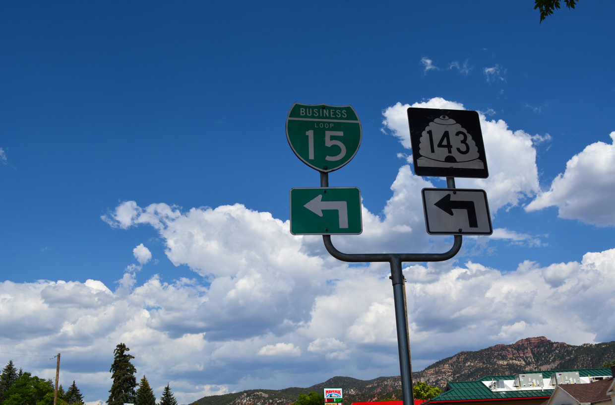
Business Loop I-15/SR 143 shields at the northern turn from 200 South to Main Street in Parowan, Utah. All Interstate business loops in Utah are cosigned with state routes. 07/15/17
Business Loops I-15/84 south turn west from the end of SR 13 to accompany U.S. 91 back to I-15/84. U.S. 89 branches south from U.S. 91 along Main Street to the city of Perry. Photo by Dan Stober (03/15/01).

U.S. 89/91 overlap 25 miles from Logan City, Utah at the south end of SR 13 and the turn of Business Loop I-15/84 west from Main Street onto U.S. 91 in Brigham City. Photo by Dan Stober (03/15/01).

Business Loop I-15/84 south at the rural town of Elwood in northern Utah. 07/13/08
This set of signs was replaced after 2008 when the intersection of Pocatello Avenue and Oak Street was expanded to include dual turn lanes for U.S. 30 west and two through lanes for Yellowstone Avenue north.
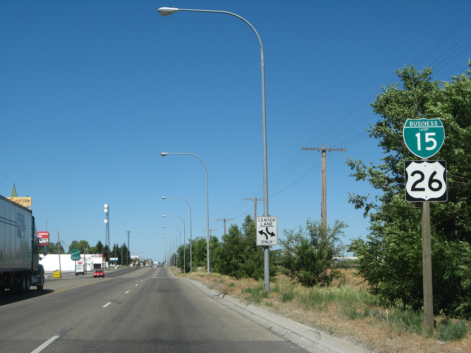
Business Loop I-15 and U.S. 26 overlap north between U.S. 91 and Idaho Falls, Idaho. 07/13/08