Interstate Business Route 5
Interstate 5 has several business routes in California and a lone remaining route in Washington. None of them are well signed due to the fact that most are locally maintained. Additionally, many business routes for I-5 were decommissioned, including all of those formerly posted in Southern California per the October 1991 California State Highway System Signing Log.’
California
San Ysidro (San Diego), National City and Chula Vista

According to many maps from the 1960s, the original route of U.S. 101 (Beyer Boulevard, Broadway, Harbor Drive, and Pacific Highway) was signed for a time as Business Loop I-5. However, all references and signage for this route were removed by the 1990s.
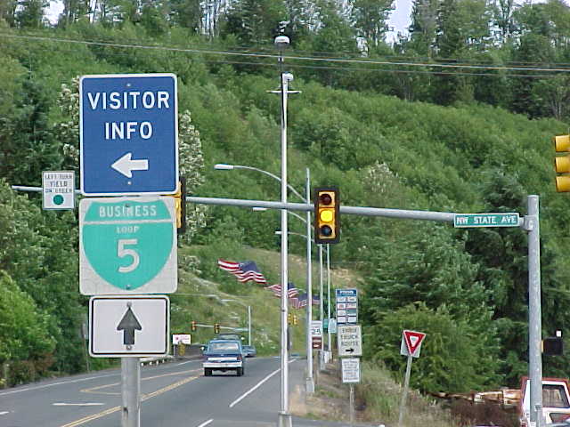
San Diego

Mission Bay Drive loops west between a pair of wye interchanges (Exit 23 A northbound / Exit 23 southbound) to connect I-5 with Grand and Garnet Avenues west to the Pacific Beach business district. The boulevard represents a 1.5 mile long section of old U.S. 101 (Pacific Highway).
A “Route 5 Business Next Right” placard remained posted on southbound Interstate 5 until a vehicle accident knocked it out in late 2008. Reassurance markers for the route were removed in 2004-05 with the exception of a southbound assembly posted at Grand Avenue, which was finally taken down by January 2016.
San Diego, Del Mar, Solana Beach, Encinitas (Leucadia/ Cardiff), Carlsbad and Oceanside
Included in the route of San Diego County Route S21 (Torrey Pines Road, Camino del Mar, Coast Highway 101, Carlsbad Boulevard, and Coast Highway), this former business route traveled along the original U.S. 101 alignment. Early map appearances included early 1960s ACSC (Auto Club of Southern California, a branch of the national AAA) maps, especially when the freeway only bypassed Oceanside and Carlsbad as far south as Palomar Airport Road (San Diego County Route S12). A mid 1960s Automobile Club Association of Southern California map showed portions of former Business Loop I-5 along what is now Historic U.S. 101 (Coast Highway) through Oceanside and Carlsbad. A remnant of this long business route is perhaps the Solana Beach business loop.
Solana Beach and Del Mar
This branch of Business Loop I-5 followed a combination of San Diego County Route S6 (Via de la Valle), CR S21 (Coast Highway 101 / Old U.S. 101) and CR S8 (Lomas Santa Fe Drive). A handful of signs, including an end assembly, were posted for the route at the Via de la Valle exit near the Del Mar Racetrack south of Solana Beach. The remainder of the loop is completely unsigned and the mainline “Route 5 Business Next Right” sign was removed from the northbound lanes in 2000.
Solana Beach and Del Mar
This instance of Business Loop I-5 followed a combination of San Diego County S6 (Via de la Valle), San Diego County S21 (Coast Highway 101 / Old U.S. 101) and San Diego County S8 (Lomas Santa Fe Drive). A handful of signs, including an end assembly, were posted for the route at the Via de la Valle exit near the Del Mar Racetrack south of Solana Beach. The remainder of the loop is completely unsigned and the mainline “Route 5 Business Next Right” sign was removed from the northbound lanes in 2000.
San Clemente
The business route for I-5 through San Clemente followed El Camino Real northward from Exit 72. Trailblazers for I-5 were posted along the loop in lieu of reassurance markers for Business Loop I-5. The lone remaining sign for the route stands along Interstate 5 northbound prior to the Cristianitos Road off-ramp.
Los Angeles
A former business loop for Interstate 5 used to follow the alignment of Historic U.S. 6-99 on San Fernando Road. According to Daniel Faigan at California Highways, it was signed as an Interstate 5 business route in the early 1970s. Prior to the Interstate system, portions were briefly posted as Business U.S. 99 per Rand McNally maps in the 1950s. This route is now signed as Historic U.S. 99.
Coalinga
A Compass map from the early 1990s displayed a business loop to Coalinga, originating at Exit 325 and ending at Exit 337. The business route traveled west along Jayne Avenue to SR 33 north and Polk Street to SR 198 (Elm Avenue) in the city of Coalinga. SR 33/198 extended the route north to their split, with SR 33 (Coalinga-Fresno Road) returning Business Loop I-5 to the freeway.
This route may never have been posted or was a cartographic error. Furthermore it did not appear in the Caltrans system signing log from 1991 and no signs have ever been observed for the route.
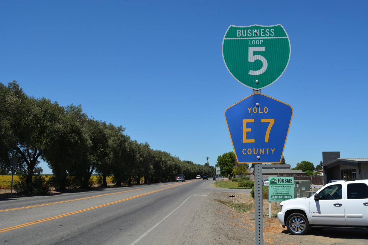
Woodland

The California State Highway System Signing Log (October, 1991) references Business Loop I-5 in Woodland from “Interstate 5 and Main Street under crossing over Main Street and SR 16 (CR 98) to Interstate 5 at the CR 18 over crossing.” Business Loop I-5 follows portions of old U.S. 99W and the old alignment of SR 16 (Main Street) across the city. The L-shaped route commences a 6.4 mile long route at Exit 537. The north to south leg doubles as SR 16 and CR E7 to the end at Exit 540.
Signs for the Woodland business route are sporadic but the turn at Main Street and Road 98 is marked.
Arbuckle
The 1.1 mile long business route for Interstate 5 at Arbuckle runs from the “Interstate 5 and Hillgate Road under crossing over Fifth Street to Interstate 5 and North Arbuckle under crossing” per the California State Highway System Signing Log (October, 1991). This alignment superseded U.S. 99W along Fifth Street.
Williams and Maxwell
A mostly rural route, Business Loop I-5 between Williams and Maxwell parallels I-5 closely for 13.8 miles. Beginning at Exit 575 with Husted Road, the business loop connects with Old Highway 99W north en route to 7th Street through the city of Williams, where it intersects California 20 Business (E Street). Staying west of I-5 across farm land, Business Loop I-5 advances north to the railroad siding of Cortena en route to the unincorporated community of Maxwell. A half diamond interchange concludes the route at Exit 588.The California State Highway System Signing Log (October, 1991) references Business Loop I-5 in Williams as
from Interstate 5 and Husted Road overcrossing over old U.S. Highway 99W, Seventh Street, and old U.S. Highway 99W to Interstate 5 and the North Maxwell overcrossing.
Willows and Orland
Stretching 20.7 miles, Business Loop I-5 through northern Glenn County follows old U.S. 99W from Exit 601 at the city of Willow to County Route 7 at Exit 621. The route traverses agricultural areas north from Willows to the communities of Bluegum and Artois before reaching Downtown Orland.
The route appeared on the August 1998 California State Automobile Association Northern California Section map and is listed in the California State Highway System Signing Log (October, 1991) as from
Interstate 5 and County Road 57 over crossing via old U.S. 99W and County Road 7 to Interstate 5 and County Road 7 over crossing
Red Bluff
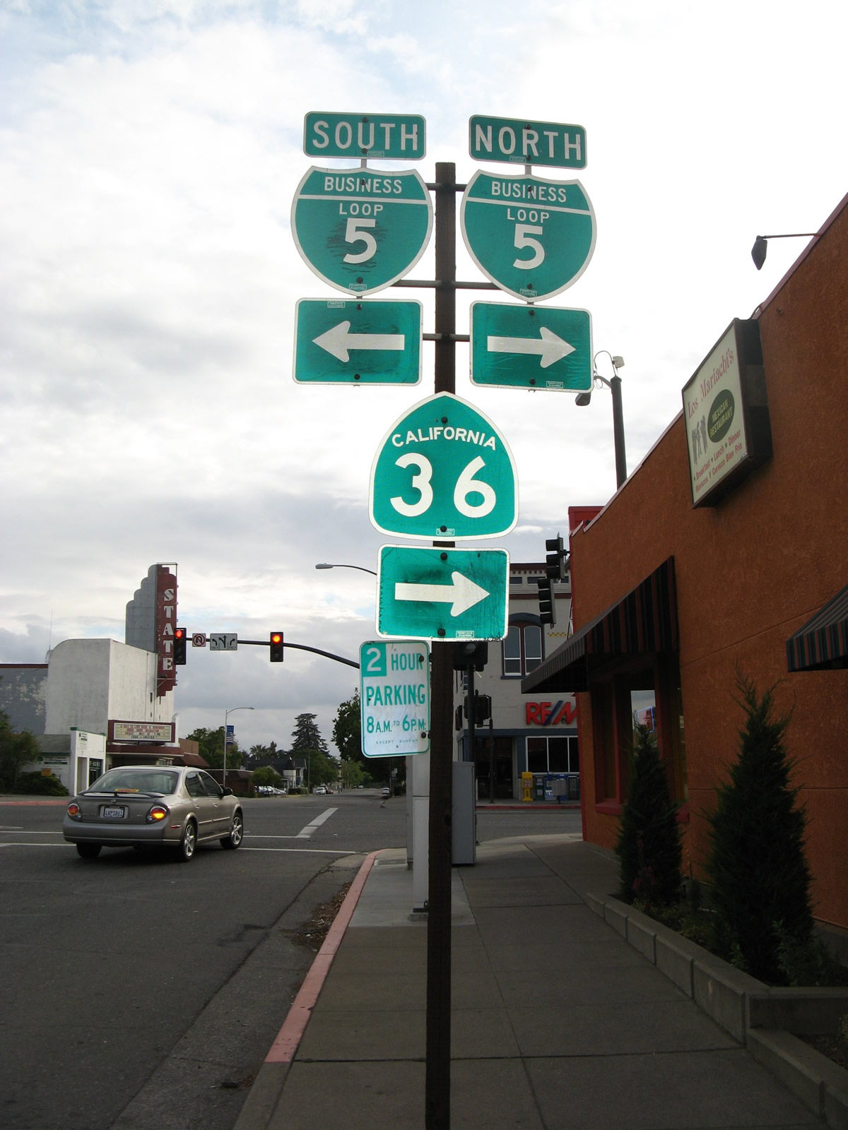
The California State Highway System Signing Log (October, 1991) indicates that Business Loop I-5 in Red Bluff follows Main Street. The route is interchangeably signed as both the business route and historic U.S. 99.
The 4.2 mile long route of Business Loop I-5 runs along old U.S. 99 to Downtown Red Bluff and northward along the Union pacific (old Southern Pacific Railroad) line. The historical alignment disappears ahead of the business route separation with SR 36 west.
Cottonwood
Redding and Anderson
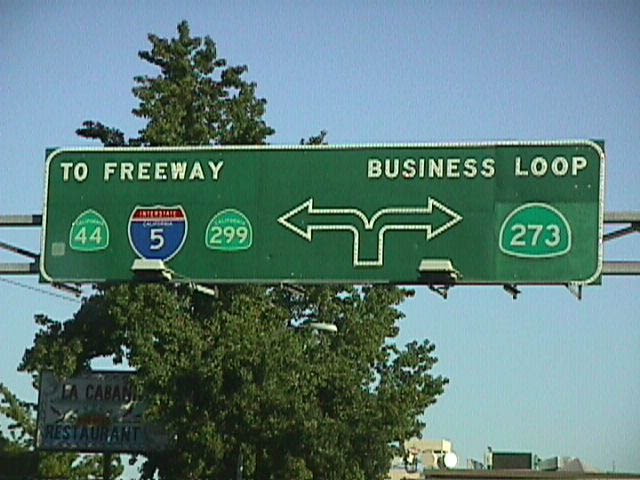
An older business loop for I-5 followed Old Highway 99 and Market Street (now SR 273) northward from Anderson to Redding west of Interstate 5. Old AAA California maps (1970s and 1980s) referenced what is now SR 273 then as Business Loop I-5. Jerry Mullady originally reported that Business Loop I-5 in Redding was no longer posted. This was field verified in May 2008.
SR 273 constitutes a four lane expressway northward from the split with I-5 at Exit 667 to the Union Pacific Railroad overpass in Redding, where the route transitions into a commercial arterial. Beyond Downtown Redding, SR 273 (Market Street) crosses the Sacramento River ahead of what locals refer to as the Miracle Mile, a stretch lined with old motels. Expressway standards ensue from there to a wye interchange with Interstate 5 at Exit 681.
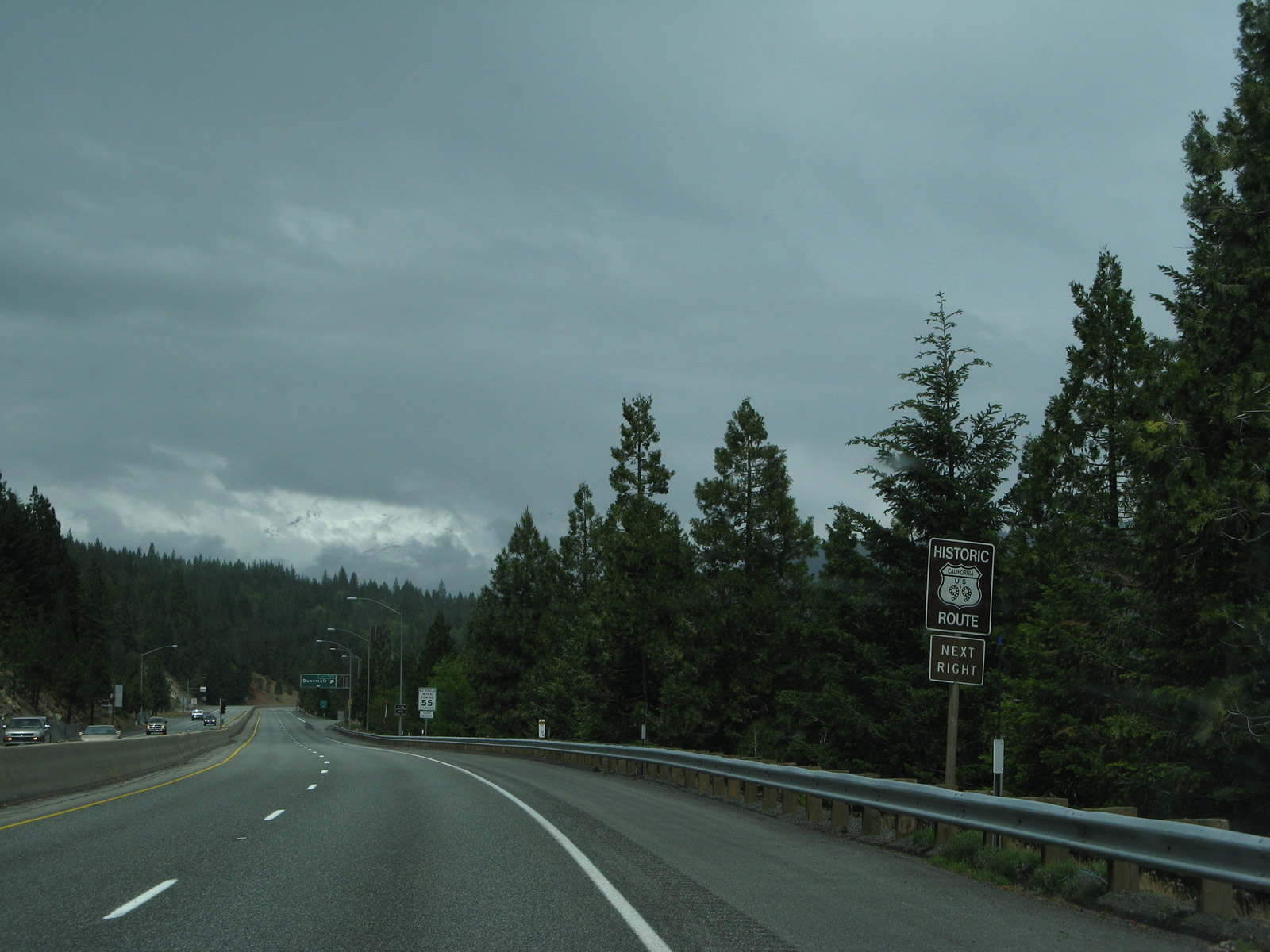
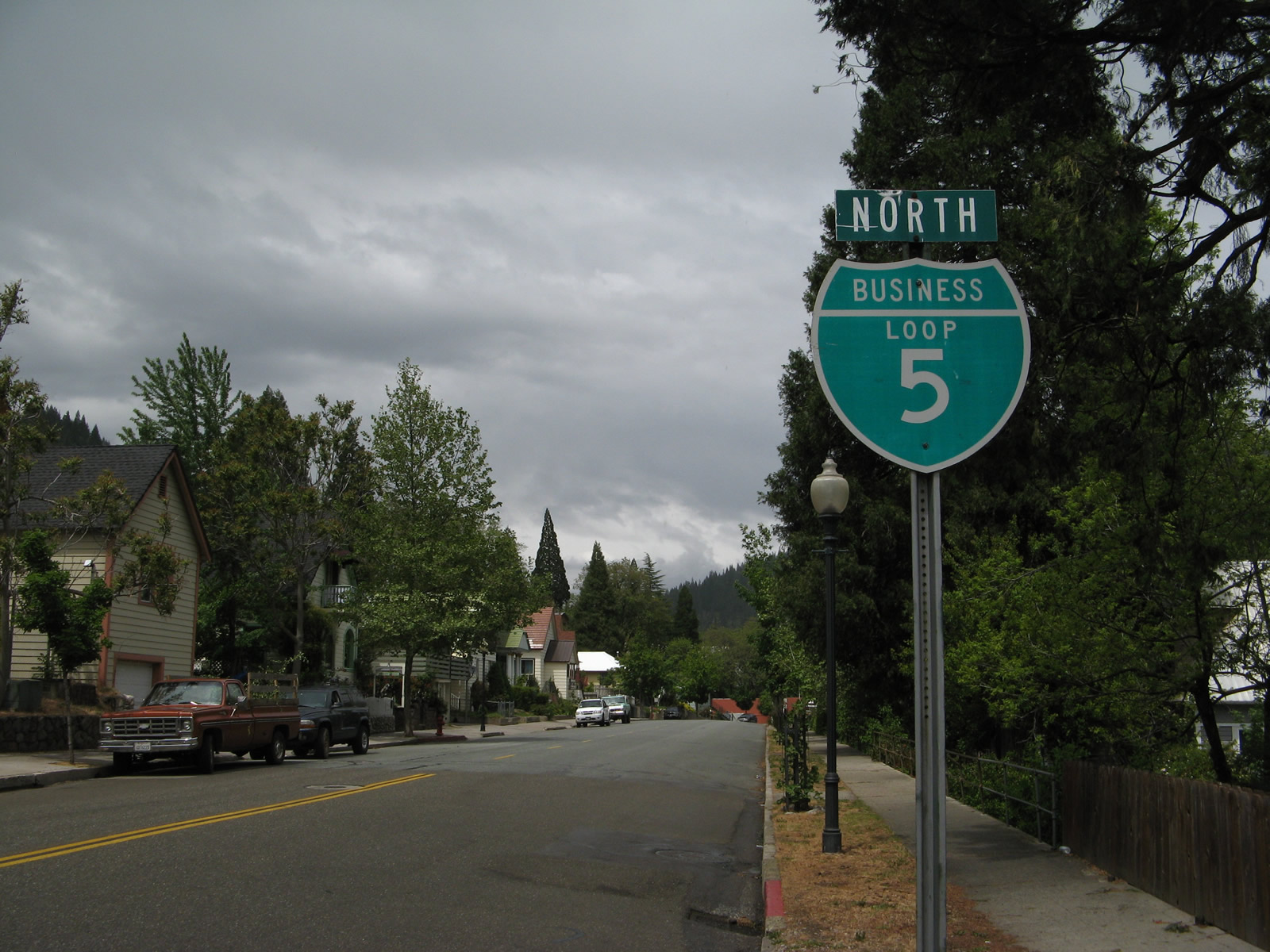
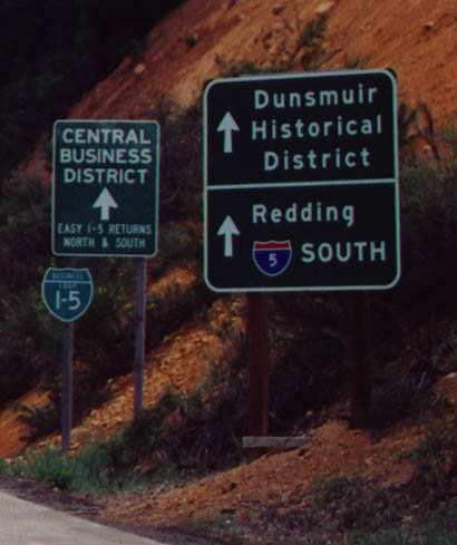
Dunsmuir
According to the California State Highway System Signing Log (October, 1991), Business Loop I-5 in Dunsmuir runs from “Interstate 5 and South Dunsmuir undercrossing over Florence Avenue to Interstate 5 and North Dunsmuir undercrossing and Siskiyou overcrossing.” Totaling 3.7 miles in length, the business route follows Dunsmuir Avenue in close proximity to I-5 from Exit 729 north to Exit 732.
Dunsmuir Avenue was marked with historic U.S. 99 signs as early as the late 1990s. These were taken down eventually, but replacement signs were installed for the route by 2008. A handful of Business Loop I-5 markers line the avenue otherwise.
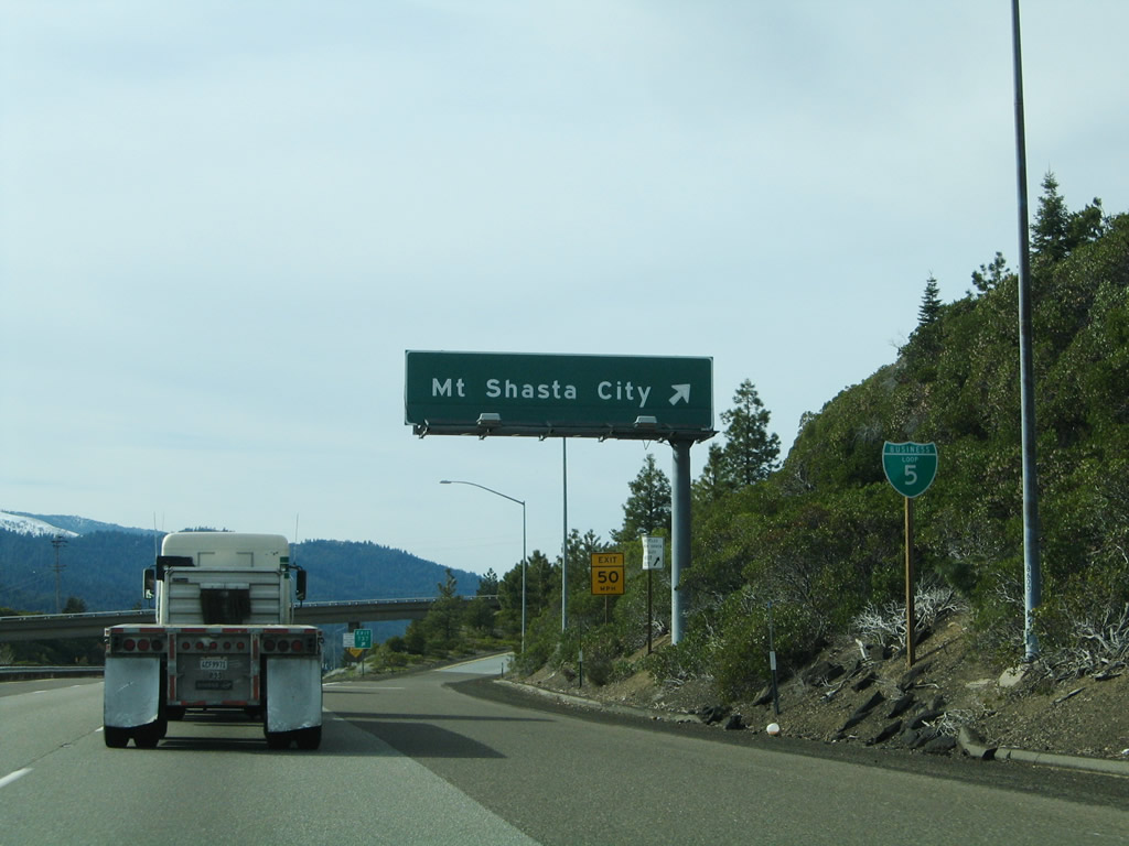
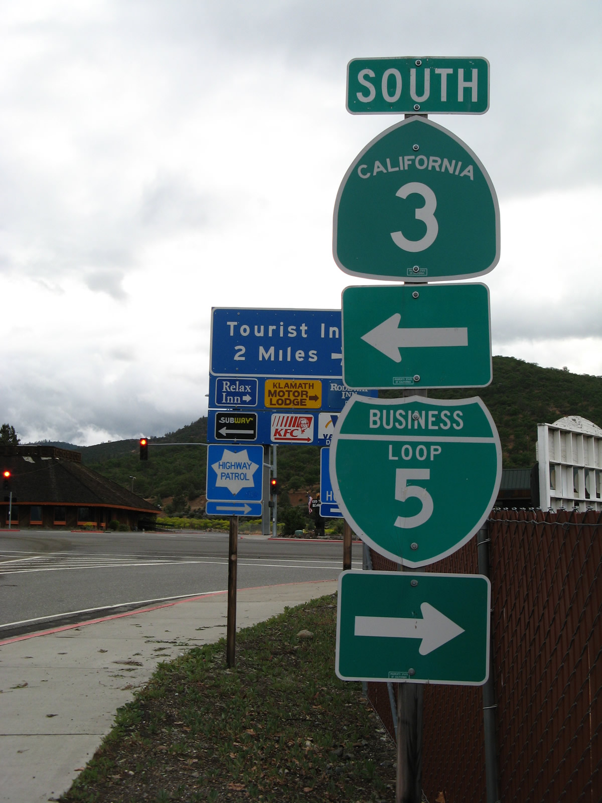
Mount Shasta
Shields for Business Loop I-5 appear at the north and south wye interchanges for Mount Shasta, but nowhere else along the 3.8 mile route. Mount Shasta Boulevard branches north from Exit 737 along old U.S. 99 to the city center at Lake Street. The boulevard splits with Spring Hill Drive before merging onto I-5 at Exit 740.
Weed
Traveling just 1.2 miles, Business Loop I-5 at Weed runs along the east side of Interstate 5 between Exits 747 and 748 along Weed Boulevard. The route coincides with the southernmost portion of U.S. 97 and as California 265 between U.S. 97 and I-5 at Exit 748. Shields for the loop only appear at the interchanges with I-5. The route is otherwise posted solely as U.S. 97 or SR 265.
Yreka
Business Loop I-5 through the city of Yreka overlaps with SR 3 north from Moonlit Oaks Avenue as part of a 3.8 mile long route between Exits 773 and 776. The two routes follow old U.S. 99 along Main Street.
A signed branch of the route loops north from Moonlit Oaks Avenue along Fairline Road (an east side frontage road for I-5) north to Oberlin Road west to Main Street.
Washington
Vancouver
Page 6 of the March 1967 edition of Washington Highways magazine included a photo of Interstate 5 south at what is now Exit 3 displaying “I-5 Business – Vancouver.” The route likely ran along old U.S. 99 between Exits 1 A and 3 and along Main Street north from Downtown.
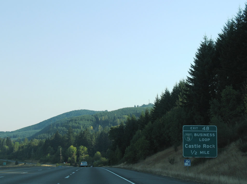
Castle Rock
The Castle Rock business route circles west from I-5 along Huntington Avenue (old U.S. 99) between Exits 48 and 49. The northern half of the 2.9 mile loop doubles as Washington State Route 411. The route is poorly marked through the Castle Rock city center.
Chehalis and Centralia
This route of Business Loop I-5 originally started at Exit 76 in Chehalis. It followed Parkland Drive and SW 13th Street to Market Boulevard (old U.S. 99) through the city of Chehalis. The historic alignment of U.S. 99 represented the business route north to Centralia, where Main Street west and Harrison Avenue north returned the loop to I-5 at Exit 82.
The route of Interstate 5 between Exits 78 and 102 was completed as a new alignment for U.S. 99 in the early to mid 1950s. This included construction of the National Avenue Extension, an east-west connector linking U.S. 99 on National Avenue in Chehalis with the freeway leading north to Centralia. The connector was temporarily a part of U.S. 99 until the eventual I-5 opened southward from Exit 79 to near Exit 52 within the vicinity of the Toutle River.
Mark Bozanich further added from an email sent on June 1, 1999:
When Interstate Business Loops were posted in Washington State in the mid-late 1960s, not only was old U.S. 99 from the south end of Chehalis to Exit 82 in Centralia posted as Business Loop I-5, but the National Avenue Extension (Chamber Way) was posted as Business Loop I-5 as well. This provided a way to use Business Loop I-5 to approach downtown Chehalis from the north without going all the way through downtown Centralia.
The National Avenue Extension was renamed Chamber of Commerce Way by the late 1990s. The route remained part of the Business Loop system for I-5, acting as a spur between the freeway mainline and National Avenue portion of old U.S. 99. Shields for Business Loop I-5 were still posted on Chamber Way in early 1999. One marker stands eastbound at State Avenue as of 2014.
Tumwater, Olympia and Lacey
The business loop headed east from Exit 102 on Trosper Road to connect with old U.S. 99 along Capitol Boulevard and Capitol Way north to the Olympia city center. The route lined old U.S. 99 east from there along the couplet of 4th and State Avenues to Martin Way through the city of Lacey. The north end tied into Interstate 5 at a wye interchange (Exit 114).
Fife and Midway
When Interstate 5 was opened from near Exit 136 at Fife to Exit 149 at Kent in fall 1962, U.S. 99 was realigned onto the new freeway. Mark Bozanich browsed the March 1967 edition of Washington Highways magazine and noted that a photo on page 10 of what is now the junction of SR 99 (Pacific Highway South) and SR 516 at Midway captured a southbound sign bridge with overheads displaying “I-5 South – Tacoma,” “I-5 Business,” and “SR 516 – Des Moines.”
U.S. 99 was decertified in 1969 and the Tacoma, Seattle and Everett portion of the route became SR 99. SR 99 in turn switched back to the alignment of old U.S. 99 from Fife to Midway.
Seattle
The collector distributor roadway along Interstate 5 for Dearborn, Madison and James Streets in Seattle was signed as Business Loop I-5 in 2018. Meant to clarify options for motorists along Interstate 5 northbound during the I-5 paving/expansion joint project, the designation is temporary.1
Everett and Marysville
This business route followed old U.S. 99 (Broadway Avenue) between Exits 192 and 198. The route north from Marine View Drive, including the span across the Snohomish River to Smith Island, is a part of Washington State Route 529.
Bellingham
Business Loop I-5 through Bellingham traveled a 5.8 mile course between Exits 252 and 258. Following old U.S. 99, the route zigzagged along Samish Way, Maple Street and Ellis Street before turning onto Holly Street through the city center. Business Loop I-5 then arced through the Columbia neighborhood of Bellingham via Broadway, Elm Street and Northwest Avenue. The northern segment traveled Maplewood Avenue through the Birchwood community to a wye interchange with I-5.
Business Loop I-205
Tracy

Business Loop I-205 follows Eleventh Street across the city of Tracy. The 9.6 mile long route separates from Interstate 205 at a wye interchange (Exit 4) to run east along old U.S. 50 to Downtown. The 11th Street expressway converges with I-5 at a wye interchange (Exit 458 A) just south of the exchange (Exit 458 B) with Interstate 205 east.
The business loop is only signed twice along the arterial oute through Tracy as of July 2018. A reassurance marker and overhead guide sign reference the route eastbound, while no signs remain westbound.
Sources:
Page updated March 10, 2019.
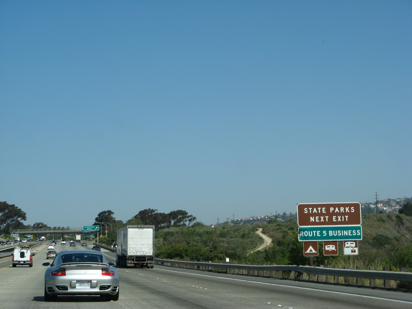
California generally references Interstate business loops once on a supplemental sign in text as “Route XX Business” on the freeway mainline.
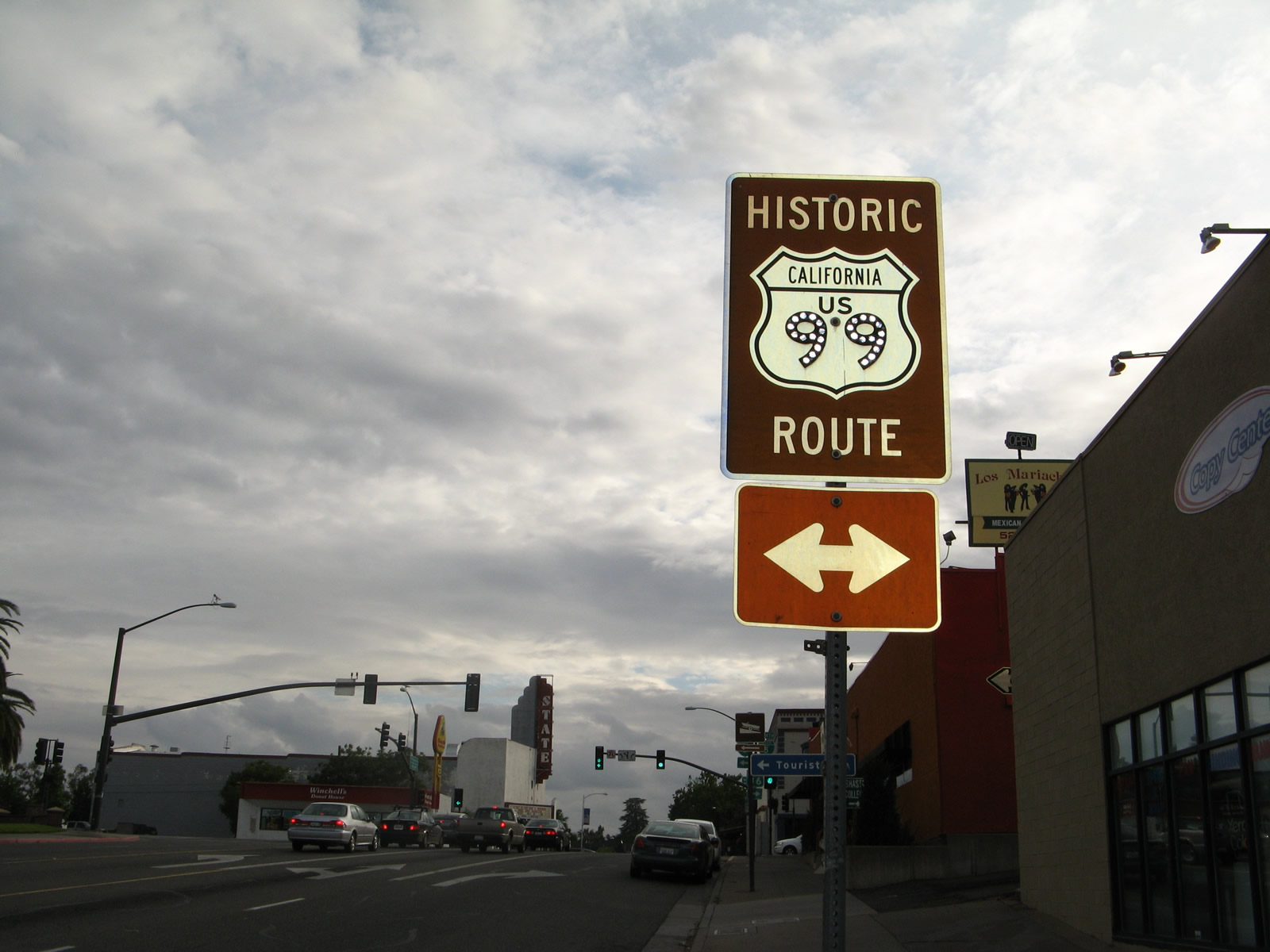
Signs for Historic U.S. 99 are quite common along the business loops of Interstate 5 in Northern California, especially in places like Red Bluff and Dunsmuir.

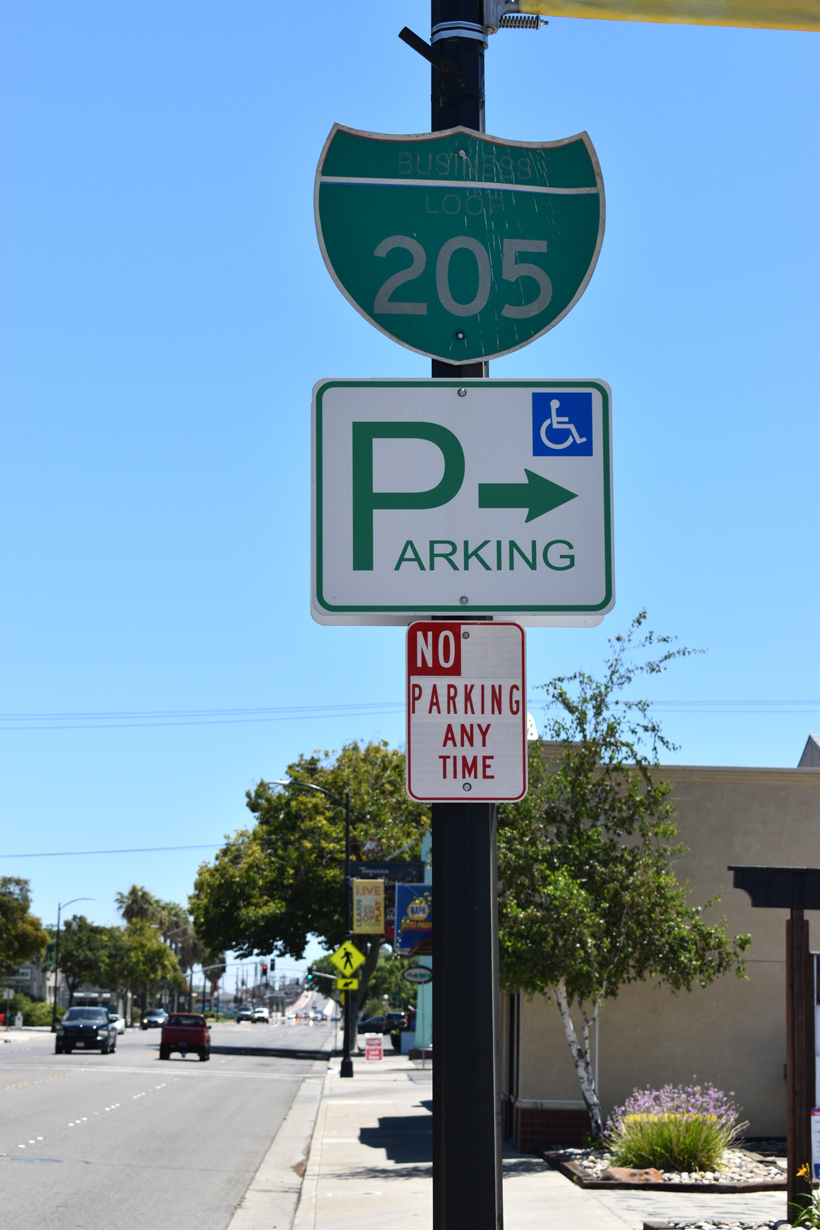
The stand alone shield posted for Business Loop I-5 at Exit 737 represents a rare shielding of an business route on an Interstate mainline in California. The one exception is the signing of Business Loop I-80 along Capital City Freeway at Sacramento.
The Castle Rock business loop is the only remaining business route for Interstate 5 in Washington. A handful of routes remain in service along I-90 as well.